Journal of Geomancy vol. 4 no. 3, April 1980
{12}
{13}
The rediscovery of geomantic principles needs to proceed on a twofold level if we are to reach a full understanding. At
present, quite rightly, most active research is microcosmic, based as it is on local studies of sacred sites and
alignments between them, or on the intensive monitoring of energy effects at a selected site or group of sites. At some
point we shall have to address ourselves to questions of a macrocosmic order, finally to see the local manifestations as
part of a greater pattern.
In surveying the macrocosm, a question of prime importance geomantically must be the location of the omphalos, the navel-centre on which such a pattern must depend if it exists at all. A number of answers have been proposed to date: as spiritual centre of Britain, some would have Arbor Low in Derbyshire; another proposes a site in Leicestershire; Nigel Pennick has suggested Oxford (1). If the omphalos is a geographical as well as a sacred centre, it must certainly be placed like these examples close to the median line through the length of the island. Outside the geomantic ranks there is some support for the site of Meriden in the Forest of Arden, Warwickshire, which is similarly central.
One method of resolving the question clearly lies in an application of dowsing techniques as outlined by Colin Bloy (2). Another approach, perhaps equally fruitful, is documentary, for there are still extant written fragments of the early sacred history and geography of Britain. An especially valuable source in this respect is the medieval collection of Welsh tales known as the Mabinogion (3): late though these tales are, they preserve something of the Celtic Britain of 2000 years ago, and Celtic culture was very much omphalos-centred.
A few examples of the Celtic Omphalos will suffice to indicate that this country must have had a nominal sacred centre in the late Iron Age and Roman period. The Galatian Celts of Asia Minor had a central shrine called Drunemeton, somewhere near present-day Ankara in Turkey (4). The Gallic druids had a similar centre in the territory of the Carnutes, supposed to be the site now occupied by Chartres Cathedral (5). The Gaels had a dual sacred centre at the ridge of Uisnech and the hill of Tara in Ireland (6). And Wales may have been divided in the first millennium CE from the mountain of Pumlumon above the source of the Severn (7). Given these parallels it would be surprising if Albion were not similarly centred on a Celtic holy place.
As Nigel Pennick has also observed (1), The Mabinogion gives the name of this place with little ambiguity. According to the Tale of Lludd and Llefelys in that collection, the island of Britain was wasted by three plagues which destroyed the fertility of the people, livestock, trees, waters and the land itself. This magical devastation, apparently caused by a severe imbalance of energies in the geomantic network, was countered in accordance with sound geomantic principles:
“And a while thereafter, Lludd had the island measured in its length and in its breadth, and in Oxford he found the point of centre. And in that place he had a pit dug in the ground, and in that pit he set a tub full of the best mead that might be made, and a covering of silk over the face of it, and he himself keeping watch that night. And as he was thus, he saw the dragons fighting; and when they were worn and weary they descended on top of the covering, and dragged it with them to the bottom of the tub. And when they had made an end of drinking the mead, they fell asleep. And in their sleep Lludd wrapped the covering about them, and in the safest place he found in Eryri he hid them in a stone coffer. The form by which that place was known thereafter was Dinas Emreis …”
Eryri is the Snowdon massif in North Wales, a likely enough place to divert an accumulation of ‘yang’-type dragon energy. Readers of British legend will be aware that the dragons were later disturbed again in the time of Vortigern and Ambrosius/Emreis (5th century CE),but that, as they say, is another story. {14}
The mythical British king Lludd is in fact a version of the one-armed Celtic god known variously as Nuadu, Nodens or Nudd, the patron of a healing centre at Lydney on the Severn estuary. He was evidently also the patron of the Celtic geomancers (presumably druids?) who “had the island measured in its length and its breadth”, for the practice of geomancy must have been closely associated with healing. The idea that the ‘barbarian’ Celts would have been capable of such a ‘sophisticated’ feat of applied geometry would doubtless raise a smile among orthodox Celtic scholars, but that need not bother us. For there is confirmatory evidence to suggest that Oxford or its environs did indeed constitute a ‘point of centre’ in late Iron Age Britain.
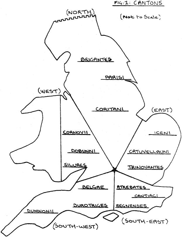
The evidence presents itself in Roman guise, in the distribution of the civitates or cantons which rationalized the earlier tribal divisions of lowland Britain. The Roman army of occupation established fifteen major cantons, each with its own capital town and network of military roads. The system did not extend to Scotland or West Wales, areas which never fell completely to Romanization, but covered the country known variously as Albion, Lloegyr or England. Using the analogy provided by the division of Ireland into provinces called coiced (fifths) (7), it is possible to arrive at a fivefold division of Albion as shown in Fig. 1.
To shorten the argument, the four central cantons had their capitals at Leicester, St Albans, Silchester and Cirencester, and their boundaries met somewhere in the kite-shaped area delimited by those towns (Fig. 2). It should be noted that although the establishment of these towns was due to direct Roman influence, the sites merely replaced the earlier oppida or central places of assembly; the territorial boundaries would in all likelihood have been established in the pre-Roman Iron Age. It will be seen that the geographical centre of this division lay in that part of the Thames valley now dominated by Oxford, thus confirming the tradition handed down in The Mabinogion.
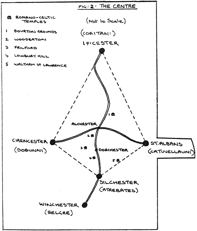
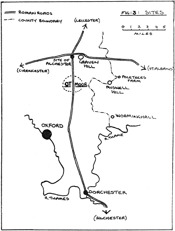
If it be accepted that this area of eastern Oxfordshire (OS Sheet 164 (Oxford)) did indeed contain the omphalos of Celtic Britain, it becomes necessary to choose between a number of sites in order to locate the centre more precisely. There are at least three hills that suggest themselves, if the omphalos is thought to occupy an elevated site. They are Shotover, which now accommodates the eastern suburbs of the city of Oxford itself; the isolated Graven Hill which stands over the Roman crossroads at Alchester; and Muswell Hill, the highest point in the area and (significantly?) a markpoint on the present county boundary with Buckinghamshire. If one concentrates instead on the dragons in the Welsh legend, a likely site is Worminghall (Worm- being a Saxon name for the dragon) which also lies on the county boundary. If a pre-Celtic sacred site is thought likelier, then I would nominate Dorchester-on-Thames, where stood a late neolithic henge-and-cursus complex – this ancient and rare sanctuary was, by the way, inviolate for something like five millennia until destroyed by the twentieth-century greed for gravel (yes, gravel!). Dorchester could certainly claim to be the omphalos of later Saxon England, for it was the first nucleus of the kingdom of Wessex as well as an important early bishopric.
But in the context of the Iron Age, none of these is quite as likely to prove a central sanctuary as something less immediately significant. The legend already quoted states that Lludd “had a pit dug in the ground, and in that pit he set a tub full of the best mead”. This calls to mind the numerous votive or sacrificial offerings recovered from low, marshy places, as well as pools or well-shafts, which characterize Celtic religious practice throughout northwestern Europe. In particular, the discovery of a magnificently adorned silver cauldron from a bog near Gundestrup in northern Jutland (8) might be cited here, for it is thought to mark the site of the central holy place of the Cimbri (a Celtic people who were especially active in the late 2nd century BCE). If Lludd’s tub of mead is at all comparable to the Gundestrup cauldron, then the pit in the ground might reasonably be sought in an area of marsh or fen. {15}
Unlikely as it may seem, the hills of this eastern part of Oxfordshire do enclose just such an area of low, level, marshy ground as would prove a classic Celtic bog-sanctuary. In the geomantic sense, it is the kind of area that would entrap dragon energy and generate baleful influences (Sha-ch’i?) without such intervention as is described in the tale of Lludd. The area in question is Ot Moor, a small fen just north-east of Oxford. It is bisected by the Roman road from Silchester to Leicester, following approximately the south–north axis, and a mile away stood the important Romano-Celtic temple at Woodeaton.
I don’t know whether the spade-archaeologists have ever recovered anything from Ot Moor that might indicate its former sanctity – if any reader is familiar with the area, perhaps they could provide information for me. The Moor did, however, preserve a living folk memory until the middle of the 19th century, and this may be of some relevance. On May Day (Celtic Beltane) a human-shaped figure garlanded with greenery used to be carried in procession across the Moor from Charlton to Studley, accompanied by morris dancers and musicians. Christina Hole (9) believes that this is originally a medieval ceremony, a veneration of the Virgin Mary, but might it not have its roots in the pre-Christian era?
It may be that the national omphalos is not a fixed site, rather that the centre is determined differently according to
the needs or beliefs of successive cultures. Thus, Arbor Low may indeed have been the major centre in the early Bronze
Age, and Leicestershire’s Croft Hill at another period. I have already suggested that Dorchester-on-Thames may
have been regarded as the national sacred centre by the early Saxon settlers. Now that religion has been replaced by
television, the BBC have re-sited the omphalos at
Daventry (and I’m not being entirely
facetious). And if the centre is a focus of human religious activity, rather than a fixed point determined by some
geophysical anomaly, then I believe there is a strong case for supposing that the “point of centre” of
Celtic Britain was indeed the enigmatic Ot Moor.
xxxxxxxxxxxxxxxxxxxxxxxxxxxxxxxxxxxxxxxxxxxxxxxxxxxxxxxxxxxxxxxxxxxxxxxxxxxxxxxxxxxxxxxxxxxxxxxxxxxxxxxxxxxxxxxxxxxxxxxxxxxxxxxxxxxxxxxxxxxxxxxxxxxxxx
(1) I have not read Nigel’s The Ancient Science of Geomancy (to my shame), but he tells me that he nominated Oxford as the national omphalos on the strength of the reference in the Mabinogion.
(2) According to the two papers published in JOG <vol. 3 no. 1 and vol. 4 no. 1>, Colin Bloy and his colleagues have identified a worldwide system of ‘telluric lines’ emanating from the Pamir mountains in Asia and reaching Britain by way of the South Downs.
(3) I have used the translation by Gwyn Jones and Thomas Jones, published by Dent Everyman. I believe that the Mabinogion is an indispensable source for anyone at all interested in the mysteries of Britain.
(4) Celtic sanctuaries are discussed by Anne Ross, Nora Chadwick and Myles Dillon, among others, in a number of easily-obtained paperbacks.
(5) The source for this is Julius Caesar in his commentary on the Gallic wars. Sometimes supposed to be unreliable on geographical matters, his statement that the druids had a central organization finds general acceptance among Celtic scholars. Chartres is not the centre of modern France, but may have been considered central by the non-Belgic and non-Aquitainian Gauls.
(6) Tara was apparently a later centre established for political and dynastic reasons. The boundary-stone at Uisnech might be compared with the navel-stone at Delphi, an omphalos in the religious sense.
(7) Celtic Heritage, Alwyn and Brinley Rees: speculative prehistory with academic approval.
(8) The Bog People by P.V. Glob: popular rather than scholarly, with a convincing reconstruction of some facets of Iron Age religion.
(9) A Dictionary of British Folk-Customs, another indispensable source.
(10) The Ordnance Survey Maps of Iron Age/Dark Age Britain – useful.