{21}
Let us turn now (Plate IV) to some examples of roads and alignments. A well-known instance of an ancient road directed towards a mound is the Roman road from Bath to Marlborough, which runs directly towards Silbury Hill, near Avebury in Wilts, and then bends to avoid it. It is not so well known that under this great artificial hill lie a number of sarsen stones, apparently in a circle. A burial-place, truly, but not for a human interment. You can see the hill in the distance, and the chalky course of the road heading straight for the hill. The two figures at the side of the road mark the positions of two rough stones, and the camera was at a third. The appearance of the stones is warrant of old age; and I cannot conceive that the Romans found it necessary to mark a made road by standing stones. The hill and the stones suggest that the Romans used an older track. These stones are now parish boundary stones, and perhaps they owe their survival to this fact.
There is an example of a Roman road, from Dorchester to Ilchester, which bears the traces of its origin in earlier days. The greater (the northern) portion of this road runs on a generally straight course from Hog Cliff Hill almost to where it crosses the Fosse Way, not on the direct course from Dorchester to Ilchester, but instead from Maiden Castle to the church of Somerton (which was anciently the capital of Somerset). This straight stretch (of approximately 20 miles) links up with Dorchester by a bit of the road which is directed towards the south-east to the stone circle at Poxwell, with the churches of Poxwell, Peverell, and Stratton in alignment. On this line, too, is the earthwork of Poundsbury, just outside modern Dorchester on the north. At the northern end the main portion of the road is linked with Ilchester by a straight bit of road (directed towards the church—the sole remnant of five) ; but I cannot find on its line any relation to other ancient sites—so we must give the credit for this short northern section to Rome. We note {22} that, at Ilchester, this road from Dorchester links with the great Fosse Way, itself thought by some authorities to be older than Rome.
This peculiarity of a so-called “Roman” road starting out not in the direction of its further terminal is a not uncommon phenomenon. The “Roman” road running westward from Dorchester (through Bridport to Axminster and Exeter) starts out on an ancient alignment. There does not seem to be any adequate reason why—if Rome initiated it—it should not have started out on the direct line to Exeter; but it does not point direct to that city. Rome having been a practical nation, one can only presume that she made use of stretches of road that she found ready to her hand.
Parish boundaries are often accepted as evidence of the former course of an old road, which is usually said to have been of Roman origin. There seems to be a quite common idea that our forebears never made or marked out the course of a road before the Romans cast covetous eyes on this island. A friend, in the West, once asked me why a certain parish boundary ran so straight for a matter of three miles in what is generally thought to have been country that was never settled by the Romans.
It happened that I had marked on my own map (one which did not show parish boundaries) an alignment of mark-points (mounds and churches) starting from the actual coast line in North Cornwall. This map sheet is of North Tawton, in Devon.
When I found that my line ran along his boundary I told my friend that he would probably find an ancient road there, if he went to look for it. He was (and is, for all his experience) still a profound sceptic about my “fantastic” ideas and Mr. Watkins’ theory, but he obediently made quite a long pilgrimage to see for himself, and found an old hard track following the line of the hedge which marks the parish boundary. You could see the hump of the track, and a little farther on a nice little standing stone on the same line. It had been used as a gate-post at some time; but it is quite a usual experience, in Devon at any rate, to find an {23} old stone used as a gate-post on an alignment. If the paths run with the alignments, what would be more natural than that, at some time, some of the stones should be made to support gates on those paths? There is no track of any sort shown along this line on any of the 1-inch maps on which I had been working.
An experience such as the above can easily be gained, viz. by tracing, on the map only, a probable line of old road and then finding it still plain on the ground. This is a case in point. A spot on the map was selected as a likely place from which to commence a search in the field, near a very detached little church, close to my own home in Devon—Ven Ottery by name. It lies on a longish alignment. On proceeding to that line the first thing that I saw, from the car, was the track running across the field, exactly on the selected line. I could see the little church and the track running towards it. This ancient road can be traced across the River Otter, westward, in the direction of Dorchester. The river has altered its bed very considerably since this particular line of road was used.
On another occasion I went down into Cornwall, over the Devon border, with some friends, chasing an alignment already marked on the map. We selected, at random, from the map a point on a by-road where the alignment crossed it, to pull up. Here we found two old stones waiting for us! The local people could not explain their presence.
When meditating an expedition into Herefordshire, Mr. Watkins’ own country, I selected, from the map, on an alignment, a likely looking spot to look for a bit of the old track; this was the edge of a wood, at the bottom of a steep hill, and on the extreme edge of the wide, flat valley of the Wye. When I got down to the river-level on the alignment, I found the old track up against the edge of the wood. The hard raised track was plainly visible, marked out by the line of molehills, the farthest point to which the moles could burrow. I also found some other bits of the same old track at different points, long distances apart, on the alignment.
With these experiences in mind one cannot help being {24} convinced that in many cases at least the old roads really have a connection with the alignments. It is impossible even to hazard a guess at the possible age of the inception of these tracks; but I have found some pointers towards round about 3000 B.C. as a minimum date, that date being based on a geological theory, itself based on archaeological ideas at the time of publication of that most interesting little book called Submerged Forests, by Clement Reid.
Mr. Watkins, in his book, mentions his own experiences of finding buried tracks exactly on alignments already drawn in on his maps; tracks buried in the Wye Valley, and discovered during drainage operations. Whatever the sceptics may say, this sort of thing, in my opinion, cannot be fortuitous. The alignments exist, and the old tracks are often connected with them. But in saying that, it is not conclusive evidence that the alignment was set out expressly in order that the track might have a line to guide its development.
Critics often object to the use of the small scale of the map on which exploratory work has to be carried out in practice, viz. the 1-inch O.S. maps. One has to make use of the materials at one’s disposal; the 6-inch scale does not contain enough area on the sheet; the 25-inch is simply unworkable for the same reason, as well as others; the ½-inch is positively inaccurate—at any rate when looking for alignments, simply by reason of the smallness of the scale. As a matter of fact, experience has shown that the 1-inch scale results work out extraordinarily close when checked on the 6-inch scale, where such a check has been applied. To do this, it is necessary to use a method of calculation, particularly when (as in most cases) the line extends over a number of sheets of the 6-inch map. This is a very laborious business and liable to be expensive, as many map sheets may be required.
A check carried out by the Ordnance Survey Office, for myself, of a line drawn between two points nearly 100 miles apart, showed that the line I had drawn by the comparatively rough formulae that I had used, and theirs by the most scientific method, were so close that the greatest {25} divergence between the two was not appreciable on paper at the scale of 6 inches to the mile.
I have an example of a 6-inch plot which was first “explored” at the scale of 1 inch. The alignment started at an old causey on the road from Exeter towards the east—the main London Road—at a place still very “liable to floods.” A few miles on the line passes practically along the line of the church at Awliscombe (near Honiton in Devon). The orientation of the church is with the small bit of road beside it, and with the alignment. This agreement between the orientation of a church and the alignment is a phenomenon to which Mr. Watkins often referred. The line passes exactly along the rather peculiarly traced northern vallum of the earthwork on the hill known as Dumpdon (very prominent from the London road, with its clump of beech trees). Time and again Mr. Watkins has pointed out how often an alignment passes along the vallum or ditch of an earthwork, not through the centre as one might expect. As far as the experience of students goes, there is practically nothing in the physical phenomena stressed by Mr. Watkins which the students of his theory have not corroborated. The same thing is practically repeated at another small earthwork, a few miles farther on, just over the Somerset border.
Continuing the alignment, some miles on we strike the village of Maiden Bradley, where we pick up a mound in the centre of the place. Near Warminster we run up against a large mound in the front garden of Bishopstrowe House; a nice thing to have immediately in front of one’s entrance door. A visit to the owner disclosed a small stone in a hedge a couple of hundred yards from the mound, not marked on the map, but exactly on the alignment, to the north-east of the house. The owner had often wondered why the stone was there, but no one knew! A bit farther on, on Salisbury Plain, the circular portion of the mound, a long barrow known as Bowl’s Barrow, falls on to the line, and the church of St. Michael at Little Bedwyn does the same. Farther back to south-west the churchyard of South Barrow (significant name) comes on to the line.
At Redlynch cross-roads (in Somerset) we pick up the {26} old road known as “The Hard Way,” said to be a prehistoric “tin road” running from Cornwall into Thanet. I rather mistrust the conception of one road definitely planned over the whole of such a distance, but prefer to think that there was a series of roads linked up, which have come to be regarded as an integral whole. The church of Redlynch, in a private park, falls exactly on the alignment; but, as far as I can make out, this is an entirely modern church on a modern site, but, being so close to the crossroads, it just happens so. At the cross-roads can be seen the course of the older road which preceded the present line of road. Another bit of road with an old name, viz. “The Broad Way,” conforms near enough to our line to support the theory of the evolution of our old roads.
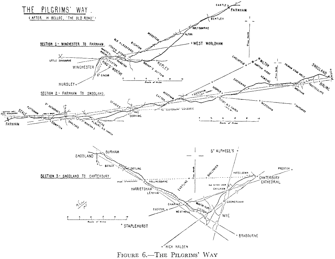
Figure 6. Perhaps the best known of the old roads in the South of England is the (so-called) Pilgrims’ Way from Winchester to Canterbury. It is really a combination of roads. This seems to be the fact in that its course, as traced in the books, changes so completely for the different stretches. But it displays, on those stretches, the phenomena of “The Old Straight Track.” In the diagram the three sections shown are all drawn to the same north point. To get the whole on to one block has made it necessary to draw it to a rather small scale.
Incidentally, it is a little remarkable and interesting that Bunyan, in his Pilgrim’s Progress, describes the Way as “as straight as a rule can make it” and “cast up by the Patriarchs of old,” and marks it by mound, stone pillar, and stone cross. In this connection it is equally interesting that Michael Drayton (1563–1631) writes, in Polyolbion:
“To guide my course aright.
What mound, or steady mere
Is offered to my sight?”
hinting at a definite connection between tracks and the features named. Mr. Watkins mentioned the Pilgrim’s Progress as I have given it, and for the second quotation I am indebted to a fellow-member of the “Straight Track Club.”
{27} As traced by Belloc (in The Old Road) the Pilgrims’ Way shows alignments of churches all the way from near Win- {Figure 6} chester to Canterbury, corresponding to the various changes of direction of the Way. It seems likely that the shrine was a very holy place long before Augustine came.
{28} Judged by the theory we are considering, Canterbury seems to have been also the eastern end of the old “Harrow Way,” which is said to have started from Stonehenge and joined the Pilgrims’ Way at Farnham Castle, from thence running along the top of the Hog’s Back, and so on to Canterbury. There are a few churches to mark its course, but (as it fell out of use as a Way in such ancient times, before the era of church building) there are not many of them.
The ancient sanctity of the site of Canterbury is evidenced (if it were necessary) by the recent finding of a broken—but now repaired—standing stone under one of the towers of the Abbey of St. Augustine there.
Note in the plan how in Section II alignments of churches run parallel to each other. Note also that we get the so common cross alignments of churches, crossing at churches. These phenomena have already been remarked on elsewhere. One stone circle (that of Coldrum) falls on the alignment in Section II.
Surely the alignments of ancient sites on which these old roads grew up must antedate them. This plan was drawn from the 1-inch scale map.