{29}
On Dartmoor (Figure 7), not only are there alignments of the old stones and crosses, but they fall, strangely enough, into parallel, or approximately parallel, lines, giving, again, intersections at mark points. The “nearly” parallelism can be explained in the same sort of way as the “quite” parallelism, but not by supposing that the marks were set up to mark the way for tracks—straight or winding; but by supposing that these sites are arranged in some definite geometrical pattern, which—it is easy to see—could give rise to all the peculiar phenomena that appear throughout this investigation. One must, for the time being, set aside the natural question: “Who could do such a work, and with what object?”
If such an idea—viz. that the ancient sacred sites of all forms in which we see them to-day fall into geometrical pattern—is correct, it still does not do away with the fact that old roads do, indeed, conform to the ancient alignments; it merely means that, the sites having been fixed in very far-off days, those sites became (in one way or another) well-known points on the land; and as time went on people just walked from one well-known point (land mark) to another, and so our “straight tracks” became beaten and many of them remain in use to-day. It is not necessary that those who first walked the original track should have known of the alignment, which perhaps ran on for many miles beyond their own destination.
If we pursue this investigation whither our discoveries lead us, it will not be back along roads at all. We have got an undoubted connection between the alignments of the ancient sacred sites and the old roads; but are the ultimate origins of the two connected?
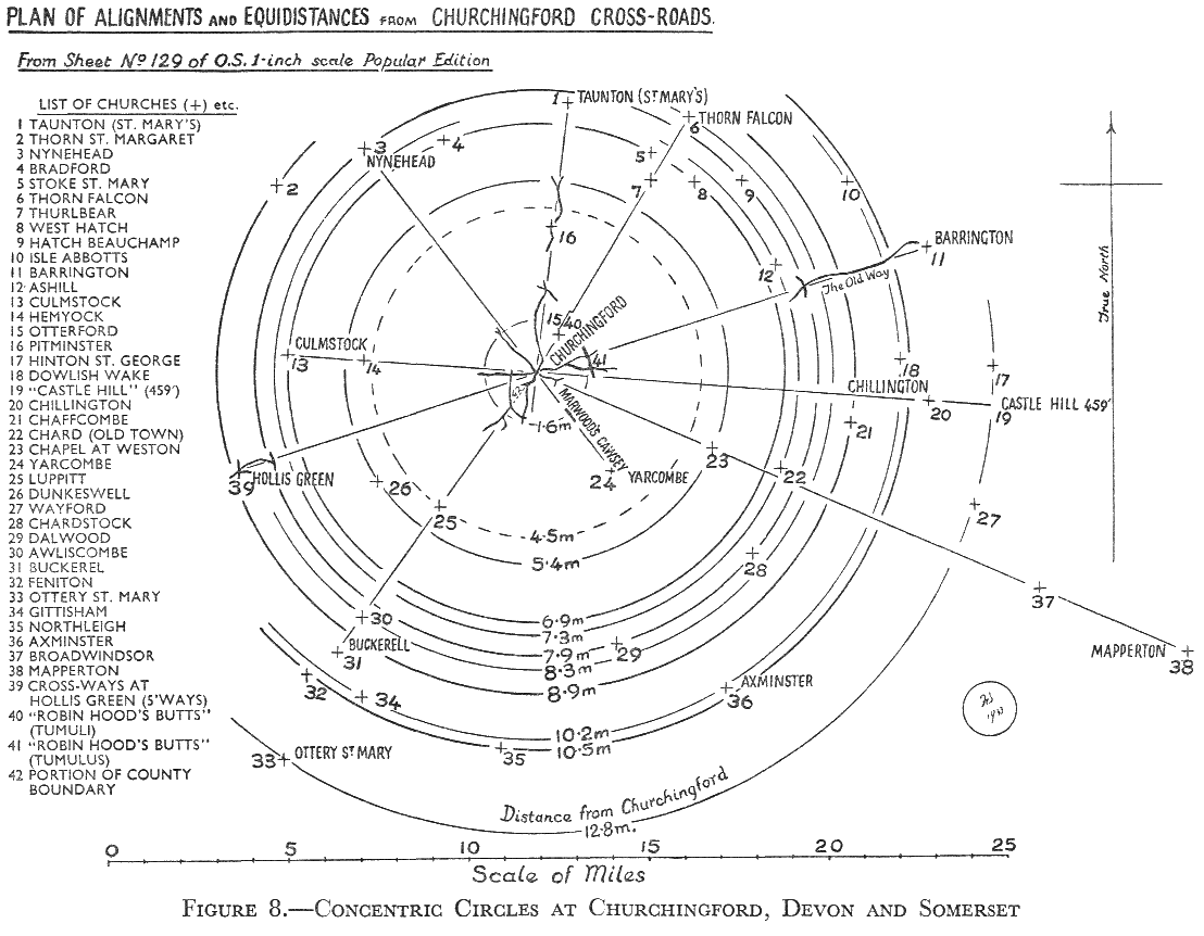
The points which give us to doubt are: the alignments are so numerous that it is difficult to imagine that they could all have been required to mark tracks; the peculiar parallelism of alignments, which in some cases are so close {30} to each other that one cannot see any possible need for their marking of separate tracks; the intersections of many alignments at a single site; and, above all, the fact that we find two or more sites that lie equidistant from one other; {Figure 7} and, as at Churchingford (Figure 8), we find many cases where from a common centre we can draw concentric circles, each circle taking up two or more sites. All these phenomena can, I think, be accounted for only by supposing that the sites are all points in a geometric pattern, very wide spread, the points in which had some sanctity and were marked, in very ancient times, for that reason and were {31} gradually adopted for the site of a burial-place (mound), a place of worship (stone circle), and so forth, till we find {Figure 8} the Christian church as the latest edifice on the spot. Probably the “Sacred Stone” was an original mark, as we find them so frequently.
{32} This diagram is from the 1-inch map showing the little village of Churchingford, where there was never a “church” as commonly understood. Six roads (or “fords”) meet to-day at the centre of this (at present) unimportant little village, not far from Taunton. Each road has its corresponding alignment, which in one case, at any rate, links up with road bearing an old name, viz. “The Old Way.” You can see that it is possible to draw concentric circles, centred on the road junction at the centre of the village, each circle taking up at least two churches, and in some cases more.
We postulated that a minimum of four points were necessary on an alignment. But for circles not so many is necessary. A mathematical friend, who was interested in Mr. Watkins’ theory, has assured me that, if one can describe, from a common centre, a number of circles, each of which takes up two or more of these ancient sites, then one can—very soon—rule out the element of chance, and feel confident that this phenomenon must be due to a purposeful arrangement of the sites in geometrical form (a “grid”). He said that as few as two sites per circle, if the number of circles is sufficient (two, I think), is enough to provide the evidence (see Appendix I).
Couple this with the other so-common phenomena, and it seems that it is only possible to explain the mystery of the alignments by postulating what I can only call a geometrical “grid.”
The roads are explainable by supposing that travellers walked from well-known point to well-known point, possibly without even knowing that these points lay in extended straight lines at all! And that may have been long ages after the sites were originally marked.
I cannot see the origin of all this in tracks. Anyway, why should a track, per se, lend a sanctity to the sites on which the way-marks stand? The sanctity must (so it seems to myself) relate to some quite different origin, as stated above; something quite different, much older, and of far deeper meaning. There must be that ancient worship (we call it “Sun Worship,” but know so little about it) behind {33} it all. Mr. Watkins and others claim that some of the alignments are directed to sunrise or sunset. This may be so, but except over very short distances this seems to be an astronomical impossibility. Theories connected with the orientation of stone circles come in here. I would be the last person to say that there cannot be any sort of connection between the arrangement of sites that I speak of—“the grid”—and this orientation; but it is a special subject, and is not essential to the argument in this stage.
As to the earthworks, which loom very large in this investigation, the physical facts of their distribution seem to put out of court any idea that the sites on which they stand were originally selected for defensive reasons, whatever purposes they have subsequently been devoted to, and whatever form they now present. There has been plenty of time for such change since their first consecration, as in all connected with the inception of the whole plan. As excavation of the earthworks goes on, we seem to be getting further back in Time with them. My own belief is that the sites were originally selected for the purposes of religious ritual—one may say, as the “churches” of very ancient days. Such a belief was held by some in the last century, but to-day is regarded as sheer heresy. I am a heretic! Hadrian Allcroft, in his Earthwork of England, says (p. 18): “That some of our surviving earthworks were originally constructed, for religious purposes—incidentally, that is—is universally admitted.”
In the same work, Allcroft gives what seems to be a key. Though, on the whole, a firm advocate of the “defensive” idea, he notes (on p. 104) that certain three earthworks, of large size, in Dorset, lie in a direct line and are evenly spaced at 9 miles distance—18 miles between extremes. He wrote in 1908. But apparently he did not pursue this curious fact further. The three earthworks are: Maiden Castle, that on Eggardon, and that on Pilsdon Pen.
In the general area in which these three earthworks lie, there are (besides an enormous number of alignments of the camps) a large number of distances between such sites (of which I count sixty large and small on the single (½-inch) {34} sheet) of Allcroft’s 9 miles, 18 miles (double), and 4½ miles (half). There are also quite a number of cases where more than two sites lie equidistant from one other. Had Allcroft looked further (perhaps he did, but he did not publish it) he would have found a fourth earthwork near Sheafhayne, and a fifth at Powerstock; not large ones, like the three he named. The distances pan out well. Sheafhayne is distant from Pilsdon Pen 10·2 miles. Powerstock is the same distance from Maiden Castle. Powerstock is 18 miles from Sheafhayne, the same distance as that between Maiden Castle and Pilsdon Pen.
Now if we take centre at the earthwork near Cattistock (chosen for irrelevant reasons), with radii to each of the five earthworks on the base line, the circles drawn all pass through at least one other earthwork; and in the case of that through Sheafhayne, which is the farthest from Cattistock, we find as many as five earthworks lying on it. I have not examined the actual lengths of these radii. Down in the south-east is another pair of earthworks (unrelated, apparently, to the “base line”) equidistant from Cattistock.
There is another interesting point here. The great earthwork on Hamdon lies at an exact right-angle from Pilsdon Pen–Sheafhayne, and at the same distance from Pilsdon Pen as does Sheafhayne.
Surely this, coupled with the other instances mentioned, points to geometrical siting, and one can see more than a tendency to geometrical lay-out of earthwork sites.
Though Allcroft did not record any such examination of the earthwork sites as a whole, he made, in his later book (The Circle and the Cross, vol. i, p. 227), a most remarkable note on a discovery by F. W.W. J. Andrew, F.S.A., that the stone circles of Derbyshire (and, he suggested, possibly also those of Aberdeenshire) are geometrically arranged at even distances. Andrew’s idea was published in Memorials of Old Derbyshire in 1907. This slightly ante-dated Allcroft’s work on “Earthwork.”
Allcroft attributed this systematic arrangement of the stone circles to “The Druids”—a generic term for the ancient priesthood of all Time, because none other were known in {35} Britain apart from them. He challenged the archaeological world to disprove the geometry and to contravert the Druidic idea. As far as I know, the challenge has never been taken up. I have found something of the sort myself amongst the stone circles of Dartmoor. And now, it seems that such a geometrical arrangement extends throughout the ancient sacred sites in every part that I have tested. As yet only the fringe has been touched.
Others have noticed something of the sort; for instance, Sir Norman Lockyer (in Stonehenge, second edition) has a chapter under the head of “The Inter-relation of Monuments,” and in this he states—what is easily tested—that Stonehenge, Old Sarum, and Grovelly Castle lie at the angles of an equilateral triangle, whose sides are each 6 miles in length; total perimeter, 18 miles. The same distance again.
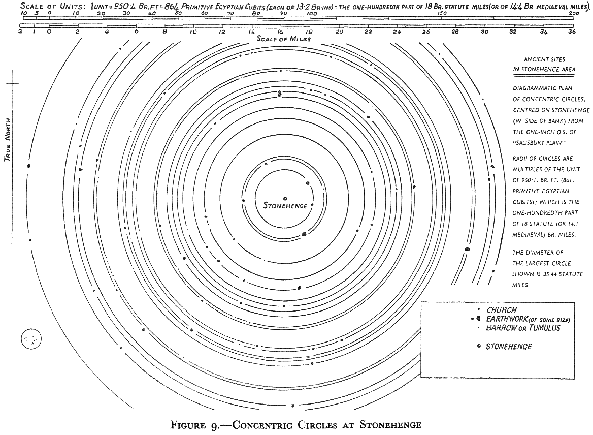
Figure 9. The 1-inch map of the Stonehenge area has the structure practically in the centre of the sheet. On it we can find many examples of these distances of 18 miles, and its fractions, between earthworks. We also find these concentric circles centred on a point in the area; not in the circle proper, but on a point on the western side of the enclosing vallum.
The sites which are taken up by the circles shown in the diagram include—besides the larger earthworks—small tumuli and churches. One circle has on it as many as eight sites, of which as many as six are quite small tumuli. Other circles take up: some, three sites; three circles, four sites; two circles, five sites; two circles, six sites; and the one circle mentioned, eight sites.
This seems most significant; but more remarkable is the fact that the radii of all these circles are multiples of a definite length, which is the one-hundredth part of Allcroft’s “key distance,” viz. our 18 miles. (Actually, 950·4 ft. = nine divisions of a scale of fiftieths of an inch.)
In Devon there is a system of stones, consisting of a cromlech and its attendant longstones, which gives one dimension in its geometry exactly equal to this 950·4 feet.
To arrive at such a result was only possible by using the {36}{Figure 9} {37} little unit of measure, called by its discoverer—Mr. Ludovic Mann—the “alpha unit,” and attributed by him to an origin in palaeolithic times. Incidentally, I find in this same system of stones a dimension which relates to the length of the base-side of the Great Pyramid of Egypt. Not that I think that the Pyramid measurement was transplanted to Devon, but that the measure (being a standard measure of ancient times) is thus to be found in both places. It is equal to the one-four-hundred-and-eightieth part of a degree of the equatorial circumference of the earth as known to the ancients, which is very close to the latest scientific figure. It is appropriate that such a measure should be used in the laying in out of such a great geometric pattern as we are discussing.
I should like to stress that the things that matter are the sites on which the earthworks and other ancient constructions stand—not the constructions that we now see standing on them. These are mostly appropriate, as in the case of consecrated constructions, such as churches. The sites themselves are of ancient and everlasting sanctity.
This idea has unfolded itself from a long study of Mr. Watkins’ theory, and I cannot claim any originality; the circular idea itself first came to me from a friend, now passed on.
The whole matter is obviously one that needs a very lengthy study, and on entirely novel lines—novel to orthodox archaeology. The basis of the suggested geometry seems, at present, to be an arrangement of circles intersecting each other and governed by exact distances, which are related to Allcroft’s original distance of 18 miles.
The eastern counties show the same sort of thing. Sheet No. 76 of the 1-inch Ordnance Survey (fourth edition), published as the “Thetford” area (Norfolk and Suffolk), shows a large number of alignments all focusing at the tumulus called “Hut Hill,” as far as this one map sheet goes. I think that the largest number of points on one alignment is seven. Here is the expected circular arrangement in the same area. That is, equidistances from the centre on the same Hut Hill; again, I have not measured up the distances. {38} Many circles drawn with this centre take up two points, several three, and a couple four.
Many more such arcs could be drawn from other centres on this map sheet. Actually, I did draw more from four other centres; and it is an interesting fact that the church at Stoke Ash (in the south-eastern corner of the sheet) is on arcs of equidistance from four of the five centres, as well as being on one of the alignments through Hut Hill.
I have already quoted to you the opinion of my mathematical friend on the subject of fortuitous siting, in the case of circles. Chance would not, according to this ruling, come into this arrangement.
How often does one look at a tumulus without any idea of what it really may mean to the history of this land of ours. It marks a consecrated spot, of antiquity far ante-dating any of our recognized periods. It appears that the sanctity has not been conferred on it by any burial that has been made there, but that burial was made on the already sacred spot. I am not prepared to assert that all tumuli are on anciently consecrated spots. A custom may have arisen of making a mound over a burial without any reference to this quality of sanctity; perhaps at dates when the capacity of detecting this existing sanctity had been lost. I do not suggest that ready-made mounds were, of old, found on these spots, but that the priests (usually thought to have been charlatans) used to have the capacity of recognizing such spots; and I am not at all sure that the capacity does not still exist among many people not strictly “priests.” It appears that there are a number of “dowsers” (water diviners) who have (unwittingly) detected the consecration, which gives the same reaction to the dowsing-rod as is obtained from water. This, however, is a suggestion of my own, and I do not ascribe this idea to others. Anyway, it is a romantic one, even if not based on logical reasoning.
The idea of a geometrical arrangement of the ancient sacred sites is, as I have said, not a new one. Mr. Watkins’ theory of the alignments of such sites has merely given rise to a revival, but a much extended one, and related to a more distant age than has previously been suggested.
{39} I am well aware of the objections that can be, and have been, advanced to the notion that these ancient sites are geometrically sited. But facts are stubborn things, and cannot be ruled out by theory. What the explanation may be I am not yet in a position to state. But there the earthworks are, in many cases, 18 miles apart and in alignments; and there they are, mainly on the hill-top, and displaying the symptoms of a geometrical arrangement.
Sir MontagueMontagu Sharpe put forward a well-thought-out scheme to account for such a geometry within a limited area (Middlesex and Herts), but not including, I think, any large earthworks; and he ascribed it to Rome. Perhaps Rome, consciously or unconsciously, made use of existing sites. Their land measures may have agreed with those which they found here. Measures seem to have come down from a tremendous antiquity, and thus to be connected over a very large part of the earth’s surface. For instance, it is interesting to find that Sir William Petrie gives the old English “foot” as equal to a measure found as far afield as Mohenjo-Daro* in India, viz. 13·2 British inches; and we find that the same authority gives the old English mile as 6,000 of these old feet; and we find, to-day, that 1,000 of our present-day English acres exactly equal this old English mile squared. This can hardly be a fortuitous “coincidence.”
* Approximate date 3000 B.C.
Something of the same sort seems to be found in Anglesey, that home of Druidism. Mr. Evans, in his book The Sarns and Menhirs of Anglesey, gives his opinion that—
“We should look further than the comparatively recent period of the Roman invasion for the origin of our basic institutions, and … we must, in all our investigations into the mysteries of antiquity, infer some wonderful (and possibly world-wide) civilization, as underlying all known history.”
Mr. Ludovic Mann, with his measures of length dating back to palaeolithic times; and Mr. Reid Moir with his “human organization” of the same period, seem to support the same general view as that taken by Mr. Evans.
{40} I confess that I feel in complete agreement with those who hold such views.
Speaking of the distribution of palaeolithic implements Mr. Moir said that—
“Its implications must be faced. These are numerous, but the chief in importance is that there existed some form of human organization in those remote days. For many years I have believed and stated that the current view of the material status of prehistoric man, as judged by stone implements which represent merely the ‘insoluble residue’ of his culture, was placed at too low a level. The world-wide distribution of his industries appears to confirm this conclusion in a remarkable, though at present dimly understood, manner.”*
* The Times, August 31, 1936.