{9}
The original theory which goes by the name of “The Old Straight Track” is, in itself, fairly simple; but, on investigation, it leads one into unexpected ways. In consequence, it is not easy adequately to deal with it in the course of a short monograph. I will try to show you the original theory, and grounds for my belief in it, and also what—as it seems to me—it is developing into.
The Old Straight Track is the name of a book published in 1925 by the late Mr. Alfred Watkins, of Hereford.
In it Mr. Watkins put forward the idea that the origin of our ancient roads and tracks (the latter being a synonymous term for the former) lies in an organized system of prehistoric date, of setting out across country way-marks in direct lines; that these alignments of marks were put out specifically for the purpose of showing the way in which travellers should go, so that the tracks which developed along these lines became, themselves, more or less straight. Mr. Watkins contended that the system must have lasted over a very long period, and have died out long ago—though its traces, viz. the tracks and the mark-points, still (many of them) remain.
This idea is not, of course, at all in accordance with accepted ideas of the mental and practical capacity of our prehistoric forebears. So one who is a student of this theory must not be expected to follow the lines of “classical” archaeology. I make no attempt to place this system, or any of its developments, in any particular period of archaeological time; or to ascribe it to any one of the races which came into this country, bringing with them their civilization and culture. But, looked at in any way, its origin must be very ancient.
Mr. Watkins claimed that these sites, which marked the alignments, are still to be identified, being sites which generally carry a sacred character. If the original marks (such as ancient stones) are no longer there, many of the sites are to be recognized by the fact that they have been {10} perpetuated by something on them of the same character, such as churches, of early origin. Many of the sites may be missing, but many remain.
I may say at once, after a long study of the subject, that personally I feel quite convinced that there is good evidence on the map that alignments of such sites do exist, and that the old tracks and roads—both charted and uncharted—do conform to them in the most remarkable manner. One can find that evidence both on the ground and on the map. Personally, I attach the greater importance to the map, in the first instance; corroboration of map discoveries can be, and often has been, obtained on the ground. All this is contained in Mr. Watkins’ book, with a wealth of detail. There is, perhaps, a good deal in the book which is very controversial; but the pith of it, which has to do with the physical evidence, is so complete that subsequent work is merely in the direction of corroboration of the author’s original finds.
The so-called “Roman Roads,” too, are often partly or wholly on the general course of this system of prehistoric alignments. It looks as if the Romans, in these cases, just improved an already old road—quite a natural thing for a practical people to do. Perhaps, however, Mr. Watkins’ vision was the introduction to something much more recondite than tracks. He builded better than he knew.
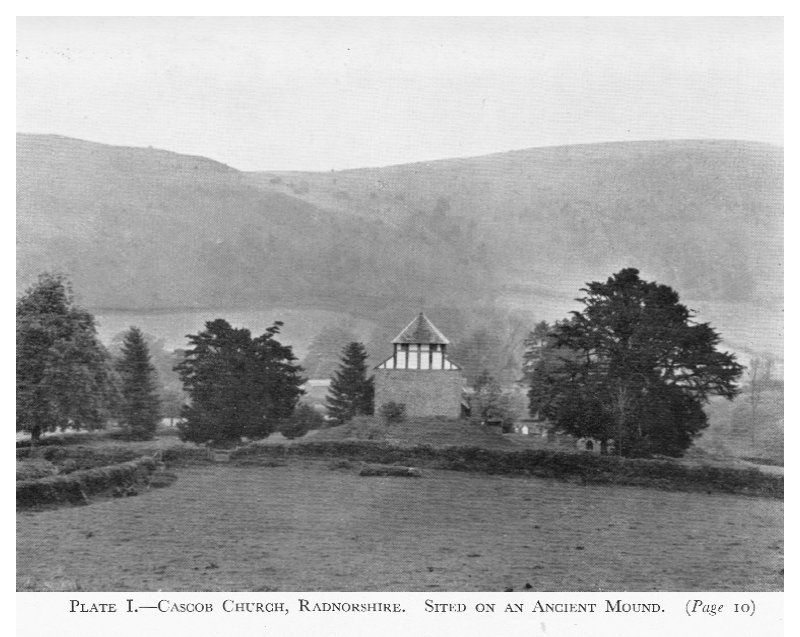
Features which Mr. Watkins includes in his “mark points” are: the earthworks, which we commonly call “camps,” often surmounted by clumps of trees, such a prominent mark on the landscape in many areas; stone circles, of all sizes; ancient standing (or “long”) stones, as well as stones of the rough boulder type; and mounds and barrows, on which one may find churches built (Plate I). Churches are not infrequently found built close to an old stone, the most remarkable instance of which, that I know of, is the church at Rudstone, in Yorkshire (Plate II). In quite a number of cases churches have been found (by excavation) to be founded on old stones (e.g. Twyford, near Winchester). Mr. Watkins adds in his list of marks ponds and “moats”; but I have not gone into the incidence of these on the alignments, as they are {11} uncommon in the south-west of England, where most of my own research has been made. But, elsewhere, other students have found them often on the alignments.
There is no time, or need, to go into detail about the connection of the sites of old churches with the ancient “pagan” sacred sites, but it is enough to say that Pope Gregory issued an injunction to Bishop Melitus, in England, to build Christian churches on the sites of the pagan temples, meaning thereby, presumably, the sites of stone circles; and edicts of the Church were issued forbidding the worship of stocks and stones, etc., and enjoining that those stones “which stand where four ways meet” (as sometimes they still stand, in mute evidence of the general correctness of Mr. Watkins’ ideas) were to be thrown down and hidden where “the foolish could not find them,” or words to that effect.
This last injunction was repeated by King Canute; so that we see that stones, etc., continued to be regarded as holy, or sacred, long after the introduction of Christianity into these islands. That these injunctions were not entirely successful in eradicating the reverence felt for the stones is shown by the fact that a certain stone in Cornwall (known as The Wendron God) was, in coaching days, always saluted by the driver and guard of a passing coach, and was habitually used by a retired Wesleyan Minister for purposes of prayer. That man could sense the sanctity in the stone—the power of the ancient worship. Stone holds this sanctity indefinitely.
The efforts of the early Christian Church to wean the people from their old beliefs connected with the stones (not all of which held uncontaminated influences) are shown in the “Christianized” stones, where a Cross has been incised on them to convert them in the eyes of the people. There is a curious instance of the survival of what may be called “folk-memory” in a churchyard not far from London (at High Beech, in Epping Forest). A granite stone, for all the world like one of the ancient Dartmoor longstones, was put up, as late as the period of the War, as a family memorial by a clergyman of the Church of England.
{12} There are a number of churches found standing inside the ancient earthworks. This may, perhaps, be regarded as a fulfilment of the Pope’s injunction to build churches on the pagan sites, for, to me, the earthworks (or at any rate a large proportion of them) occupy sites which were, originally, places of the ritual of the ancient worship of the sun—whatever purposes they may have become devoted to in the process of time. The enclosures as we see them to-day have been adapted, perhaps several times, to more mundane uses. Their sanctity dates back almost “beyond Time.”
Mr. Watkins has quoted a remarkable saying, found in a Welsh dictionary, that: “The Sun goes down behind his ‘gaers’ (or, as we should say, ‘his camps’).” This seems to be a reference to a connection of the “camps” with the worship of the sun.
Incidentally, the word “camp” has not necessarily a military meaning—a defensive place. My dictionary (Webster’s) gives some interesting meanings, e.g. “camp = to contend in athletic contests, especially to play the game of Camp. Also = a heap of vegetables covered with a mound of earth, as for winter storage; also, the mound itself.
Does the word “camp” as applied to earthworks simply refer—originally—to the ramparts? In this latter connection we have also the suggestion (made by Mr. Watkins) that the word “castle,” so commonly used for an earthwork, as “Woodbury Castle,” is simply a shortened form of “cast hill.” The expression “to cast up” is merely archaic English for “to throw up,” as for earthen banks or ramparts.
Another old meaning of “camp” is given as “a place for assembling cattle or other animals.”
One can add to the sites already included amongst those of ancient (in the sense of “prehistoric”) sanctity, the old stone crosses to be found in all sorts of places, and very common in the south-west. Several writers have expressed the belief that some of the stone crosses on Dartmoor are hewn from prehistoric standing stones—their outline seems to show it. So, following Mr. Watkins, I take the old stone cross to be the successor, in situ, of the earlier standing stone, or of the stone itself (Christianized), and expect to find them {13} standing on the alignments, as indeed they do. Some of the crosses on Dartmoor also bear an inscribed cross, and this may represent the first stage in the conversion of the old stone.
Let us look at the actual alignments. Naturally, church sites being so common, we might expect to find them the commonest features on the lines. In practice one cannot work (for “exploration” purposes) at a scale larger than one inch to the mile, for lack of area on any one sheet. {Figure 1}
Figure 1 shows two alignments, in Somerset; one, a line of six churches and an earthwork, in about 15 miles. The earthwork is Cadbury Castle, well known as the supposed Camelot of Arthurian legend. The other line is of five churches in about 13 miles. The two alignments cross at a church. This crossing of alignments, two or more, at a mark point is a very common feature in this investigation, and at the very outset starts in one’s mind a doubt as to the origin of the alignments of sacred sites having been for the purpose of marking track lines. Two crossings at a point—yes; that is easy; but more than two needs explanation. Mr. Watkins gave a speculative explanation of this phenomenon, but in my own opinion it hardly holds good. {14}{Figure 2}
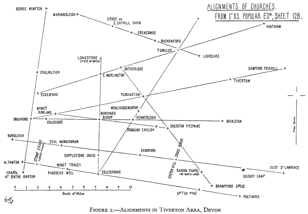
{15} Figure 2 shows a plan of the Tiverton area, in Devon. In it are shown only a few (eleven or so) of the alignments which it is possible to draw on this single sheet of the 1-inch map. In actual fact, one can draw on this single map sheet no less than fifty-five such lines, each of them taking up not less than four sites of the sort which we are considering, but mainly churches. I may say that, when one is looking for alignments of sites, it is a rule not to accept as “good”—on a single map sheet—any line of less than four, as three may be due to “chance”; at the same time, if three sites fall into a line on a map sheet, it is quite possible (and experience tells one it is quite probable) that other sites may continue the same line on an adjacent sheet. To extend a line from one sheet to another with accuracy is not quite as simple as it sounds, and may become very laborious. This labour is, perhaps, a reason why not very many people are inclined to try out this theory for themselves. But if more than two alignments pass through a common point (as in certain cases on this map sheet) it is fair to regard any one of such lines as may consist of three points only, as being equivalent to a “four-point” line. The mere fact that one of the three points is at the crossing of three or more lines, removes, I think, the matter from the realms of “chance.”
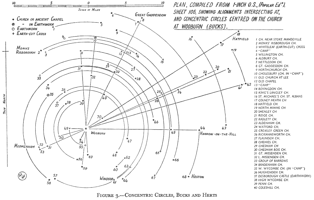
Figure 3 is a diagrammatic plan of the 1-inch sheet of the Watford area (1-inch O.S. Popular—or fourth—edition). As I have no local knowledge of this area it is always possible that some entirely modern church site may have found its way into the scheme; but I doubt it. One has visited many churches, interest in which has been aroused from the map, and found that they are of old pedigree. The modern site also may be at a cross-way (where, we are told, standing stones used to stand), and so, though quite modern itself, it may point to an ancient sacred site. This idea is, of course, dangerous, and not to be relied on as evidence.
In this diagram there are eight alignments which intersect at the old parish church of Wooburn, in Bucks. Strange, indeed, if these alignments of sites were set out originally to mark the way for travellers, that they should intersect at a single point; and this phenomenon may be found on {16}{Figure 3} {17} almost any map sheet. There surely must be an explanation, but I doubt if it lies in tracks. There might, of course, have been as many as eight tracks converging on a single point; but, as in this case, some of the alignments run right through it. Note the arcs, centred on Wooburn church, which show how two (or more) churches and other sites of the sort which come into our picture lie equidistant from Wooburn.
In this diagram there are two earthworks in which stand churches, viz. West Wycombe and Cholesbury.
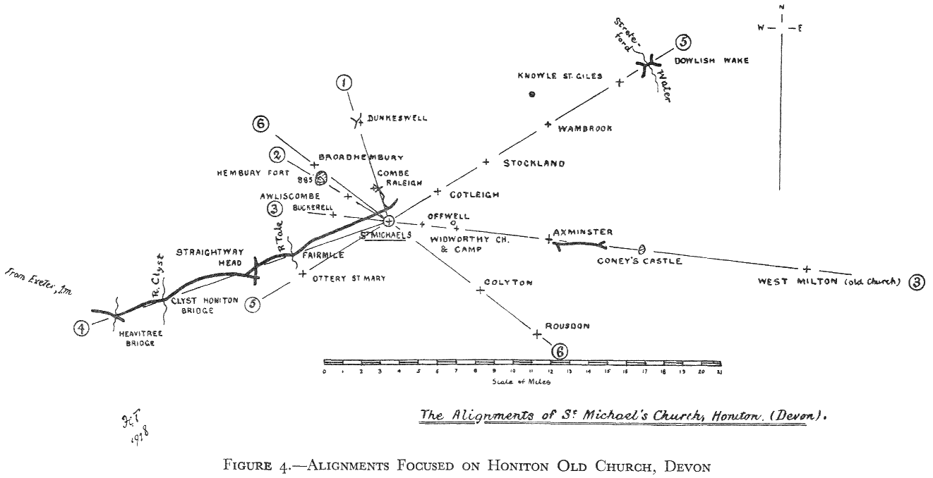
In Devon again (Figure 4) there are intersections at the parish church of Honiton, on high ground, outside of the modern town—“St. Michael’s” church—as so frequently dedicated where the site is high, and old. St. Michael often has his shrine on the top of a rocky and prominent hill, both in this country and in France, and Eastern countries have shrines in similar situations. We all know St. Michael’s Mount in Cornwall and its opposite number on the coast of Normandy. In Cornwall there is a place called Roche where St. Michael has his ancient chapel, built in such a position that a ladder is (now) necessary to reach it, a remarkable instance of a granite Tor standing solitary with a chapel at the summit, surely chosen for the site of a chapel because of its ancient connections with what we speak of as “Sun Worship,” which conferred the ancient sanctity on the site—perpetuated into Christian times. I am told that in Wales there are a very large number of St. Michael’s churches standing in earthworks—as many as a hundred, according to a reliable witness. If these high earthworks were not originally places where the old worship was ceremonially followed, then why should these churches have been built in them?
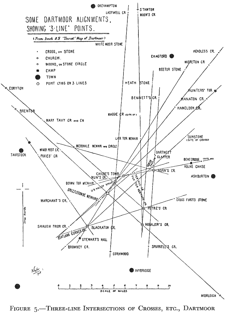
Dartmoor, in Devon, is particularly rich in stone remains, and Figure 5 (from the 1-inch map) shows some of the alignments of Standing (or “long”) Stones and stone crosses on the Moor. There are many alignments of this sort there; but I have confined myself to showing in this diagram only those on which occur intersections of at least three lines at a single site.
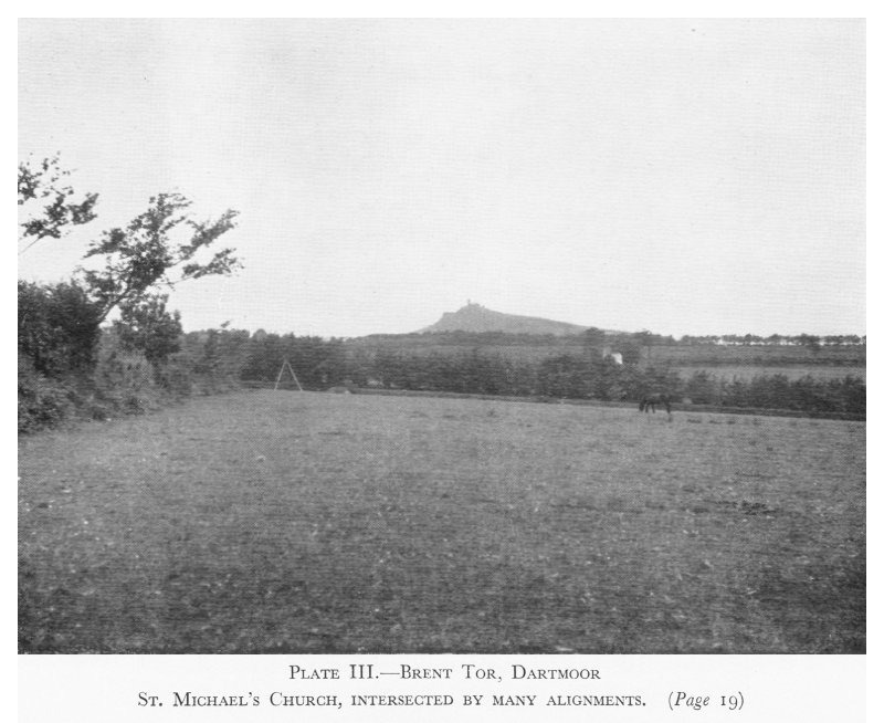
Mr. Watkins considered that high points were used as {18}{Figure 4} {19} marks on which to sight the alignments, though he did not consider that his tracks necessarily ran the whole distance. {Figure 5} That high points (often regarded as ancient places of worship) should have been used as guides for wayfarers seems quite natural (Plate III). Any point such as this very small church on the top of its conical hill would not have {20} been an exception. This is Brent Tor, on the western side of Dartmoor. It is surrounded by an earthwork, low down and not too visible. It is a well-known “St. Michael’s” church, with the very common story of a contest for the site between St. Michael and the devil. The Archangel won and claimed the church for his own, by dedication—the devil was driven away by the rock the Saint threw at him. Michael and Arthur are both connected, in Dartmoor legend, with rock-throwing contests with the devil.
Brent Tor is a great centre for church site alignments; a number cross here. But this is a little difficult to understand if the original lay-out was for tracks. How should they, to the number of seven or eight, intersect at this one spot, and that spot the top of an apparently natural hill of lava (as I read)?
One can hardly look at the church of Walkhampton, on the opposite side of the Moor, and half a mile from its village, with Brent Tor showing conical in the distance, miles away, without feeling that the two are calling to each other, an impression emphasized by the fact that an ancient cross stands at a cross-way in direct alignment between the two.