
Law sites and gallows hills • Two long lines • Graves and moot-places on the lines • Hermann (Arminius) and the Herlingsburg • Alteration of old place names • Dating methods must be revised • Sound signals
The persistence of the old law sites, which retained their character all through the great revolution in Carolingian times, is probably admitted by all. The people, from whom almost everything that they valued had been taken away or at least transformed – even the ground they stood on through the introduction of the feudal system – would not tolerate losing the old customary places of justice. A considerable number of the Galgenberge [gallows hills] will be traceable back into Germanic times.
| 30. | Lookout at Asse (south-east of Wolfenbüttel) — 39½ km — dev 0.4° hill chapel near Ottbergen monastery — 7½ km — gallows hill lookout near Hildesheim — 11½ km — 0.25° LT Konradisturm — 7½ km — dev 0.6 ° Wittenburg church — 4½ km — dev 0.05° Königskanzel hill above Barenburg — 18½ km — dev 0.16° abbey church at Fischbeck — 19 km — dev 0.3° Stöckerberg, cairn burial TP 240.5 m — 11¼ km — dev 0.5° Valdorf church — 20 km — place of sacrifice at Engern — 19½ km — dev 0.65° LT Beutling (north-west of Borgholzhausen) — west point. |
This line seems to belong to the small number of major signal lines, which show their traces across the whole territory of the Saxon federation. I have been unable to attribute the orientation in the Hildesheim region to a coincidence, although here again some places where the line crosses mountains remain quite unresolved. Even if such a phenomenon existed in isolation, it would remain a riddle. I have also included the confused and very incomplete part of this line from Fischbeck westwards, because I can report an event that makes it more probable, and through which my theory proved itself for the first time as a method for finding unknown sites. On this stretch there was a place that because of its high situation must unquestionably have been a beacon site. It must have stood on one of two equally high points of the same ridge, the Wirksberg or the 240.5 m height on the Stöckerberg. I requested a young archaeologist living in the neighbourhood, Herr Meier-Böke [224.a], to visit these two points and see whether anything was to be found on the precisely defined east–west line. The report that he sent back to me runs: “Now for the surprising thing: 60 m due west of the 240.5 height, measured from the TP stone, which stands near the Hesse–Lippe boundary stone (date 1669), there rises a cairn beneath the line. Unfortunately it is 3/5 gone; farmers or others have used it as a quarry; it is a pure burial cairn, situated higher than the two and on 253.6 m. About 11/3 m high in the remaining highest point. Diameter = about 14–15 m. A stupendous collective achievement of the early Bronze Age. Both the compass and the × on the TP showed good orientation, deviating perhaps somewhat S of E–W.”
I then visited the spot with the finder and School Inspector Schwanold, who confirmed Meier-Böke’s opinion. The importance of such burial finds on sites beneath our lines, where there must have been sacred watchpoints, is shown by the following line, all of whose points I will name, even if there is nothing to be said of some of them except that they lie exactly on the line.
| 31. | Marienfeld church (north-west of Gütersloh) — 8 km — Isselhorst church — 12 km — Kraksalso spelt Kracks church — 4½ km — burial mounds on the Bartelskrug — 3½ km — dev 0.4° Hünenkirche [giants’ church] in the Tönsberg camp — 1½ km — Ückenpohl — 1½ km — dev 0.1° Stapelage church — Hiddentrup — 3 km — Pivitsheide cemetery — 2 km — Schwarzen Brink (burial mound) — 8 km — Hohenwart near Detmold — 3½ km Niederschönhagen — 1 km Flötpfeife 207.2 m — 2 km Mossenberger Himmel — 2½ km Istrup cemetery — 3 km “Altblomberg” — 5½ km Gross Heimberg — 1½ km — dev 0.05° Herlingsburg, TP 334.6 m in the camp. — east point — total distance 63 km — dev between Hünenkirche and Herlingsburg 0.05°. |
The north line from Isselhorst was already known to us from our Example 8. Here we have one of the east lines, which is to be reckoned among the long-distance lines and stands out clearly because of very numerous notable intermediate stations. It would in itself furnish ample material for a separate essay. I should here like to go into some of the thoughts that it provokes.
The Herlingsburg, on a hill whose shape makes it a local landmark,
is shown in
Fig. 74,
after an old drawing.
 Fig. 74
The role of the camp as the residence of Hermann (Arminius) is not limited to tradition,
and Wasserbach makes it the place where a statue of the liberator of Germania stood.
That he confuses the statue (for which, by the way, there is more than a little evidence)
with the Irminsul – the world pillar, which supports all that exists – is understandable,
in view of the name and the obscurity that hangs over these affairs.
Also, the fact that Charlemagne devoted particular attention to this region, and in 784 spent several
months in Lügde, turns it from a conjecture to a near-certainty that Lügde with the Herlingsburg
was the former capital of the Cherusci territory, just as Paderborn (formerly called Teuderi)
was once, and again later, the federal capital.
I agree with Schuchhardt’s opinion that the Germanic princes did not live on these fortified hills,
but on the great lordly estates associated with them, in this case probably the Domäne in Schieder.
Here Hermann may have had his allodial property.
Fig. 74
The role of the camp as the residence of Hermann (Arminius) is not limited to tradition,
and Wasserbach makes it the place where a statue of the liberator of Germania stood.
That he confuses the statue (for which, by the way, there is more than a little evidence)
with the Irminsul – the world pillar, which supports all that exists – is understandable,
in view of the name and the obscurity that hangs over these affairs.
Also, the fact that Charlemagne devoted particular attention to this region, and in 784 spent several
months in Lügde, turns it from a conjecture to a near-certainty that Lügde with the Herlingsburg
was the former capital of the Cherusci territory, just as Paderborn (formerly called Teuderi)
was once, and again later, the federal capital.
I agree with Schuchhardt’s opinion that the Germanic princes did not live on these fortified hills,
but on the great lordly estates associated with them, in this case probably the Domäne in Schieder.
Here Hermann may have had his allodial property.
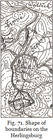
Again, the fact that the Herlingsburg is the meeting-point of three districts, as already mentioned in the Köterberg example No. 5, rules out that it was ever, while such property relations prevailed, a residence. The exact configuration of the boundaries can be seen in our map extract on page 215. The reason why the Pyrmont district has retained this economically useless and inconvenient, but militarily quite absurd, tube of territory with the hollow way right up to the highest point, can only have been an idealistic one. The holy orientation line between the Herlingsburg and the Hünenkirche (whose position on the long ridge of the Tönsberg is defined by the Herlingsburg) establishes for us the cultic importance of the Herlingsburg, as we have also found it for the Teutoburg, the Köterberg, etc. To the Herlingsburg there is joined a “Spielberg”. That this camp also was useful to the three districts as a assembly-place for military forces, as a stronghold in time of need, and probably also for other public purposes – as evidenced by the traces of all kinds of occupation that have been found there – all this, in view of the former close connection between religious and other public life, can be taken for granted. We may leave open for future consideration the question of whether this hill was modified like many of the examples presented by Willy Pastor (such as the Walburg near Obergänsendorf in Austria).
The altitudes of the two main points, the Hünenkirche and the Herlingsburg, are 332.0 m and 334.2 m, and thus almost the same. Since the high spots in between do not reach this altitude, direct communication by fire signals would be possible in good weather across the 34 km between these two major sites. But in case the air was less clear there would have to be intermediate stations there. (The altitude given in Fig. 71 is a misprint on the official map.)
If now a line shows, as does the foregoing, a large number of intermediate sites which go beyond this requirement, and whose sites were unmistakably chosen on purpose beneath the line, then from this we can once again recognize the strong preference, based on religious feeling, of the ancient people for these holy lines, and their strong attraction towards them.
It is as if the ancient peoples, before making a definite choice of a site that was important to them, first consulted with one of the priests who were familiar with the practice of orientation. For even the position of these intermediate stations generally deviates, as far as we can check it by mapwork, by only a small amount from the line passing over it: mostly by less than 2 mm on the official map (= 50 m on the ground) – provided a survey point is available. That is an accuracy which could not be achieved by an untrained person even a few kilometres from the other survey point. In most cases, in fact, to achieve such accuracy it was imperative to have an agreed system of signals with a second fire-warden, who could make himself conspicuous behind the other survey point.
The preference for going back to the holy lines not only had its effect on the layout of assembly-places, but also often played a part in choosing the burial places of eminent people. We can see it on this Tönsberg line at two sites, in a way that I have also noticed elsewhere. On the Bartelskrug, successful excavations were carried out very recently. On the Schwarzenbrink, both Wilhelm Tappe’s 1820 map of graves and the official map show burial mounds. I found at the top of the hill, where the marker will have stood, a hole that again suggests a torn-out foundation wall and is otherwise hard to explain.
The Christian custom of burial near the church, or for people of high enough rank in the church, is probably a direct continuation of an old Germanic preference. Again, the Pharaohs in Egypt and others sought their last rest with the deity in his sanctuary.
My success on the Stöckerberg near Langenhlozhausen (Example 30) was repeated on the Saalberg near Alverdissen (cf. Example 3), where under my direction we looked for traces of a former orientation marker. In the farmland that now occupies the hill there was nothing to be discovered, and the actual beacon that must have stood here seems to have completely vanished; but lying on the line, and hidden in the copse, was found a partly layered, partly heaped-up cairn, which seemed to be a burial cairn; its significance has still to be investigated.
All the same, it is probably an erroneous assumption that the development was from
burial place to cult place; more likely it was the reverse.
But what is most likely is that each was born with the other, as a world beyond revealed itself
to the human spirit. Graves can sometimes become signposts to the sites of cult places!
With the exposure of this error such wonderful old Germanic memorials
 Glaner Braut
as we see e.g. in the Glaner and Visbecker Braut
and the Visbecker Bräutigam, acquire their full high meaning.
We learn to see them as they really were, as strongly enclosed memorial places,
which were already sanctified as religious cult places for sacrifice and jurisdiction;
and just for that reason graves too are found in and around them!
Thus my remarks about the hill sanctuary in the Oesterholzer Mark are also confirmed by
lessons learned from the study of orientation phenomena.
The Stonehenge question and all similar questions should be treated and answered from this viewpoint.
We must learn to think more and more of the fact that
our forebears first of all lived, ruled and worked, believed, sacrificed and prayed,
and only then died. (Cf. Prof. Hahne, Totenehre.)
Glaner Braut
as we see e.g. in the Glaner and Visbecker Braut
and the Visbecker Bräutigam, acquire their full high meaning.
We learn to see them as they really were, as strongly enclosed memorial places,
which were already sanctified as religious cult places for sacrifice and jurisdiction;
and just for that reason graves too are found in and around them!
Thus my remarks about the hill sanctuary in the Oesterholzer Mark are also confirmed by
lessons learned from the study of orientation phenomena.
The Stonehenge question and all similar questions should be treated and answered from this viewpoint.
We must learn to think more and more of the fact that
our forebears first of all lived, ruled and worked, believed, sacrificed and prayed,
and only then died. (Cf. Prof. Hahne, Totenehre.)
The rolling centuries, along with extremely unfavourable circumstances, especially the determination of those who saw the destruction of Germanic culture as a precondition for fundamental romanization and christianization, have admittedly left almost nothing tangible for research into our Germanic past, apart from graves and still more graves and wretched remains of walled camps and settlements. These last are wretched because there is mostly nothing to see in what we find but the settlements of the unfree lesser people, while the stately residences of the truly free people – as has already been mentioned above – have been overbuilt by succeeding generations and thus have nothing left to offer us.
Thus it is that great astonishment results, when a chance find opens our eyes for once and shows true state of culture among the ancients.
On our Tönsberg line there appears very distinctly the hill called Mossenberger Himmel [Heaven], which even in its own region has faded into obscurity. Only among the people living close by is it still the subject of legend. Representations of Heaven and Hell (with Hell thought of only as the underworld, not as a place of punishment) were, albeit in many different forms, the common property of ancient peoples.
I have visited the spot and believe that it cannot fail to make an impression on anyone who has tried to immerse themselves in the intellectual world of the ancient peoples. With considerable effort a small valley, horizontally about 40 m broad and 150 m long, has been dug out of the hill, broadening the course of the spring. The spring gushes out at the end of a small valley, surrounded by high ground and overgrown with bushes, and is there widened into a pond. The horizontal area on the side of the hill is used as arable land by the present occupier, despite the damp situation.
That then was one of the places where our forebears symbolically portrayed the entry of the soul into the beyond! Whether the other three or four places in this region with similar names make the same impression as the Mossenberger Himmel, I will not try to discover. The holy orientation line crosses over the upper part of the Mossenberger Himmel. Similar places with similar names are to be found throughout Germania.
Preuss, who in the early 1890s won great credit by collecting the field names of the Lippe region, was limited by the materialistic trend of scholarship in his time. And he knew nothing whatever of a Germanic intellectual life in the pre-Christian period which could be related to the place-names of this region. But since as a matter of fact such relationships abound here, it is startling and sometimes amusing to read the attempts made in those days to avoid recognizing such relationships. On the names with Himmel [Heaven] Preuss knows no better than to remark: “for some of these places we are perhaps justified in assuming a reinterpretation of ‘Himbeere’ [raspberry]”!
This Mossenberg in 1488 was still called “tom Ossenberg”. Even Preuss sees that here he is forced to concede a connection between the family name Osing, from which he derives the name of the hill, and ans, as, os = god. There is also in this region an Asenberg, an Asemissen and Assemissen; a part of the Teutoburg forest range is called “Osning” = Asen ridge. On “Ösenberg” with the same etymological meaning Preuss guesses: “Perhaps because of its ring [öse] shape”! Amazing! That must be the last word in desperate, impossible, inane interpretations.
One may ask: are we then to believe that our forebears were dumb dogs, who gave their hills and places no names? or that on the introduction of Christianity the people suddenly threw overboard all their old familiar place names and replaced them by new ones? That is quite impossible, even though the priests and monks did everything they could at the time to mutilate and wipe out names that led back to the cult of the gods. The reason for that lay in the method by which Christianity was introduced into Germania from the time of Charlemagne onwards. We must and will speak of it, relentlessly. In stark contrast to the original spirit and teaching of Jesus Christ, the Roman Church of those days went back, in everything that seemed useful to strengthen it and spread its power, to the attitude of the Old Testament. The subjection of Germania to the Church followed to the letter and agreed in spirit with the order that is given in Deuteronomy 12:2,3:
“Ye shall utterly destroy all the places wherein the nations which ye shall possess served their gods, upon the high mountains, and upon the hills, and under every green tree: and ye shall overthrow their altars, and break their pillars, and burn their groves with fire; and ye shall hew down the graven images of their gods, and destroy the names of them out of that place.”
Yes, thus it is written: even the names are to be wiped out! Where churches, monasteries and chapels were sited on the old sanctuaries, the previous place-names were cast aside in large numbers. They were replaced by preference with names referring to saints. But where it was not acceptable to give the places a Christian stamp, and where the previously-mentioned satanization failed or was unsuitable, an attempt was made to alter the names or their meaning over the course of time. It is a wonder that there are still so many names left in which we can rediscover connections with the Germanic past.
When the surviving old names, whose cultic significance had gradually sunk into oblivion, were written differently or otherwise changed by the literate class, the common people gradually came to believe that educated people must know best and be in the right with their way of spelling, and that they themselves with their accustomed way of speaking were wrong. As it happened e.g. with a “Hühnerberg”, which will have been called “Hünenberg” [giants’ hill], or the above-mentioned “Köterberg”, so it must have happened with countless other names, the more so as the deliberate intention to alter of the early days was replaced by utter lack of comprehension on the part of educated humanism, and unwittingly gained an ally.
An example from recent times of the suppression of an old name, which probably results from the desire of educated gentlemen to look clever, is one that I encountered a short while ago, when I was looking for the massive and well preserved foundation walls of the ruined castle at Todemann, which on the official map of Rinteln are recorded as “Frankenburg” [Frankish castle]. When I asked the farmer living less than 100 m from the spot the way to the “Frankenburg”, he looked at me doubtfully for a while and said: “Do you mean the Hünenburg?” – That is a falsification of tradition! I was ashamed, for I had perhaps helped to make the farmer believe there really was a “Franken”burg, its name was that, and he must now so call it. I regret it all the more because – having reached the summit and standing before this superb, cleanly excavated and almost unbroken outline, – I remembered the excavation of the camp by my old acquaintance, the late Sanitary Inspector Weiss, and had to think of the completely inadequate grounds that had relabelled this castle as Frankish – mainly because of ceramic and other finds, which resembled objects in our museums that are labelled “Frankish” too.
Schuchhardt lets the Hünenburg keep its good old name. He appears to lay great emphasis on a small room attached to the castle wall, less than 15 m2 in area and with a 1½ m wide “apse”. He explains a cylindrical pit, situated at the side of this, as a piscina sacra “for the fallings from the altar” and calls the instance an unusually early one. If this could have been a Christian chapel at all, it is most readily explained by assuming that it was built afterwards. In no case do either the finds or the building itself provide any evidence that this Hünenburg was not already in existence in the pre-Christian period. In particular, the mention of lime mortar as evidence against pre-Carolingian origin must of course be rejected. We have already discussed, in the section on the ruins at Kohlstädt [230.a], what a crippling effect such hypotheses, based in a purely negative spirit on inadequate assumptions and uncertain dating of finds, must have on research into the Germanic past.
It is the same with the “Hünenkirche” [giants’ church] that lies on our line
in the Tönsberg camp.
 Fig. 75
It has kept its old name without competition, but it is built using lime mortar
and is supposed to have originated entirely as a Christian chapel, although its building style
rules out such an assumption and the camp had to be dated
at least
on the boundary between the Saxon and Frankish periods. The reader is referred to
Fig. 75,
which shows the altar wall.
The large doorway, later walled-up, is a quite impossible phenomenon for an altar-room.
Moreover, the necessary symmetry of the chancel is lacking. On the outside are supporting pillars,
but they were stuck on afterwards, to create the appearance of a Christian chapel.
The beginning of a vault is noteworthy as a witness to the orderly and necessary train of development
which after several centuries led to the masterpieces of cathedral vaulting.
In front of this room lies a second room of the same size – an unacceptable ground plan
for a Christian place of worship.
Fig. 75
It has kept its old name without competition, but it is built using lime mortar
and is supposed to have originated entirely as a Christian chapel, although its building style
rules out such an assumption and the camp had to be dated
at least
on the boundary between the Saxon and Frankish periods. The reader is referred to
Fig. 75,
which shows the altar wall.
The large doorway, later walled-up, is a quite impossible phenomenon for an altar-room.
Moreover, the necessary symmetry of the chancel is lacking. On the outside are supporting pillars,
but they were stuck on afterwards, to create the appearance of a Christian chapel.
The beginning of a vault is noteworthy as a witness to the orderly and necessary train of development
which after several centuries led to the masterpieces of cathedral vaulting.
In front of this room lies a second room of the same size – an unacceptable ground plan
for a Christian place of worship.
Needless to say, the late dating of the Hünenkirche once again rests on a few finds. As if there could not take place on Germanic territory and in a Germanic population, either through international exchange of technical knowledge or through commercial traffic in various commodities, the same development as on Gallic territory! And if the Frankish or Merovingian forms etc. in their turn show Roman influence, it is exactly the same. Nothing whatever stands in the way of this idea except the objection, so admirably castigated by Kossinna, “repugnant to cultural history”, to use the classic expression of Matthias Koch (see p. 11) [231.a]. There is no more urgent need for archaeologists than to tear up the weed of this “repugnance” down to the last root-hair, and replace it by a trustworthy objectivity. Otherwise it is inevitable that alongside our professional archaeology, which sticks to its “Merovingian” or “Frankish” potsherds, another archaeology will arise, which is sick of this “repugnance” and will not forget that besides objects found in the soil there are and have been many other things in the world.
It may be that I shall get abuse for it from certain quarters, but I repeat: It is high time that the conventional dating principles of archaeology were submitted by their proponents to revision from another point of view. Let it be enough to evaluate, define and order finds purely objectively in the first instance, according to their nature, their characteristic properties, and their context; to arrange them and record them in groups with objective and as far as possible neutral names – as indeed is already being done for some groups. Above all let those groups whose dating is the most important to us (those for the period from the birth of Christ down to the high Middle Ages come into question) be freed from hastily-given historical names! For these create prejudices in the cultural history of this period which rest on untenable, sometimes extremely slender foundations and exert a misleading and directly harmful influence on cultural history.
I am glad to find that in Grundfragen der Urgeschichtsforschung [fundamental questions of prehistoric research] by K. H. Jacob-Friesen, a warning voice is clearly to be heard in this connection. So I find myself in good professional company.
And the preceding times? For the narrow circle of professionals such feeble names as “La Tène” and “Hallstatt” may serve their turn; but should wider circles really accept them as final? People say “Roman”; it is time that aspects of Germanic culture were called “Germanic”.
It is just in rapidly progressing archaeology that care must be taken to avoid being left rusting in an outdated framework. Cliquish restraints and attachments should be torn away, as Kossinna once did. That however was long ago. We should like to live long enough to see the next step.
An extremely striking name on the Tönsberg line is “Flötepfeife” [flute-pipe] as the name for a point in the landscape where there are now two houses. If it seems self-evident to us that, from the watch-place appointed for fire-signals, at the same time sound-signals were emitted for the people living nearby, then there is little danger in assuming further that the watchers of these stations once used to communicate with their people by means of pipes.
The Flötepfeife name reminds us of Example 17 with its Sackpfeife [bagpipe]. No doubt all kinds of explanations are current for this most peculiar name of the highest hill (647 m) of the Sauerland. But the correct explanation, which is consistent with the former importance of the hill as a cult and signal place, will have been carefully eradicated many centuries ago. However, our idea is that the ingenious signal-watchers of this place, in order that they might also emit sound signals from the high hill, resorted to bellows as an aid whereby they could emit siren notes with a much greater range. – As regards previous explanations of the name Sackpfeife, there is nothing to be learnt even from Hessler and Schneider [232.a].
Next, attention is drawn to the two points “Hohenwart” and “Alt-Blomberg”, where now in the landscape there is nothing to be found, not even the holes of the former markers. But the name “Hohenwart” [high lookout] – now the designation of a few houses – speaks for itself. As regards Alt-Blomberg [Old Blomberg], we may undoubtedly see in this field name, which now denotes merely a cultivated spur of the hill, a piece of fossilized history. It is obvious from looking at the place with this name why the present small town of Blomberg with its castle has no part in the old orientation network. The find of a stone axe in the Alt-Blomberg area also serves to confirm that the place was settled in the earliest times.
Apart from the names by which a place was meant to be brought into disrepute, including all the Devil’s and witches’ places, and perhaps also “Lause”berg [louse hill] and the like, we have to consider names which, as it seems to me, referred to the shape of the marker, such as Kruke [pitcher], Stucken [tree stump], Pahl [pole], and also, according to my interpretation given above, Thören, Dören = tower; further, names connected with the old gods, such as Köter, Asen, Donner, Goden or Guden, Frigg or Frei. Köterberg can not arise from Götterberg [hill of the gods] in speech, but we may assume instances have been deliberately altered from “God” or “Wod”.
That only some of the countless “Oster” places have something to do with the simple cardinal direction east [Osten], while the others are either connected with the cult of the goddess Ostara prevalent in the late Germanic period, or else with the Easter fires and festivals which are to be regarded as a relic of the Ostara cult – about this there can probably no longer be any difference of opinion. But these “Oster” places are so numerous that they can only in exceptional cases be useful to us in our orientation enquiry.
As examples of lines that offer noteworthy and objectively important points as well as names, I should like to take two from the Oldenburg district, where there is also a fertile field of research for the archaeologist in other respects. Having been called in by the respected Bremen merchant Adolf Held, whom death has since taken from us, I found 3 years ago in the “Loh”, 1½ km west of Dötlingen, namely in the Poggenpohlsland north of the Goldberg, a large field with the remains of many stone circles (Troytowns), whose contents still need to be recorded before they completely disappear as building material.
| 32. | Wachtberg TP 50.0 m — 10 km — dev 0.05° Dötlingen church — law site — Aschenstedt — 9 km — dev 0.1° Wunderburg (circular earthworks) — school at Seelte (no church) — 11 km — dev 0.2° Barrien church — east point. |
| 33. | Goldenstedt church, Osterhorn — 16 km — Hünenburg [giant’s castle] (circular earthworks) south-east of Twistringen — Wehrenberg — Klageholz — Lichtenberg — Bücken cemetery — horst (naturally raised block) between Altenburg and Donnerhorst — Klotzeburg — total 50 km — dev 0.3° Kirchwalingen church — 6½ km — dev 0.15° Bierde church — Karlsberg — east point. |