
Lines in Silesia • Trig points and spot heights • Licht and Leuchten names • Lines in Berlin and other parts of Germany • Hints for research • Conclusion • A prize competition
My researches had so far been based on limited regions of western Germany, especially Lower Saxony. But a few glances at other parts of Germany show that the old orientation can still be proved in regions of eastern Germany. Even here it can be seen that the Slavic incursions into eastern Germany, which make the assessment of the old Germanic settlement patterns so much more difficult, have not entirely been able to efface the traces of an orientation which is completely identical to the orientation in western Germany.
It is a particular pleasure to read in Max Leichsenring’s work [233.1] so many irrefutable proofs for the purely Germanic foundations of culture in the kingdom of Saxony, where previous assessments had given the credit ad nauseam to non-Germanic peoples.
Considered from the same viewpoint, the extremely important researches of Erich Jung [233.2], on evidences for Germanic gods and heroes even in the Christian period, will help to exorcize from the good Germanic areas, on which his researches are mainly based, the spectres of alien cultural influences that have been so eagerly evoked.
Amid the towns and villages of Silesia, with their completely different layout from what we see in western Germany, and their Slavonic names, the many Germanic names, for the most part old ones, bear witness to a culture that is innately Germanic. Everywhere the Hain [grove] place-names, but also Weinberg and Lichtberg, Brand, Teufels and Höllen places, and then Wachtberg and Warteberg (insofar as the last two, because of their position, cannot be satisfactorily explained as medieval or later) remind us of a pre-Christian Germanic past.
As far as I know, there exist neither the remains of Germanic camps that could be used as a starting-point, nor again churches that are unmistakably on assembly places, because during the conversion of Silesia quite different patterns of population and culture prevailed there. This circumstance did indeed make research more difficult, but could no longer hold it back when I noticed in Glatz County two Wachtbergs astronomically sited on the north line. There was no way to explain the name of these lookout hills on these sites purely in terms of medieval needs, happenings or customs. Incidentally, a later use of the sites would of course not rule out their use at some preceding time. All doubt was excluded when, after I acquired the official map sheets of this region, there turned up on this same north line between the two Wachtbergs yet a third Wachtberg! Earlier opinion about the Wachtbergs was not to be found.
| 34. | Wachtberg near Droschkau — 3½ km — Wachberg south-east of Neudeck — 15 km — Wachtberg near Grochau — north point. |
On the Wachtberg near Grochau the lookout for the numerous “old entrenchments” around it, whenever they originated, must have stood on the 417.8 m TP. Five more trigonometrical points as intermediate stations show us very clearly the course of the north–south line as far as the middle Wachberg above the “grove” in the princely forest at Camenz (old Cistercian monastery dating from 1094.)
If this interpretation of the line is correct, then the beacon of the middle Wachberg stood on the summit of the mountain, 125 m south-west of, and somewhat higher than, the 510.6 m TP (dev 0.1°). Here, so I am told, can be found a semicircular meadow enclosed by stones, and in the middle of it a rough block. Then after 3½ km comes the southernmost of the three Wachtbergs, above Oberhannsdorf; I have received interesting reports about the pass here, where the lookout must have stood. The continuation of this line goes in a striking manner through the trigonometric points of Rosenberg and Sauerberg and seems to extend as far as the pilgrimage place Maria-Schnee. It also touches the Scheibenbusch of the age-old Scheibenhof near Kunzendorf.
Before investigating this region I had not given any particular attention to mere spot heights and trigonometrical points. But this last line, exceedingly obvious anyway on account of its three Wachtbergs in the short space of 19 km, also includes, as we have seen, nine trigonometric spot heights with striking exactness. So it seems a good opportunity for me to say something about the role to be ascribed to spot heights, when they turn up on the lines.
There are innumerable spot heights on our maps, any random line meets several, often many of them, so that at first I left them strictly alone as signs of very recent culture. But it was remarkable, all the same, that here and there they were positively intrusive, not only on the north lines, which I could understand, but also on the east lines. My enquiry at the National Survey Office, addressed to two survey directors independently, received almost identical replies: “If trigonometrical points have the same longitude or latitude, that is pure coincidence; it is never done on purpose.”
Since then I have no longer left such markings strictly alone. Even if, because there are so many of them, chance should always be assumed at first, there are still enough situations that require us to take notice of them. After some thought it should be possible to realize the intimate connection of modern surveying practice with those ancient sites with which we are concerned here. It is a smaller version of what we have already considered for lookout towers. Though the practical surveyor, when setting up his stone, is not at all interested in creating a north or east line, it is nevertheless more convenient for him to choose sites that provide a wide view and if possible are conveniently placed on a road, rather than going aside into the wood, or even crawling though the bushes. So the surveyor looking out for a suitable point hits, quite unintentionally, mainly on the ancient markpoints, which of course were all selected under the same consideration of open view, and which have often retained down the centuries their separation from the surrounding landscape and their means of access. Thus a spot height can often indicate for us the position of an ancient orientation marker.
There are still more Wachtbergs in Silesia.
| 35. | The Wachtberg near Eichau has at 3 km distance on its east line, at the top of the pass, the “Aspenwiese” [meadow] and 2 km further a Klapperkapelle [chapel] (dev 0.1°). |
The Aspenwiese caught my attention for other reasons too, which it would take us too far afield to explain here. It then turned out to be a nodal point of the orientation. The summit of the Wachtberg near Eichau is artificially flattened; some peculiar holes perhaps recall former buildings.
| 36. | The Aspenwiese has a Warthberg not only on its west–east line but also on its north–south line, namely the Warthberg which lies south of the small town Wartha and palpably shows its Germanic significance through its pilgrim chapel; then north of Wartha comes the extended layout of the rosary chapels, in the midst of which the 380.2 m TP can probably be seen as a markpoint of Germanic orientation. Whether in that case the Klapperberg lying 7 km south of the Aspenwiese should also be regarded as part of this line, would have to be checked; its TP lies 125 m west of our line and has no remarkable features. But its name perhaps indicates sound signals. |
The Annakapelle [St. Anne’s chapel] west of the Klapperberg comes into consideration, it seems to me, for an east line. An orientation of the Annawarte [lookout] in the Doym forest on north–south and east–west is admittedly evidenced on the map only by a number of TPs, but a visit to it for the sake of its name might be rewarding. Our undertaking requires visit after visit, even if most of them, for known reasons, must be fruitless.
Since all places with Leucht [light, shining] names arouse our interest, I must not pass over Lichtenwalde in Glatz County. The explanation “clearing in the wood” is so vacuous and improbable that we should only be satisfied with it if all else fails. A proper name is meant to individualize and distinguish. A name that merely expresses a concept applying equally to other places in the neighbourhood, is not a proper name. In such cases the explainer is always on a false trail. Let us see whether Lichtenwalde has not some other meaning.
| 37. | The 640 m height (marked on the map by four wayside shrines) above the forester’s lodge at Lichtenwald [light wood], where we have assumed there were far-shining fires in the Germanic period, gave the place its name! To the west there is nothing of note on the slope of the hill, but further along lies Stuhlseifen church exactly on the line; to the north there must have been several intermediate stations on the large mountain slope, in particular only 1 km away, where two footpaths meet on a parish boundary, and then not far from the Mandelfichte and 681.4 m height above Eilenburg and Stephansberg; if we then find Neuweistritz church 4 km further north, the layout of Silesian churches here – as at Stuhlseifen – once again becomes a pointer. In the easterly direction there is nothing remarkable. |
Before we leave Silesia and turn to other Leucht names, I should like to point out the relations
in the Breslau [Wrocław] district, about which I can speak only with strong reservations.
There is indeed no doubt that on the Zobten [Ślęża],
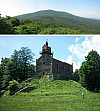 Zobten
with its hilltop church and its spring, there is a Germanic hill sanctuary.
Let us remember that the old Christian Church, influenced by the Old Testament,
was by nature thoroughly opposed to worship on high places,
which in Palestine was one of the abominations to be fought against.
Whether now the Wilhelmshöhe in the west, Grossburg with its quite remarkable church site in the east,
the Wachtberg near Cauth in the north, and the Geiersberg in the south may be counted as orientations
on the Zobten, will be decided by those with local knowledge [235.1].
Zobten
with its hilltop church and its spring, there is a Germanic hill sanctuary.
Let us remember that the old Christian Church, influenced by the Old Testament,
was by nature thoroughly opposed to worship on high places,
which in Palestine was one of the abominations to be fought against.
Whether now the Wilhelmshöhe in the west, Grossburg with its quite remarkable church site in the east,
the Wachtberg near Cauth in the north, and the Geiersberg in the south may be counted as orientations
on the Zobten, will be decided by those with local knowledge [235.1].
The position of the Wartberg near Keulendorf, 28 km west of the oldest (it seems to me) settlement site in Breslau, likewise led to the hypothesis of an orientation line; one might also ask whether Pohlanwitz and Hochkirch to the north and Mandelau to the south of this point serve to indicate a north–south line.
Among the Leucht names, Lichtenrade, Lichtenberg and Lichterfelde near Berlin draw attention to themselves.
| 38. | The site of St. Nicholas’s church behind the castle is stated to be the oldest settlement site in Berlin. While testing whether orientation phenomena would also appear in Berlin, it seemed exceedingly striking to me that the north–south line of St. Nicholas’s church hits Lichtenrade to the south; on the way a small ancient cemetery will come into consideration as an intermediate station. To the north, the line has in Schönhausen castle another remarkable point (distance 7 km, dev 0.1°). That after another 2 km the southern cemetery chapel on the Rolleberg falls on the line, may be due to chance; this could be clarified by looking into the history of the cemetery. Further to be noted are the TPs at 59, 60, 56 metres, and the Dammsmühle [mill]. All points have very small angular deviations from the north line of St. Nicholas’s church, as far as one can tell from the “Map of the Berlin district (State Survey)”. – At Lichtenrade the high point south of the church, rather than the church itself, is probably to be considered the site of the light signal; the deviations are in both cases very small (0.05° and 0.25°) on a distance of 14 km from St. Nicholas. In any case we have a remarkable phenomenon here. |
| 39. |
But now our attention is doubled.
On the east line of this same St. Nicholas’s church lie
Lichtenberg (cemetery chapel), Wuhlgarten church and Fredersdorf church!
The cemetery chapel in Lichtenberg stands on the Windmühlenberg [windmill hill], on which for some reason its site must have been particularly recommended. To the west, it seems to me, a whole series of points of public importance is touched on, some of them with interesting names, as far as Priort church; I must leave the assessment of them to those conversant with the history of Berlin. At this point I may recommend that even the most favoured and familiar explanations should be once again put under the magnifying glass, to see whether they are really adequate. Let it never be forgotten that even in pre-Christian times there were people living in the Mark of Brandenburg , who could speak, had religious needs, and organized all kinds of things. Ought not many names still bear witness to that? |
| 40. | Even the alleged connection of the name Lichterfelde with a Belgian town Lichtervelde (as a result of Flemish immigration), and of the Belgian name in its turn with lightermen, is in need of proof. At any rate the fact cannot be altered that the chief site in Lichterfelde (the church) can be found on the same north–south line as the church site of the age-old settlement at Hermsdorf and the old cemetery at Charlottenburg. |
The map of the Berlin area again offers a great many interesting orientation phenomena, among which Potsdam, Römerschanze, Babelsberg and a large number of outlook towers should not be ignored. As far as I can see at present, the Berlin area, even in the time when orientation began, was the setting for a culture that had grown up in close connection with western Germanic culture.
I quote a few examples from other regions, which I came across when the maps happened to be available.
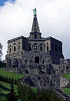 Hercules
monument
| 41. | Wilhelmshöhe, Hercules monument — 1¾ km — dev 0.05° LT at Elfbuchen ½ m — Hühnerberg — 3¾ km — dev 0.05° church in Weimar — north point. |
| 42. | Westerkappeln church — 2 km — dev 0.05° Gabelin (Jewish cemetery) — 2½ km — Wersen church — 26½ km — dev 0.05° LT on the Sonnenbrink (south-west of Bad Essen). This line, like the previous, is a most remarkable one. |
| 43. | Lichtenscheid (Birken) near Barmen — 5 km — LT on the Kiesberg — 8 km — Wilhelmshöhe — west point. |
| 44. | LT on the Königshöhe near Elberfeld — 1 km LT on the Kiesberg — 1 km — dev 1.0° LT on the Nützenberg — 4 km — old church at Langenberg (Rheinland) — north point. |
| 45. | Beienburg-an-der-Wupper church — 4 km — dev 0.05° Schwelm church — north point, Schwelm church — 6 km — Klingelholl cemetery, Barmen — west point. |
The Wartburg near Eisenach also has relations that are worth following up.
| 46. | Osnabrück, cathedral (memorial) — 13½ km — dev 0.05° — Thieplatz [moot-place] at Iburg — south point. |
I was undecided whether I ought to consider Iburg castle or the town church as the orientation point, and in the first edition of this book settled for the church. But a visit to the spot showed me to my pleasant surprise, between the castle and the church, the wonderfully situated orientation point still known as the “Thieplatz” [moot-place]! On the heights lies an impressive intermediate station between the site of Osnabrück cathedral and the Thieplatz at Iburg, the Bardenburg. Below Iburg castle is the “Rennbahn” [racecourse].
One more example of personal importance to me, because it concerns my own district.
| 47. |
In the deepest solitudes of the Schaumburg forest, northeast of the hunting castle Baum, into which only
the forester and his woodcutters enter, I noticed on the map a small cross; a few kilometres
eastwards in a higher situation south of Meerbeck an identical small cross is shown.
 Fig. 76
Here there still stands a cross that I know, roughly carved out of stone, on the road to Hobbensen.
The district is Evangelical throughout; such crosses there are rare and conspicuous.
People usually call them “murder crosses” [Mordkreuze] or “atonement crosses”
[Sühnekreuze]. Popular tradition has it that a Jew was killed there.
But the field nearby is called even today
“Tiestëe” = Thingstelle, moot-place.
Then 10 km west of the woodland cross can be found the name “Thoren”
belonging to a group of houses near Totenhausen on the left bank of the Weser,
a name which we have already met as a site on the Minden Cathedral line.
The map-maker could equally well have put the name Thoren next to the school,
but we must in such cases forgo a survey point anyway.
From the Tiestëe cross eastwards:
1. the manorial Schäferhof at Probsthagen,
2. the old “Hünenschloss” above Beckedorf, also mentioned by Schuchhardt,
3. the church “Dörener Turm” near Hanover. Fig. 76
Here there still stands a cross that I know, roughly carved out of stone, on the road to Hobbensen.
The district is Evangelical throughout; such crosses there are rare and conspicuous.
People usually call them “murder crosses” [Mordkreuze] or “atonement crosses”
[Sühnekreuze]. Popular tradition has it that a Jew was killed there.
But the field nearby is called even today
“Tiestëe” = Thingstelle, moot-place.
Then 10 km west of the woodland cross can be found the name “Thoren”
belonging to a group of houses near Totenhausen on the left bank of the Weser,
a name which we have already met as a site on the Minden Cathedral line.
The map-maker could equally well have put the name Thoren next to the school,
but we must in such cases forgo a survey point anyway.
From the Tiestëe cross eastwards:
1. the manorial Schäferhof at Probsthagen,
2. the old “Hünenschloss” above Beckedorf, also mentioned by Schuchhardt,
3. the church “Dörener Turm” near Hanover.
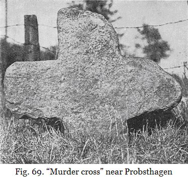
Eastward from the cross near Meerbeck there stands at the same distance (5 km) as from the cross in Schaumburg forest, and southwest of the Schäferhof, a similar old stone cross. It is now well set up on the highway to Stadthagen, in a small plot of meadowland near an agricultural field belonging to the commonalty of the town (Fig. 69). It was probably removed from this field, where it had become inconvenient on the change to agricultural use, to the meadow plot where it would not be a nuisance; so that its original site – probably at the fork of the road near TP 68.1 m – can no longer be fixed exactly. Its present site is about 300 m south of the east line of the Hünenschloss [giants’ castle] (highest point), while the deviation of the other two sites from this line is not detectable on the map. The marker in the Schaumburg forest was at the “Hain”holz. In 1830, Head Forester von Kaas sought out this spot for his grave. A mighty oak, treasured for 500 years, is now the sign of the old sanctuary. In its youth it may still have seen nearby the mark-cross by the decaying holy oak. An earthen rampart, now called “Hudegrenze”, could well have served to define the boundary of the former mark-place. In any case we have in this line such an impressive phenomenon that an explanation by chance is hardly possible. I show illustrations of the two “murder crosses” also. Who can add something about these crosses, so striking even in their present state, to what Kuhfahl has published so thoroughly and impressively in the above-cited work on stone crosses? |
Anyone who is convinced that every major settlement of our religiously-inclined forebears had its local sanctuary, its grove and playground, and its oriented hill sanctuaries, is now asked to take a fresh look at their own district. Above all, the following questions are to be asked: (1) Where will our forebears have had their moot-place? Take into consideration the road plan, church site, graveyard, chapel; high spots; spring or pond. (2) Do the cardinal points give, on the horizon or on lines to the horizon, any indications that orientation markers might have existed there which would then also confirm the position of the moot-place? If there seem to be constant failures, remember the first Edict of Nantes, on account of which we have the prospect of finding only a tiny percentage of the ancient sites. But sometimes quite small indications combine to betray things that were meant to be effaced from memory.
| 48. |
Let us take for example the old settlement of Hameln-an-der-Weser [Hamelin].
There can be no doubt that the church of St. Nicholas by the market, sited at the main crossroads,
stands on the moot-place of the old settlement.
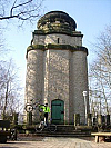 Bismarck
Tower The Bismarck Tower 2½ km to the west, a spot apparently singled out from the earliest times, fixes the equinoctial line of the Hamelin moot-place at sunset. At sunrise we have similarly, as the east point, the western peak of the “Dütberg”, whose name indicates an old “people’s hill”. The north point on the Roter Berg [red hill] is now distinctly marked by the belvedere, which is not placed exactly on this spot for nothing. And the wanderer is standing on the south point if he visits the Ohrberg, which still serves for the people’s recreation, and stepping out of the park enjoys the glorious view. |
But the people of old Hamelin were pious and practical; in order to celebrate their summer festival they wanted to know the times of approach and arrival of the summer solstice; and where the forester’s lodge “Heisenküche” now stands, and up above on the “Schweineberg” (crossing of footpaths at 258 m) they had reliable aids when seen from the moot-place. Is the name Heisenküche perhaps derived from Hexenküche [witches’ kitchen], having been first satanized and then made fit for the drawing-room? That the name Schweineberg [swine hill] had its origin simply in the existence of wild boars, which were once to be found on all wooded hills, or that the place served especially as a pasture for pigs, is less credible than the notion of public tending of sacred boars in the Germanic period, which gave particular reason to bring the site into contempt.
Studies on the orientation question so far are a preliminary exercise, which is admittedly subject to error in many details, both as regards fundamental concepts and attempts at explanation, and also as regards the sites considered; but it has, I believe, established orientation as a fact. The conclusion can be summarized as follows:
1. The hypothesis of a general preference for orientation in old Germania is based on so many striking pieces of evidence that, even allowing for the inevitable initial errors, the explanation that the phenomena arise by chance is not acceptable. To recognize even a single phenomenon as deliberate orientation is to recognize orientation as such and all its premises, which are first and foremost based on astronomical activity.
2. Orientation as an important popular usage consisted in this: the moot-places, camps, settlements etc. provided markpoints on the horizon for the cardinal directions; these markpoints took on the character of religious sites, and were then in turn provided with orientation markers in the same directions.
3. We may suppose the earliest origin of orientation lay in satisfying a religious feeling. To this was added the practical need for time division, especially after the beginning of agriculture: and finally came the use of the existing orientation network as a signalling system in war and peace through smoke, light and sound signals.
4. Orientation phenomena are explained most simply if we assume they began when people first began to take possession of the land, and were still free to settle wherever they liked. But here we must avoid the mistake of supposing that the first settlements, camps, etc. were themselves set out in orientation to one another; rather we should suppose that initially markers were created for these oldest sites, and later settlement was then in many cases related to these.
5. Orientation is universal in Germanic countries, and its most important principles are uniform and constant, so that neither the lapse of time nor possible movements of population have exerted a marked influence. Its decline set in with the age of Charlemagne [239.1].
6. The condition and permanence of the markers varied greatly, according as a marker became important and an assembly place for festivals or the nucleus of a settlement, or not. It could be a simple tree trunk stripped of its branches or a standing stone, with a fire site nearby – up to the ceremonial tower erected as a beacon, or other building.
7. At first there was probably only the fundamental north orientation, the most important for religion. Later, by constructing a perpendicular, there was added the west–east line, which was more valuable in practice, and in the late Germanic period will have had the greater importance and more frequent practical use for the Ostara festival and as the most important calendar line. Again, the west–east lines that we can still find seem more numerous than north lines. – Because the cults for different deities were strongly differentiated we may assume that at nodal points, where two orientation lines crossed, there were two ritual orientation markers placed side by side.
8. The lines to the extreme positions of the sun and moon, which are found here and there, can only have been of local importance, because they are astronomically valid only over a small region. They contrast with the north and east lines, which remain astronomically valid however far they are extended.
9. The ancient people’s astronomical and geometrical surveying across hill and valley was highly developed, which is unthinkable without training. The average value of the surveying errors was apparently kept below ½ degree and the largest errors appear seldom to exceed 1 degree. The hypothesis of an astronomical training school at the Oesterholz estate gains new and significant support from the existence of orientation and the connection of the estate with the orientation network.
10. In view of the religious inclination of the people and the many-sided importance and use of oriented markers, including as stations for worship, we must deduce that the whole country was densely occupied by them, down to the smallest markers in the fields to fulfil the religious needs of individuals and families.
11. Because religion and cultic practices of ancient peoples were so varied, we should nevertheless assume that only a fraction of the cult places were oriented, namely those which had a direct connection with star worship, or in which there was a practical need for orientation.
12. In the small field-sanctuaries we can see the forerunners of the crosses, wayside shrines and small chapels of the succeeding Christian period. In accordance with a custom of the Christian church, these latter were placed during the conversion period exactly on the sites of the former and, provided they have remained in the same place, serve as signposts in orientation research. They are accompanied by numerous other indications, so that research in this direction can be called promising.
To clarify the question of chance, a prize competition was set up, in which contestants were invited to make a collection of equally important and numerous lines according to some arbitrary orientation system. The competition closed on 31 March 1930, without any proof that an arbitrary orientation system could rival the real one. The three entries sent in completely failed to undertake the appointed task, but instead yielded still more examples of deliberate orientation by ancient peoples. See Germanien, volume 2, issue 2.
This result should not be underestimated. It means the failure of all those who, hoping that their efforts would be rewarded with a prize of 1000 marks, intended to prove that by using an arbitrary system of lines it would be possible to present a list of examples with the same archaeological value as my own. If such efforts were successful, then also the list of examples that I provided would not necessarily be the result of deliberate astronomical orientation by ancient people, but could equally well arise automatically from the positional relations of archaeological sites amid all other sites. This, of course, would have shown conclusively that my method of proving the orientation theory, by giving examples, was inadequate – as long as everything was decided by trustworthy arbitration, such as we should expect from the Berlin Society for the History of Science, Medicine and Technology. But this would not dispose of the orientation question itself.
The above method, namely offering a prize, has so far proved the most useful. An attempt to clarify matters by a purely graphical and mathematical method is doomed to failure from the outset, if the decision about the archaeological nature of the sites is not left to unbiased persons, and if the method is not restricted to the same ideas and limits as are contained in my list of examples. Doubling the limit of accuracy is enough to make the comparison useless.
The result of the prize competition should not be overestimated either. Obviously, by spending a boundless amount of time and effort it is possible in the end to collect a greater number of similar phenomena based on an arbitrary system of lines. But the time and effort to be spent cannot be prescribed in a few simple rules. So it is inevitable that here, as in so many cases of alternative archaeology, the final decision is left to the individual who has weighed up the reasons for and against in the light of his own judgement and experience.
I hope that the weight both of the examples given here and of the argument from necessity has led the reader to a clear decision in favour of our important orientation theory.