Journal of Geomancy vol. 4 no. 1, October 1979
{9}
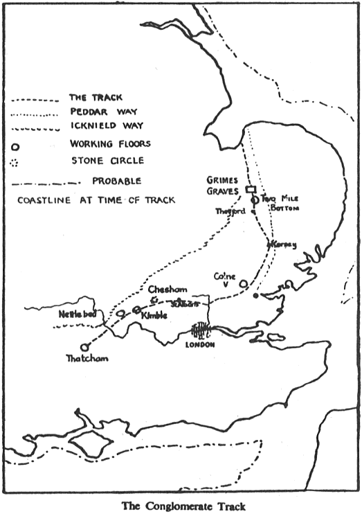
From Heacham on the Norfolk shore of The Wash to Thatcham in Berkshire runs a prehistoric trackway over 200 miles long, older by far than the Icknield Way. At irregular intervals it is marked by standing stones, many of which are to be found in the fabric of churches, demonstrating the extreme antiquity of this track. And each megalith is of conglomerate rock, a distinctive type of stone which kept the traveller safely on the right path. It is the only ancient route which has as its goal the important flint mines at Grimes Graves, and its use was obviously to transport the much-needed flint to settlements in the south and west. Over 100 puddingstones mark the route, each one geomantically placed at a sighting-point, with ancient mounds and moats helping to mark the way. Although not a continuous ley, the track is composed of many short alignments, with each point visible from the next.
The above is a necessarily brief outline of a theory put forward by Dr E.A. Rudge, Principal of the West Ham Municipal College, and read to a meeting of the Essex Field Club on October 29th, 1949. In the spring of that year Dr Rudge began an investigation into the practicalities of ley-hunting in Essex, but the discovery of four puddingstones in an ‘almost’ straight line near Waltham Abbey caused him to forsake Watkins and led him into the wider field of the trackway. He continued to publish his findings in the Essex Naturalist and the East Anglian Magazine until 1955, when the criticisms levelled at him by other researchers seem to have proved too much for him, and he gave up with a book on the subject only half-written for lack of a publisher. The bulk of evidence for the existence of the track rests with the sole use of conglomerate rocks for the mark-points. Its more common name of puddingstone derives from the fact that its constituents resemble a plum-pudding, being a mass of flints or other pebbles held together in a natural ‘cement’, and it is a type of stone that cannot be confused with any other. However, after consideration of his critics’ statements, and long study of Rudge’s own work, I have reached the conclusion that not only does his theory of the track have no basis in fact, but that a number of the trackstones were not even conglomerates. Although I have as yet visited only 10% of the sites named, and these all in Norfolk and Suffolk, the evidence points to the fact that Dr Rudge seriously deluded himself, and unwittingly misled many later researchers.
He claimed, for example, that “most of (the trackstones) are situated far from inhabited places, and the trackway consistently avoids passing through towns or villages. Moreover, it rarely coincides with a modern road, never with a Roman road, and in all these observations lies the most convincing claim to extreme antiquity.” (1).
A study of the sites named demonstrates quite the opposite. The final form of his track gives a total of 136 individual megaliths, and of these 76, or 55.8%, actually lie in villages, towns or cities. Similarly, 69.8% can be seen to lie on or beside roads or paths. In 3 instances the stones are beside a Roman road, and one of these should be taken as a case on its own. Rudge stated that the puddingstone track runs between Icknield Way and Peddar’s Way for some of its length, “and at no point in its entire length crosses or touches either of them.” (2) At the time of writing, the course of the Icknield Way beyond the Norfolk border with Suffolk was completely unknown. Since that time we have learned that, after reaching Thetford, Icknield splits into two. One branch heads east through Larlingford towards New Buckenham, whilst the earlier route continues northwards, eventually reaching the shore of The Wash at almost the same spot as the puddingstone track. West of Swaffham, Icknield crosses the line of Fincham Drove, a Roman road heading east from the Fens. Where the two cross is a well-known boulder called the ‘Cowell Stone’ (so-called not from any geomantic derivation such as ‘cole’ or ‘cowl’, but from the Cow Hill on which it stands), and besides being a point on four parish boundaries, it also marks the meeting-place of three ancient Hundreds. Rudge made much of this particular stone as a marker for his trackway, which he {10} says can be followed by a greenway north from this point through Narborough and Grimston to The Wash. However, upon inspection, this boulder turns out to be not conglomerate, but a sandstone erratic of a type quite common in the area. Also, the ‘greenway’ heading north is none other than Icknield itself. For several miles, the puddingstone track is in fact the Icknield Way! Rudge says: “Neither Icknield or Peddar’s Way can be shown conclusively to lead to Grime’s Graves. … we have found no evidence to show that any prehistoric road other than the puddingstone track had as its sole objective the famous Norfolk site …” (3)
Whilst the Graves were undoubtedly important, they were by no means the only ones in Norfolk, and Icknield passes right by the Buckenham Tofts flint mine also. The stones at Grimston and Gayton too lie on the line of both Icknield and the track, but both are sandstone, not conglomerate. There was in actuality no conceivable reason for a route for the purposes of flint-trading, since that stone was just as plentiful in the south as it was in Norfolk. Rudge believed that the track was laid out by the mesolithic Tardenoisian people, contemporary with the heyday of Grime’s Graves. Radiocarbon dating (uncorrected) shows however that the Graves were worked between 3000 and 2500 BCE, considerably later than Tardenoisian times. The Church Hill mines on the South Downs were in use well over a thousand years earlier, and others even earlier still, so there would seem no purpose for the track.
Ignoring possible purposes for the moment, what other proof or disproof is there for Dr Rudge’s trackway? He emphasized many times the ‘ridgeway’ character of the track, how “the track-builder avoided the chalk as effectively as he did the boulder-clay of East Anglia, carefully plotting his way from gravel-cap to gravel-cap along the upland ridges.” (4) And again “… one of the most striking properties … is its adherence to the gravels and its avoidance of the chalk.” (5) In truth, Rudge chose a very poor route for his track-way. From Beauchamp Roding in Essex to Kersey in Suffolk, the track lies upon the lowest land available, the sands and loams of the east coast Sandlings, which in very few places rise above 200 feet. And far from avoiding the boulder clay, the track cuts straight across the middle of the Suffolk boulder clay belt, which occupies two-thirds of the county.
The moment it leaves Suffolk heading north, the track enters the chalky boulder clay region, and like Icknield actually adheres to the chalk ridge for the last part of its journey, from Swaffham to Hunstanton. If Rudge’s puddingstone trail had had a true ridgeway nature, it would logically have followed Icknield all the way. Alternatively, it could have struck north from Magdalen Laver in Essex towards Bury St Edmunds, following the highest ridges of 3–400 feet all the way, and reached Grime’s Graves by a straighter route.
It should be borne in mind that Rudge maintained “without a single exception every trackstone is of conglomerate rock.” (6) Of the three I have mentioned so far, not one has been conglomerate. But what of some others? Although he had previously been convinced that Grime’s Graves was the ultimate goal of the track, it was not until the summer of 1951 that he ‘discovered’ a stone at the site itself. To quote his own words, “we had consulted the Proceedings of the Prehistoric Society of East Anglia for accounts of the excavations … and had noticed in a sketch plan a feature described as an ‘Erratic Boulder’… It was sufficiently remarkable as the only boulder found in the district to receive special mention by the surveyor, it is a sandstone conglomerate containing flint pebbles … and in our view is undoubtedly one of the track series.” (7)
Turning to his original source, we find that there were in fact TWO boulders mentioned. Apart from conveniently ignoring the ‘unsuitable’ stone, Rudge evidently could not read, and he was no geologist. In the PPS of EA report we find this: “One of these was identified by Prof. P.F. Kendall, F.G.S. of Leeds University, as Lincolnshire Flint, the larger one being Carstone, from the Lower Greensand of Lincolnshire.” (8) Whatever happened to Rudge’s puddingstone? In Thetford (where again, the track coincides with the Icknield for a distance) he found six conglomerates, four on the north side of the old ford, and two on the south. Those on the south I have yet to find, but I have seen those on the north, and only one is conglomerate, the others being Neocomian limestone and sandstone. At Hall Farm in Fornham St Martin, Rudge found another trackstone, this one with an interesting tradition attached. This was called the ‘hiring-stone’, and it is said that around it, wages were once paid and men were hired. I visited this particular stone and found that it is {11} indeed conglomerate (for a change), and the owner of the farm informed me that he still met his workmen there every morning. He also added that he believed the stone to be “some kind of marker on the Roman road that used to go through here.” It could be that he had heard of Rudge’s theory, or perhaps he was thinking of the Roman way that passed a mile to the south along Hollow Road, connecting Icknield to Peddar’s Way. In this and two other instances (Ingham, and West Farm south of Thetford) Rudge stated that ancient greenways ran by the stones and were part of his trackway. However, reference to Faden’s 1797 map of Norfolk and other maps shows that none of these tracks are older than c. 1900. At Thurston, Dr Rudge made what I consider to be his greatest and most obvious error. He made much of a massive lump of rock that stands in the churchyard, close to the church wall, claiming that the village was named after it: ‘Thor’s Stone’. Apart from the etymological blunder, the stone is in truth a flint-covered section of masonry that was once a part of the church fabric. The tower and then the building itself collapsed and was rebuilt in 1860, this section never having been cleared away. Another small rock can be seen in the outside angle of the tower at Chelsworth church, but this is sandstone, not a conglomerate as Rudge claimed.
That set into an earthen bank of an orchard at Drakestone Green certainly is a type of ferruginous conglomerate, and that embedded in the pavement at the north end of Kersey village is a puddingstone. But the small boulder by the ford or watersplash in the latter village is sandstone.
A three-foot high megalith at Whitestreet Green is the last of Rudge’s trackstones in Suffolk before the Essex border is reached, and this is indeed a puddingstone. The vagueness of Rudge’s list of his trackstones led me to visit a few sites (Nayland, Felsham, Hessett, and two ‘Gallows Hill’s near Thetford and Gayton Thorpe) which had never in fact possessed a puddingstone; but at one, Hessett church, I found a sandstone erratic that shows he was wrong in stating that only conglomerates were found on the route.
The Suffolk/Essex border was supposedly crossed at Nayland, where a site called the ‘Court Knoll’ stands on the track. This in fact is a medieval site, where the local manor house once stood. As to the other sites in Norfolk and Suffolk, I have visited three where the stones are no longer extant, and I have seven others to inspect. And what of the other counties that the track passes through: Essex, Hertfordshire, Buckinghamshire and Berkshire? Being his ‘home-base’ as it were, Rudge did more work in Essex than anywhere else. But even here, his conclusions are open to question. He began his investigation with Dr A.E. Salter’s list of Essex boulders, and although it barely scraped the surface of the subject, it provided an adequate starting point (9). Regretfully, Rudge chose to ignore Salter when it suited him, and his work suffered as a result. For instance, he mentions conglomerate blocks at Beauchamp Roding and Fordham. Salter too lists these particular stones, but he says they are sarsens. Salter was an accredited geologist; Rudge was not. Salter lists a number of puddingstones along the line of the Cripsey Brook, which Rudge rejects, saying that the brook is a prolific source of this material and should be discounted. Yet Dr Rudge names 11 other puddingstones less than a mile from the Brook, and claims that these are part of the track! Similarly, in Hertfordshire: Rudge based his work on Salter’s list of Herts. boulders, then ignores it when it fails to fit his theory. Rudge includes in his trackway a puddingstone standing at the Ver ford in St Albans. Salter however, says: “Mr. Hopkinson informs me that it was dredged from the River Ver close by on Jubilee Day and set up on the green as St Michael’s Jubilee Memorial to Queen Victoria.” (10) Rudge mentions a conglomerate outside the museum in the city, that was once in front of the Moot House. Salter lists two, and both are mammillated sarsens. In total, Dr Rudge remarks on 12 puddingstones that mark his trackway, running west to east through the city, and one of these was sarsen. Salter lists eight others in the city that Rudge ignores, stating also that conglomerate blocks are very common in the bed of the Ver. The 13th Report of the Committee on Erratic Blocks for 1885 (B.A.A.S.), which Rudge used, lists four conglomerates around Tolmers and Tylers Causeway in Herts., which Dr Rudge chooses to discount since they are not quite on his projected line (11).
“… In spite of systematic search we have found no similar stones anywhere else except such as can be traced to natural sources such as the beds of rivers and natural outcrops, and those which have been placed in position in living memory” (12). In effect, Rudge is damned by his own words, since with a little research, quite a number of his trackstones can be found to have exactly the same origins. He stressed that he had found no evidence of any side-branches form his main route, {12} indicating its importance (13). In the same work he relates how he was side-tracked by a puddingstone at Semer in Suffolk into following the southern extension of Peddar’s Way, and only realized his error later. Even earlier than this, in his 1949 paper, he speaks of “cross tracks branching off at right angles, for instance at Epping Upland, Magdalen Laver and Whitestreet Green (14). “And later were found traces of a branch heading for Henley-on-Thames.” Contradictions, assumptions, selectivity and misrepresentation abound in Rudge’s work, to his great detriment. He realized in the end that random distribution of puddingstones was the key factor in the proofs of his trackway, and criticisms by A. Morley Davies helped him in this realization. Davies and others conducted a systematic search of Bucks. and adjoining areas, discovering over 260 puddingstones. As Davies said, “This compares with 125 (at that time) on which Dr Rudge relies to trace a track from the Wash to [the Berks.] Thames.” (15)
Finally, Rudge admitted that there were “grave difficulties” to be overcome in selecting certain stones to prove the existence of a single track, and chose to rely instead on the section from Essex to Norfolk for his evidence (16). As I think I have already shown, the evidence available from those counties is highly unreliable, which leaves Rudge with very little to base his case upon.
Even at the best of times, he seems to have been rather uncertain as to which course his track should take, such as in the case of the puddingstone in the old churchyard at Great Livermere in Suffolk, which he conveniently ‘forgot’ when he found the stones at Ingham, Timworth and Farnham to the west. The original map that was published in 1952, with the track sweeping quite smoothly east then north bears little resemblance to the disjointed, branching, line that is really the puddingstone trail. His statements about the short alignments also bear no relation to the truth as evidenced by maps. A great deal more could be said about the shortcomings of Dr Rudge’s work, but lack of space here forbids a deeper investigation. Further fieldwork is required in the more southern counties to confirm my findings from East Anglia, and I hope to accomplish this and publish the results in the very near future.
Older papers in The Essex Naturalist can be viewed online free of charge. For Rudge’s papers on the puddingstone track, see the list of links on this website. – MB, February 2016
(1) E.A. & E.L. Rudge, Essex Naturalist Vol 28 (1950), p 180.
(2) E.A. & E.L. Rudge, Essex Naturalist Vol 29 (1952), p. 27
(3) Ibid.
(4) Ibid., p. 19.
(5) Ibid., p. 27.
(6) Ibid., p. 17.
(7) Ibid., p. 24–5.
(8) Prehistoric Society of East Anglia: Report on the Excavations at Grime’s Graves, Weeting, Norfolk, March–May 1914, p. 34 (H.K. Lewis, London, 1915).
(9) A.E. Salter, Sarsen, Basalt and Other Boulders in Essex, Essex Naturalist Vol 17 (1912), p. 186–199.
(10) A.E. Salter, Sarsens and Other Boulders in Herts. Trans. Herts. Nat. Hist. Society, Vol 14, part 2, (Jan. 1911), p. 136.
(11) Thirteenth Report … of the Committee on Erratic Blocks. British Association for the Advancement of Science Reports, (1885), p. 322–5.
(12) Essex Naturalist, Vol 28, p. 174.
(13) Essex Naturalist, Vol 29, p. 25.
(14) Essex Naturalist, Vol 28, p. 180.
(15) A. Morley Davies, East Anglian Magazine, Vol 11, p. 499–500.
(16) E.A. Rudge, Essex Naturalist, Vol 29 p. 185.