Journal of Geomancy vol. 1 no. 2, January 1977
{39}
Thank you for my copy of the Journal of Geomancy. I found it a most stimulating publication, and although I thought the article by Robert Forrest was very informative I think there are as many loop-holes in his hypothesis as he seems to find in “Mathematical probabilities of ley-lines”:– briefly,
1. “intervisibility, for example, is not considered” WHY NOT?
2. “without regard to other factors such as folklore and fieldwork” – this is a major fault, surely fieldwork is so important that it cannot be totally ignored – O.S. maps are notorious for being inaccurate (by small errors that are magnified by distance).
3. “It is very easy to pick out intricate patterns of sites” – of course it is if you are going to use every town, river, crossroad, house, farm, railway station, track. One point is that “random” blobs do not simulate ley-points. If an area has few sites of great antiquity (say only 14) yet you find there is a 6-point line – what is the random chance of splashing 14 dots on a page and linking 6! The point I am trying to make is that the more blobs on the map (ie. Forrest’s 468 random blobs) the more chance of 3, 4, 5, 6 point lines – a hypothesis that Mr. Forrest makes regarding Warminster.
************************************************************************************************************************
Editor’s Note:
This mathematical approach which has recently been applied to the study of
aligned sites is noticeably directed at the works of Alfred Watkins, who studied
only alignments. As can be seen from the researches of Hudson, Heinsch, Gerlach,
Behrend and others, lines are just part of the pattern, significant azimuths and
distances playing their part. Mathematics are no more infallible than any other
human activity. Randomness theory, when applied to objects which were
deliberately sited, such as churches or stone circles, is a false application,
as parishes etc. cannot be taken as random. They were deliberately laid out by
surveyors in antiquity, not a random action. No doubt, just as the pundits who
claim phone boxes are in line (and so they may be, if placed at equal distances
alongside a straight road) is proof that leys do not exist, so the layout of
Stonehenge could be proved to be random, if the ‘correct’
mathematical model was set up!
************************************************************************************************************************
Dear Sir, I would like to comment on Ian Worden’s article “Ley System Measurement” (J. Geomancy 1, 15), in which my research is mentioned. I have spent many hours myself trying to trace connexions between ancient units of measure, but I now believe that with our present knowledge it is impossible to reach any firm conclusions. The Egyptian cubit, the Roman foot, etc. varied according to place and date, so that different authorities now give slightly different values, and the “true” values (if this really means anything) are no longer known. Difficulties are increased when such inaccurate books as Michell’s “View Over Atlantis” and “City of Revelation” are used as a basis for research.
The figure of 11·5 inches which Michell calls “virtually” a Roman foot (View over Atlantis, part 2, Chapter 2), and which Worden therefore adopts, is too low. In fact, the X unit is very close to 1000 Roman feet – possibly by chance. The Roman Pace was 5 Roman feet, and {40} thus nowhere near 2·43 British feet (City of Revelation, Ch. 10). The “Cow Yard” may have been meant as a joke.
It is obvious from Chapter 3 of City of Revelation that the cubit of 1·728 feet was invented by Michell to fit his theories. The Y unit equals 884 cubits of 525 mm. Even if Y is allowed to be 880 cubits, the figure of 880 yards in half a mile can date only from the institution of the present British Foot in 1305, the mile being originally 4800 Saxon Feet of 13·2 inches.
The X and Y units are known to.the nearest tenth of a metre, much more accurately than a quarter of a percent. Unit X can be derived by dividing the Earth’s equatorial radius into 6 × 60 · 60 parts; this gives 295·285 metres, without any need to invoke “ideal” dimensions to explain away the error. The Y:X ratio is 11:7, not 8:5. All this was pointed out in the Institute of Geomantic Research Occasional Paper No. 1. Nor is 8:5 equal to the golden mean (View Over Atlantis, Part 2 Chapter 2). When expressing X and Y in terms of the hypothetical Megalithic Mile, Worden has multiplied by 2·72 instead of dividing.
Personally I can’t see any point in specifying the X unit as 800 Remen, considering that (a) this figure has been rounded off from 796 or 797, (b) the Remen is not now, and perhaps never was, a precisely defined unit, and (c) observed distances cannot be expressed in Remen without first converting from some system in current use, so that you might as well use this system for X and Y to start with. It seems natural to express X and Y in metres, because distances between sites are measured in metres by means of the National Grid, and because the metric system is understood by researchers in all countries. Why this weird belief, in certain quarters, that the use of the metre in geomancy is somehow morally wrong? One may well object to the attempt by commercial interests to make the metric system compulsory, but that is no reason why it should not be used where convenient,
************************************************************************************************************************
Dear Mr. Pennick, Thanks for your information on Stanton Drew and Ley lines. May I venture to report a possible ley going possibly to Stanton Drew – this is unproveable as yet. Here it is:
Maps 166 Luton & Hertford; 167 Chelmsford and Harlow O.S. 2 km:1 cm.
Fieldwork: Limited to Bramfield area to Thundridge.
1) Locating unnamed wood on map by Bramfield to B1000 connecting ‘B’ road; Name locally: HOLLY GROVE WOOD. Holly = Holy seems admissible.
2) Large wood by Hertford to Bramfield road. PRIESTWOOD is local name.
3) Bengeo Lammas Land. LAMMAS is important Celtic and Witchcraft festival. Spot in question gives view over shallow valley to Priestwood and is a meeting of 4 bridleways/footpaths.
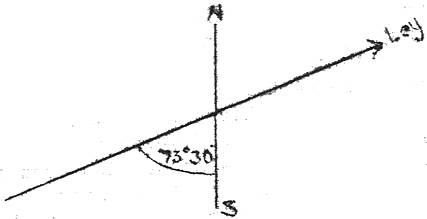
4) THUNDRIDGE. A tower is marked – in fact this is the tower of the dismantled church original to Thundridge, where occupation seems to be shifted more onto the A10 road, where the used church is 19th century. The old church is known locally as Thundridge Temple – probably a link with Knights Templars of Bengeo Temple (Farm) and Chelsing Farm (long since both original sites being razed to the ground, virtually untraceable on site). Temple tie-up may be irrelevant, but demonstrated the ‘TOWER’ is not without antiquity. Cannot reach top for view, as tower is derelict. Ground rises, for it is in a dip to ‘Sawtrees’ farm.
Hence a base of 4, establishing the siting of any line at 73° 30′ ± 30′ relative to N–S grid, thus: (P.T.O.)
{41}
hence 3 more points would be needed to prove the line beyond most possible doubt. These are admissible:
1/ Possible at Friars Wood as mentioned.
2/ Church at Tewisbury.
3/ Pond in Blackfan Valley.
4/ Viewpoint marked on map.
5/ Possible alignment with a main road in Hemel Hempstead, or if angle is 73°, 2 unchecked churches in Hemel Hempstead.
6/ Definite alignment in 167 with straight track by ‘Moor Place’, Much Hadham.
7/ Definite alignment with a church site in Bishop’s Stortford, unchecked as yet.
8/ Line fades out for a long way; only vigorous examination of names of woods on the line can determine its existence – this seems a key piece of work. .
9/ If point(s) 8 can be established, then an unchecked church site near Gosfield Hall, Essex, can also be added at approximately 24 miles from point 7. The existence of this line presupposes, I think, a landscape even more treeless than at present, hence the age of the line may be very great.
Preliminary Conclusion
Existence of ley extremely likely. (a) research in Bishop’s Stortford at 7/ (b) then work with local old folk on the alignment out to Gosfield, and (c) just one .significant name between Welwyn Garden City and Hemel Hempstead (d) with the church or road alignment checked in Hemel Hempstead. Given these 4 conditions, the line becomes a certainty. I hope the I.G.R. will be able to finish the study, if indeed you think it is a possibility which I suggest, if I may, that it is.
Here, if anyone has any doubts about the existence of leys is a case quite beyond chance – I have today (28-10-76) traced a textbook case from being somewhere with a very eerie ‘feel’ to it. It was about an hour and a half before sunset, so this probably helped, but then I looked at the track near it and … the penny dropped!
Ley Sheet 166 Luton and Hertford
1) Stapleford Church
2) Straight track by Newgate Wood near Hunsdon.
3) (Sheet 167) At edge – this continues, breaks, continues a few more yards and can be picked up again in Harlow, Mark Hill North.
4) Earthwork between Gilston and Eastwick.
5) Magdalen Laver in Essex.
6) Foster Street, Essex.
7) Nether Hall Church, Moreton.
8) Cross Lees Farm near Fyfield.
9) Church near Margaretting Hall near Ingatestone, Essex..
10) come back a bit to notice towards Mill Green ‘Parson’s Spring’. Ley alignment also goes through ‘Monk’s’ and ‘Barrow’s’ Farms.
9 or 10 points. {42}
Further findings on Sheet 166. I discovered an error on sheet 166 due to a footpath taking a kink to allow a moat, being placed across it. The findings on 166 becomes:
1) A low hill marks edge of the map where the ley comes through. It is picked up again as a parallel (short) length of road with Watton at Stone church near Stevenage.
2) With error granted, ley passes by side of a wood and through a pond at Temple Dinsley. I suggest the temple name is not just a Templars’ association, but older.
3) Crossroads adjacent to the church at Great Offley near Hitchin.
4) Fairy Hole near Barton in the Clay, Beds., allowing for error, would still cause it to pass through a hilltop ‘fort’ called Ravensburgh Castle.
5) An alignment with a road by the Grange, near Harlington.
6) The ley passes adjacent to a farm known as Priestley Farm and through a ‘Priestley’ Plantation. It would be interesting to establish if the plantation was utterly new rather than a replacement of an older wood with the name ‘Priestley’.
Conclusion. Not quite enough to stand alone, but given points on 167, these are a strong pointer to a longer ley than only on 167.
Further Notes. Sheets 152 and 153 yield 1 and 6 possible points respectively. Groundwork would be essential here as the error becomes so high as to be unacceptable. Error on the 166–167 trace at Hunsdon join of the sheets I would estimate at ±30′. If the line could be established as running across more than two sheets – this margin would be cut if not almost eliminated.