{822}
Straight lines on an ancient landscape
Archaeologists have long ridiculed ley lines—the idea that prehistoric sites were deliberately aligned.
But a little exploration along the alignments could soon show whether leys really exist, and if so, why
In 1921 Alfred Watkins made an apparent discovery that was startingly simple and yet revolutionary. While studying a map of his local Herefordshire countryside, he noticed that certain ancient sites marked on the sheet fell into straight lines representing alignments of prehistoric monuments and other features running for kilometres across the landscape.

A. Watkins
Watkins called his alignments “leys”. He agreed this name might be
in error, but by convoluted etymological detective work he felt he had
established a link between the Saxon word for a cleared strip of land and his
lines. These leys were the remnants of Neolithic traders’ routes, Watkins
surmised, which had ranged across the countryside and were marked with standing
stones and mounds of earth or cairns. These marked lines ran from hilltop to
hilltop like “a fairy chain”. The hilltops were marked with
earthworks or were traditional beacon sites—summits well placed for
line-of-sight communication. Because we associate beacon fires with the rapid
communication system of the Elizabethans, Watkins maintained, we had overlooked
their equal usefulness as surveying instruments. These surveyors’ beacons
were later enshrined in traditions such as the Beltane Fires, according to
Watkins. He called such hilltops “initial points” and found that
holy wells sometimes fulfilled this function too. These old straight tracks were
further marked during the Bronze Age, Watkins suggested,
but the knowledge and usage of them gradually decayed.
In his researches Watkins found that later features—such as pre-Reformation churches and crosses—also, rather curiously, fell on these supposed prehistoric alignments in addition to subsidiary “confirmation points” like ancient crossroads, old fords and certain types of pond.
Watkins died in 1935 and it was not until the 1960s that interest in leys again faredmisprint for flared. During this period, wild and woolly concepts of “national grids” of leys were published and thick black pencil lines defaced countless maps—naive enthusiasm that is still held up for ridicule by ley sceptics. But this euphoric rediscovery of the ley theory gave way to quieter and more sober research. The renaissance of ley research coincided with the disintegration of establishment archaeology’s “woad and skins” attitude to British prehistory in the face of new findings within archaeology itself and unexpected material from other sources, such as Profesor Alexander Thom’s studies of stone circles which gave new cause for inquiry into astronomical and metrological knowledge in prehistoric Britain.
But what are the criticisms of the ley concept? When Watkins put
forward his observations regarding remnants of prehistoric alignments in Britain
he ran head-on into official archaeological thinking which still believed in the
Piltdown Man. The orthodox view was that the megalith builders were just savages
quite incapable of surveying or having any finer thoughts than grubbing for food
and feuding with other tribes. The whole idea of leys was an unprecedented
absurdity—“damned nonsense” as one archaeologist put it.

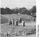
Avebury
Modern archaeology shows that prehistoric societies were complex, though even
without this it should have been obvious that only an essentially stable and
intelligent society would have constructed a structure such as the Neolithic
henge at Avebury and its complex could not have been constructed over such a
span of time;
involving as it did the excavation of a quarter of a million
tonnes of chalk and the transportation and erection of hundreds of stones
weighing up to about 50 tonnes each. And the prominent prehistorian Professor
R. J. C. Atkinson has clearly demonstrated that the laying out of an
accurate, straight landscape line would have been well within the means of the
megalithic builders.
Moreover, since Watkins’s death we have found that inexplicable straight
lines have been left by ancient peoples in other parts of the world.

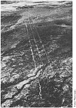
Lines in Bolivia
In 1939, Dr Paul Kosok
{823}
of Long Island University discovered the enigmatic straight tracks on the pampa
near Nazca, Peru, and in 1978 the zoologist Tony Morrison reported on the old
straight tracks to be found in the remote altiplano region of western
Bolivia. Both the Peruvian and Bolivian features are dead straight, going over
topographical obstacles without deviation. But it is the Bolivian lines which
most accurately answer Watkins’s idea of leys. They are up to 30 km
in length and are marked by Indian cairn shrines and sometimes by Spanish
churches (presumably placed on former Indian sites). Some range from hilltop to
hilltop in the manner of Watkins’s “fairy chain” image.
The lines are understood locally as tracks linking holy sites. No one knows who
constructed them.
The presence of these South American lines naturally does not prove the existence of British leys, but it did mean that Watkins’s theory was no longer an isolated, irrational concept.

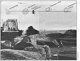
1. Old Sarum ley
An actual criticism of the ley theory, as opposed to mental attitude, has been
that lines on the plane surface of a map cannot accurately represent alignments
on the curved surface of the Earth. This argument is meaningful only for lines
longer than, say, 40 km as the inherent discrepancy is so slight on shorter
distances that the error on the ground is far less than the sizes of marker
sites involved. Any sceptic can prove this by drawing the famous ley running
south from Stonehenge through Old Sarum, Salisbury Cathedral, Clearbury Ring and
Frankenbury Camp (Figure 1). He can then stand on Old Sarum, look south and
see Salisbury Cathedral and Clearbury Ring aligning with it exactly as on the
map.
A more significant objection has been the charge that leys involve marker sites
that vary tremendously in age. A line containing a stone circle and a
pre-Reformation church, for example, has sites separated by perhaps three
millenium—so how could the ley ever have been set out deliberately? Ley
hunters today answer as Watkins himself did, by suggesting the evolution of

2. One of the
Devil’s Arrows
sacred sites. Excavations of churches often reveal earlier, pagan artefacts and
structures on the same site, for example at St Swithins in Lincoln or Wells
Cathedral. Wells, in particular, experienced successive occupation probably from
as far back as the Neolithic period. Furthermore, the Papal instruction to
missionaries visiting Britain was that pagan shrines should be converted to
Christian use rather than destroyed. This process of Christianisation is
well-established, and in France there are extant examples of dolmens and menhirs
being Christianised by a cross or being incorporated into church foundations.
Ley hunters also argue that plenty of leys are marked by
archaeologically-homogenous sites. An example is the 17½ km ley that
runs to the Nunwick and Thornborough henges from the Devil’s Arrows group
of standing stones near Boroughbridge in Yorkshire (Figure 2).
This latter line is also statistically significant; the points on the line are most unlikely to be there purely by chance. And it is with the statistical evaluation of leys that there is most controversy and where much work still needs doing. Watkins thought he had statistically proven the existence of leys but his practical methods were inadequate. On the other hand, some archaeologists dismiss all leys as merely chance alignments without proper statistical investigation. The problem is not simple.
A Cambridge mathematician, Michael Behrend, derived an ingenious formula which shows that sites will align by change much more than one would expect. It is clear that a great deal of ley hunting done over the past 50 years has been hunting chance alignments. The old claim many enthusiasts made that Britain is criss-crossed with leys is almost certainly false. There are, however, alignments which do come out statistically significant, of which two {824} examples are the Craigearn and Saintbury lines.

The Craigearn line was discovered by John Michell among the standing stones and stone circles marked on the one-inch Ordnance Survey map (sheet 40) of the Aberdeen area (Figure 3). Michell, one of the best known authors on this topic, found on this OS sheet, 34 triads, 5 tetrads and 2 triad/tetrad queries. On the sheet, 38 standing stones and 25 stone circles are marked, a total of 63 sites in a map area 47.3 × 71.0 cm (part of the map sheet represents the sea). The map symbol for a stone circle is about 0.75 mm in diameter, the symbol for a standing stone is a dot possibly only 0.1 mm in diameter. This last symbol, however, is much narrower than the pencil lines inserted by Michell to pick out the alignments, and about 0.25 mm is probably nearer the mark for the lower limit of alignment tolerance. Behrend’s formula (see Box) yields the following expectations:
| Standing stones | Stone circles | |
|---|---|---|
| 2c=0.025 cm | 2c=0.075 cm | |
| N(63,3) | 55 | 166 |
| N(63,4) | 0.8 | 7.2 |
where N is the expected number of alignments and c is the radius of the sites on the map. At first sight there is little to suggest that Michell has found anything other than chance connections. But one line stands out from the rest—a tetrad only 5½ cm long (about 3½ km on the ground). Statistically only 0.05 per cent of chance tetrads should come out at this length or less, so that the expected number of alignments like Craigearn lies between 0.00041 for standing stones and 0.0037 for stone circles. This is certainly significant at the 1 per cent level, though we must bear in mind that these expectations are calculated on the basis of a purely random distribution of sites, which may not be quite true in practice.
There is another reason for thinking that the Craigearn line is special. This is because when the tetrads that Michell found on the one-inch map are investigated on a 6-inch sheet, they become distressingly “crooked”. The Craigearn line, however, does not. It stays a very tight alignment at the 6-inch scale (sheet NJ71SW). In addition, as a ley, the markers could all be of the same age.

4. Saintbury ley
A second example of a statistically significant ley is the Saintbury line, in
the Cotswolds (Figure 4). This was discovered on 1:25 000
OS sheets SP13 and SP04/14 and published in
The Ley Hunter’s Companion (Thames & Hudson, 1979). This ley consists
of five sites and is a “mixed marker” alignment—in other words
the structures are of different dates. It can be considered in the context of a
10 km square, eastings 10 to 20, northings 34 to 44.
Let us consider this line at its worst and discount the farm, which can be counted only as “corroborative” evidence of alignment, and even then only if prehistoric remains are to be found there. The line is thus only arguably a pentad.
Over the 10-km square, a site count reveals 18 churches, 1 cross and 7 tumuli, mounds and earthworks. At worst all 18 churches will be pre-Reformation, so the total site count is n=26. The largest site on the alignment has a diameter about 1.5 mm and the square edge has a=b=40 cm. Using Behrend’s formula again (see Box), the expected number of pentads in this context is 0.042. However, the alignment, as a pentad, is noticeably short—{825}only 9.5 cm from cross to mound. Only 0.40 per cent of pentads should turn out to be of this length or less in this context, so that the expected number of pentads like Saintbury is only about 0.0040 × 0.042 = 0.00017—which is certainly significant at the 1 per cent level.
So, even at its worst this alignment is significant. If half the churches are rejected as post-Reformation, the significance of the line becomes greater. If prehistoric remains were to be found at the farm Seven Wells, that would effectively clinch it. “Spade archaeologists” are presented with an interesting challenge here.
Once again the only statistical proviso is that Behrend’s formula assumes a perfectly random distribution of sites, and this is never quite the case in practice.
Despite the statistical success of some known alignments, there is still one statistical objection to be dealt with. It is that by studying the OS maps of Britain for long enough, one will inevitably discover some surprising, but nevertheless still chance, alignments—just as if one plays patience for long enough one will inevitably win. Looking at significant lines discovered on the 1:50 000 map sheets, there are 204 of these sheets in all, and thus two chance alignments, apparently significant at the 1 per cent level, can be expected. However, half-a-dozen such lines would be more than the “patience” argument could comfortably dismiss, and this is about the number of good alignments that are known at present. But not all of these have been discovered at the 1:50 000 scale, and there has not been a systematic ley hunt over all 204 sheets.
So the statistical wheel is still in spin. If modest funding were made available the whole matter could probably be settled in a year or two. (Perhaps for the cost of a few “rescue” digs, in fact, which by their random nature all too often tend to be repetitive or fragmentary in their findings and which further our understanding of the past less than would the establishment of evidence confirming prehistoric alignment practices.)
Ley hunters today tend to think of leys purely as alignments and are to some
extent dubious about Watkins’s idea of old straight tracks—though
the South American paths do present a question mark here. There are no
nationwide ley systems, though possible local arrangements are beginning to be

Uffington ley
discerned—particularly alignments onto “holy hills”, as in
Bolivia and as noted by the German researcher Dr Josef Heinsch during his
researches before the Second World War. The ancient chalk-figured hills of
Wilmington, Cerne Abbas and Uffington have alignments through their summit
earthworks from possibly Christianised shrine sites near their bases. This is a
pattern that recurs at Winchester and Hereford too, and perhaps at other
locations not yet studied. The archaelogical
re-{826}searcher
John Barnatt has recently re-examined alignments, first noted last
century, of stone circles onto key peaks on Bodmin Moor in or a wall , and has
come up with favourable results. How to fit specific hilltops into a statistical
model is a problem, but the predictability of the pattern would make it a useful
tool in evaluating leys.
The most convincing leys are short—usually only a few kilometres in length and probably never more than 30 km long. Leys are not found in all parts of Britain any more than are the remains of other prehistoric features.
On the popular front, however, notions of beams of magnetic energy travelling along leys and othoteniesmisprint for orthotenies—supposed alignment of UFO sightings—persist. Most of the “energy” ideas are based on dowsing results, but until these can be cross-referenced with physical monitoring they must remain on the wilder shores of the subject. The work of the Dragon Project though, is beginning to show that there may be some basis for thinking that unusual behaviour of certain known energies could be taking place at certain sites (New Scientist, 21 October, p 166), and it is possible that our ancient ancestors could detect this “Earth energy”. There is virtually no evidence to associate UFOs (whatever they are) with leys, though there is now a basis of evidence to suggest that stone circles at least, may be associated with geological locations that have a high incidence of geophysically-produced luminous atmospheric phenomena.
Modern ley hunting therefore ranges from colourful popularity at one end of its spectrum to unglamorous, somewhat plodding amateur research at the other. The final determination of the ley theory’s status is obviously desirable; if it is a mare’s nest in Britain, unlike in South America, then it ought to be despatched as quickly as possible. But if it continues to gain in stature, as is the case at the moment, then the necessary resources ought to be put into it by those who hold the purse-strings of archaeology. Apart from the further statistical investigation that is required, there are alignments, like the Saintbury ley, which predict the presence of obscured prehistoric sites and which need testing by excavation.
The whole question of ancient alignment practices remains an important enigma: we do not understand the British cursus-type features (earthern avenues) or stone rows, much less the Andean lines. There are no other data concerning the ancient societies in any of these cases that predict the occurrence of the linear features. Linear preoccupation in the past remains a closed book to modern understanding. The Andean lines, like the British leys, are only rarely associated with astronomical orientations, so archaeoastronomy can be only a part of the linear mystery, not vice versa. The only hint about the use of the lines comes from Bolivian Indian folklore which states that they are “spirit paths”. This echoes ideas associated with Irish faery paths and the old Chinese geomantic system of Fengu Shui.
It may be modern unwillingness to accept that there were activities in ancient societies which we do not understand that accounts for the embarrassing silence of archaeology on the Andean lines and its stubborn resistance to a proper treatment of the ley theory in Britain.