{1}
Among the many remarkable characteristics of Mind perhaps the most inexplicable of its mysteries is that quality we may call forethought, or the power to create by the shaping of present activities a set of circumstances while as yet there are none of them. This phenomenon carries one far beyond mere instinct, indeed has little in common with instinct, for while the latter is conformable and predictable, the former by its tremendous range, has a power and a scope which can never be estimated, being bounded only by the range of Man’s Mind itself.
Examples of the effects of forethought, already in what can be described as a state of high achievement, have in large numbers been found among the remains of prehistoric man; contemporary, indeed, with the earliest of the monuments which have come down to us from the pristine days of Man’s earliest sojourn on earth.
These monuments, among other interesting characteristics, exhibit that for which I have coined the word “Eustasia” or “Right-sightingProbably a slip for “siting”; cf. “Right-sitedness” below.,” carried out beforehand in deciding their foundations, according to a certain doctrine consistently applied and carried into effect throughout the world with the most amazing skill and regularity.
Now it can hardly have escaped even the dullest of observers that many of the Ancient Monuments are to say the least, superbly placed: notable examples being the hill-top Camps, and Long Barrows, situated where the widest views of the land are to be commanded, often indeed upon sites which upon superficial examination would appear to afford little promise of pre-eminence. If this were all, it would at least show that men had had other thoughts beside those merely connected with an instinctive, or animal existence. But some have noted, for instance Hadrian Allcroft, definite indications of the application of measurement and of the existence of (in the view of most orthodox archaeologists) fortuitous alignment, and so long as this curiosity was regarded as due to chance the phenomenon was unworthy of scientific attention and the point has been ignored.
But by far the most remarkable of the 20th Century investigators was that great Photographer and Archaeologist Alfred Watkins, whose Book “The Old Straight Track” is full of examples of the beautiful ingenuity of prehistoric man, and of the serious thought which he gave to Life. The theme of the book is an attempt to explain the very great number of proved alignments of ancient sites with one another and with topographical features of the landscape; and whether or not its conclusions are accepted the book as a whole will well repay study and will in any case “open the eyes of the open-minded” or heterodox student.
It was, indeed, due to such study that the present writer’s discoveries were made early in 1938. These discoveries have carried the matter a stage further by revealing an underlying fact, namely, that beyond the proved alignments which are in number outside the range of calculable chances is the fact that these results are on account of the forethought of prehistoric man. The proof of this, up to the present, has been experimental; and within experimental limits it has been proved that the Monuments were not erected “just anywhere convenient” as would be done by the ignoramuses of to-day, but that on the contrary not only was the site properly dimensioned to accord with its place in the Cult, but was laid down in a certain geometric (or possibly celestio-metric) relationship to other sites, whether or not such sites were already occupied. That the continuity of the understanding and practice of this doctrine of “Right-sitedness” {2} extends from the date of the earliest monuments until well into the Middle Ages has been experimentally demonstrated by the writer.
The original discovery was made on the moors in the neighbourhood of Beaulieu, Hampshire; where, upon the broad breezy heathland, wide open to the wind and rain, or browsing under the summer sun, amid the droning of the heather-hunting bees, were laid to rest the poor remains of mighty men of old. It was of this district that Heywood Sumner wrote, concerning the New Forest area:– “The earliest evidence of man to be found is that of the very numerous round barrows of the Bronze Age on Beaulieu Heath which extend to the Solent on both sides of the River. These burials belong to a comparatively rich civilization which must have drawn its wealth from outside the area of the Forest itself. It can only have come from the fertile valleys of the ‘Spithead and Solent’ rivers which lay between the Heath and the Isle of Wight, and upon the Island chalk itself before the general sinking of the land had cut it off from the mainland.” I may add, furthermore, that these happy people have left no remains of defensive camps, an indication that they lived in peace and had therefore time and inclination for some sort of philosophical activity to take place among them. What they meant by these mounds we shall later see.
It was while brooding over the maps of this Area (Hants 6″ SheetsScale 1 : 10,560 LXXX NE; SE) that I noticed an equilateral triangle whose apices were formed, near the site of Boldre Church, by a cross-roads and by two Tumuli used by the Ordnance Survey as Trigonometrical Stations and whose heights are marked 140′ and 120′, by which figures they are sufficiently identified.
I measured the distance between the two Tumuli and checked it upon the 25″ SheetsScale 1 : 2,500 (the most accurate scale published by the excellent Ordnance Survey people), making it out to be 5700 feet. It must here be remarked that this distance is not necessarily identical with that which would be obtained by a flat tape laid along the ground surface. I then noticed that two other Tumuli in conjunction with .140 were distant from the latter exactly half the perpendicular of my equilateral triangle, and therefore two such triangles could be drawn whose perpendiculars bisected one another at .140 Tumulus. When they were drawn other relationships were speedily found when these measurements and the usual angles, i.e. 30°, 60°, 90°, were applied.
A coincidence of some significance having been established the above distance was further investigated and was found to be repeated in other instances, both in the same area and in other districts; while the search has since been widely extended to many hundreds of sites of the types hereinafter described, in all cases with a positive result, not only as to measurements but as to the angles of the equilateral triangle. Thus the fact is shown that all these sites have a definite place in a world-wide system.
Many of the results tabulated have been communicated through the medium of the Bi-Annual Portfolio of the “Straight Track Club” founded to carry on the late Mr. Alfred Watkins’ work and many others are still in my notes. They were, however, summarized in a postscript which I was permitted to add to the published lecture delivered by the late {3} Major F.C. Tyler, O.B.E. before the London Antiquarian Society and issued in book form by the Straight Track Club. Before dealing further with these crystallised results, however, attention must be directed to the next important discovery, namely, the recovery of the ancient standard of measure.
It was immediately realised that the equidistances and other associated measures must have involved the recognition and use of a Unit Measure, and an attempt was made to fit the 5700 feet into an ancient system. The nearest was the Greek Cubit of 1.52064 feet, for 3750 of these are equal to 5702.4 feet, and as all the measurements made would bear the addition of 2.4 feet without upsetting the system found by Map observation a bold assumption was made and the announcement was published to the limited public available to me, in a paper entitled “The Division of the Earth”.
The issue of this Paper brought a letter from the aforesaid Major F.C. Tyler, then totally unknown to me, an extract from which reads as follows:– Dated 26.10.38. London.
“Dear Mr. Lawton,
I have been intensely interested to read your paper entitled “The Division of the Earth”… The most astonishing thing in your paper is the fact that your distance of 5700 feet (I actually gave the full figure of 5702.4 ft. – Author) is exactly identical with my unit measurement between sites … at least, if you take my actual corresponding figure of 570.24 it is …”
Here indeed was a most remarkable coincidence. Tyler had, by constructing figures upon the Stones of Stanton Drew Circle, obtained a measure equal to one tenth of mine, though without relating it to any ancient standard. My unit of distance was therefore the nicely rounded-off figure of 6 × 54 cubits.
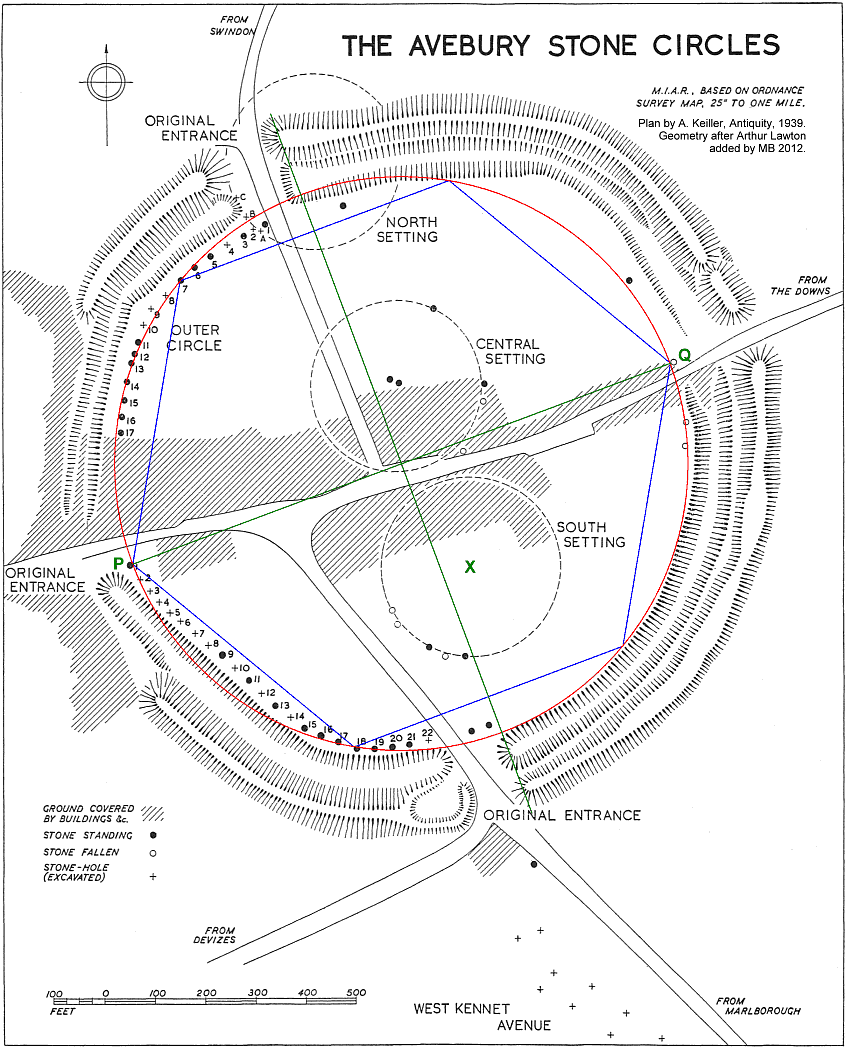
Nor was this all. In 1939 G.M. Hayton announced or rather drew attention to the existence in olden days of the Reed of 9.504 feet; and I at once seized upon this unit for it was contained exactly 600 times in my distance. In this latter form a great deal of use has been made of the measurement; an example, characteristic, being found at what has been described as the best and oldest relic of the Archaic Civilization in England, namely, the great Circle at Avebury.
The official Plan of Avebury shows quite well, considering the age, history and state of preservation of the monument, how the plan outlined will agree with the Site. For instance, the distance between the two diametrically opposite stones I have chosen at random and marked P, Q, is seen to be 1140 feet as nearly as can be scaled. This, i.e. 1140.48′ is equal to 120 Reeds, i.e. 2 × 60 Reeds. Upon this line P.Q a hexagon made up of its six equilateral triangles of 2 × 60 Reeds a side will be seen to fit in quite remarkably; for where each apex touches the various parts it does so at a significant spot as follows:–
| (1) | Western Stone No. 1. | |
| (2) | Stone No. 18. | |
| {4} | (3) | Edge of Inner Bank. |
| (4) | Fallen Stone. | |
| (5) | Edge of Inner Bank again. | |
| (6) | N.W. Stone No. 7. |
Moreover from the centre a circle of the same radius closely follows the edge of the ditch of the South Eastern quarter and the line of sixteen stones of the North Western portion and closes two of the original entrances. The angles of the hexagon are most exactly located upon the stones mentioned, which in view of the irregularity of others is quite remarkable, more especially since a sub-division of each of the 120 Reed triangles into its four component triangles of half the side does not produce a single exact contact with any part of the remains so far discovered – that is to say at a point of intersection: it might be claimed that the supposed South Setting Circle marked “X” fits exactly into the sides of a 30° angle south of the equator which itself forms one of the sides, but for the fact that this setting is in doubt. On the other hand of course a good deal of destruction of the original work has gone on. It almost appears, however, as if the monument were constructed upon the line P Q as diameter, for there are stones at 30° and 60° to this line, while a line joining the western extremities of the eastern half of the ditch is at right angles to P Q and passes exactly through the centre. The angles of 30° and 60° occur in both the northern and southern halves of the circle; and it is not a little curious to notice, in view of these facts, that the modern roads within the circle, connecting the three original entrances and the Downs entrance, closely follow the plan of this cross upon P Q.
So much for Avebury, and having illustrated my theories as exemplified in the Measures of the Archaic Civilization I will now proceed to touch upon a more modern but no less surprising example.
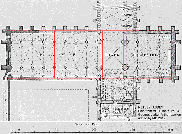
The Abbey Church of St. Mary at Netley, on Southampton Water, a ruin of wondrous beauty, has, according to the Plans published by H.M. Office of Works, dimensions which are consistent with the use of the cubit of 1.52064 feet. This building – originally dedicated by the Cistercian founder monks from Beaulieu on July 25th, 1239, and by Henry III to St. Mary of Edwardstowe in 1251, is divided into Nave, Quire and Presbytery, three sections. The north and south transepts formed a continuation crosswise of the Quire. The ascent to the Presbytery from the latter was by a step which still remains; and from this point to the eastern wall is 42 cubits, which is also the overall width: then we have 18 cubits down the Quire, while the Nave divides into two halves of 42 cubits each. Setting out the sections, we have:–
(7 × 6) + (7 × 6) + (3 × 6) + (7 × 6) =144.
a Biblical number of celestial completion which could not have been realised in a building of these measurements in British Feet and Inches, but only in the Greek Cubit. It may also be worth noting that 42 is a number closely connected with Ancient Egypt’s religious teachings. {5}
I have investigated a number of 11th, 12th and 13th Century buildings of like nature, among them being Beaulieu Abbey, Old Sarum Cathedral, William II’s of Sicily, Cathedral Monreale near Palermo, and others, in all cases finding a correspondence with my thesis. It would be tedious to describe all these in this brief survey of my researches, but before passing on to more theoretical considerations I will describe the results obtained at Glastonbury. I have no actual plans of these remains and for the test of the measurements have relied upon those measurements given by Bligh Bond in his book on the Abbey. However that author, an expert and a worker on the spot, gives as his considered opinion the conviction that the unit of measurement was our English system of feet – on what grounds is not at all clear to me. This might have been disconcerting had I not had implicit faith, born of experience, in my previous results. In general, of course, exact measurements over the foundations of old buried sites must be very difficult indeed; and, although this cuts both ways, a genuine inconsistency would soon be shown up. Here, therefore, are the results of my comparative examination of Bligh Bond’s measurements:–
Page 150: The 64 feet mentioned in the dimensions of the Lady Chapel will easily bear my interpretation, for 42 cubits = 63′ 10.4″, only a little over 1½″ short of the exact correspondence, or 0.2%.
Page 69: The length given for St. Dunstan’s Chapel is 91 feet, and 60 cubits = 91′ 2.86″ or 0.26%.
Page 68: The length of the Church plus Chapel is given as 593.82 feet, whereas 390 cubits = 593.07 feet. Subtract from this the 60 cubits of the Chapel and we have 33 × 10 cubits as the length of the Church. This is a most remarkable result, for in the Mystery teaching the Church represents Christ’s Risen Body, and His claim to the Resurrection as Man was His keeping the Ten Commandments for every one of His 33 years – a point which would have given considerable interest to Bligh Bond’s book, as any who have read it will realise. But without my measurements the whole point he tries to make is lost. The number 33 of course occurs in another context and is well-known. Is it surprising to find it here?
Page 69: There is another remarkable coincidence on this page, for the total length of 733 feet for the whole remains is only removed by 0.62 inches from 482 cubits. Can we expect such a class of measurements to be obtained to any greater accuracy?
But I have not yet done with facts. 360 Chains = 56 cubits or 5000 Reeds (4½ miles) which is the distance between Beaulieu Abbey and Boldre Church, both of Mediaeval foundation and the latter bearing signs of having been planted within an ancient earthwork (the line joining them touches one of the Beaulieu Heath Tumuli and passes through the Hatchett Gate to Beaulieu Parish!
This distance is a common one between such sites and so also 600 Reeds is very frequently found to be the distance between Church and Church (i.e. Thruxton and Amport), between Church and Tumulus, between Church and River crossing and between two river crossings. On Beaulieu map alone there are 22 examples of 600 Reeds between Fords and Tumuli – a phenomenal result. {6}
The lines formed by joining together sites which lie on a straight line or by angles of, say, 60° with other sites often produce startling coincidences. For instance they will sometimes lie on a straight length of trackway at some part of it, or they may define the boundary ditch of an ancient Camp site by lying along it, while at other times two or more such lines will define the shape of an encampment. The occurrence of Wells in this systematic arrangement is a phenomenon which must not be overlooked, as also Springs, Windmills, Moats, etc. for many examples of which see my separate papers on this matter.
If all these examples, taken together, can be regarded as evidence of design in the layout of the world, then it is plain that it becomes necessary to find out how this result was achieved, and what kind of Mesh it is that we are observing: having found this, it should be possible to predict the situation of any point on the earth which would have the required properties in relation to other genuine sites. I cannot claim to have discovered any such law but from the appearance of the lines which result from the joining together of observation points I should think that the co-ordinates would probably turn out to be oblique and the formula for such co-ordinates would have to be adapted to those for a curved surface such as the latitude and longitude mesh, and I should expect the angle between them to be 60°. But although the largest of maps represent only a minute portion of the earth’s surface the curvature is not negligible and would have to be included. Nevertheless, the use of the oblique formula for a flat surface might lead to the recognition of a law if tried upon a very small area.
However, it is not claimed that the results we are observing were actually obtained, in every single case, by the application of Geometry even though the pattern when found is apparently geometrical. I have, on the other hand, a theory – and so far it is only a theory – that these sites were found out first of all by natural means; and by that I mean the conscious application by man of his knowledge of a law of nature which would give the desired results. The theory can be stated as follows:–
“A very large number of instances of the occurrence of standard distances between certain sites connected with prehistoric settlement exist, and the angles between them often form a regular pattern. These distances can be measured in whole numbers with cubits of 1.52064 ft. and reeds of 9.504 feet. The occurrence of Wells in a pattern formed by Tumuli, Camps, Monoliths, Stone Circles, Churches, River-road crossings, and the like suggests a common origin for the derivation of the sites – possibly the existence of a cosmic force unclassified to-day but utilised in Dowsing, and that the distribution of this force is the basis of the ancient system of measurement, such sites having desirable features not found elsewhere. Significance is attached to the number 6.”
There may be a reference to such a division of the earth in the story of the earliest organisation of the overspreading of the earth by man recorded in Genesis X:5– “By these were the habitable spots (lit:) of the Nations divided in their lands; every one after his tongue, after their families, in their nations.” And again, in Genesis X: 25– “And unto Eber were born two sons: the name of one was Peleg (division); for in his days was the earth divided.” {7}
The word translated “isles” in the A.V. is “ ‘iy” and denotes “habitable spot” being derived from a primitive Hebrew root “ ‘avah” – “wished for”. This seems to imply that there was a desire for certain places which were found for the people by the members of a clan who had the special knowledge to do so and are mentioned by name in the sacred record. This may turn out to be one of the most wonderful traditions of ancient man that we possess, and suggests that the longing for a settled home harks back a long way in the history of mankind. Another result is a possible explanation of the phenomenon, frequently found, of old homesteads such as farms and manor houses conforming to the measurements, and the incorporation of large blocks of stone in one corner of the walls, or sometimes at the threshold, such stones having been traditionally placed to mark the site and thought by some to be “for luck”. Again there is great significance in the Hebrew word for “divided” in Genesis X: 25, which is very different from that also translated “divided” in the passage “and God divided the light from the darkness”: here the word used is “badal” and means “distinguish between”, “difference”, “select”, whereas in Genesis X: 25 we have “palag”, meaning to “split”, from which descend the words indicating ditch, water-course, and the earthquake. It is, of course, the “rill” or irrigation stream that is intended in the word “water-course”, a fact which will be remembered later on. At all events it is obvious that in the days of Peleg (corresponding roughly to the date of our Neolithic Civilisation) some event occurred which so fired the imagination of his parents that they enshrined it in his very name.
The date for Peleg – 2351 B.C., allowing for 2160 for Abraham – accords fairly well with the possibility of an astronomical foundation evidenced by the invention of the Zodiac, and the locality is right – namely the valley of the Euphrates. We cannot rule out this suggestion, and more may come of it by further study.
A Force exists, however, which has not so far been classified, nor are any of its laws known; yet even so it has been made to serve mankind, in whose distribution it may have played a major part. The Water-Diviner, or Dowser, is using the very force and obtaining from a hidden water supply the self-same reaction as can be obtained from prehistoric objects. Now the Dowser may or may not have an instrument. Some use the hazel-twig, others the whalebone and still others have instruments of their own design, but the job can be done just as well without any instrument beyond the human being itself. But the mere fact of, say, a hazel-twig being used at all seems to me to connect the art with some priestly craft or tribal prerogative such as is implied in the Genesis description. The same man who will find you a well or a spring can also find, and define, the burial ground, the camp, the circle, or the votive object. Yes, I have seen it done, and so have many members of our Club before me. Add to this my demonstration that the lay-outs of these different classes of topographical features possess the same indications of measurement according to an Archaic system; and the picture becomes clearer. As Eleanor C. Merry writes (–“Dawn of a New Age” – p. 243):–
“How much more significance places have than we even imagine to-day! How little we realise with what care and what vision they were chosen, so that the living earth should pour into the atmosphere what was needed for a particular cult – whether of moisture, or dryness, or heat, or cold, whether of iron or copper or lead or sparkling silica, or the magnet’s invisible passion!” {8}
References to the peculiar regard attaching to Places are continually cropping up in ancient records and the emphasis is definitely upon the doctrinal or metaphysical character of their significance. No further excuse will therefore be made for the circumstance that much of what is now to follow may be outside the range of general experience, and mainly of a theoretical or speculative nature.
Dowsing in connection with archaeology is not new and it is now some years since experiments on these lines were first promoted, e.g. in France. It was, however, assumed that water was the sole cause of the reaction (underground water, of course), so much so that one school actually went so far as to assert that Mounds were specially built primarily to mark and conceal water supply sources, or springs. However that may be – and it must be admitted that water held a special significance in religious teaching – it is not only water which will produce this curious reaction upon the Dowser, as is well known. Metals and minerals required for commercial purposes are frequently located by these methods; and the results of experiments conducted by members of the British Society of Dowsers go to show that some persons of this peculiar sensitivity can find anything they desire to find, if it exists in the locality. This is, in fact, the secret of the Art – “get into your conscious or subconscious mind what it is you are to find – whether water for the farmer or your Wife’s lost brooch – and find it you will, if Dowser you are.” Does not this refer back in thought to the Hebrew word avah (desired)? This is not fanciful, or speculation, but a fact demonstrable by experiment, as most Dowsers will admit. I have seen it done and the evidence has frequently been published. Furthermore the curious fact that Votive objects even of proved paleolithic origin, “cup-markings” on standing stones and the like, also certain spots in Churches and prehistoric encampments, will produce the “dowsing reaction” has also been published, notably by A.T. Morley Hewitt, whose convincing experiments were witnessed by many previously sceptical members of our Club. Therefore the most we can say of water is that it is included in the Dowser’s repertoire – the practice of Dowsing in this connection having survived on account of its being so obviously useful, while some of the less obvious features are only just now being re-discovered. It may be that the knowledge of this secret was the prerogative of the family guild mentioned in Genesis X.
The desirability of calling upon the services of the early experts when a household was about to settle is well illustrated in a letter by L. Palen in the June 1939 issue of the Journal of the British Society of Dowsers. After giving examples of adverse living conditions caused by unhealthy radiations (from gases?) from beneath the foundations of dwelling houses and their cure after discovery by Dowsing the writer goes on to suggest the advisability of applying such methods by a special Government Department Advisory Board to local authorities to all proposed Housing Sites – exactly as, it is my belief, was done in the more enlightened times of four, five, or six thousand years ago.
Naturally if this treatment was of such importance to homesteads, it was also applicable to those places whereon larger numbers of persons would reside; one would therefore expect that the Temple Sites, Judgment Halls, and so on, would receive similar care, and it will be gathered from the foregoing that this appears to have been the case. {9}
But why should these activities result in a network of mathematically precise mesh? Here indeed is a problem for the ingenious to solve, unless some theory of the distribution of tubes of force can be entertained, to which the practised dowser has a certain sensitiveness in some way. It may be that the immense pressure on the earth’s core crystallises even the radiation from this glowing mass, like the solid matter of a meteoric fragment whose needle-like crystals increase in cross-section in harmony with their distance from the centre. It may be that the radiation proceeds along the longitudinal axis of very large crystals, or again that it is interrupted in certain lines by the structure and it is the absence of radiation that is noted. We do not know: all we can say is that these things happen (and there must be a cause), and that lines of a crystalline character appear. As to the size of the mesh, it is noted in multiples of six Reeds, and at a distance of four thousand miles from the centre or source, the sides of the angle must be so nearly parallel within the limits of the irregularity of the surface of the earth that differences of altitude would not have a very noticeable effect on measurements. On the other hand, however, at Copan in the Maya lands there exists what has been described as the largest sundial in the world, where there is a spring Sunset alignment of two Stelae 4½ miles apart (note this significant distance – see ante) upon two hill-tops; while “remarkable skill has been shown in placing the base of the one stela at exactly the same height above sea-level as the other one on the opposite hill”. This was one reason that led me to consider terrestrial radiation in connection with my discovery. There is the likelihood also that the “tubes” are big enough to smooth out small irregularities and to allow room for quite large Sites except at their boundaries. Another reason for suggesting terrestrial origin for the rays is that the effect on the Dowser is decisively cut off by the interposition of some such mineral as Asbestos between the ground and the feet of the operator. I cannot say why the pattern formed should be such as it appears to be, neither can I say why, or how, for instance, the Wasp makes its cells hexagonal in shape.
It will be noticed that a number of the cases which one comes across on an appropriate map sheet where the distance of 600 Reeds appears are in some way or other connected with Fords and other places where a trackway crosses a stream, and it is clear that water did hold some special significance in the days of old. This aspect must therefore receive some consideration by reference to ancient documents where possible and also by fair inference.
Thus we read that Solon (Plato’s TimeosTimaeus) was told by the Egyptian hierophant that the foundation of Egyptian Civilisation was the lost continent of Atlantis. He details the early history of Atlantis and outlines the plan of its Capital and Sanctuary of the Sun (from whence Ra is said to have come) from which emanated the knowledge and religious teaching infused into the world of those times; and indeed if this was so we need be surprised at nothing which the ancients knew or did. Central American archaeology seems to confirm the idea that remotely there did exist a common centre of civilization which spread east and west from the Atlantic region; while Maya resembles Egypt in Pyramids, Solar Temples, and general religious imagery. Plato says that in the centre of the Town of Atlantis there was a great pyramid on the top of which was the Temple of the Sun; and Cortz’ plan of old Mexico City seems to correspond to this, for in the centre of it we see {10} the great pyramid surrounded on four sides by water, as if the Mexican colonisers had copied or carried on a tradition of the mother-town.
Hundreds of years B.C. according to Greek writings, the Pyramids of Gizeh were surrounded by a canal and one could go round them in boats. Excavations near the Temple of the Sphinx revealed two granite Piers descending to a canal and bearing traces of boats having been tied up to them, and there is still water in it above the level of the Nile. In the Cenotaph of Seti I in Abydos we see the mythical hill (compare our English Pyramid – Silbury) on which was established the symbolical burial place of the Pharoah surrounded on all sides by a canal over 20 feet deep and fed by underground springs. In Dahshour a pyramid of an unidentified king was excavated and found to be surrounded on four sides by a sinusoidal wall representing exactly the heiroglyphic sign for Water. And our humble burial-ground was surrounded by a ring of water, contained in a dyke specially constructed to retain moisture; which function, as Sir Arthur Hill confirmed in a letter to me, the dyke has most effectively performed – even though largely silted up – throughout the thousands of years of its history so that we can observe it this very day (See a previous paper of mine, as a result of which the enquiry to Sir A. Hill was made).
So in every interment the story was re-told of the descent of the world and of men into the original darkness for which water stands; the passing under the waters of death, and “after death the judgment” (for the story of the Flood the world over records the traditional wickedness of mankind).
But there was more than this. One of the meanings of the word “Pyramid” is “coming out to birth, or to The Day”, symbolising Creation, the first appearance of a precise formation (the mythical hill Az-tlan), as distinct from chaos, the Nu or Nou-Night – the Great Deep – the Abyss – Darkness – from which all was unfolded as a Flower. Az-tlan, the primordial hill, is shown as bell-shaped with a circular base, rising out of a watery mass, with Man on the apex. Just as, in fact, we have it portrayed in the Egyptian picture of Nefertoum being born out of the Lotus-flower; where the pyramidal flower rests on the symbol for water and the human head surmounts it in the centre of the Petals. Compare with this also the Thibetan processional hymn “Om mane padme-hum, om padme-hum!” – “Oh! the Jewel is in the Lotus, O!” After the Flood, upon the renewed Earth, it was upon a hill that the first sacrifice was made by our forefather Noah; and it was by being placed under water and rising again that the early Christians symbolized their new life in baptism by immersion.
All this leads me to the conclusion that primitive men sowed in the earth their sorrowful seed, just as we do, “In hope of the Resurrection”, of the dead; and crystallised their Gospel in the earth itself for us to read into their remains to-day.
Thus we have shown that in the early ages the habitations of both living and dead meant much to those who sought out and constructed their sites; and we have I hope, learned something of the Mind of that mysterious being “primitive man”, and found him very much like ourselves, with the same kind of intelligent forethought.
ARTHUR LAWTON.