Journal of Geomancy vol. 2 no. 4, July 1978
{91}
The Bury St. Edmunds, Suffolk, terrestrial zodiac was first discovered in February of 1976, and described in Lantern Nos. 15 & 17. Recent research, however, has changed the basic pattern somewhat, and disclosed more evidence. This article is intended to be no more than a rough sketch, omitting much fascinating detail and most of the geomantic structure of the zodiac, prior to the publication later in ’78 of a complete work on the subject. It should be noted at the outset that I remain a sceptic on the matter of terrestrial zodiacs, my own included, but this, as with all things, is subject to change.
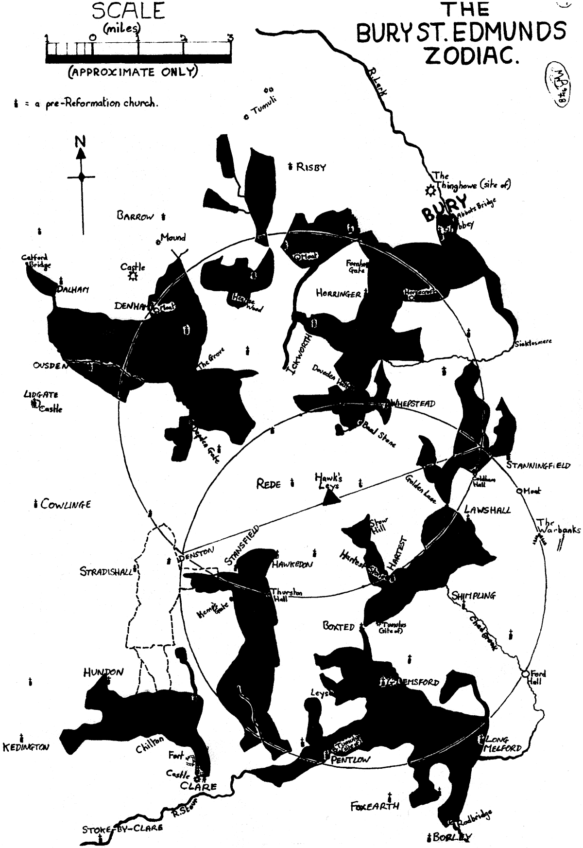
This zodiac is named after the town of Bury St. Edmunds not because it occupies any major position in the pattern, but because it is the largest centre of population in the area, and possesses the ruins of one of the great medieval abbeys, which for a long time was ranked in importance second only to Glastonbury. The zodiac itself is situated in the NW sector of Suffolk, the land of South Folk of the East Angles. Geologically, the northernmost edge is in an area called the ‘Fielding’ (so-named because it still lay in open fields long after the other lands had been enclosed), whilst the rest is in the ‘clay loams’ belt. The highest ground in the county (over 400 feet above sea level) occurs close to the centre of the zodiac, around Rode. It is totally within the ancient Liberty of St. Edmund, and mostly in the Hundreds of Thinghoe and Babergh, with a part in Risbridge, and it is the area of the ‘heartlands’ of the Iron Age Iceni people, whose tribal headquarters were slightly to the north and west, around Icklingham and Ixworth. It is virtually bounded to the north (apart from half of the Pisces figure) by the Roman link road from Bury to Newmarket, on the east by the Roman road from Ixworth to Long Melford, and on the south (apart from the legs of Leo) by the Roman road from Long Melford through Clare. Further to the west passes the Icknield Way, to the east Dr. Rudge’s ‘Conglomerate track’ and down from the north-east comes the Peddars Way.
This is a Type A zodiac (after Nigel Pennick), with Leo in the south and Capricorn north. It has eleven figures not counting the ‘guardian hound’ (although a possible ‘extra’ effigy in Gemini is mooted later). It seems unique in that only the head and horn of Capricorn is represented. Here follows a basic description of each figure, commencing with Aries and travelling clockwise, as per convention:
ARIES: takes the form of the kneeling ‘paschal’ lamb, with its legs tucked underneath its body, and the head turned over the right shoulder, facing west. The tip of its head is at Barrow crossroads, and a continuation of these roads could form horns, as in the Alton Zodiac. The entire body of Aries is formed by roads and tracks, with the tail partly delineated by the River Kennet, in the Hawson Hills. The tail’s tip at Catford Bridge, one of the zodiac’s three gates by water. St. Mary’s church, Denham, is on the beast’s snout, Hargrave St. Edmunds on its throat or upper chest, and Ousden St. Peter’s on its hind legs.
PISCES: This figure is in the form of three fish (one possibly a whale?), as at Glastonbury, Nuthampstead etc., in the area west of Little Saxham and Risby. They are formed by tracks and a stream, and the underside of the lower small fish is marked by an ancient way called ‘Shaker’s Road’.
AQUARIUS; Presumably an eagle or phoenix with head pointing south and wings curved round, centred on woods and estates of Great Saxham. Its head and beak are Hearse Wood, and within its westerly wing is Wilsummer Wood. St. Andrew’s church and Frizzelers Green are upon its easterly wing. Its outline is a reconstruction from old maps.
CAPRICORN: The head and neck of a goat facing west, with a single horn pointing towards the zodiacal centre. The underside of the neck and head are formed by tracks and parish boundaries, whilst the top of the neck and east side of the horn are marked out by the River Linnet. The rest of the horn down to Ickworth Park (where the Linnet rises) is formed by a parish boundary following the edges (formerly) of Dairy Wood and Twist Wood. This figure has St. Nicholas’s church, Little Saxham, on its snout, and a large moat at Dairy Farm for an eye. On the neck, Westley has two churches, but one is modern. The other, now in ruins, was dedicated to St. Thomas a Becket. A continuation of the neck eastwards across the developed area of Bury is possible, ending in a classic sea-goats tail at Great Barton, but this would result in a totally disproportionate body. However, the topographical evidence for a sea-goat is still very strong. A number of Roman wells has been discovered near Westley. Further east, the body would contain the exceedingly ancient Tayfen Meadows. Just NE of Bury are some bodies of {92} water, which, on the modern map, look like present-day reservoirs; but on 18th and 19th century maps they are called the ‘Mermaid’s Pits’. Where the tail is formed at Barton is an ancient well. Coupled with this, just outside Bury’s north gate is the site of the Thinghowe, from which the Hundred derived its name.
SAGITTARIUS: This figure is that of the centaur-archer, which as far as I know only occurs elsewhere in the Ongar and Pendle zodiacs. He faces west with arms outstretched, the left holding a curved bow. Both human and horse sections are delineated by a combination of road, track and parish boundary, but the entire rump and back of the tail by the River Lark, down to Sicklesmere (which name is very appropriate, since at this point the tail does resemble a sickle). The front leg merges into Capricorn at Westley Bottom, while the hind hoof is lost in Bury. On this leg can be found another of the zodiacal gates by water, namely the magnificent Abbot’s or Saxon Bridge. Also here are the ruins of Bury Abbey (St. Edmund), the cathedral church (St James), and the church of St. Mary. There is a moat upon his right arm, and one upon his brow, and his left arm contains Ickworth St. Mary’s church. On his chest is the church of St. Leonard, and further down, Fornham Gate, the first gate by land to the zodiac. The homestead called Horsecroft sits neatly upon his horse’s back. The northern horn of his bow doubles for the horn of Capricorn, and is in the area of what was once Little Horringer (St. Peter’s church here was pulled down sometime after 1548). Horringer was once called Horningsherth, one possible meaning of which is ‘the ploughed land at the horn’.
SCORPIO: Here is the traditional scorpion, bearing more resemblance to that at Nuthampstead than to Glastonbury. Most of the body and claws are made up of roads and tracks, but a tributary stream of the Lark outlines the east side, down to ‘The Wash’, where the Lark is bridged at the tip of the sting. Stanningfield church (St. Nicholas) is by its right claw, and one meaning of the village’s name could be ‘the field of the stone’. The scorpion holds Coldham Hall in its jaws, and there is a legend of a tunnel from here to Lawshall Hall, on Virgo’s skirt hem. Coldham was the family home of Ambrose Rokewode/Rookwood, one of the ‘Gunpowder Plot’ conspirators. Near the left claw used to be ‘Jacob’s Well’, whose traditional origin, not detailed here, could be of geomantic significance.
LIBRA: Presumably the dove normal in terrestrial zodiacs, fairly close to the centre and with a ‘host’ in its beak. This figure is composed mainly of roads and tracks around the parish of Whepstead. Plumpton Wood serves for its host. Whepstead church, with its unique dedication to St. Petronella, is on the right-hand wing, and Doveden Hall with moat on the edge of the body where contiguous with the head of the centaur. Upon the head of the bird is marked ‘Cross, rems. of’, on what is termed ‘Stonecross Green’. However, close inspection of this object shows that it could never have been the base of a cross. Indeed, the local name for it is the ‘Baal Stone’, and tradition alleges that it was a sacrificial stone.
VIRGO: This effigy corresponds quite closely with the hooded, female figure on most other zodiacs. She lies, almost on her back, with arm stretched out towards the centre, holding the conical wheat-sheaf or corn dolly at Stow Hill, ‘stow’ often meaning ‘holy place’, sometimes in connexion with fertility. Her body is formed alternately by tracks and streams, between Boxted and Lawshall. The tip of her hood lies on Boxted Hall, with Lawshall church (All Saints) on the hem of her skirt. Golden Lane runs towards her feet. The centre of this figure has to be the curious and magical village of Hartest (‘the hill or wood of the stag’) at her heart or breast. Hartest is strange in many ways, not the least being its position in a very deep dale, which is unusual in flat Suffolk. All Saints’ church is very near her breast, but nearer still, standing on the raised village green, is the Hartest stone. For various reasons, I doubt the local tradition that it was moved here from the nearby Somerton Hill in the 18th century for commemorative purposes; however, the ensuing ‘erotic debauch’ is interesting in that not only does it possibly hold memories of a pagan fertility rite, but that it also has an exact parallel in Norfolk. A tumulus once stood at the nape of her neck.
LEO: A rather good figure of a rampant lion, similar to that at Glastonbury. Also, just as the underside of the Somerset Leo is delineated by the windings of the River Cary, so the Suffolk beast’s belly is outlined by the River Stour. The rest of its body is formed by the usual tracks, roads and boundaries, except its mane, which is etched out by the River Glem. Boxted church (All Saints’) is on the tip of its long {93} ear, while its eye is marked by a conspicuous knoll of land. Round Wood is on the snout, a place called ‘Leys’ on the lower jaw, St. Mary’s church, Glemsford, on the chest, and Long Melford (Holy Trinity) on the haunches. The Roman road through Melford, whose continuous habitation has been traced back to Belgic times, runs the complete length of the lion’s rump, down to the third zodiacal gate-by-water, called Redbridge. The beast’s hind legs are the only portions of the zodiac which cross the county boundary into Essex, and Liston church is on the right heel. On the foreleg is Pentlow church, and close by, the site of a prehistoric mound (O.E. Pentelawe: Penta’s barrow).
GEMINI: This takes the form of a giant, hooded figure, facing and pointing west. He is outlined by the usual means, but his profile is immediately obvious on the map, being composed of two very long, sinuous and unusual tracks from Cavendish towards Stansfield. St. Mary’s church, Hawkedon (‘hill of the hawk’) is on the tip of his hood, All Saints’, Stansfield, on the cowl or face, the moated Haughton Hall on the leading foot, and Thurston Hall upon his shoulder. At his chest is another zodiacal land-gate, called ‘Kemp’s Gate (O.E. kemp: cempa = warrior). At first glance he would appear to be either running or dancing, but a closer inspection of his trailing foot reveals him to be the sacred king, the ‘bull-footed god’, also known as Mercury, Wayland, Vulcan, Hercules or Orion. It is mainly this last fact that leads me to suppose that the second Gemini figure, slightly to the west, is a spurious, ‘phantom’ twin, and is not to be considered as part of the original zodiacal scheme. Also, the two figures seem incompatibles one is in a state of obvious motion (whether running, dancing or limping), whilst the other is rigidly static. It is also severed at the knees by the hound. Not far from here, but actually on the hound, is Chilton (OE: the knight’s tun).
TAURUS: A fine bull’s head with single horn and hoof, facing east. Made up solely of roads and tracks except for the hoof, which is reconstructed from wood-boundaries on an early 19th century map. Where he meets the figure of Aries is the Grove, and a half-mile north from this used to be the place called ‘The Bull’. Where the head joins the hoof is Depden Gate, the final gate-by-land into the Zodiacal area.
THE HOUND: The circle of the zodiac has a guardian hound, facing west, with paws outstretched towards Kedington, whose church is built on a pagan site, and whose churchyard contains 10 elms, under each of which, legend says, lies a knight. In this pattern, he seems rather too close to the other figures, but this could be because of the position of Gemini. Also, he is obviously meant to be watching the borders of Suffolk. On his ear is Hundon church (All Saints’), on his rump St.Mary’s at Poslingford, and at the tip of his tail, the remains of Chipley Abbey. The most significant features are by his hind leg: the Wentford, the hermitage, the church of Ss. Peter and Paul, Clare Castle, and the Iron Age hillfort of Clare Camp, also called Erbury or Houndswall.
The centre of the Bury Zodiac is, like that at Nuthampstead the remains of a wooded equilateral triangle, here called ‘Hawk’s Leys’. Around this, and touching or enclosing every figure except the hound can be constructed the twin circles of a vesica piscis, where the diameter of each circle passes through various significant points. The whole structure of the zodiac is underlain by geomantic distances expressed in whole number multiples of the ‘x’ unit (discovered by Michael Behrend), where ‘x’ = 295.3 metres. The diameter of each circle is 21x. Extended eastwards from the centre, the main E–W axis of the vesica hits Haughley Castle, at a distance of 75x. Using this as a radius, it is then possible to draw a ‘great circle’ around the zodiac, touching no less than 14 important geomantic sites, including the easternmost vertex of the Cambridge Vesica (discovered independently by M. Behrend). Also, the main axis extended westwards passes through the Hadstock ley centre, another major point on the Cambridge pattern and on an extended radius of John Michell’s Whiteleaved Oak decagon. I have no space here to list further examples of geomantic relationships within and without the zodiac, except to note one last important detail: from centre to centre, the Nuthampstead and Bury zodiacs are exactly 150x apart.