Journal of Geomancy vol. 2 no. 4, July 1978
See also the reply from C.A.E. O’Brien in this issue, and the rejoinder from Bill Clark in issue 3/2.
{96}
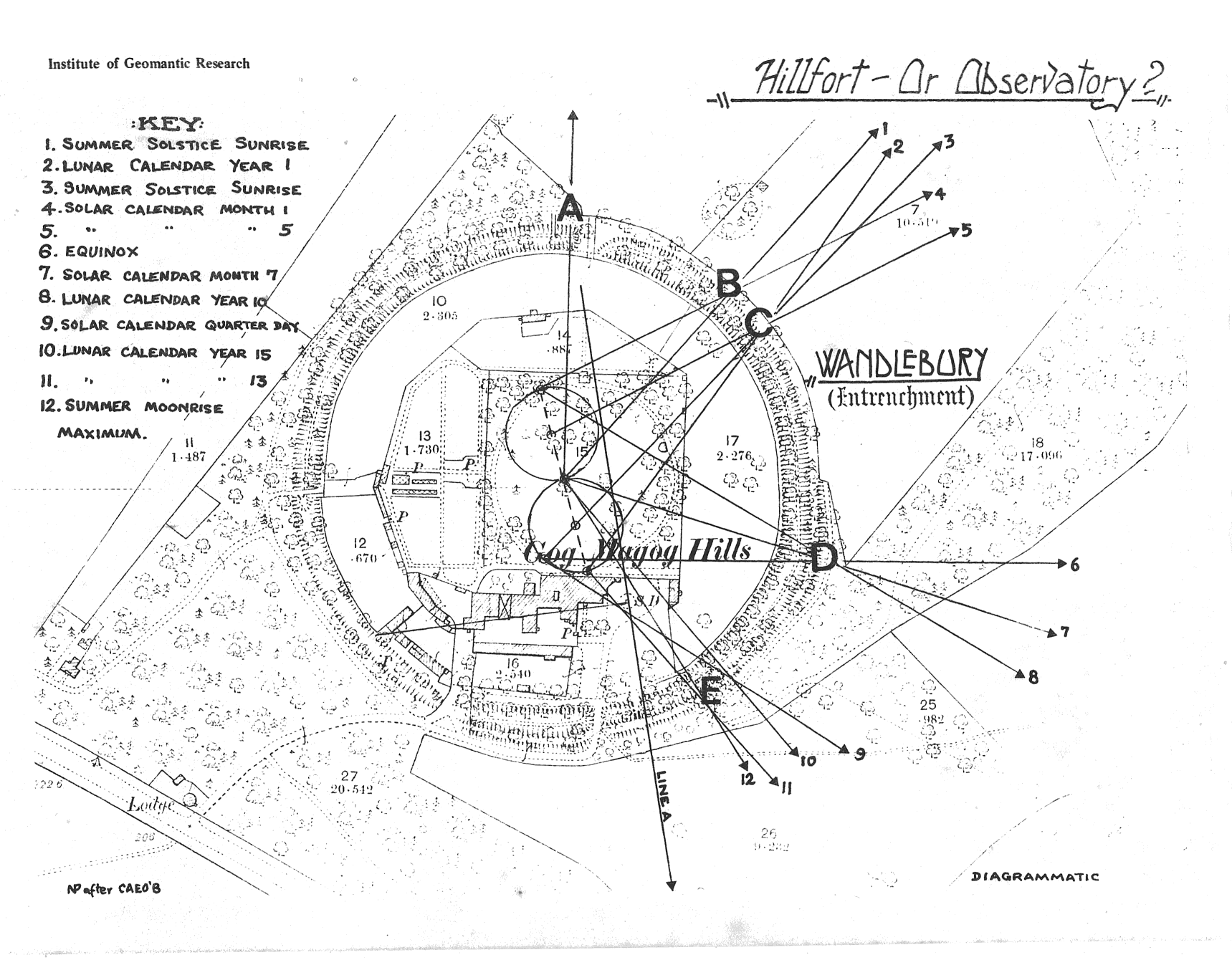
Mr Tim O’Brien of Thaxted, the retired head of an international oil consortium, has worked for several years on his theory that Wandlebury originated as a solar and lunar observatory, and not as an iron age fort. He claims that by a chance discovery of one straight line of great significance, which he calls Line A, it linked Wandlebury with Hatfield Forest to the south, site of another great earthwork. Between the two earthworks, he maintains the line passes through several well-known stone and earth landmarks in Essex.
On March 19th of this year an article The Wandlebury Enigma Solved was published in the Sunday Telegraph Magazine, written by Mr. O’Brien but it would seem that there are certain anomalies that should be clarified today in order that certain obvious discrepancies are not to be perpetuated in any future serious studies on Wandlebury. These anomalies are even more widely exemplified in his recently published treatise An Integrated Astronomical Complex of Earthworks at Wandlebury and Hatfield Forest from the Third Millennium B.C.
A lot of emphasis in his works is placed on the positioning of the sighting holes as the ‘gaps’ or ‘dents’ (listed A–F by O’Brien) in the outer bank – extracts from his article state thus:
“… Each of the dents in the Wandlebury bank has several astronomical purposes. From the exact centre, for instance, there is one pointing towards the North Star. Another points the way to the midsummer sunrise, and another to the lunar summer maximum …” (p. 24)
“… Cut into the bank and still clearly visible are six indentations. The dents” O’Brien says “were used for observing the movements of the sun, moon and stars” (p. 24).
It is known from old workers on the estate at Wandlebury that at least four of the gaps were created at the time when the mansion house stood on the site. This house was demolished in 1956.
Gaps A and D are flint and brick-lined paths.
Gap B is a small causeway and was constructed to give access to the Shooting Shed from the inner circle.
Gap E was used to get a horse and cart through to empty a septic tank situated in the ditch.
Gaps C and F are very hard to define as gaps.
At this stage we feel it necessary to quote more fully on O’Brien’s theory regarding Gap B, due to his implication that it is comparable with the Heel Stone entrance at Stonehenge.
“… Gap B: a 5 m wide, U-shaped depression, worn down to the level of the outside terrain, and aligned with a 3 m wide causeway across the Outer Ditch to the Inner Circle. This causeway is now less than 2 m above the Ditch at its middle, having suffered considerable erosion as a path to the interior. Hartley dismissed this entrance as ‘modern’, presumably meaning not pre-historic, but advanced no evidence for this conclusion – it has not been excavated. The site lends itself to a contrary argument in that the total volume of material in the causeway is now of the order of 60 m3, and before erosion was considerably more. There are no signs of quarrying in the vicinity for the chalk-filling, and, if modern, the material would have been derived from the destruction of the interior ramparts in the 18th century. But that material was used for a 50 m wide infill covering of the Ditch in the northern sector, only 60 m distance away. The addition of a second, adjacent, crossing, at that time, appears improbable.
As only one entrance to the earthwork was recorded in mediaeval times, and the causeway and Gap align, and since its eroded and compacted nature is comparable with that of the Outer Bank, there is a case for considering the causeway to be the original entrance. It would then be comparable with the Heel Stone entrance at Stonehenge …”
In order to give more substantiating evidence that the path is modern, and not just to rely upon the spoken word, we would point out that the present Warden of Wandlebury dug a hole right through the causeway over the ditch and brought up clinker at all levels until the flint path was reached in the bottom of the {97} ditch (this path was constructed by the Duke of Leeds in the mid 19th century, and thus proves beyond doubt that the Causeway was constructed after 1850).
There is at least one other gap on the western side of the site that Mr. O’Brien has ignored.
When Mr O’Brien was confronted with this information by the Cambridge Evening News reporter, Mr. Rodney Tibbs, in April, he said he thought some of the gaps in the earthwork might be modern, but they would have occurred in positions where gaps existed before. The gaps to the South west Mr. O’Brien dismissed as ‘modern’ and leading to the stables.
A linear ditch would also seem to have some significance according to Mr. O’Brien – page 3 of his treatise maintains:
“… A radially-aligned, linear ditch, dug into the underlying virgin soil, was uncovered by the excavators of the defences in 1956, but its purpose could not then be determined. Its alignment is now shown to be that of the Summer Solstice sunrise, and it is suggested that it may have been used as a water-level in the construction of a zero-attitude false horizon …” (p. 3)
Page 8 of the treatise states:
“… In the area stripped by the archaeological survey, in the otherwise undisturbed land surface below the site of the inner rampart, there was found a Linear Ditch described as ‘aligned almost radially to the perimeter of the fort’. The full extent of the Ditch could not be uncovered, but a length of 25 m was proved. It became wider and deeper towards the centre of the earthwork, the bottom falling 0·5 m in 21 m to a maximum uncovered depth of 0·9 m.
The important feature of the Linear Ditch is its alignment, which from Hartley’s plan has an azimuth of 47°·0 ± 0°·1. This azimuth is compatible with a level sighting on the upper limb of the rising sun at the Summer Solstice over the greater part of the third millennium B.C. If used in connection with such a sighting, the Linear Ditch could have formed a level water-base from which could have been constructed an eye-level false horizon in the Outer bank …” (p. 8)
A more probable explanation is that the ditch was a feed to the presumed dew pond (found to be lined with clay) which it also lines up with.
Since the article appeared, many people have visited Wandlebury seeking an arrangement of stones as shown inset on p. 23 of the Sunday Telegraph Magazine. These stones are in Ireland. There is, however, the question of Mr. O’Brien’s ‘Wandlebury Stone’ itself, viz:
“… At Wandlebury, for instance, O’Brien constructed the largest triangle which could be accommodated with one line pointing toward the summer solstice gap. The right angle was on his line A, and to his amazement the spot was marked by a stone set in the ground” (p. 24)
What evidence do we find for the ‘stone’ from the treatise?
“… Line A passes through a stone set deeply into the lawn at Wandlebury, so placed as to mark the right angle in the largest possible construction of a 3:4:5 Pythagorean triangle …” (p. 3)
Another reference occurs on page 39:
“… (i) Wandlebury Stone – lies buried in the lawn of the gardens laid out within the Wandlebury Inner Circle, with its top just below the surface. It has not been excavated for obvious reasons, but has been probed to a depth of 0·3 m. The top is flat, of 260 cm2 area, and one face slopes downwards at an angle of 50° for as far as the probe could reach. The stone is a greyish-white, shelly limestone and is not indigenous to the chalk of the Gog Magog Hills …” (p. 39)
Alas, this ‘stone’ is simply a cement covered brick plinth, being the base of a flower vase originally set in the ornamental garden of the Old Mansion House – the Warden, by probing, has found others. Mr. Tibbs pointed this fact out to Mr. O’Brien, who then stated that it was definitely shelly limestone and that he had taken a piece home and looked at it under the microscope. (A request was made by Mr. O’Brien (1/7/75) to carry out a rather more detailed and careful theodolite and tape survey of the Earthwork – he said he would ensure no damage {98} was done to the structure or its surrounds. Permission was not given to remove pieces of the ‘stone’.)
When Mr. Tibbs returned to Wandlebury, he watched the Warden remove a piece of the ‘stone’ – a thin layer of concrete and a sharp, easily recognized outline of Burwell brick – clearly modern.
A further stone seemed to have some importance, as page 17 of the treatise states:
“… Partly because Avebury has a roughly similar design, and partly because it was reported by the Warden that a large, cavernous hole, capable of seating a monolith, had been discovered by him while digging a flower bed in the northern part of the Inner Circle, it was decided to construct an exactly similar North Circle with its centre on the extension of the southern diameter IV – III – GC, such that GC (outer bank geometric centre) was common to the circumference of both circles …” (p. 17)
The expression ‘capable of seating a monolith’ was used by Mr. O’Brien to the Warden when he saw the Warden searching for a drain on the South side of the Inner Circle, not the North. The hole the Warden found turned out to be a brick-lined tunnel running from the Old House to the outer ditch and believed to be part of the Old Mansion House sewerage system. The Warden disagreed with Mr. O’Brien at that time over his theory that the hole could have seated a monolith.
The main reason why we have felt driven to write our comments in great detail is the fear that perhaps in 200 years or more, this Treatise and article will be turned up from the Archives and hailed as proof of an Astronomical Complex at Wandlebury, based on the evidence cited today, when it could be presumed and quoted that “the Wandlebury Stone has disappeared, but was known to have existed in 1978, etc. …”!
Mr. O’Brien’s reply to this article is on p. 100.