Journal of Geomancy vol. 2 no. 2, January 1978
Translated from J. Hopmann, “Ortungsuntersuchungen”, Germanien, 1935, 198–202. In this Web version I have amended the translation of ‘Schiefe der Ekliptik’ to ‘obliquity of the ecliptic’, and the title of Röhrig’s book to Heilige Linien durch (not über) Ostfriesland (Hopmann’s error). – MB, December 2015
{34}
Although I can assume that readers of this journal are acquainted with the work of Wilhelm Teudt and its developments, I should still like briefly to recount its history. Several decades ago the Bonn archaeologist Nissen carried out extensive studies on the orientations of Greek, Egyptian and other temples. At about the same time the major English astronomer of the turn of the century, Sir Norman Lockyer, was studying the same area. He too was concerned with Egypt and Greece, but in addition with the prehistoric megaliths of his homeland, those in Scotland, Wales and Brittany. Although in many respects his conclusions have today been superseded, it would still be worthwhile checking them over thoroughly, which however only a researcher familiar with the sites could do. As far as I know Teudt developed his own ideas completely independently of these two. He began with essays in Mannus 19271, which gave rise to a lively and not always pretty debate. His comprehensive account in Germanische Heiligtümer sparked off many more extensive researches into orientation, which extended over the whole of Germany. Academic circles remained throughout either silent or hostile. Now we have entered a new phase of research. It is occasioned by S. Reuter’s splendid book and by the researches of Rolf Müller and myself. In what follows I shall give an outline of how I see the present state of research into astronomical orientation. For this I shall have recourse to a series of examples that are fully substantiated elsewhere.
S. Reuter’s book Germanic Astronomy will receive full evaluation from other points of view. As an astronomer, I would like to point out expressly that up to now I have not found one astronomical error in the work, and I am astounded at how brilliantly Reuter has gone into astronomical phenomena in the heavens of Norway and Iceland. To be sure, here and there the calculations could be more precise, for example in the analysis of Oddi Helgasson’s numerical series. This however only shows unchronicled German science up more favourably than ever. The orientations that Reuter has located in written sources in Iceland etc. are for their part a welcome bridge between us and prehistoric orientation.
Our ancestors must somehow have read the solar calendar from the heavens. All that we can now demonstrate is the evidence of such practice, e.g. in the form of megalithic sites. Whatever else our ancestors possessed – wooden stockades, ceremonial implements – is lost. Which astronomical alignments would then be significant for them? Most importantly the north–south line, the easiest one to determine, similarly the east–west line, and then the four alignments of summer and winter solstice sunrise and sunset. The moon must certainly have marked the divisions of time for thousands of years. Evidence for this is essentially more difficult, and is still forthcoming. Finally, for determining the calendar they could use the brightest fixed stars, although not the planets.
The prime example of solar orientation will always be the great circle of Stonehenge. It has always been considered as such. As precisely calculated by Lockyer, the system dates from about 1600 BC. I too took Stonehenge as the starting-point of my investigations. With new values for the variation in the obliquity of the ecliptic it was possible – details here, as in the following sections, are too lengthy to relate – to repeat Lockyer’s calculations with the following result. {35}
If one takes the bearing of the great ceremonial avenue as the basic alignment, or else, which is practically the same thing, uses the earthworks a kilometre away, then accordingly Stonehenge may well have been built in 1500 BC. It is not possible to be more exact, but 1000 years before or after would also be permissible. In this case only the upper bead of the sunrise would be visible. The reasons that the date is imprecise is because of the very slow variation in the obliquity of the ecliptic. The sunrise at the solstice would not alter, even over 1000 years, by as much as one sun’s breadth, yet we must grant the ancients a tolerance of 2°–3°, which is four to six diameters.
An obvious successor to the subject of Stonehenge is that of the relationships between the Externsteine. In what follows I will briefly sketch the results of my exact survey in the spring of 1935. I was prompted to undertake the work by the fact that two of Prof. Andree’s assistants took independent compass-bearings of the north–south line and with it the former boundary of the sanctuary. The two results were demonstrably different despite all precautions. This is not surprising to the expert; on a German steamship once I saw the compass-error checked against the sun several times a day. Here I would warn all ley-hunters not to take definitive bearings by compass. Four hypotheses were entertained about the orientation of the sanctuary. First of all, the present axis through the round aperture already identified is to be aligned with the northernmost moonrise. This bearing is given also by a site of a former megalith. It was claimed moreover that the solstice was formerly visible from the sanctuary. At its consecration as a Christian chapel the walls would have been realigned away from this heathen orientation. Finally, a megalith may have stood on the Steintischberg (a hill – Trans.), which lies approximately 1 km south-east of the Fissenknick mill, and would have served as a distant reference-object for the bearing from the sanctuary to the solstice.
The correct verification, i.e. a survey, necessitated several complete days of fieldwork with measuring tape and theodolite, and previous lengthy calculations. I beg leave to omit the details.2
The result is as follows. At the birth of Christ the upper bead of the solstice sunrise lay exactly 1½ times the diameter of the sun to the right of the summit of the Steintischberg. In 770 AD the error had increased imperceptibly, whereas in 2000 BC it was only one half the sun’s diameter. In the face of these minute variations it is of course impossible to give a specific date for the time the supposed bearing was taken. Teudt himself did not do so. But it should be noted that late stone age graves were placed in corresponding trenches on the top of the Steintischberg. It is surely easiest to lay out a near bearing to the summer solstice in this manner. When one stands in the sanctuary facing the solar aperture, it is necessary to go to the left-hand corner of the niche in order to reach the solar orientation (the error is only 1 cm). This is precisely the earlier axis of the sanctuary according to Breitholz’s reconstruction. Of course it is not my place here to judge the adequacy of his other theories.
As a distant R.O. to the northern part of the moon’s travel, it is the Fissenknick mill that fits, much better than the Steintischberg. At the birth of Christ the error is only one half the moon’s diameter and for 1000 BC there is no error at all. The main difficulty here is the historical side of the orientation. In the Steintischberg we do have an enormous man-made pile, whereas near to the Fissenknick mill as yet no prehistoric remains have been found. {36} As a near bearing neither the present-day nor the reconstructed axis of the sanctuary merits consideration. In our heavens moreover (in contrast to the situation in Norway, cf. Reuter), the northernmost point of the moon’s path is seen only three or four times in 19 years, and then only subject to the sky being clear. One would do well, then, to consider a lunar orientation in reference to the Externsteine only with the greatest caution.
Certainly developments have been promising vis-a-vis the presumed solar orientation.. And if elsewhere in ancient Germany an increasing number of identical or related phenomena are demonstrated, then the probability of star-bearings from the Externsteine will be greatly augmented.
One example of this sort of result can be found in the researches of R. Müller, of the Potsdam observatory, into the orientation of the ten stone circles at Odry in the Polish corridor.3 Müller has already carried out many of these investigations, particularly on the Inca sun-temples in Bolivia. His exposure of the alleged orientation of the Steintanz at Butow in Mecklenburg only makes his exhaustive researches into Odry more valuable. He shows quite conclusively that here we have a Germanic case of orientation onto the summer and winter solstices. The N–S and E–W axes appear to play a part in it. Here too no date can be fixed.
Teudt’s further astronomical claims include his system of “holy lines”. I do not need to explain here what they are. About a year ago, when I first started to analyse these things seriously, I saw immediately that the holy lines as Teudt conceived of them, for the Detmold district, in his well-known book, are untenable. Pure chance would have yielded an identical system. Most of all, the inadequate historical basis of so many orientated places is obvious, even when one has not seen them. This impression was strengthened last summer, when I made a field trip along a few holy lines. Without dwelling on the details, I can only say: The idea of the holy lines is sound in itself but urgently needs the detailed critique of a system of alignments. If, as we hope, such lines can be found elsewhere in Germany, then we shall not be surprised to find them in Detmold. At any rate, their substantiation will not be simple. The hints left us by Teudt in his own system must be accepted with thanks.
In these circumstances Dr. H. Röhrig’s work, Holy Lines through East Frisia, was most welcome, particularly because in it an attempt was made to substantiate individual points on the lines historically. Going over his results, I was astonished more than once at how much better Dr. Röhrig’s orientations accorded with strict scientific calculation than previous ones, which of course influenced me greatly in favour of his thesis. Nevertheless, strict mathematical analysis showed that even Dr. Röhrig’s impressive network could not be sustained. I attempted to draw up a system for E. Frisia. The result of almost a year’s work with a colossal number of calculations is briefly as follows.
If one takes only the seven great barrows in E. Frisia which still exist in part or whose site is known exactly, then these lie on the cardinal axes or the solstitial bearings so as to respond far more favourably to probability-analysis then is the case for Odry. Indeed, the site of an eighth hill which lay in the former district of Dollart {37} can be calculated. A network can provisionally be drawn from here out to five further sites in E. Frisia, sites whose pre-Christian existence is known. Mathematical juggling is necessary in order to extend the network, and on them include churches, chapels etc. whose history does not reach continuously back to the conversion of the Germanic tribes, but often leaves a gap of centuries unchronicled. On geological and historical grounds, serious objections immediately arise against the inclusion of these places, because of the many rises and falls in the coastal landscape. From nearly 80 points suggested by Röhrig, at most eight remain as evidence for an orientation to which I have added five additional distant ones.
In carrying out this research, a few points from higher geodesy must be kept in mind, along with some from astronomy. Details restrict me to referring the reader simply to the completed paper which will shortly appear in Mannus.4 I would most strongly urge all ley-hunters who wish to draw up such systems of alignment to take notice of the many hints and outright warnings in that article. Of the many linear systems known to me, I can think of only three worth more detailed investigation. Since in E. Frisia the solstitial alignments come into view only near the cardinal axes, precise dating is impossible here too. Nevertheless it can be shown that in the search for such dating one does not come into conflict with prehistoric findings, in that here as at Stonehenge and the Externsteine the upper bead of the sunrise was always used for taking bearings.
One further, extremely complicated, task which I set myself was the problem of the Sternenhof in Oesterholz. The result given in 1926/27 by Teudt and his astronomical advisers Riem and Neugebauer will be known to readers of this journal.5 In collaboration with Studienrat Dr. Altfeld6 I opposed these findings at the time and showed that others were possible. My new researches were occasioned by a query from one of Teudt’s most serious opponents. For a week the outcome was uncertain. There were phases in the work when Teudt seemed 100% wrong, then at last the following picture emerged.7
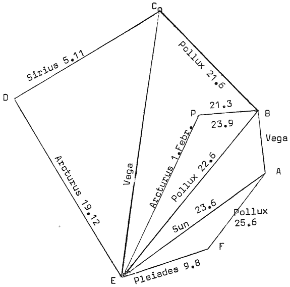
A new geodetic survey of the Gutshof that I carried out gave first of all better values for the azimuths of the earthworks and walls than was possible from the information given in the old land-register. The astronomical interpretation thus set up brought with it a confusing mass of star-identification. The necessity of these was shown by hexagons arbitrarily drawn up by my students, which were arithmetically substantiated just as Haus Gierke was. Nevertheless, a simultaneous identification of all six walls and of a seventh alignment for the Quellenhügel holds only for two dates. One is 1500 BC, which is approximately the earlier solution of Riem and Neugebauer, the other is 620 BC, in confirmation of our researches of 1927. The experiment with the arbitrary hexagons led to the consideration of relevant probability-calculations, which spoke conclusively in favour of the orientation.
The hexagon next to the Quellenhügel could be defined purely geometrically, by eleven postulates. It was in fact possible to establish these eleven desired bearings at Gierke, as is seen in the following figure (see next page). Still however both results, 1500 BC and 620 BC, remained possible, although the latter date was favoured. A new idea struck me, I took into consideration the corresponding rising- and setting-points of the constellations, and to my amazement found that almost all the bearings indicate the dates of major Germanic {38} festivals (summer and winter solstice, etc.). At any rate, the date 1500 BC did not compare well to the earlier one. From the viewpoint of prehistoric studies, much could be said against it which did not apply to the seventh century BC.
All in all, then, it seems reasonable to conclude that the Sternenhof was set up in the early Iron Age as a calendar-observatory. We do not know whether the centre portion of the earthworks is so old. Archival reports to indicate that the site is of eighteenth-century origin only the outside <see note>. Thorough excavation is absolutely imperative, and we hope to carry this out in the summer. At this stage I would make it clear that if no prehistoric remains are found, the astronomical theory of Haus Gierke will run into grave difficulties.
Some of my readers may not be in agreement with the above exposition, of that I am only too aware. But such is the scientist’s role. I would like once more to urge all those in favour of Teudt’s ideas to the greatest caution. With inaccurate bearings we all make fools of ourselves not only among the opponents of popular culture here and abroad, but also among serious researchers into German prehistory. It must be recognized that in Detmold the countless suggested orientations were not published until their associated problems were cleared up. Perhaps my researches, to which I refer the reader for details, will contribute to their elucidation. With such a plethora of lines one can only harm the orientation theory. That is what happened to those very inaccurate lines drawn by a gentleman from Berlin through the Bärenstein next to the Externsteine8. I would ask both friends and opponents of astronomical orientations to wait for the developments of the next two years, when perhaps the matter will be so clarified that we will be able to praise Teudt for the victory of his hypotheses.
{39}
| 1. | Mannus | 1927 | Ancient Germanic Astronomy Pts. I & II | |
| 2. | ibid. | 1935 | p143 | Bearings to the Externsteine |
| 3. | ibid. | 1934 | p289 | On the Astronomical meaning of the Arrangement of the Stones at Odry. |
| 4. | ibid. | 1935 | p373 | The Methods of Prehistoric Astronomy II: Holy Lines |
| 5. | note 1, II. | |||
| 6. | Mannus | 1927 | p236 | Analysis of the Hypothesis of an Astronomical Centre at Haus Gierke |
| 7. | ibid. | 1934 | p261 | The Methods of Prehistoric Astronomy I Haus Gierke |
| 8. | This reference is quite obscure; I translate the allusion as it stands. | |||
| <Something obviously went wrong when this sentence was typed up for the J of G. My translation: Archival findings that the layout dates from the 18th century mean nothing here, since trial excavations have already shown at least a double stratification, so that the 200-year-old documents apply only to the most recent building on the ramparts. – MB, December 2015> | ||||
W. TEUDT Germanische Heiligtümer
O.S. REUTER Germanische Himmelskunde
H. RÖHRIG Heilige Linien durch Ostfriesland
I cannot trace any of these. Anyone with any information please contact Prudence Jones c/o I.G.R.