Journal of Geomancy vol. 2 no. 1, October 1977
{9}
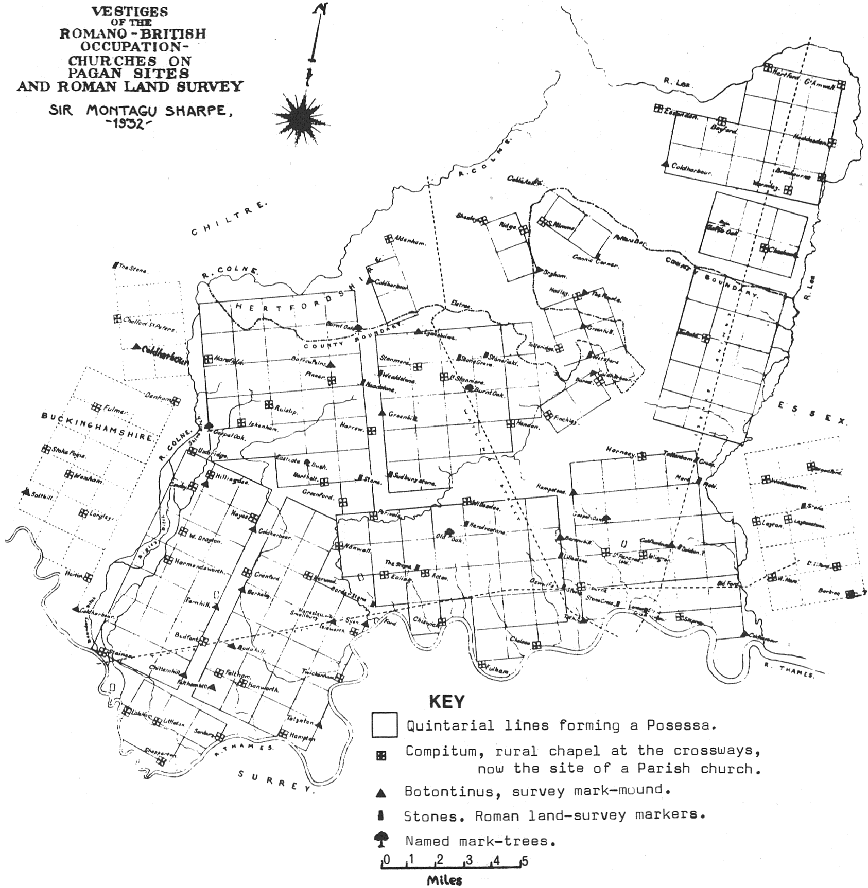
Throughout geomancy and surveying for land-measure, a recurrent theme is the maintenance of boundaries unchanged over the years. In Ancient Egypt and Rome, elaborate systems of surveying were devized to enable the guardians of the boundaries to keep them intact, and free from tampering and alteration. Draconian measures were enacted on those who were proved to have moved boundary-markers, and, in Roman times, a complex legal system grew up around the administration of land-measure. Even in the English Book of Common Prayer the Commination reads: “Cursed is he that removeth his neighbour’s land-mark”. The Roman survey-officials, the Agrimensores (literally ‘field-measurers’) had an organization comparable with that of the later Freemasons. Their training included tuition in cosmology, astronomy, geometry, orientation, sighting, levelling, land-law, boundary definition, allocation of land, mapping, scale drawing and recording.
The Agrimensores were practitioners of a profession which was at once both practical and religious. The original siting of the survey-points was carried out by Augurs, members of the college of official diviners who always observed the prescribed rituals when choosing a site. Once the boundary lines of whatever was being laid out had been drawn, they were maintained by ritual perambulation on certain sacred days of the year. The best recorded example of this in antiquity is the Roman festival of the Ambarvalia. In this festival, the Magister Pagi, an official appointed by the secular authorities and given priestly powers, led the people of the area in a procession around the boundary, visiting sacred groves and altars on the perimeter dedicated to Sylvanus. The ceremony was carried out with the intention of promoting crop fertility. A triple sacrifice, of a pig, a sheep and a bull, was carried out, after the animals had been driven three times around the fields. This threefold aspect reflected the threefold attributes of Sylvanus, guardian of the fields, the homestead and the Orientalis, the sacred grove on the boundary. Even when St. Patrick dedicated the site of Armagh Cathedral, he did so by a threefold circuit, so widespread was the practice.
On February 13th (or 23d) was the Terminalia, a festival in honour of Terminus, the protector of boundaries, in which the symbol of the god, a post or standing stone marking the boundary-line of a farm, was garlanded by the cultivators of the adjoining land, each on his own side of the post or stone. Terminus was originally an epithet of Jupiter.
Later, after Pagan worship was banned by edict of the Emperor Theodosius in 391, the perambulation of boundaries was applied to Christian church boundaries. Subsequently, during Rogationtide, the Ambarvalia became “beating the bounds”, a ceremony still observed in some places. Even during the Reformation, when fanatics wrecked churches, shattered tombstones, demolished crosses and desecrated churchyards, the custom was kept going. An injunction of Queen Elizabeth I on ancient general customs reads: “The people shall once a year with their curate walk about (ie. around – N.P.) the parish as they were accustomed … the curate in certain convenient places shall admonish the people to give God thanks …”.
These ‘convenient places’ were, of course, the ancient mark-trees, such as Gospel Oaks, Yew Trees etc., boundary mark-stones, crosses and their sites, all of them geomantically-sited remnants of a former age. The important positions of these trees and crosses are demonstrated by those which gave their names to localities, such as Selly Oak, Birmingham; Goff’s Oak, Hertfordshire; Bracon Ash, Suffolk; Twycross, Leicestershire; Charing Cross, Westminster; Clay Cross, Derbyshire; Neville’s Cross, Durham, etc.
The usual boundaries of most parishes must seem to the impartial observer to be irrational or even downright perverse. Examples of beating the bounds show this deviation from the ‘logical’ method of straight-line grids, which the Roman Agrimensores applied. Common features {10} of beating the bounds show the custom to be a degenerate remnant of ancient geomantic practice.
Before starting a walk, it was customary for each participant to cut a wand of willow, withy or hazel, for the purpose of striking boundary stones and other markers. Children in the party were always beaten at important landmarks, bumped against stones or thrown in ditches and ponds where the boundary intersected them. On boundary mark-stones and certain cross-shaped trenches on the boundary, the boys were stood on their heads, probably a survival from the days when human sacrifices were performed at these points when the area was first laid out. Ancient art often helps us out on this score. On the Gundestrup bowl, a figure is shown being cast into what is usually described as a cauldron, but which is more probably a ritual shaft. Such ritual shafts, the ‘arcae’ described by Sir Montagu Sharpe as markers in the Roman survey of Middlesex, have been found at Holzhausen, Bavaria; Long Wittenham, Berkshire and several other places. These rituals using shafts or wells were carried out into historic times at the Pagan Temple of Uppsala (see Journal of Geomancy info, page after cover). St. Victor’s martyrdom at Xanten in Germany was apparently such a sacrifice.
When a new building was started in former times, sacrifice was always made. Heinrich Heine writes: “In the Middle Ages the opinion prevailed that when any building was erected something living must be killed, in the blood of which the foundation had to be laid, by which process the building would be secured from falling; and in ballads and traditions the remembrance is still preserved how children and animals were slaughtered for the purpose of strengthening large buildings with their blood”.
These points had their human sacrifices to ensure that the ghost of the sacrificed should forever guard the site from interference, whether human or satanic. When the King of Ashanti built a palace in 1881, he had 200 girls killed so that their blood could be mixed with the mortar in order that the building might stand. Even today in Brazil, voodoo priests sacrifice chickens in the foundations of new buildings and at the erection of goalposts in football grounds. Similar rites were universal in Britain until well into the Saxon period. Although the Romans prohibited human sacrifice, it was reintroduced. The early Celtic Saint Odhran expressed his willingness to be the first to be buried on Iona, and offered himself to be buried alive as a sacrifice.
The obscure courses of boundary-lines can be demonstrated by some recorded features of beating the bounds in certain places. In an old house called Hornshayne at Farway, East Devon, where three parishes meet, the participants in beating the bounds ceremony made a small boy climb along a beam in the roof, in order that the boundary might be followed in its entirety. This ritual was last enacted on May 7th 1884.
At Coly House, Colyford, South Devon, there was a hole through which a child was made to crawl to follow the correct boundary. Both these buildings obviously date from a period when geomancy was no longer fully understood, yet the customary rituals were still observed.
These traditional perambulations were not restricted to England and Wales. In Italy, on Rogation Days, the boundary of each parish was walked and invoked with the Litania Minor to bring divine blessings on crops and households. In the Netherlands, a cross was carried around the perimeter. Breton ‘Pardons’ and Spanish and Mexican Holy Days also have prescribed ritual circuits, stopping at sacred sites such as crosses and holy wells, where the gospel is read. Formerly the beating the bounds of Lichfield Cathedral included stops at eight holy wells. It was held on the Feast of the Nativity of the Blessed Virgin Mary, September 8th, not at Rogationtide.
One common feature of all such processions, and, indeed, the scouring of hill figures or the cleansing of sanctified wells, is that the proceedings occurred on certain holy days, often the patron saint’s day in the case of wells, and Rogationtide in the case of boundaries. Figures in terrestrial zodiacs must have been perambulated in a similar manner on sacred days by the priests in charge of the figure and their inhabitants, preserving {11} the archetypal boundaries and redefining them at their appropriate symbolic times. In latter days these ceremonies may have been conducted under the auspices of the chivalric orders such as the Knights Templar, whose holdings in and around the Nuthampstead Zodiac have been shown.
In ancient times, all boundaries were held to be sacred, as they were believed to express a divine division of the world, vital components in the preservation of cosmic order against primeval chaos. To destroy these sacred boundaries was to disrupt the sacred order and to court disaster. “Urbs Camboritum”, writing on beating the bounds in the Cambridge Daily News in his “Cambridgeshire Cameos” column in 1895:– “In some country places the rustics believe there is some magic in this business, and that the crops show up better for this periodical farce, fondly fancying that the Goddess of Nature rewards the observance of the custom”.
This shows that there was still a belief, albeit scorned by the educated, still current at the end of the last century, that the wellbeing of the area depended on keeping its boundaries stable and intact.
Certain places were never profaned, even in time of war, a contrast with this barbarous age. To commit robbery or murder on the sacred highway was a capital offence under the Molmutine Laws of ancient Britain, hence the disproportionate sentences passed on the 1963 culprits of the Great Train Robbery who profaned the Royal Mail – a remnant of the Divine Right of Kings and Molmutine Laws. Areas such as market places, sacred raths and churchyards, geomantically-divined sacred sites marked in Christian times by crosses, or in Pagan times by stones, poles or trees, were bounded by unalterable lines, having special protection, both from the sacred and the secular authorities,
“No feud could be prosecuted on the place whereto people came to trade, nor within a certain radius from it … a stranger who came to trade was a guest, and he went on under this very name. Even the lord who had no scruples about robbing a merchant on the high road, respected the Weichbild, that is the pole which stood in the market place and bore either the King’s arms, or a glove, or the image of a local saint, or simply a cross. …” wrote Petr Kropotkin, in Mutual Aid.1
These stones, poles, maypoles and trees were situated at precise distances in precise geometrical relationships, as can be seen in the siting of consecrated points across the whole landscape. Sometimes, these markers were destroyed when a New Order took over, as when Charlemagne, who had changed the metrological system from the Roman one to the Pied du Roi/Toise system, destroyed the Pagan Saxons’ holy pole, Irminsul; or as when the puritans destroyed many ancient stone crosses. However, the site always retained its significance – to this day, distances from London are measured from the site of Old Charing Cross, now occupied by the equestrian statue of King Charles I.
The prime importance of place has been recognized since the dawn of civilization countless millennia ago. Scientific research of the present day is discovering some strange anomalies of place, at present inexplicable. The so-called ‘Bermuda Triangle’ has been quoted often as an example of a place-anomaly, though this has been bitterly disputed. Work carried out on navigational mechanisms in homing pigeons by researchers at Cornell University has revealed at least two anomalous sites in Massachusetts, from which their experimental birds cannot ‘home’. These are a fire tower in the forest at Castor Hill, from which the birds always fly off at 60° from the correct direction, and Hornell, where a similar phenomenon is observed. Aircraft instruments, too, often malfunction at this latter site.
Special places were expressed in terms of landscape modification, the most phenomenal of which are the Nazca and British ground effigies. The original laying-out of such effigies was probably achieved using a traditional surveying method – triangulation. That beating the bounds was the method of keeping British zodiacal boundaries intact is almost certain. However, because triangulation, not Roman centuriation (right-angled grids of 776 {12} yards/706 metres – 20 Roman Actus sides) was used, the beating the bounds ceremony would have been a Pagan British rather than a Roman one. The evidence of most terrestrial zodiacs’ non-Roman origin (with the exception of Professor Lord’s Pendle Zodiac, which is classical in conception) is demonstrated by the non-centuriated infrastructure, although a ‘Roman’ foot of 29·53 cm was used. This may be coincidental, and of much earlier date. It is certainly not Saxon, as some believe the Glastonbury Zodiac to be, as the Saxon foot is well documented at 33·53 cm, the Norman foot 29·777 cm, the Welsh foot 25·1 cm and the modern (1305) English foot 30·48 cm.
Much geomantic research has been expended on the detection in the landscape of direct straight alinements between ancient sites. Workers from the middle of the nineteenth century, such as Duke, Black etc.2 were followed by more exact surveys and hypotheses of Bennett, Allcroft, Lockyer, Ludovic McLellan Mann etc. In 1915, Mann wrote in Archaic Sculpturings:3 “A scrutiny with the aid of Ordnance Survey Charts of certain sacred areas, covering great stretches of ground both in Scotland and Ireland … demonstrate that locations marked by the erection of cairns and standing stones and by rock scribings and by prominent topographical features or points (often later chosen for the site of forts ) are arranged in an exact geometrical relationship”.
The work of Alfred Watkins4 is too well known to detain us here. His remarkable works, still the centre of heated controversy in the archaeological world, are read widely over 40 years after his death, and his out-of-print works are soon to be reprinted. Terrestrial geometry has burgeoned in those years, with the outstanding works of Heinsch5, Gerlach6, Behrend etc. as but a few examples of the many.
It is to be remembered that most of these ‘lines’ in terrestrial geometry are not lines in the Euclidean sense, owing to the curvature of the surface of the planet upon which they are drawn. The difficulties which this involves is demonstrated in the little-investigated case of long-distance alinements and macrocosmic geometry, where great circles are shorter distances than straight lines drawn on the map. A similar case occurs with verticality, where the line described by a plumbline in one place is not the same, i.e. is not parallel with, the line in another place. Such an example exists in the Humber Bridge at Hull, where the tops of the vertical suspension towers are two inches further apart than the bases. The basic problem is to evaluate what was actually done in the past, inaccuracies and all. Whether or not the principles used were inaccurate, superstitious or erroneous is irrelevant, or at least a different question. The only lines which can be laid out without the use of complex mapping techniques are those utilizing the line-of-sight principle, such as some of the alinements at Nazca. The complex mathematics shown by Dr Heinsch and Professor Thom to have been used in European megalithic works show that some exact science was practised. Thom’s work has now been accepted by most of the establishment archaeologists, though they still wish it could be disposed of. The ideas of Watkins and Heinsch, let alone Maltwood, can safely be dismissed and left to people like us who do not have public money at our disposal to further our endeavours.
Proponents of Victorian Science have, consciously or unconsciously, formulated the modern metaphysic of direct, unbroken progress from barbarous savage to enlightened modernity. Consequently, anything of the past is held to be more primitive and less sophisticated than today. Evidence to the contrary, though overwhelming, is glossed over and dismissed, an uncomfortable anomaly. Ancient astronomy and surveying were highly advanced, and constructional ability was high, but, because attitudes were different from those commonly held to-day, most modern observers of the academic school do not credit them with anything like the significance they deserve. With vast works like the terrestrial zodiacs7, the credulity of those who believe in the unbroken upward march of civilization is shattered. Scarcely being able to admit of the {13} academically-proven advanced mathematics of archaic megalithic circles, such authorities can hardly be expected to admit of a vision greater than theirs, especially a cosmic vision of millennia since passed.
Our approach is scarcely one which can convince these entrenched pundits whose psittacine knowledge admits nothing new. We are studying an earlier life-style whose existence we can only glimpse in fragmentary form through the practices remaining in what has come to be called folklore. Basically interdisciplinary, we study factors from a dozen ‘subjects’ which usually remain totally, and artificially, separate. The study of the landscape, which despite occasional listings by the Department of the Environment as ‘areas of outstanding natural beauty’, remains almost totally artificial, demonstrates that the received opinion that the ancients were little more than gorillas (in the obligatory skins and woad) is erroneous. The lore which even today surrounds boundaries, foundations and gateways is a remnant of a once much greater corpus of applied knowledge which it is the aim of the Institute to rediscover, evaluate and use.
*********
This article is an extract from a forthcoming book on Geomancy written by Nigel Pennick.
*********
1* Petr Kropotkin: Mutual Aid: A factor of evolution London 1902.
2* William Henry Black: Pioneer Geomantic Researcher (works of). Institute of Geomantic Research Occasional Paper 4, 1976.
3* Ludovic McLellan Mann: Archaic Sculpturings. Glasgow 1915.
4* Alfred Watkins: Early British Trackways. London 1922. The Old Straight Track. London 1925.
5* Josef Heinsch: Principles of Prehistoric Sacred Geography. IGR edition in preparation.
6* Kurt Gerlach: Various works in the National Socialist journal Germanien. 1940–3.
7* Nigel Pennick & Robert Lord: Terrestrial Zodiacs in Britain: Nuthampstead Zodiac and Pendle Zodiac. I.G.R. 1976.