Journal of Geomancy vol. 1 no. 4, July 1977
{79}
The whole question of the purpose of subterranea is most interesting and in the light of recent investigations into the subject with regard to Glastonbury, (see J. Geomancy 1/1) I was prompted to investigate tunnel legends in my own town and try to see if there was any verification for them.
So often these tunnels are taken to be synonymous with some last visible remnant of a ley-line. In my personal investigations I can find very little correlation between the two, except for the fact that several of these local features (the castle, mound etc.) are important ley-points, some facts of significance have emerged.
Before describing the extant tunnels if might be best to set the scene. Tonbridge is a very odd town with a Norman castle Saxon mound, a Norman church which had an earlier Saxon church formerly on the site, an old Saxon cross or gravestone near the church and a river called the Medway flowing through the centre of the town. Also the town had a priory, dissolved in 1539 as so many others were in that year, and this gave rise to the famous public school, one of whose pupils was Aleister Crowley.
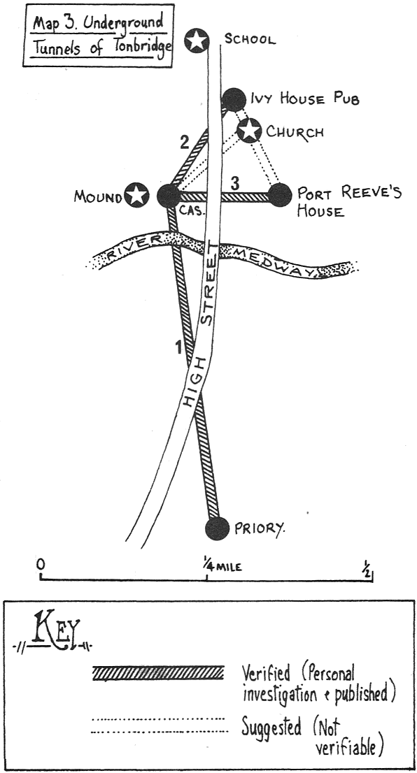
The most famous tunnel legend connects the castle walls with the Priory of St. Mary Magdalene, which is now almost completely destroyed being under the tarmac’d depot of National Carriers Ltd. The South Eastern Railway Company demolished the last walls of the Priory when building a new line in 1839 and an old picture of the priory contained in a volume from 1825 in the Castle museum shows it is a rather lovely building in a pastoral setting, with sheep grazing in the midst of the remains.
In this book the tunnel is described as rather amazingly running straight under the River Medway to the Priory. One would presumably have to cross this when travelling between the Castle and the Priory! One can only conclude that this is a possible memory of a ley-line and also wonder at such an old book reporting this tunnel without question, but so far I have not found any ley of more than 3 points to satisfy me regarding this.
The second tunnel links the Ivy House pub with the Castle. This also seems quite logical because the town once had ancient walls called the Fosse and a tollgate. Before it was a pub, the Ivy House was one of the town gatehouses, so communication between these two points, for defence or otherwise, seems quite natural. Strangely enough, there is an entrance at the very outer walls of the Castle, seemingly coming from nowhere as it is blocked up, but this must run somewhere underneath the Castle from the direction of the Ivy House. Proof of this is another blocked entrance in the pub cellar itself.
The third tunnel, according to the tenant of the Port Reeves House, (also now a pub) runs from the house to the Castle. This was also formerly another gatehouse and these usually were built at the edge of the town and developed into pubs I believe, because passers-through reaching the town just before nightfall would use them as stopping-off points for the night, especially as the town was on the main London–Hastings route. {80}
This tunnel, again verified by a blocked cellar entrance in the Port Reeves House is thought by the tenant to extend to the Castle, presumably for the same reasons as the Ivy House tunnel.
So, from all this one can conclude that the Castle was most definitely the centre of power in Tonbridge and an established interlinking network of tunnels were then in operation. There are also rumours of old tunnels between the Parish Church and the Castle, the Ivy House, Parish Church and the Port Reeves House all being linked by another tunnel, but at present these cannot verified.
There are tunnels underneath the Saxon mound as well for an unknown purpose, and rather strangely these are now rendered inaccessible by the Council as they are said to be ‘dangerous’. A well leads from the top of the mount at its centre, but I cannot investigate these tunnels as for reasons of ‘public safety’ they were blocked up in the late 1950’s. I await a proposed re-opening breathlessly, but the money for restoration is not yet forthcoming.
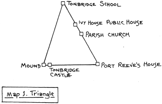
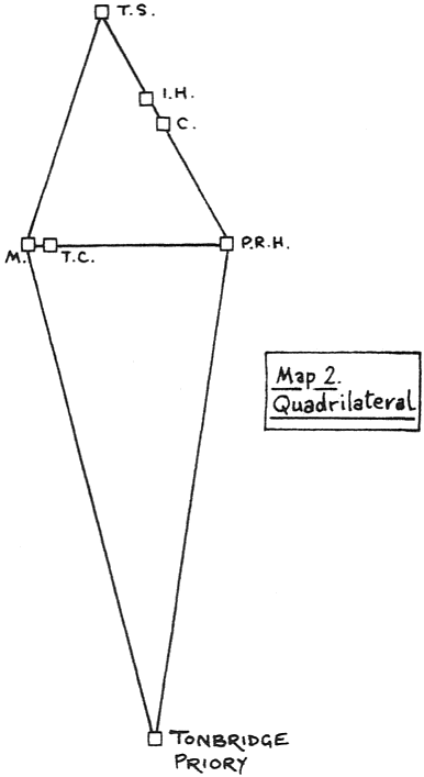
We now reach the most interesting part of the scheme of these tunnels. All the sites, except the Priory, are in very close proximity to one another, and in their half-mile extent form a triangle when all the sites are linked on the map (see Map One). I later found that if the priory south of the river was also linked into the schemata, a quadrilateral was formed (see Map Two). This was definitely a strange discovery from the geomantic point-of-view and also I discovered that the distances between the sites were nearly all multiples of 2 centimetres (2,4,8 etc.) on the map.
So, what can we conclude from this evidence? That somehow, for some as yet unknown reason, a system of underground tunnels were in existence in Tonbridge (probably much earlier than Roman times), and that these in turn formed a geometrical pattern evident from studying the local landscape.
Much has yet to be done however. I am looking for a tunnel link with Tonbridge School and its lovely chapel, constructed originally for the schooling of novices by the Monks and also Knights Templar connections with the Parish Church.