Journal of Geomancy vol. 1 no. 2, January 1977
{30}
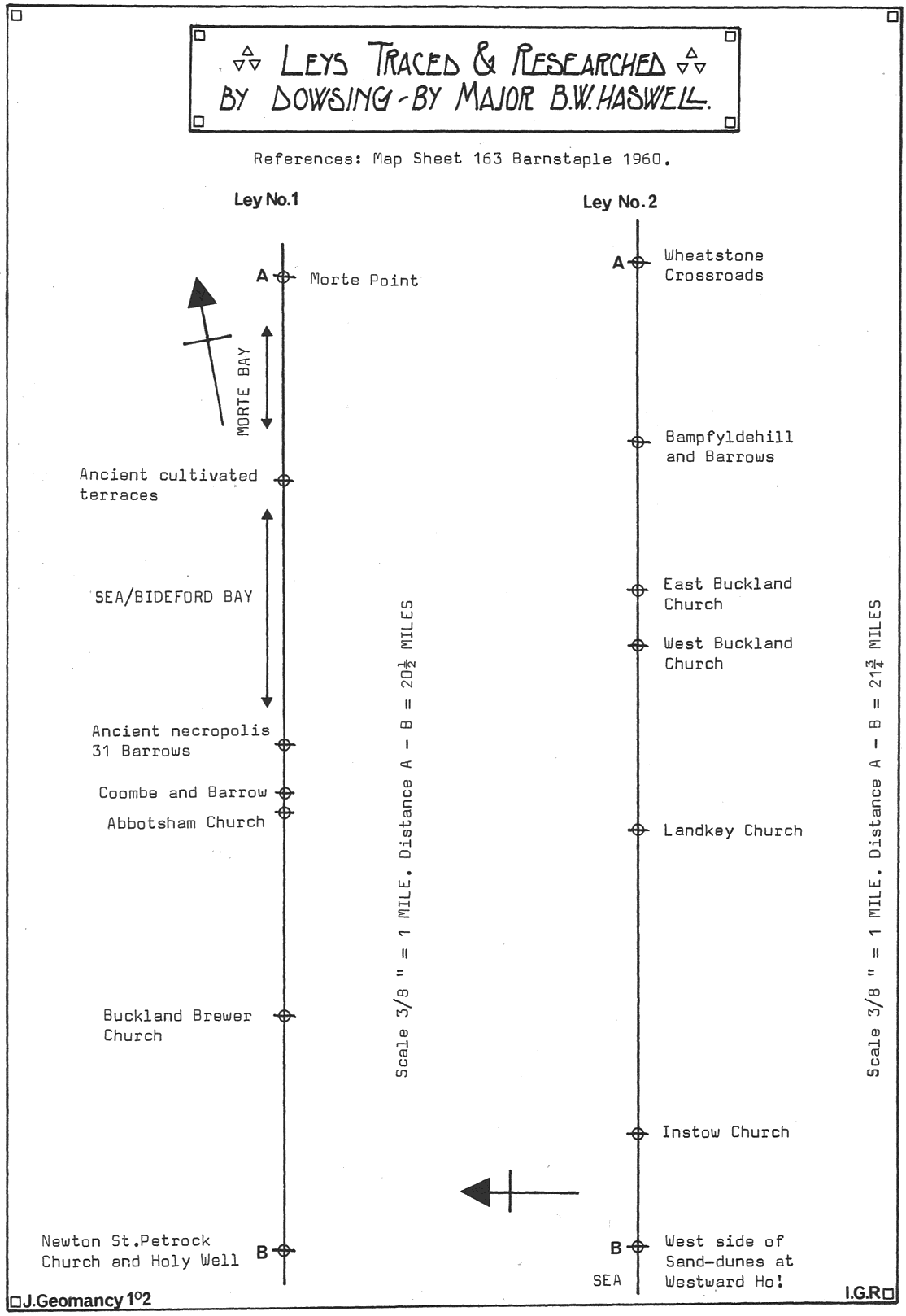
You will notice on ley No. 1 that I refer to an ancient necropolis site of 31 barrows. This site was discovered by me on private land. I completed three years’ work on this site in May 1976. It is now officially recorded by Ordnance, Department of Environment inspected, also it has been approved by the North Devon Archaeological Society inspecting body. It has also recently been approved and recorded by Devon County Council re Mrs. Miles, who is the Devon County Director of Archaeology, and staff tutor at the University of Exeter, in Archaeology.
This was all done by the method of dowsing, and is a concrete example of what a trained, and expert dowser can produce working entirely alone. Some of the barrows are visible, most are not. One long barrow is shown as a natural feature on the map, as is a barrow shown as a large hill! This hill is visible all round our area. It is one of the largest barrows in North Devon.
The two leys I have included have been traced by me. The method I use entails my walking fields, roads, Commons, and Moors. 25 miles is my limit in length to prove by dowsing that there is ‘something there’. In holiday traffic it can be highly dangerous walking on a road with a dowsing rod in your hands! Because of this latter fact and the traffic on our roads here I am delaying the check of three other leys on Exmoor until September. I could say now that they are on the sites on the Moor, because once I have established a ley over five miles I know it will go on through my map-projected ley, but I like to be able to say I have proved it and can demonstrate it if required.
Now as to one or two phenomena I have noticed. The leys are mostly one foot to three feet in width. I have one, however, which passes by the barrow at Coombe (Ley No. 1) which is 12 feet wide tapering as it proceeds north to three feet. I have never experienced any untoward effect in 40 years of this work until August 1976 when working on the Godborough Castle site. This ley passes to the south of Kenwith Castle and to the north of Godborough, by a few yards in each case. On the Godborough site it drained me of energy so much I could hardly walk!
Another puzzling feature is how leys pass out of or into field gates, it is too frequent to be a coincidence. Now I know that field gates have been recorded as being in situ as far back as 500 years in some archives, and recently I was talking to a young farmer’s wife who is interested in my work about this peculiarity and she informed me that cattle, when newly placed in a field, will ‘walk around’ and she had noticed that it often led them to the other field gate to that in which they had entered the field. Thus, centuries ago, did the cattle select in a newly enclosed field area the field gate? Do cattle sense the emanation that I ‘pick up’? Thus I leave you with something to think on and draw my article to a close with a description of the two leys on the drawing.
Although I commence at Newton St. Petrock’s church and the holy well alongside the church, the ley goes on further south which I have not yet ‘proved’. The well is in a poor condition now, the stonework all knocked away. St. Petrock is supposed to have had a cell at this site. The ley then goes over Thorne Moor, Velstone (a hamlet), then through a gate (Grid Ref. 416177) just close to a ‘tee’ junction leading to the village of Tythecott, from whence it passes north to Buckland Brewer church, through a gate (Grid {31} Ref. 419212) through Yeo Vale over the fields and out of a gate onto the Bideford–Clovelly roadway over the fields to Abbotsham church by the porch and to the left of a barrow (round) at Coombe (or Combe) (Grid Ref. 425272). Coombe was the Abbot’s lodging when he visited this area. The Abbey was at Tavistock. Today it is a beautiful little manor house of late Tudor and early Elizabethan origin. The ley then passes up the fields northwards to my site passing through Barrow No. 1. This site is now known as the Westward Ho! Torr’s Top Site. It proceeds down the steep Torr’s side through the Patio Baths, across the rocks and into the sea at Bideford Bay. It lands out of the sea on the cultivation terraces on Saunton Downs, over the promontory and into the sea of Morte Bay and just touches Morte Point. This latter has the Morte Stone – the Stone of Death – just to the side. The sea between is said to be the Devil’s Cauldron. There is said to be a cromlech on Morte Point about 100 yards from the brow of the Warren. A slab 9′ × 6′ × 2½′ resting on two other uprights about a foot high is the source of this statement. J. Page, the writer of “Coasts of Devon and Lundy” did not accept it as being a cromlech. What he did say was that the villagers at Mortehoe said “Morte Point is the place God made last and the Devil will take first” and as my ley disappears into the Bristol Channel at that point so ends my description of Ley No. 1.
Ley No. 2 arises from the sea on the west side of the sand dunes on the Northam Burrows at Westward Ho! This ley runs practically due east–west on latitude 51° 03′ 15″. I have not been able to calculate my presumption, but I have a feeling that this ley touches Salisbury Cathedral *. It arises from the sea at Grid Ref. 438309 and crosses the sand dunes over the Burrows, the River Torridge, thence to Instow Parish church. A number of leys pass thro’ this church. Then to Roundswell, where it comes out of a gate crossing the road south of the Electricity sub-station, across the fields to Landkey church, just a few yards to the north, thro’ the churchyard, across a newly-laid-out estate area to West Buckland church. Here it crosses the road junction on the West side of the church tower and some 20 yards to the north, along a pathway up the churchyard, under the boundary wall of the church and the adjacent farmyard. From here it passes over the fields, past West Buckland public school and on to East Buckland church passing under the church at the second window from the porch entrance, north side, then on to Great Hunstone, Barton Crossroads, Bampfylde Hill and Barrows, Holywell Crossroads and Wheatstone Crossroads. This is as far as I have traced this Ley.
* Salisbury Cathedral is one of the few with a true east–west orientation – Editor.