Ancient Mysteries no. 17, October 1980 (continuation of Journal of Geomancy)
{24}
I should like to put forward an alternative shape for Taurus than that outlined in Nigel Pennick’s book Terrestrial Zodiacs in Britain – The Nuthampstead Zodiac. Although occupying the same position relative to the zodiac it enlarges upon that described by Nigel Pennick and closely resembles the figure of a standing bull.
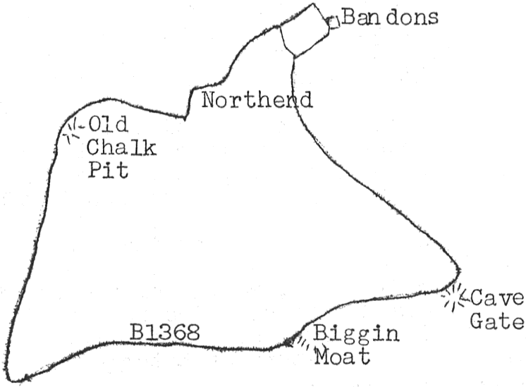
For those who have not yet read the Nuthampstead Zodiac publication, I will give a brief description of the Taurus figure outlined in it.
The figure is shown above and represents only the head of the bull, its snout being at Cave Gate, the forehead following the line of a road to Bandons, where the ear is formed by the roads leading to Bandons Farm. The back of the head then follows a winding minor road in a roughly north north west direction past {25} an old farm house and farm buildings at Northend to a crossroads and the site of an old chalk pit. The head is then cut off by a line running roughly west north west to a tee junction in Barkway. The underside of the neck then runs along the B1368 past Biggin Farm, the site of an ancient manor house and hospital, returning to the snout at Cave Gate.
My alternative figure is shown below.
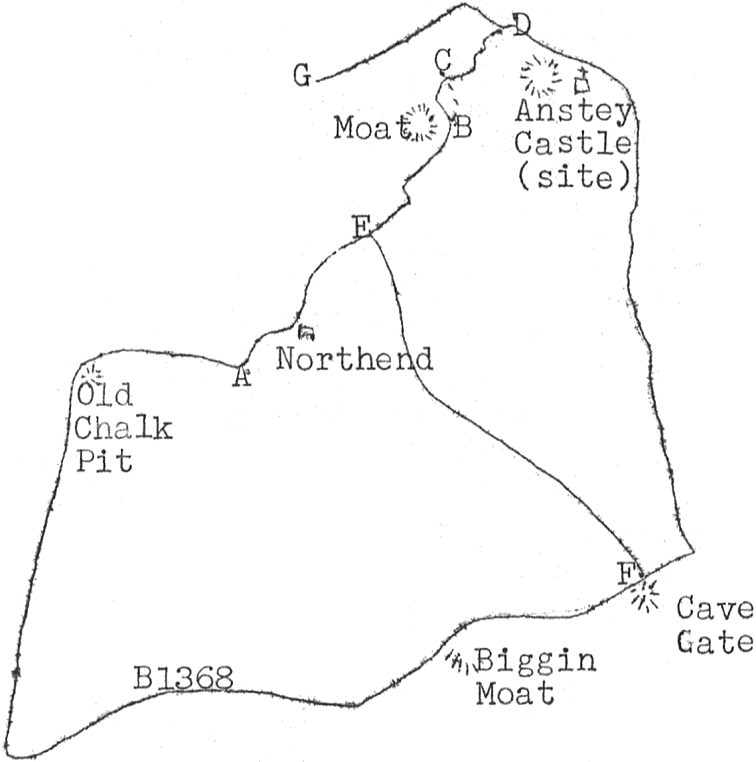
In my opinion it possibly represents a bison type bull. Once again starting at Cave Gate, this time a point just behind the foreleg, the baseline travels roughly north along the B1368 to the tee junction. The hind leg then runs approximately south south east to the tail at a crossroads, from whence roughly south until entering a series of bends near Northend farm. At this point, {26} marked ‘A’ on the diagram, the road runs below the level of the surrounding farmland, it continues to do so until point ‘D’ is reached. In between ‘B’ and ‘C’ the road is level with the surrounding land. I believe that the original figure was outlined by a ditch and that in places this has been converted into a road. This original ditch can still be seen some 50 yds to the south of the road at ‘B’–‘C’. It meets the road approximately at ‘C’, where there is a pond. At ‘D’ there was once a well which has been replaced by a standpipe. From here the top of the head runs through the village of Anstey to the church. Then on by way of a footpath to the B1368 and along this road returning to Cave Gate. There is a minor road ‘E’–‘F’ on the diagram, which I believe is also part of the figure, representing the diversion of the head and shoulders from the back and hind legs.
As I wrote earlier I believe that the original figure was cut and marked out by ditches, some of which have been converted into modern-day roads. This type of ‘sunken road’ can be found all over the zodiac and is a common feature of the countryside thereabouts. Therefore as a general rule, I should like to suggest SUNKEN ROAD = CONVERTED FROM DITCH = PART OF ZODIAC.
note: After following my theory in the field I have discovered a further stretch of sunken road marked ‘D’–‘G’ and I believe this may represent the horns.