Ancient Mysteries no. 16, July 1980 (continuation of Journal of Geomancy)
{40}
{41}
It was in Hereford in 1870 that William Henry Black put forward the theory that there was a definite, deliberate pattern to the shape of our counties, cities and parishes, that the whole countryside had been surveyed by an earlier sophisticated civilization, who had fixed boundaries and landmarks.
Fifty years later Herefordian Alfred Watkins read to the Woolhope Club his startling suggestion that ancient man had created straight tracks over many miles, making alignments that he called leys, linking several sacred sites such as burial mounds beacon-points, ponds, standing stones, homesteads and churches. Now, another sixty years on, I would like to offer a third theory about the geometrical patterns of Herefordshire. I call it the Patchwork Principle, for reasons that will become obvious.
What the Black theory, Watkins’s leys and the Patchwork Principle have in common is evidence that Herefordshire had remained a unit for thousands of years until the 1974 reorganization but that it was created at a time in prehistory when mankind was still supposed to be grubbing a miserable living with crude axes rather than being capable of the surveying needed to measure out the precise area of thousands of acres of land.
Here I want to put forward the Patchwork Principle, a new theory as yet undeveloped but, I feel, one that is at the stage of wanting discussion and comment. But before I describe it I will try to outline just what W.H. Black was suggesting over 110 years ago.
Black was an assistant keeper of records at the Public Record Office in London and was the official palaeographer and leading member of the British Archaeological Association. He was born around the turn of the eighteenth century and died in 1872. From a fairly early age – probably his early 20s – he had taken an interest in boundaries and in the apparent alignment of mounds and other prehistoric monuments. His first published work was a collaboration on part of a {42} history of Wiltshire in 1835 and he had spent many years on an edition of the Antonine Itinerary, the 3rd-century list of Roman roads that historians still use to identify Roman sites; whether he undertook this in an official capacity we don’t know, but it was to have been published by the Public Records Office. He died before it could be finished.
When he came to Hereford in 1870 he had been lecturing on the Romans and the use to which, he believed, they had put prehistoric landmarks like barrows and standing stones. For nearly 20 years he was a frequent speaker to the London and Middlesex Archaeological Society and to the Society of Antiquaries. So what was he doing in Hereford?
Fortunately the British Archaeological Association had chosen Hereford of all places to hold that year’s annual congress. These antiquarian groups, of which there were several in Victorian times, would usually choose a city well away from London, presumably to have a holiday as well as a congress. The existence of the Woolhope Naturalists’ Field Club doubtless boded well, and club members were instrumental in organizing the BAA congress in 1870.
It was a foregone conclusion that W.H. Black would speak at the congress, for he was by then an elder statesman of the Association; and Black obviously did his homework before he came. On the morning of September 6 he climbed the heights of Credenhill with members and guests and with extensive use of maps he explained his theory. That evening he gave his talk on Boundaries and Landmarks, using Herefordshire as an appropriate example.
Unfortunately it isn’t clear just what W.H. Black’s theories were. He had spent 50 years researching them but never got round to putting them down in print. His talks, some of which have come down to us, are not easy to follow.
In this paper, reported in the Journal of {43} of the BAA and in that week’s Hereford Times, he is typically abstruse. Without the maps he used to illustrate his points, we are lost. What we gather is that he had come to the conclusion that Roman surveyors, called agrimensores, laid out the boundaries of their provinces according to strict geometric principles, using ancient monuments as landmarks. In this last respect he uncannily predicted the researches of Alfred Watkins, who was 16 when Black came to his home town Hereford, and may well have read the theories in the Hereford Times or even been at the lecture.
It was, to say the least, a controversial paper. Some of his audience, in the politest possible way, all but called him a lunatic. They didn’t, of course, because they were Victorians and Gentlemen and W.H. Black had been boring them with his theories for many years. The meeting ended in good spirits with Black laughingly agreeing to differ with his critics. He was obviously used to such deprecation.
“Let me assure my fellow archaeologists that the ominous shake of the head, or toss of the nose, or grumble, growl or sneer, when I have attempted to reproduce the secret professional knowledge of the ancients, have never deterred me from prosecuting my researches or bringing them forward in public societies on every reasonable occasion” he warned.
What, then, was this “secret professional knowledge of the ancients”? What was W.H. Black doing up on Credenhill? What can we glean from that talk at the Green Dragon on the evening of September 6 1870, one of the very few of his papers that was reproduced in full?
“Monuments exist marking grand geometrical lines, lines which cover the whole of Europe, extending beyond Britain to Ireland, the Hebrides, the Shetlands, the Orkneys, right up to the Arctic Circle. These lines are all carried out on a principle which I have had the happiness of detecting” he told his audience.“Some of those great lines I had the pleasure of exhibiting upon Credenhill for explaining the {44} use made of that hill.
“In about the time of the Emperor Maximus Roman Britain was subdivided into a number of smaller provinces. This part of the country was made into one small province. It was requisite that there should be a central point of observation from which the lines of measure should pass to the adjoining provinces. That centre is Credenhill.
“But this system is more ancient than the Roman Empire and it goes far wider. It exists in India, China, in the provinces of the East, which are all laid out in the same way. … The ancients covered the land with monuments having a strict geometrical relationship with each other …”
It all sounds very unlikely and very confusing. No wonder his audience didn’t take him too seriously. In fact he made his case more succinctly the following year, again to the BAA, when he referred to his Credenhill visit. “I demonstrated to you that the boundaries of Herefordshire”, he said, “were fixed by means of the intersections of radial lines with parallels of latitude distant 5 degrees from each other and passing through a common centre, the Roman camp of engineers at Credenhill, until they reached natural or other artificial, but previously established, boundary lines and points.”
It is still far from clear what he meant. But he was saying that boundaries and prehistoric monuments are not arbitrarily sited but are geometrically organized, the exact mathematical nature of which is complicated.
Conventional historians will tell you that Herefordshire was created by Edward I out of the old former kingdom of the West Angles in the 11th century. Black’s theory was obviously revolutionary.
By 1870 Black was obviously so well versed in his own theories that he found it difficult to express them simply to laymen who had not heard them before. He must have felt he was {45} knocking his head against a brick wall, and the more he delved into the subject the more he became sure – but the less he was able to communicate the essence.
He knew about the work of the Rev. E. Duke, who had written about alignments in the Stonehenge–Avebury area in 1845, but Duke’s work was a mixture of mythology, astrology, Druidic nonsense and acute observation, expressed in prose even more difficult than Black’s. But within 30 years of Black’s Hereford talk, F.J. Bennett was writing on megaliths and alignments in Kent (available from IGR @ 40p) and Ludovic MacLellan Mann was doing research similar in many ways to Black’s in Scotland. Hadrian Allcroft, Sir Norman Lockyer and, of course, Alfred Watkins all had published work on alignments and landscape geometry within 50 years of Black’s revolutionary talk at the Green Dragon … but none of them, it appears, had even heard of this pioneer worker. Black’s work was rediscovered by Nigel Pennick of the IGR, who published a thin volume of his theories in 1976.
These days geomancy occupies researchers all over the world though with no more encouragement from conventional archaeologists than Black or Watkins received. What modern workers have found seems to confirm very much the basic ideas behind Black’s obscure theories. Ancient man seems to have surveyed the landscape with great precision and apparently with great stress on numerical relationships – that is, treating the actual distances involved as important parts of a great plan.
But back in 1870 Black was very much a loner. Today even traditional archaeologists accept prehistoric technologies such as the so-called Megalithic Yard measurements of amazing precision discovered in stone circles by Professor Alexander Thom or the equally astounding mathematical exactitude and complexity of Stonehenge or the evidence that mathematics, in the form of numerical notation and counting, was known 35,000 years ago. When Black was talking to the {46} archaeologists of the BAA in Hereford the only possible society of antiquity remotely considered capable of the sort of surveying he proposed would have been the Romans.
Roman geomants were called agrimensores, or gromatici, and to Black they were “an organized and corporate body; they were not merely men of special profession but men of authority”. We now know more about these agrimensores and see that they were not just super-surveyors but a group that were the inheritors of a secret knowledge. Nigel Pennick calls them both practical and religious with an organization comparable to that of the later Freemasons.
“Their training included tuition in cosmology, astronomy, geometry, orientation, sighting, levelling, land-law, boundary definition, allocation of land, mapping, scale drawing and recording”, says Pennick.
But was it a group of agrimensores that surveyed from Credenhill and drew the boundaries of the county that were to remain virtually unaltered until modern times? To the Victorian, the Romans were the only civilized race to inhabit Britain before the Norman conquest and it was natural that Black, despite his far-seeing and unconventional attitudes to antiquity, should assume the ancient surveyors to have been Roman rather than any possible earlier native British forerunners of the agrimensores, such as the Druids; by Victorian times the Druids had got a bit of a bashing as a reaction against the fantastic ideas about them that had been concocted in the 18th century, and it is only today that we can reappraise their prehistoric skills and rituals.
When Black spoke in Hereford he believed Credenhill to be a Roman camp linked to the city of Magnis or Magna, found at Kentchester at the bottom of the hill and first excavated back in the 18th century. What recent investigations have shown is that Credenhill is much {47} older than the Roman occupation – and what Black couldn’t have known because it was only proved by archaeological excavation a century after he had climbed the hill that September morning, is that his central sighting point for surveying, Credenhill, was “the ancient capital of a very large area …”
The Romans built Magna in the second century AD. Credenhill had been a prehistoric centre for perhaps thousands of years before then. It is officially put in the Iron Age, which started around 600 BC, but this dating is based on actual finds. Its significance could date back to megalithic times. Its importance, we now know too, is not just in its age but in its size: it covers 50 acres, while most hill-forts in Britain are less than 15 acres. Clearly Credenhill was a major prehistoric site, something implied by Black and now confirmed by archaeologists.
“Four acres larger than Maiden Castle” (Britain’s most famous hillfort) “it becomes the largest hillfort in Britain on which such a lengthy permanent occupation has been demonstrated”, declares Professor S.C. Stanford of Birmingham University, who spent years delving into Credenhill’s ancient secrets after excavating many other hillforts.
“Twice as large as any other hillfort in Herefordshire, it must be regarded as the pre-Roman capital of this part of the border”, he concludes. Prof. Stanford’s findings published in the past few years and confounding the suppositions of archaeologists up to that time, confirm utterly W.H. Black’s insistence that Credenhill was the centre of the county. We now come to the Patchwork Principle.
Herefordshire in outline is a roughly circular shape with a flattened west side, where the Black Mountains form a natural frontier with Wales. The Monnow and Wye roughly form the southern boundary, the Malverns the eastern, while the Teme describes the northeast and northern parts. Historians tell us, {48} as I have mentioned, that the county was carved out of the old kingdom of the West Angles, which also included Shropshire, by Edward I in the early 10th century. The Domesday survey, over a century later, confirmed the county boundaries, with odd detached pieces of Herefordshire as enclaves in the surrounding counties. Local Government Acts in the 19th century readjusted parts, with a general tidy-up in 1931. In 1974 the county boundaries all over Britain were redrawn and Herefordshire disappeared, losing its eastern boundary and becoming incorporated into the administrative nonsensity of Hereford-Worcester.
Reliable maps, showing precise boundaries, were not available until the Ordnance Survey started work around 1800; the whole country was not finally surveyed until 1870 – the year Black spoke in Hereford! (The Hereford map appeared in 1831.) 16th century maps of Herefordshire, for instance, are terribly inaccurate and no guide to the exact line of the boundary. Until the OS the course of boundary was defined by oral and written tradition by ‘perambulations’ where the landmarks were described. Later, even when the landmarks had disappeared or their significance had been lost, the custom of ‘beating the bounds’ helped preserve the crucial points on local boundaries. The boundary points, in parishes, towns and counties, have always seemed to have a special significance and can be seen to have remained constant over the centuries not because of lines drawn on maps but because of sustained and repeated traditions.
Herefordshire is, – or was before 1974 – surrounded by 6 counties: Radnorshire, Shropshire, Worcestershire, Gloucestershire, Monmouthshire, and Brecknockshire. There are, therefore, six junctions around the perimeter of the county where three counties meet.
I took the outline of modern Herefordshire and marked these junctions. They are roughly in the north-west, north-east, east, south-east, {49} south-west and west. When we come to superimpose the outlines of Herefordshire before any tinkering with the boundaries we see that only one of these boundary points appears to have been changed, despite the illogical situation of several of these junctions.
Black suggested that the boundary junctions were planned by radials from the centre at Credenhill, so I drew a line from the north-west point to the south-east, roughly cutting the county in half. Credenhill lay precisely on the line, around mid-way between the points. So far, so good.
I drew a line from Credenhill to the other points. To the west the two lines were exactly the same length – 13.6 miles. To the east 3 lines were around the same length, with a maximum variation of 1.5 miles: 18.5 miles, 19.6 miles and 20 miles. Near enough to give me a shock, though I was worried about the fourth point, which was 16.5 miles, where Hereford met Shropshire and Worcestershire.
I then superimposed a map of Herefordshire of pre-1931 which showed those odd detached bits of the county that were separated from the bulk, little islands of Herefordshire in Radnorshire, Brecknockshire and Worcestershire. I marked the furthermost point in these detached parts. Cascob in Radnorshire was 18.8 miles from Credenhill. Pont Newydd, at the corner of Fyddog in Monmouthshire, was 18.8 miles. Rochford in Worcestershire was 18.6 miles. What’s more I had solved the problem of the errant north-east junction: the boundary used to be the Teme between Ludlow and Whitbourn – and the old boundary junction was Rochford.
I now had 2 radials of 13.6 miles and 4 measuring 18.5, 18.6, 19.6 and 20 miles and another 2 lines from Credenhill of 18.8 miles to what could have been former boundary junctions. The variation between 18.5 and 20 miles can be accounted for, surely, by either the {50} physical difficulty of measuring land over that distance or by a slight change in the exact position of the boundary point.
Finally, I discovered more symmetry. There were six angles between the spokes of the wheel that had Credenhill as its axis. There are two sets of equal angles on each side of that long north-west line to the south.
Who, then, was responsible for this planning exercise? The Roman Agrimensores that Black suggested, men who we now know were highly skilled and used measurements as did masons and geomants, as sacred shorthand for the laws of the Cosmos? Probably not, for the Agrimensores were only one school in an ancient tradition of geomancy. Nigel Pennick writes, “boundaries were believed to express a divine division of the world, vital components in the preservation of cosmic order against primeval chaos.” Thus, he says, the rituals regarding the inviolability of boundaries and the reverence afforded to boundary stones, mark-trees and so on; thus, too, the apparent illogicality of the shape of boundaries. The geomants of which Nigel Pennick writes, whose role was linked with the matter of boundaries, were still active in the middle ages but they were also active long before the Romans; their craft is rooted in an ancient wisdom lost in prehistory.
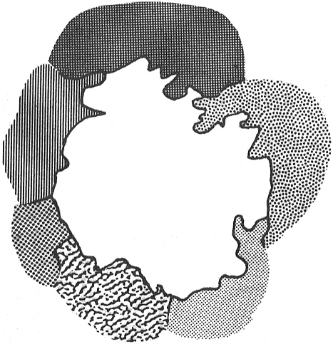
But let’s leave aside the actual sacred significance of the boundary points and of the measures used and simply accept that the land was laid out to a definite plan. The Patchwork Principle suggests that Herefordshire was designed – consciously, geometrically, designed – from an established central surveying station and that radials were extended. Between each boundary point, a vertex of a huge hexagon, natural features such as rivers and hilltop ridges formed the actual frontiers. Each boundary point is a vertex of three polygons and the design problem, the actual {53} creation of the patchwork over the whole land, is inconceivably enormous, as anyone who has tried to make a quilt from patchwork polygons of varying sizes and shapes knows.
It seems impossible. But what other explanation is there? Perhaps there are just some counties like Herefordshire geometrically designed, with others no more than shapeless, asymmetrical make-weights? Perhaps Herefordshire is an isolated example, a unique piece of precise landscape geometry? Looking briefly at Shropshire, Worcestershire and Monmouthshire, I can see possible patterns; Gloucestershire was originally several units and in its present form is a relatively recent creation, but the Forest of Dean seems to have its own geometric logic with Speech House at the centre of its polygon*.
* The miners of the Forest of Dean, like those of Cornwall, had their own parliament – ED
Obviously we need to examine every county, find a central point and draw our polygons. One little change in the boundary points such as that in north-east Herefordshire not only distorts that county’s geometric pattern but that of the other two adjoining counties as well. We’re lucky with Herefordshire: not only have there been few boundary changes over the centuries but we had William Henry Black to point the way with that talk in the city in 1870.
Black was convinced that the Romans were responsible; all Victorians thought that civilisation started with the Romans. With our information on Credenhill and on the widespread examples of prehistoric geomantic engineering all over the world we can confidently look further back in prehistory.
For the Patchwork Principle illustrates that boundaries did not evolve over a period of time, the result of territorial give-and-take, but were geometrically designed at some specific point in time and were preserved ever since. It illustrates, too, that what we {54} think of as an invention of the twelfth century, the county, is in reality a territory established on quite different lines long before.
And if Herefordshire was meticulously planned, surveyed and laid out according to some sacred design that we can only guess at, at a period in time when mankind was supposed to be thin on the ground, obsessed with basic survival, clad in animal skin and woad, and laboriously working with crude tools and communicating only by grunts, what then? Silbury hill, Avebury and Stonehenge were apparently built by the same sort of prehistoric man.
Is it just the arrogance of modern man that makes him think that his forebears were less capable than he? If the boundaries of Herefordshire were laid out for the same reasons as the better-known examples of prehistoric landscape engineering, then there was a supreme sacred purpose behind the shape of our county. It took twentieth-century bureaucrats to dismantle the geomantic symmetry of Herefordshire. Modern man has triumphed.
The Patchwork Principle is a very interesting concept. Perhaps ANCIENT MYSTERIES readers might like to test it on their
own counties. We await any results.
THE EDITOR