Prepared by Pat Gadsby and Chris Hutton Squire of the Undercurrents Alternative Science Research Unit.
‘All that can be learn’d of them is, That Here they are.’
Daniel Defoe, Itinerary
It’s quite easy to make a computer hunt after leys and to check their accuracy of their alignments. Pat Gadsby and Chris Hutton-Squire have been working in this area for some time. They describe what they’ve been doing and report on their preliminary findings.
‘There are nine and sixty ways of constructing tribal lays,
And every single one of them is right’
Rudyard Kipling (In Neolithic Times)
In 1925 the Herefordshire antiquarian Alfred Watkins put forward the hypothesis that the ancient sites of pre-Roman Britain were deliberately aligned with one another. In his book describing the hypothesis, The Old Straight Track (Garnstone 1970) he christened these alignments ‘leys’. In the fifty years since then his theory has never been scientifically tested, though many ‘ley hunters’ have succeeded in establishing to their own satisfaction, if to no-one else’s, the reality of the ley system. There were three reasons for this omission:
i) Orthodox scientists and archaeologists saw no reason to investigate phenomena they ‘knew’ to be imaginary
ii) There was a shortage of reliable evidence
iii) Before the advent of the computer, there was a natural reluctance to undertake the backbreaking task of tabulating the many thousand possible alignments between a set of sites and calculating the ‘best fit’ straight lines through them. For example, one hundred sites – a modest number in practice – would generate 161,700 triads (sets of three points) and 3,921,225 tetrads (four points). Such is the awful power of the laws of combination and permutation.
The lack of reliable data was made good by John Michell in 1974 when he published a description of the alignments that he had found between the fifty plus surviving standing stones of the Land’s End peninsula in Cornwall (The Old Stones of Land’s End, Garnstone). These stones, although some of them are twelve feet high, are small well-defined sites compared with those used by earlier less critical ley-hunters. Nevertheless, Michell claims that they are aligned over distances of up to ten kilometres to ‘rifle barrel’ accuracy. This display is the first independent test of his claim.
This study is the first research undertaken by the Undercurrents Alternative Science Research Unit, an offshoot of Undercurrents Ltd (213 Archway Road, London N6), publishers of Undercurrents, the magazine of radical science and technology. Although the study and it is not yet complete, we feel that the results obtained so far are sufficiently definite and interesting to justify setting them before the public at this time.
1. To check the accuracy of the 22 alignments between the 53 sites described by John Michell in The Old Stones of Land’s End
2. To tabulate all of the other alignments between these sites.
3. To tabulate the alignments between a similar set of randomly placed sites.
1. To attempt to describe the programs used in the computer runs would take a great deal more space than is available here. It is sufficient to state that they work and that further details can be obtained by anyone who is interested.
2. The computer was used to calculate the best fitting straight line through each of the 23,426 possible triads (set of three points) by the standard statistical method of linear regression. This method minimises the sum of the squares of the displacements of the points from the line.
3. The triads that matched our standards of accuracy were tabulated. The two standards that were applied were:
i) width needed to cover all three points to be less than 10 metres
ii) ratio of width to length to be less than 1:100Clearly a misprint for 1000 (i.e. 1 metre per kilometre)
4. It is important to note that these standards are arbitrary; in fact they derive from a study of the preliminary runs we did. There is no theory of leys that says how narrow they should be. Some dowsers that we have spoken to consider that leys are no more than two metres wide.
5. Best fitting straight lines were calculated by the same method for potential high-order alignments that the first run had revealed.
6. The same exercise was carried out on the simulated data.
1. In The Old Stones of Land’s End John Michell lists 53 sites comprising:
4 stone circles
5 quoits (i.e. three or more stones piled on each other)
7 crosses
36 standing stones
and 1 holed stone (‘Men an Tol’)
2. The National Grid references of 45 of these sites were re-estimated to ten figures (i.e. to the nearest metre) using 6 inch Ordnance Survey maps and a plan-digitiser.
3. The remaining stones were discovered by John Michell during his field-work and are not marked on the Ordnance Survey maps. He has accurately surveyed the location of four of these but only estimated the location of the others.
4. The ten figure grid references of the seven most important stones in the Boscawen-un Circle were taken from the 1:2500 (25 inch: 1 mile) Ordnance Survey plan of the area.
5. The Ordnance Survey states that positions taken from these maps are subject to statistical uncertainty inherent in the mapping process. The average error is not more than 3.5 metres but our results suggest that the positions taken are accurate to 1 metre.
6. Random number tables were used to generate a set of imaginary references for the 53 points. Only the final three figures of each reference were changed, so that the imaginary points each lie in the same kilometre square of the National Grid as their real counterparts. This ensured that while the deliberate alignment (if any) of the real points was destroyed in the simulation data, their distinctly non-random clustering was not.
1. John Michell lists 22 alignments between the 53 sites. We found that 20 of these alignments match our standards. The two that failed are both aligned on site 28 (the Merry Maidens stone circle). One alignment is 12 metres wide and the other is 2 metres wide but only 1 kilometre long. Both are probably aligned on the circumference of the circle rather than its centre, but we have not yet been able to test this.
The average width of the 20 lines is 1 metre, the maximum width is 7 metres and 7 alignments are exact fits (to the nearest metre).
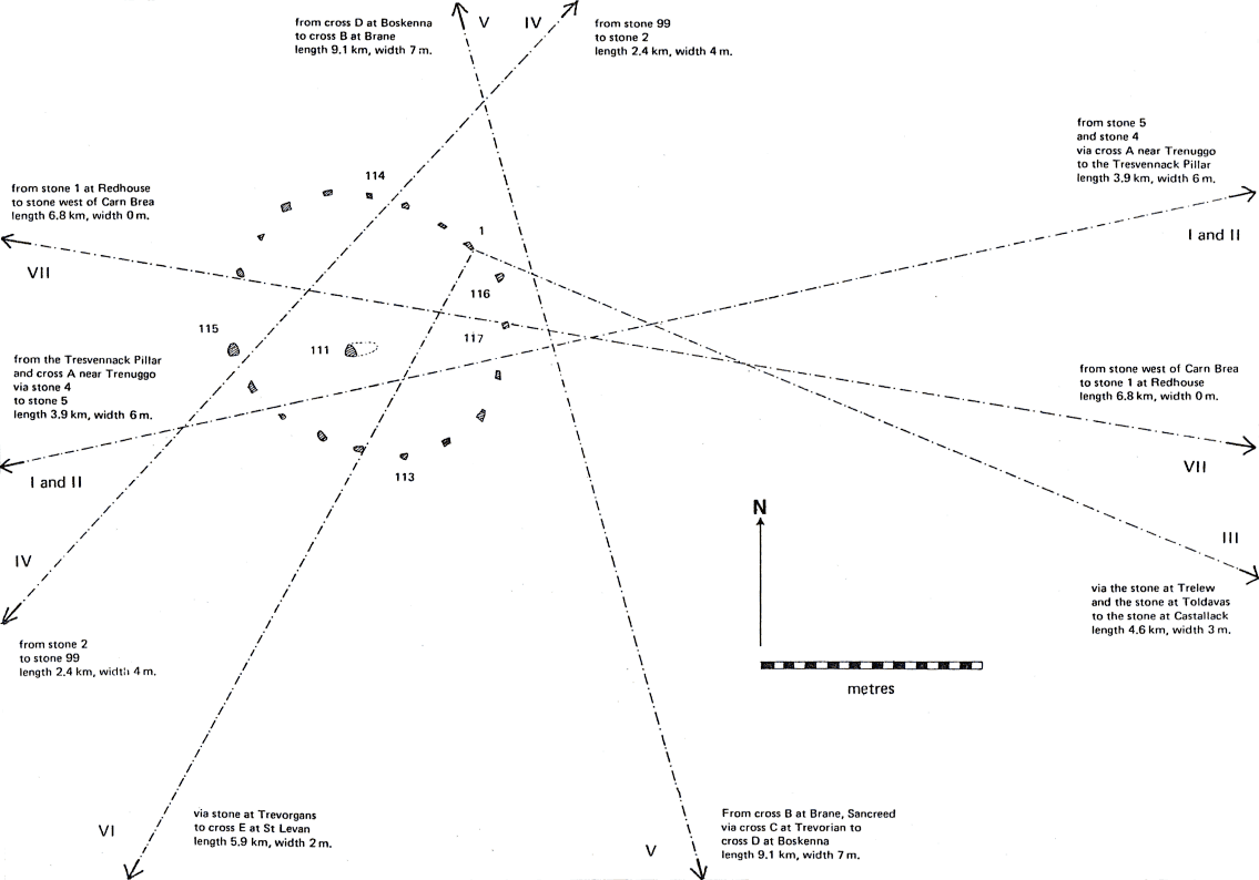
2. John Michell gives 7 alignments on the stones of Boscawen-un-Circle. We have confirmed all of these (see the accompanying plan and table. Note that we regard Line I and II as forming a single five-point line, while John Michell considers that they are distinct.
3. Allowing a maximum width of 20 metres, we found only one five-point
alignment, the one mentioned above. We confirmed the three four-point alignments
claimed by John Michell
sites 1 – 6 – 7 – 8 (width 3m, length 4.6 km)
46Cross B
–
116 –
47Cross C
–
48Cross D
(width 7m, length 4.8 km)
and 4 – 9 – 16 – 17 (width 2m, length 8.7 km)
and we found two more:
sites 2 – 12 – 16 – 17 (width 14m, length 6.7 km)
(this is close to, but distinct from, the previous line; it is in fact an
extension of a triad (2 – 12 – 16) listed by John Michell)
and 7 – 14 – 18 –
99Stone at 39782594, mentioned but not numbered by Michell (p. 20)
(width 6m, length 4.9 km)
(this is a completely new alignment)
These five lines are shown on the map.
4. We found 29 new triads making a total of 51. The full list is given on the computer printoutThis was not published. headed ‘analysis’.
5. We found that site 17 (‘A stone in the hedge at Sennen’) also has
7 alignments running through it. This stone stands near Land’s End itself, opposite the
First and Last Inn. In addition to the three alignments listed by John Michell:
4 – 9 – 16 – 17
20 – 18 – 17
and 42 – 36 – 17
we found:
2 – 12 – 16 – 17 (already mentioned)
and three new triads:
6 – 15 – 11
50 – 27 – 17
and 26 – 19 – 17
The average width of these 7 lines is 4 metres.
The simulated site 17 has only one line through it, so this appears to be good evidence of deliberate alignment.
6. The simulated data yielded one tetrad and only 34 triads (i.e. two-thirds of the yield from the real data).
7. On average, each real site lies on three lines; each simulated site on only two.
8. The sites that score an above average number of lines on the real data, score below average on the simulated run (e.g. site 17 already mentioned). And vice versa: the bottom 9 real sites lie on only 7 lines between them; the same 9 simulated sites lie on 28 lines. This appears to be evidence of the deliberate non-alignment of these low-scoring sites.
9. The average width of the 20 alignments of John Michell is 1 metre: that of the new triads between the real sites is 4 metres. The combined average (3 metres) is the same as that of the triads between the simulated sites.
1. Robert Forrest has shown (The Linear Dream, p. 3) It is easy to show that if the sites are scattered at random over the map, then the number of alignments with three, four, five etc. sites on them will (approximately) follow a Poisson distribution with parameter k, where k is the expected number of sites on a line drawn between any two sites and (roughly) the probability that any line will have one or more sites on it. The Poisson analysis must be used cautiously in this case as it is clear that the sites are not scattered at random, but it does cast as no experiments have been done so far to see how well it fits results calculated from an actual set of random points. It does, however, have the merit of being familiar and easy to calculate.
There is an added reason for caution in this case: it is obvious to inspection, and easy to prove statistically, that the points are not scattered at random but clustered into two groups. Nevertheless the analysis casts an interesting light on the results we have got.
2. The formula for k is:
k = Nxy/A
where
N is the number of sites (53)
x is the width allowed (10 metres)
y is the average length (6.5 km for the simulation)
and A is the area of map (140 km2).
These values give a result for k of 0.025.
3. This means that, on average, only one line in forty will have a third site on it. The number of possible lines between points is 1,378. So we would expect about 34 triads from the simulated data. The actual score is 36.
4. Similarly we can calculate that the expected number of tetrads is only 0.4 (i.e. we would expect to get four tetrads from every ten simulation runs carried out). The score from this run was one tetrad.
5. The results of the run using the real sites (1 pentad, 5 tetrads and 51 triads) are well above chance. Unfortunately we cannot put a figure on the odds against this result occurring by chance alone (what statisticians call the significance level) as we do not know the actual probability distribution of alignment numbers. What we can say is that the expected number of pentads, according to the Poisson formula, is only 0.004. This means, roughly, that we would expect to get one pentad by chance from 250 runs. The odds against getting 51 triads are about 160 to 1.
The question we must ask is: Are these results sufficient to justify us rejecting what statisticians call the Null Hypothesis (i.e. the hypothesis that the stones are clustered but not aligned), so that the alignments are no more than chance effects?
This question is usually answered by calculating the odds against the observed result being the work of chance alone and rejecting the null hypothesis if these odds are higher than some conventional figure, 20 to 1 or 100 to 1. This straightforward approach is not open to us as it is apparent, and quite easy to prove statistically, that the sites are not randomly distributed but are clustered together in particular areas. This means that the only way that we can discover the odds against a set of sites aligning by chance is by doing a series of simulation experiments similar to the one described here.
What we can say is that these results are sufficiently striking to justify further research.
The first task if to re-survey the sites. We are investigating the possibility of using sophisticated electronic measuring equipment to obtain positions accurate to the nearest foot (i.e. three times as good as those we have now). Looking further ahead, a multi-disciplinary programme of research has been drawn up. It combines the skills and talents of a statistician, a computer scientist, a geologist, a surveyor and an expert in ultrasonics. Additionally, in view of the success of dowsers in establishing the path of alignments, a parallel investigation will be undertaken this summer by a team from America led by a white magician and mind-control expert. This team will include a leading English dowser. It will be interesting to compare their results with ours.
P.G.
C.J.L.H.S.
Postal address was here.
Spring Equinox 1976.
The most promising line of attack on these results for any sceptic is to argue that the set of sites used was selected post hoc by John Michell from the much larger set of possible sites and that sites which didn’t align were deliberately not listed. It is to this problem we now turn. John Michell has told us that he found these sites by a combination of study of the 6″ maps of the area and fieldwork. His list is certainly not exhaustive nor was it determined by some a priori objective criteria.
We are fortunate that Land’s End is one of the very few areas of Britain for which an exhaustive and objective gazetteer of ancient sites has been published. The West Penwith Survey by Vivien Russell (Cornish Archaeological Society, c/o Royal Institution of Cornwall, Truro) was being prepared while Michell was working on The Old Stones of Land’s End and was in fact published just before it. It lists a further sixty-odd sites, mostly crosses, that there is no a priori reason to omit. So our next task is to tabulate all the alignments between this enlarged set of sites. This presents a problem as the time required for the tabulation goes as the cube of the number of sites, i.e. it is increased eightfold to about 20 hours on our present system (plus another twenty for a simulation run). So it may be a while before we get it done.
We also intend to do some studies of random sets of data to see how good a fit we get to the Poisson formula. This problem has excited some controversy among mathematical leyhunters which we hope to resolve. It remains our opinion, however, that the correct way to evaluate the significance of a set of alignments is to compare them with the results of a simulation as we have done and not with a formula which must always be only approximately valid. The usefulness of the Poisson formula is that it provides a quick estimate of what is to be expected in a particular case. The result is often quite chastening: it is surprising how unsurprising some of the ‘surprising’ results that leyhunters have found actually are.
This report was first produced for an exhibition which was held at the Institute of Contemporary Arts during April 1976, and it was subsequently published in The Ley Hunter. The response from the ley hunters has been very disappointing. We had hoped that we would be offered other groups of data for analysis, but, so far, no-one has approached us. The set of programs is a dual-purpose tool – it can examine relatively large numbers of potential ley-markers and then list the triads which are worth further investigation; or, it can be used to evaluate leys that have already been found. We would appreciate some response from the outside world, so get in touch with us – please!
This plan shows how the six alignments that converge on Boscawen-un-Circle are aligned onto individual stones of the circle. The Roman numerals are those used by John Michell. The stone numbers refer to the computer listing. The plan is derived from the survey made by Professor Thom. Note that we regard lines I and II as forming a single five-point line, while John Michell considers that they are distinct.
The following descriptions are taken from the Old Stones of Land’s End by John Michell (Garnstone Press, 1974).
I. Boscawen-un Circle — stretch of old walled track towards Boscawen-un Farm — Cross A — Stone 3 — Church of St Piran, Perranuthnoe. This is an extension of Lockyer’s line 5.
II. Stretch of walled track — Boscawen-un Circle — Stone 4 — Stone 5. This line deviates by no more than one degree from alignment I. From the Circle Stone 4 stands out on the skyline, and when this stone is approached from the direction of the circle, Stone 5 appears in view behind it. These two stones are placed like surveyor’s rods, one on the near and one on the far side of a ridge as seen from the Circle.
III. Boscawen-un Circle — fallen stone at 41822707 — Stone 6 — fallen stone [?] at 42432682 — Stone 7 — Stone 8. Lockyer’s line 6 in his astronomical survey of Boscawen-un is drawn from the Circle to Stone 6, marking the November sunrise, In fact Stone 6 could never have been visible from the Circle, but on the same line, nearer the Circle and at the point of extreme visibility from it, a tall pillar lies recumbent and half buried a few yards from Stone II. This fallen stone must have been the original November sunrise marker. Following the line eastward, a large erect boulder, Stone 7, was found at Toldavas Farm, and another, indented with cup marks and also previously unrecorded, at Castallack (Stone 8). Stones 6 and 7 are not intervisible, and there was probably once a stone between them, visible from both. This would have been where a cattle trough rests on what may be the fragments of a fallen longstone. Thus between the Circle and the sea at Pezner Point are three standing and one, possibly two, fallen stones paced on one straight line.
IV. Stone 2 — Boscawen-un Circle - Stone marked on 6-inch O.S. map at 39782594.
V. Centre of disc barrow at Botrea, 40313133 — ‘courtyard house’, 40423076 — Cross B — Boscawen-un Circle — Cross C — Cross D.
VI. Boscawen-un Circle — Stone 18 —Cross E.
VII. Stone 19— Boscawen-un Circle - Stone 20 — approximate site of lost stone at 45592648 — St Clement’s Isle:
The survey by Sir Norman Lockyer referred to is in Chapter XLII of his classic work, Stonehenge And Other British Stone Monuments Astronomically considered (London 1909).
Our thanks are due to:
Vivien Russell, whose excellent field work among the ancient sites of the
Land’s End peninsula (published as West Penwith Survey) was the foundation
on which this study has been built.
Robert Forrest of Bury, Lancashire, whose unpublished essay The Linear Dream
provided the stimulus for this work.
Galdor Computer Centre of Surbiton, Surrey, whose generous gift of free computer
time made it possible.
John Michell for friendly criticism.
John Cox of the ICA for the two maps.
Martyn Partridge of Undercurrents for the plan of Boscawen-un
stone circle and for help with layout and design.