
{28}
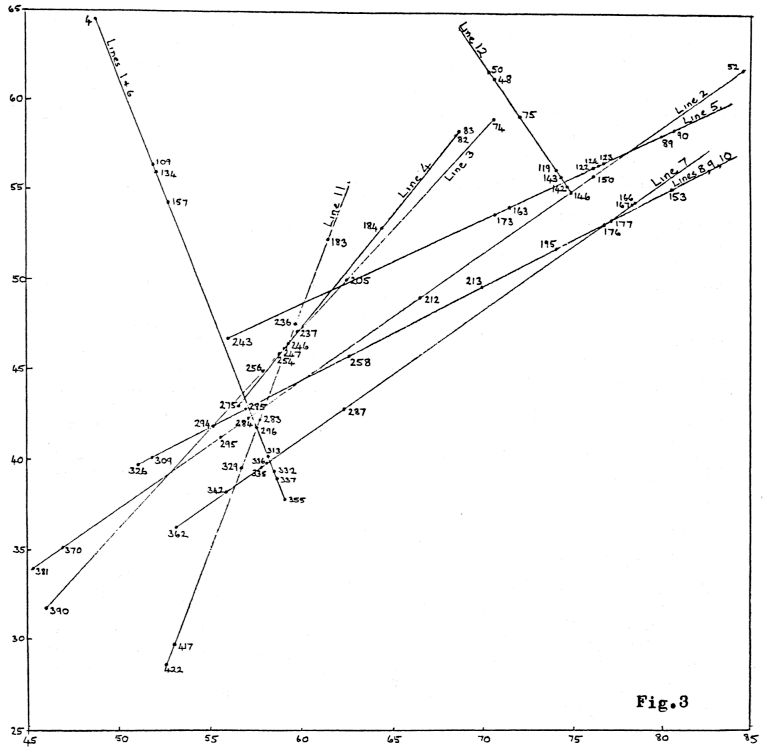
Each of the 12 lines in Fig. 3 is shown schematically with its potentially valid ley markers (its “kernel”) indicated by arrows. These are what we call the line profiles for Coldrum 2. For comparison, the profile of the actual Coldrum line would look like this:
The sites not indicated by arrows are post-reformation churches.
For each of lines 1 to 12, notes are given on the various sites involved. For notes on “potentially acceptable” ley markers see Appendix 1.4 and Appendix 9.2.
The sites alined in a simulation have, of course, fallen into line only after random nudging by the computer. The “original grid ref.” column gives the original position on Sheet 188. For grid references of the simulated sites after nudging, see Appendix 6a.
When the width of the kernel of the Coldrum line is calculated from the grid references of the site centres obtained from 1:2500 plans (sites 1, 2, 5 and 6 in Table 1) it is found to be only 13 m. Clearly the 50 m upper limit on ley width suggested by the 1 mm diameter of the map symbols on Sheet 188 is now no longer appropriate. However, one can argue that considered as an alinement on the ground the line of best fit could be allowed to pass through any part of each of the sites involved, so on the basis of site size (as opposed to 1:50000 map symbol size) a ley width somewhat larger than 13 m would be permissible. We estimate a ley width of up to about 20 m on the basis of actual site size. Consequently, in our line profiles, we would reject an alinement as failing to match Coldrum if its kernel had a width of more than 20 m; we would regard a kernel of width between 13 m and 20 m as satisfactorily matching Coldrum; and a kernel of width less than 13 m as definitely beating Coldrum.
In addition to quoting the width of the kernel of each of the 12 lines in Fig. 3, we also quote the kernel length. These are to be compared with the kernel length of the Coldrum line, which is 7.2 km. Line length and line width denote the length and width of the initial alinement, before its modern sites are removed. (These figures are obtained from Appendix 6b.)
{29}

Note. This ‘alignment’ is actually two distinct alignments,
if one sticks rigidly to the computer’s adopted ley width of 50 m on the ground.
The two lines are:
| Line. | Sites involved | Length. | Width. |
|---|---|---|---|
| 1 | 4–109–157–296–313–332–337–355 | 28.8 km | 48 m |
| 6 | 109–134–157–296–313–332–337–355 | 19.9 km | 29 m |
The two lines are so close to being the same, however, that a ley hunter would probably merge them into one 9-pointer in practice.
Site details.
| Site No. |
Type. | Original grid ref. |
Comments. |
|---|---|---|---|
| 4 |  | 482642 | Ch. at Chelsfield. Prob. post-ref. |
| 109 |  | 515561 | Ch. NW of Sevenoaks. Prob. post-ref. |
| 134 | | 526551 | Ch. in Sevenoaks. Prob. post-ref. |
| 157 | | 526549 | Ch. in Sevenoaks. Prob. post-ref. |
| 296 | | 578419 | Ch. at Southborough. Prob. post-ref. |
| 313 | | 581404 | Ch. at Tunbridge Wells. Prob. post-ref. |
| 332 | | 583398 | Ch. at Tunbridge Wells. Prob. post-ref. |
| 337 |  | 584390 | Ch. at Tunbridge Wells. Prob. post-ref. |
| 355 | | 592377 | Ch. SE of Tunbridge Wells. Prob. post-ref. |

| Line length | = 48.3 km | ; | Line width | = 26 m. |
| Kernel length | = 48.3 km | ; | Kernel width | = 21 m. |
Site details.
| Site No. |
Type. | Original grid ref. |
Comments. |
|---|---|---|---|
| 381 | | 450339 | Ch. at Coleman’s Hatch – prob. post-ref. but see Appendix 9, note 3 |
| 370 | | 480357 | St. Mary’s Ch., Hartfield. Pre-ref. |
| 295 | | 553414 | St. Mary the Virgin, Speldhurst. Pre-ref. |
| 284 | | 580427 | Ch. at Southborough. Prob. post-ref. |
| 212 | | 664492 | Ch. to NW of East Peckham. Prob. post-ref. |
| 146 | | 752553 | Ch. at Maidstone. Prob. post-ref. |
| 150 | | 760554 | All Saints Ch., Maidstone. Pre-ref. |
| 52 | | 847617 | St. Mary Magdalene, Stockbury. Pre-ref. |

| Line length | = 36.8 km | ; | Line width | = 46 m. |
| Kernel length | = 24.8 km | ; | Kernel width | = 31 m. |
Site details.
| Site No. |
Type. | Original grid ref. |
Comments. |
|---|---|---|---|
| 390 | Tum. | 467312 | |
| 294 | | 552417 | Ch. at Speldhurst. Prob. post-ref. |
| 256 | | 588456 | Ch. at Tonbridge. Prob. post-ref. |
| 254 | | 584459 | Ch. at Tonbridge. Prob. post-ref. |
| 247 | | 593466 | Ch. at Tonbridge. Prob. post-ref. |
| 246 | | 591468 | SS. Peter and Paul’s, Tonbridge. Pre-ref. |
| 205 | Moat | 626508 | Moat NW of Hadlow. |
| 74 | | 704592 | Ch. between Larkfield & New Hythe. Prob. post-ref. |
{30}

| Line length | = 19.4 km | ; | Line width | = 42 m. |
| Kernel length | = 19.4 km | ; | Kernel width | = 42 m. |
Site details.
| Site No. |
Type. | Original grid ref. |
Comments. |
|---|---|---|---|
| 275 | | 565432 | St. Laurence’s, Bidborough. Pre-ref. |
| 254 | | 584459 | Ch. at Tonbridge. Prob. post-ref. |
| 247 | | 593466 | Ch. at Tonbridge. Prob. post-ref. |
| 246 | | 591468 | SS. Peter & Paul’s, Tonbridge. Pre-ref. |
| 237 | | 590471 | Ch. at Tonbridge. Prob. post-ref. |
| 184 | | 644526 | St. Dunstan’s Ch., W. Peckham. Pre-ref. |
| 82 | | 689589 | SS. Peter & Paul’s, Leybourne. Pre-ref. |
| 83 | Castle | 688588 | Leybourne Castle. 14th century. |

| Line length | = 27.3 km | ; | Line width | = 41 m. |
| Kernel length | = 27.3 km | ; | Kernel width | = 29 m. |
Site details.
| Site No. |
Type. | Original grid ref. |
Comments. |
|---|---|---|---|
| 243 | Moat | 555466 | Moat at Leigh |
| 173 | | 705535 | SS. Peter & Paul’s, Teston. Pre-ref. |
| 163 | | 720542 | St. Margaret’s, E. Barming. Pre-ref. |
| 122 | | 764570 | Ch. at Maidstone. Prob. post-ref. |
| 124 | | 760562 | Ch. at Maidstone. Prob. post-ref. |
| 123 | | 765565 | Ch. at Maidstone. Prob. post-ref. |
| 89 | | 792582 | St. Martin’s Ch., Detling. Pre-ref. |
| 90 | Castle | 808582 | Thurnham Castle. Motte & Bailey. |

| Line length | = 31.2 km | ; | Line width | = 40 m. |
| Kernel length | = 27.6 km | ; | Kernel width | = 23 m. |
Site details.
| Site No. |
Type. | Original grid ref. |
Comments. |
|---|---|---|---|
| 362 | | 531368 | Ch. at Groombridge. Prob. post-ref. |
| 342 | Fort | 564381 | Fort at Ramslye. |
| 335 | | 583395 | Ch. at Tunbridge Wells. Prob. post-ref. |
| 336 | | 587393 | Ch. at Tunbridge Wells. Prob. post-ref. |
| 287 | | 626430 | St. Peter’s, Pembury (N. of village.) Pre-ref. |
| 176 | | 769536 | Ch. W. of Shepway (S. M’stone.) Prob. post-ref. |
| 177 | | 778535 | Ch. at Shepway (S. M’stone.) Prob. post-ref. |
| 167 | | 789541 | St. Nicholas, Otham. (N. of village.) Pre-ref. |
| 166 | | 784543 | Ch. at Mote Park (SE M’stone.) Prob. post-ref. |
{31}

Note. This ‘alignment’ is actually three distinct alignments,
if one sticks rigidly to the computer’s adopted ley width of 50 m on the ground.
The three lines are:
| Line. | Sites involved | Length. | Width. |
|---|---|---|---|
| 8 | 153–176–177–195–213–258–285–309 | 32.4 km | 43 m |
| 9 | 153–176–177–195–213–258–294–326 | 33.1 km | 46 m |
| 10 | 153–176–177–195–213–258–285–326 | 33.1 km | 47 m |
The three lines are so close to being the same, however, that a ley hunter would probably merge them into one 10-pointer in practice.
| Kernel length | = 33.2 km | ; | Kernel width | = 20 m. |
Site details.
| Site No. |
Type. | Original grid ref. |
Comments. |
|---|---|---|---|
| 326 | | 512391 | St. Martin’s Ch., Ashurst. Pre-ref. |
| 309 | | 525403 | Ch. at Fordcombe. Prob. post-ref. |
| 294 | | 552417 | Ch. at Speldhurst. Prob. post-ref. |
| 285 | | 579426 | Ch. at Southborough. Prob. post-ref. |
| 258 | | 622454 | All Saints Ch., Tudeley. Pre-ref. |
| 213 | Moat | 704499 | Moat near Yalding. |
| 195 | | 744510 | Ch. at Coxheath. Prob. post-ref. |
| 176 | | 769536 | Ch. W. of Shepway (S. M’stone). Prob. post-ref. |
| 177 | | 778535 | Ch. at Shepway (S. M’stone.) Prob. post-ref. |
| 153 | | 802555 | Holy Cross Ch., Bearsted. Pre-ref. |

| Line length | = 25.1 km | ; | Line width | = 46 m. |
Site details.
| Site No. |
Type. | Original grid ref. |
Comments. |
|---|---|---|---|
| 422 | Moat | 525286 | Moat S. of Crowborough |
| 417 | | 536297 | Ch. nr. Jarvis Brook. Prob. post-ref. |
| 329 | | 567392 | Ch. at Rusthall. Prob. post-ref. |
| 296 | | 578419 | Ch. at Southborough. Prob. post-ref. |
| 283 | | 575428 | Ch. at Modest Corner. Prob. post-ref. |
| 246 | | 591468 | SS. Peter & Paul’s, Tonbridge. Pre-ref. |
| 236 | | 590474 | Ch. at Tonbridge. Prob. post-ref. |
| 183 | | 610530 | Ch. between Plaxtol & Dunk’s Green. Prob. post-ref. |

| Line length | = 8.1 km | ; | Line width | = 38 m. |
Site details.
| Site No. |
Type. | Original grid ref. |
Comments. |
|---|---|---|---|
| 50 | | 702612 | Ch. at S. Snodland. Prob. post-ref. |
| 48 | | 705617 | Ch. at Snodland. Prob. post-ref. |
| 75 | | 729590 | St. Peter’s Ch., Aylesford. Pre-ref. |
| 119 | | 744565 | Ch. at NW Maidstone. Prob. post-ref. |
| 143 | | 749552 | Ch. at Fant, SW M’stone. Prob. post-ref. |
| 142 | | 748553 | Ch. at Fant, SW M’stone. Prob. post-ref. |
| 146 | | 752553 | Ch. at SW Maidstone. Prob. post-ref. |