{16}
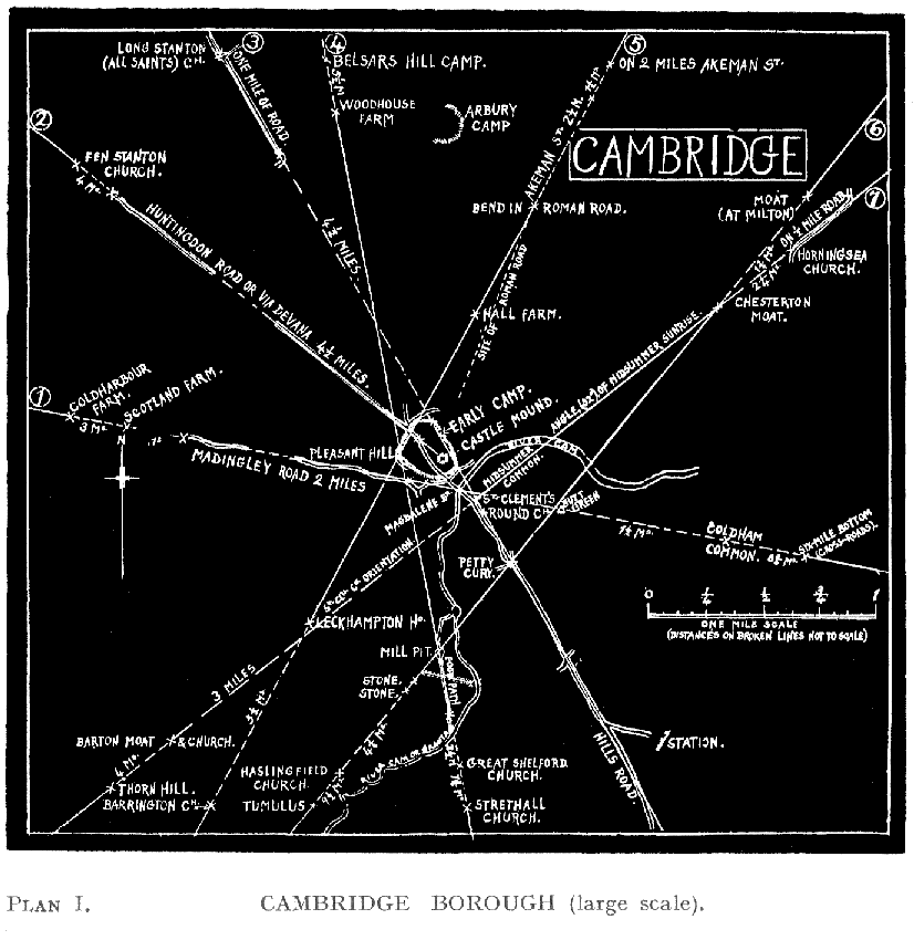
(Plan I.)
This is based on a larger scale than the subsequent maps, and in order to bring in outside confirming mark-points the dotted lines indicating such extension are not to the same scale, the distances being marked.
The following are the seven tracks or alinements:—
| 1 | Coldharbour Farm—Scotland Farm—Two miles of the MaddingleyMadingley Road (this although undulating obviously based on a slight line)—Magdelene or Great Bridge over the Cam—Triangulation point on Butt Green—On present footpath through Coldham Common—Six-Mile-Bottom Cross-roads. |
| 2 | Fen Stanton Church (on adjoining Ord. map)—On 4½ miles of Huntingdon Road or VIA DEVANA—Site marked for ancient Cemetery in Girton College grounds—Great Mound of Cambridge Castle. |
| 3 | Long Stanton (All Saints) Church—A mile of straight road—Eastern vallum of Cambridge Castle Camp—St. Clements Church—The Round Church—Petty Cury cross-roads—On a full mile of main streets and part of the Hills Road. |
| 4 | Belsars Hill Camp (adjoining map)—(Woodhouse Farm)—Pleasant Hill (corner mound of Cambridge Camp)—Mill Pit and footpath—Great Shelford Church—Strethall Church. |
| 5 | Roman Camp. S. of Ely (on adjoining map)—On two miles of Akeman Street (adjoining map)—after a gap, on another two and a half miles of the site of Akeman Street—Pleasant Hill, site of mound—(Leckhampton House)—Barrington Church. |
| 6 | Milton Moat—Chesterton Moat—Petty Cury cross-roads—Mill Pit and two boundary Stones beyond it—Haslingfield Church—Tumulus below Morden Grange. |
| 7 | Half-a-mile of road at Horningsea—Horningsea Church—Chesterton Moat—Across Midsummer Common over present site of Victoria Bridge—St. Clement’s Church (oriented at the angle)—Barton Moat and Church—Thorn Hill. |
{17}
{Plan I}
I expect that those with a local knowledge of ancient town sites of chapels and churches will find corroboration in these. And it is, I think, likely that ancient mark-stones might be found if looked for. No. 2 is apparently a Midsummer Sunset line (see Admiral Boyle Somerville’s table in Appendix), and No. 7 one for Midsummer Sunrise, this last confirmed by the name of the Common and by the orientation to the line of St. Clements Church. Numbers 9, 14, and 19 in the next map and chapter, ought to have been marked in this one, but were discovered too late.