{297}

THE HURLERS.

BY C. W. DYMOND, F.S.A.

(Read April 16, 1879.)

Link to Dymond's plan
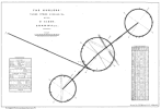
Dymond’s plan
The three stone circles, with two detached outliers, known from early times by the name of The Hurlers, are situated in the county of Cornwall, partly on the common of Carnedon Prior, in the parish of Linkinhorne, and partly in the adjoining parish of St. Cleer. Nothing approaching to a correct plan of these interesting relics of a remote past (in some respects the finest of their kind in Damnonia) having, so far as I am aware, been published, I have recently submitted them to an accurate survey, the results of which are embodied in the accompanying plan.[297.1]

The district in which these remains occur is a remarkable one, a narrow strip of it twelve miles in length, which extends north and south from Liskeard, containing within its limited area an unusual number of natural and antiquarian curiosities. Its southern end is marked by the megalithic circle of Duloe, from whence, journeying northward two miles, brings us to the famous well of St. Keyne, and, three miles farther, to the remains of the castle of Liskeard, of which little more than the site can now be traced.[297.2] Beyond, in the same direction, Roundabury, an ancient camp or amphitheatre, nearly obliterated by the plough, may yet be seen in a field by the road-side. At two and a half miles from Liskeard we reach the village of St. Cleer, with its restored ancient well and carved cross. Hard by, to the right, on a hill, stands the fine dolmên called Trethevy Stone; while, a little farther to the left, is found the inscribed sepulchral monument called Doniert’s Stone, with its companion, The other Half Stone. On the down, two miles ahead, bristle Long Stone, a tall carved cross, and the Hurlers, overlooking ancient tin stream- {298} works in the valley below, which testify to the local industry of early historical periods. A mile more, and the traveller stands in wonder at the foot of that great natural tour de force, the Cheesewring; and, if he be not wearied by his walk, he may find on Kilmarth Tor, one mile and a half in advance, and at the northern extremity of our line, the most perfect, and, in some respects, the finest rock-basin in Cornwall or Devon.

Old writers who have mentioned the Hurlers, as might have been expected, were unable to throw any light on their origin and use. Having no trustworthy evidence to adduce, they were limited to the record of popular tradition, and to the pathless field of conjecture,—their reports of the former being generally reproduced with a faithful monotony which is far from being instructive. Nevertheless,—though at the risk of some repetitions,— it maybe well to bring together, not only these early accounts, but also those of later explorers who have written from personal observation, before proceeding to describe the present condition of the remains, to analyse their features, and to note their analogies.

There is no mention of these antiquities in the earliest topographical notices of Cornwall, which are contained in the Itineraries of William of Worcester, temp. Edward IV, and of Leland, temp. Henry VIII. The first-written account is, probably, that of Norden (circa 1584) who thus describes[298.1]

“The Hurlers, certayne stones raysed and sett in the grounde of some 6 foote high and 2 foote square, some bigger, some lesser, and are fixed in suche straglinge manner as those Countrye men doe in performinge that pastime Hurlinge. The manner of the standing of theis stones is as followeth”:—

Here he gives a well engraved view showing thirty stones, of nearly equal size, promiscuously but artistically grouped—a purely imaginary picture, utterly valueless for scientific purposes, and, therefore, unworthy of reproduction. He concludes—

“This monumente seemeth to importe an intention of the memoriall of some matter done in this kinde of exercise, thowgh time haue worne out the maner.”

Carew, writing before 1586, has the following passage:[298.2]

{299}

Not farre hence, [from Doniert’s Stone] in an open plaine, are to be seene certaine stones, somewhat squared, and fastened about a foote deepe in the ground, of which, some sixe or eight stand vpright in proportionable distance: they are termed, The hurlers. And alike strange obseruation, taketh place here, as at Stonehenge, to wit, that a redoubled numbring, neuer eueneth with the first. But far stranger is the country peoples report, that once they were men, and for their hurling vpon the Sabboth, so metamorphosed. The like whereof, I remember to haue read, touching some in Germany (as I take it) who for a semblable prophanation, with dauncing, through the Priests accursing, continued it on a whole yere together.”

Camden, who, in the sixth edition of his Britannia, printed in 1607, acknowledges that Carew had been his chief guide through Cornwall, and who, doubtless, follows his description, writes (circa 1586) thus of the Hurlers:[299.1]

“A great many stones likewise, in a manner square, are to be seen upon the adjoyning plain; whereof seven or eight are at an equal distance from one another. The Neighbours call them Hurlers, out of a pious belief that they are men transform’d into stones, for playing at ball on Sunday. Others will have them to be a trophie in memory of a battle; and some think they have been set for boundaries; because in such Authors as have writ about Bounds, they have read, that large stones us’d to be gather’d by both parties, and erected for limits.”

To this the translator adds:[299.2]

“Near to these [the rocks of the Cheesewring] are the Hurlers, which are oblong, rude, and unhewn stones, pitch’d in the ground on one end, standing upon a down in three circles, the centers wereof are in a right line; the middlemost circle the greatest. They seem neither to be trophies nor land-marks (as our Author conjectures) but burying places of the ancient Britains. For The other half stone (mention’d by Camden) not far from those Hurlers, appears by the inscription to have been a sepulchral stone. And that too call’d the Long-stone, standing in the downs about half a mile from the Hurlers, above two yards and a half high, with a Cross on both sides, was doubtless a funeral monument.”

In a Latin account of this district, published at Amsterdam in 1661, the following has reference to our subject.[299.3] After noticing the Cheesewring—

“Saxa etiam plura æquis disposita spatiis. Incolis Hurletii. Pilæ quandamThus in Harvey. Read ‘quondam’ ? fuisse creduntur, sed in saxa mutatæ, quod vulgus diem illis dominicum profanaverit.”

About the year 1685 this neighbourhood was visited by {300} William Hals who, evidently adopting Carew’s terms to describe what he saw, writes[300.1]

“In the open downs are to be seen a great number of moorstones, some artificially squared, and in a perpendicular manner, about three feet high, fastened at the bottom in the ground. Eight of them stand much longer, or higher, than the rest, and at a proportionable distance. They are commonly called the hurlers. For the old wives’ tradition says, they formerly were men, and perhaps clever fellows too, but so very prophane and wicked as to be made exemplary monuments to posterity. For the wretches playing a match at hurling, whirling, or casting a ball upon a Sunday, became objects of God’s judgment, and were thus transformed into stones. Did but the ball which those hurlers used, when flesh and blood, appear directly over them, immoveably pendent in the air, one might be apt to credit some little of the tale. But as the case is, I can scarce help thinking but the present stones were always stones, and will to the world’s end be so, unless they will be at the pains to pulverise them. I am inclined to guess too, notwithstanding what my grandmother said to the contrary, they were by human art set up, like those others [two crosses previously noticed] by the highway, as funeral monuments for such pious christian hurlers only as St. Paul himself was ; whose spiritual hurling, or race-running, for the eternal prize, his sacred Epistles abound with. I say, from some such circumstances probably those stones might be denominated hurlers, (if from their first erection they were called so) viz. hurlers spiritual, not carnal.”

The author of the small work, from the additions to which by its editor the foregoing Latin extract is taken, thus mentions[300.2]

“The Hurlers—about 22 great stones standing upright on one end, in a plain place of ground: so called as the tradition goes, from so many men being at Hurling on a Sunday, and so for their sin for Sabbath breaking, by God Almighty turned into those stones as a monument of disobedience and sin, like that of Lott’s wife. But the truth of the story is,—it was a burying place of the Britons, before the calling in of the heathen sextonThus in Harvey into this kingdom. And this fable, invented by the Britons, was to prevent the ripping up the bones of their ancestors, and so called by the name of The Hurlers to this day.”

In one of the Additions to this account the editor gives particulars as to the number of stones, diameters of circles, and distances, which are wrong in almost every item.[300.2]

Next comes the description by Dr. Borlase, written before year 1754:[300.3]

“Some Circles are near one the other, and their Centers in a line, {301} to signify, perhaps, that they were intended for and directed to, one use. Of this kind is the Monument called the Hurlers, in the Parish St. Clare,[301.1] Cornwall; the Stones of which, by the vulgar, are supposed to have been once Men, and thus transformed, as a punishment for their hurling upon the Lord’s Day. This Monument consisted of three Circles from which many Stones are now carried off; what remain, and their distances, may be seen.”[301.2]

The perspective view published by Dr. Borlase (evidently somewhat conventional in drawing) shows sixteen stones in the northern circle, nine of them erect and seven prostrate; seventeen stones in the middle circle, eight of them erect and nine prostrate; twelve stones in the southern circle, three of them erect and nine prostrate. Now, though it is probable that the total of stones then existing is here shown nearly correctly, it is impossible to accept this perspective plan as an unimpeachable authority, for the number of those which are shown as standing in the middle circle is fewer by two than the number found to be still rooted in their beds. Yet it seems to offer some evidence that, since this author visited the spot, about three or four stones may have disappeared from the northern and middle circles respectively, and one from the southern circle.

Following Dr. Borlase, after an interval of half a century, Thomas Bond, author of Topographical and Historical Sketches of the Boroughs of East and West Looe, visited and described the Hurlers. He says[301.3]

“Cn the 6th of August, 1802, I went with a party of friends to see these natural and artificial curiosities mentioned by Camden.... The Hurlers .. were found to be moor-stones of about 5 or 6 feet high, forming two circles, one without the other (not as represented in Hals’ ‘Parochial History’, but like that in Borlase) the circle nearest Cheese Wring less than that of the other. Some of the stones are fallen down, and remain where they fell; and others have probably been carried off for gate-posts, and other purposes. The areas of the circles are not level, there being many pits in them, as if the earth had sunk over large graves. I confess I was not much struck with the appearance of these famous stones, not having faith to believe they once were men.”

A few years later, C. S. Gilbert—possibly in this case from personal observation—thus writes:[301.4]

{302}

“In the Parish of St. Cleer, three miles north of Liskeard, are the remains of a monument called the Hurlers. When perfect it consisted of three contiguous circles, of upright stones, from three to five feet high, the centres of which are in a line, though their diameters are not the same, the middlemost circle being larger than the end ones, which appear to be of a similar size. Many of the stones were carried away some years since. The common people suppose that the stones forming this monument, were formerly men, and that they were thus transformed as a punishment for hurling (a sport once common in Cornwall) on a Sunday.” [And, in a note, the author adds], “This was evidently once a place of worship, though the centre stone, or altar, does not now appear.”

Lastly, Sir J. Gardner Wilkinson, in the volume of this Journal for 1862, has the following note:—

“Of the Hurlers, no one of the three circles is sufficiently preserved to enable us to ascertain the original number of its stones. In the first, to the south, two only are standing, in the second ten, and in the third six: but the first and third may each have had about twenty-four, and the second about thirty or thirty-one.”

Many other authors have mentioned the Hurlers; but, so far as my researches have extended, they have, apparently, all been content to quote the descriptions of others; and, doubtless, in most instances have never had an opportunity of seeing the objects in question.

Passing, for the present, over the errors of fact which abound in the preceding meagre accounts, it may suffice to notice here two or three other points that suggest some comment. It will be observed that there is a slight discrepancy between various renderings of the popular tradition, some of which represent that the men, and one that the balls were transformed into stone. With regard to the statement of Carew that the stones were “somewhat squared”, it may be remarked that they exhibit no appearance of having been artifically shaped,—any regularity of form which they present being due to the planes of stratification and cleavage which cause this moor-stone to separate into rhomboidal masses. The opinion of Camden’s editor that these circles were burying places needs to be fortified by stronger evidence than the accident that monuments certainly sepulchral, and, evidently, of much later date, happen to exist in their vicinity. Lastly, there is the curious word Hurletii in the Amsterdam description, which appears rather to be a corrupt Latinized form of the English name than to suggest that it is a survival of an earlier {303} one by which these remains may formerly have been known, and of which the word Hurlers may itself be a corruption.

The site of the Hurlers is a flat saddle of the down, from which there is a gentle rise toward the north and south, and a slight dip toward the south-east and south-west. The northern circle is on the highest part of the ground, and the southern on the lowest, nearly on a level with which are the two detached stones. All are composed of granite, the local rock. Their individual circumstances are clearly shown by the original plan, from which the facsimile plate illustrating this paper has been reduced.

This plan shows all the stones which are visible within the area occupied by the remains. To the north of the northern circle, and also to the south-east of the southern one, occur a few blocks lying on or buried in the ground, scattered quite irregularly, and offering no evidence that they ever had any connexion with the artificially arranged group. It is quite possible that some of them may have been removed from thence; for violence has here, certainly, been long at work—the down being a much trodden thoroughfare, and the temptation great to utilise the handy materials in erecting the fences and cottages which are dangerously near. Since my first visit in 1870, No. 13 in the northern circle has been blasted to pieces which have not been removed—though only the eastern corner remains exactly where it was: in like manner, a large piece has been broken from No. 6 in the middle circle, and carried away. Their original forms, as sketched on that occasion, are dotted in the plan. One stone—No. 7 of the middle circle—is wedged into its place by another, nearly of the same width and thickness, driven down close to it, till its top is level with the ground.

The bearings of the various groups of stones were carefully observed with a prismatic compass; and the assumed local deviation of the needle, according to the best evidence I have been able to obtain, must be very near to the truth.

No perspective sketch is appended to the plan, for the simple reason that the stones are scattered over so wide an area in proportion to their size that they cannot be grouped into an effective picture.

Several different statements (none of them correct) as to {304} the diameters of these rings have been published;—the errors evidently arising from the method of measurement, which appears to have been performed in a hap-hazard way on the ground, instead of being carefully deduced from a large and accurate plan. The true diameters are recorded on the illustrative plate; and are those of the dotted circles drawn thereon from centres experimentally found after the measured details were plotted. It will be observed that, in the cases of the northern and southern peristaliths, these circles pass very nearly through the centres of most of the standing stones, and closely coincide with ends of the prostrate ones; but the middle peristalith is not quite so skilfully ranged. It exhibits several instances of eccentricity which it is impossible to co-ordinate with any regular curve. These aberrations are, however, not quite so great as at first sight might appear; for, if the leaning stones were restored to their original erectness, they would approach more nearly toward coincidence with the dotted line. Due allowance has been made for these existing displacements in searching for the centre of the average middle circle. Though it is possible that certain members of megalithic structures may have been designedly fixed in an inclined position, yet it is evident that most of the examples which occur are the result of natural causes. Originally badly founded, their instability has been increased by their lee-sides being the resort of sheep for shelter against prevailing storms. Hollows are thus worn which, in wet weather, become pools: then the soil is softened, and the stones planted therein lose their support.

The number of stones now remaining, exclusive of those scattered ones which cannot now be identified with any portion of the work, is 39; and they are thus distributed:—

Group.Erect.Prostrate.Total.
NorthernCircle6713
Middleditto10313
Southernditto2911
Outliers 22
Totals201939

A reference to the table on the plan will show that none {305} of these stones are of imposing size. The pre-eminence of the Hurlers among antiquities of the same class in Cornwall is clue to the superior diameters of the rings, and to their occurring in a group. It has been usual to represent them as ranged with their centres in one straight line; but this is not the case: the centre of the southern circle is 24 feet to the east of the line passing through the centres of the other two; and, in like manner, that of the northern circle is 24 feet 6 inches to the east of the line of centres of the middle and southern circles. The two sentinel-stones to the west stand on a line which, produced, is approximately a tangent to the middle circle. Both of them are nearly of one shape; both lean in the same direction, and nearly to the same degree.

The “dyke” which intersects the middle circle is continued for a considerable distance in both directions. It is precisely like others which are frequently found in similar situations, consisting of a slight bank and a shallow ditch; and, probably, was thrown up merely to mark the limits of common-rights. The neighbourhood being devoted chiefly to mining, the surface of the down is here scored by pits—apparently excavated in the pursuit of mineral traces. Many of them might, on a hasty glance, be easily mistaken for rifled barrows, none of which, however, have been found on the site. Two of these pits, occurring nearly on the rim of the middle circle, are shown in the plan, as it is quite possible that they may originally have been hollows left by removed stones, and afterward, artificially enlarged.

The cross before referred to stands a little off the roadside, about half a mile south of the circles. Belonging, doubtless, to another and a later age, it is not within the scope of this paper to describe it. Hals says he saw another stone with a cross faintly cut upon it by the side of the road, apparently between this cross and Doniert’s Stone. Perhaps he refers to a slender pillar of granite, 7 feet 4 inches high, uniformly 9 inches square, and rough-hewn on every side, which stands near the fork of the roads leading south and south-west to Doniert’s Stone and Gambel; but this looks much too modern to be anything else than a boundary or guide-post. It stands about 1,500 paces, or say, three quarters of a mile, south by west of the circles, and nearly in the prolongation of the line passing {306} through the centres of the middle and southern ones; and is rather more than a quarter of a mile south-west from the cross.

There is very little, if any, evidence tending to show that circles such as these were laid out on any plan which fulfilled astronomical or numerical conditions,—unless, perhaps, we except the numbers 9 and 19, which have been observed to prevail in those of convenient diameters;—but, to antiquaries who think they see some traces of regulated alignment, it may not be useless to point out the parallelism which exists between the Hurlers and the remains at Stanton Drew.[306.1] In both instances there are three peristaliths relatively disposed, roughly speaking, toward the same points of the compass; and in both the line of their centres is broken, the northern link trending more toward the east than the southern. In both we find that the middle circle has the greatest diameter; in both, also, there are the two detached stones in nearly corresponding directions, though not quite at corresponding distances. The most noteworthy general differences are, that the relative elevations of the northern and southern circles are in the two cases reversed, as are also their respective diameters.

A little study of our plan, with the aid of a scale, will reveal the fact that, taking the stones as they are on the ground, the intervals between those of the northern circle (the fallen as well as the standing ones) are all either about 12½ feet, or some multiple of that distance. Indeed, the uniformity is such that, if analogy favoured the assumption that it held place in every part of the periphery (which, however, it does not), we should be able, with an approach to certainty, to settle what was the complete number of the stones. This would be found to be 29, with an average interval from centre to centre of 12 feet 4 inches. The average interval of the middle circle is 15 feet 2 inches; and the theoretic number of stones is again 29—the actual distances between those which are either standing, or which have evidently fallen without subsequent displacement, varying from 14 feet to 15½ feet. The southern circle is so incomplete, that still greater uncertainty attaches to speculations on its original condition. {307} The existing intervals, however, are either coincident with, or are so near to being multiples of, the calculated average (12 feet 7 inches), that if all the missing stones were originally equidistant, the theoretic number of members in this circle would clearly be 27.

As to the etymology of the word Hurlers, the Rev. J. Bannister, in his Glossary of Cornish Names, gives but two suggestions;—(1) that it may have been derived from ur, fire, light, and lar, the hearth;—(2) that the name was naturally suggested by the resemblance borne by the scattered stones to men engaged in the popular Cornish game. Few antiquaries will have any difficulty in making their election, if the choice lies between these two alternatives.

Footnotes: page number + note number. Moved to here September 2015.

297.1 The photo-lithographed facsimile has been necessarily reduced to so small a scale that some details of the original are not very clear.
297.2 It was destroyed before the time of Leland, who says, “There was a Castel on an Hille in the Toun side by North from S. Martin [parish church]. It is now al in Ruine. Fragments and Peaces of waulles yet stond. The site of it is magnificent and [looketh] over al the Toun.”
298.1 Speculi Britanniæ pars, Cornwall, p. 94.
298.2 Survey of Cornwall, ed. 1769, p. 129
299.1 Britannia, ed. 1695, p. 9.
299.2 Ibid., p. 23.
299.3 History of the Parish of Linkinhorne, by W. Harvey, written in 1727, first published in 1876, p. 23.
300.1 Hals’ Parochial History, pp. 48, 49, quoted in Polwhele’s History of Cornwall, ed. 1816, vol. i, p. 144, notes.
300.2 Hist. Par. Linkinhorne, p. 13.
300.3 Antiquities of Cornwall, 2nd ed., 1769, pp. 198,
301.1 Some of them are in the parish of St. Cleer, but the greater part are in the contiguous parish of Linkinhorne.
301.2 Plate xvii, fig. vi, p. 206.
301.3 Published in 1823: quoted in Davies Gilbert’s Parochial History of Cornwall, 1838, vol. i, p. 184.
301.4 Historical Survey of the County of Cornwall, 1817, vol. i, p. 171.
306.1 Of which an account with a correct plan appeared in the volume of this Journal for 1877, pp. 297–307.