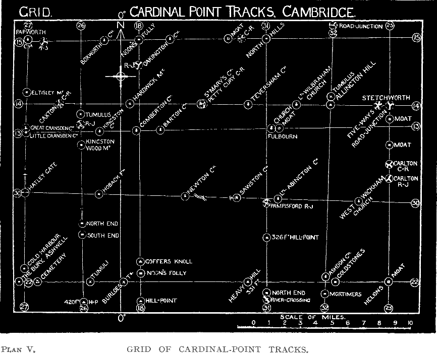
{31}
(Plan V.)
We are all familiar with the arrow and its cross-bar so essential to all maps to indicate the axis of the world’s rotation, that is, the true north. Surely this precise direction and its record must have been equally essential to the science-men of old? One association of such men (I am not enquiring whether these were the ones who made the alinements in my maps), had, according to Julius Cæsar, “many discussions as touching the stars and their movements, the size of the universe and of the earth, the order of nature”—“they do not think it proper to commit these utterances to writing, although in almost all other matters they make use of Greek letters.” If not in writing, why not recorded on the land itself?, especially as all traditions of this particular sect connect them with out-door ritual, done “in the eye of the sun.”
Another indicating clue (not followed up in this district), is given by Aegelnoth’s Stone, where, according to a record in Hereford Cathedral Library, a Shire-mote met in the reign of Cnut. Canon Bannister, in his Place-names of Herefordshire, under “Aylestone Hill, Hereford,” quotes it as being Aegelnothes stan ante 1038 (Kemble), and remarks: “Aegilnoth or Aegil is the sun-archer of Teutonic mythology,” but proceeds (as is a passing custom of place-name experts), to assign the name to “a prosaic English settler.” But it is strange that according to the English Place-name Societies volume of Buckinghamshire, not only does Aylesbury contain this same name of Aegil, but it is found also in Aylesworth (Nth.), Aylesford (K.), Aylesbeare (D.), and Aylestone (L.)
I surmise that another Aegil-stone is to be found in the AGGLESTONE standing on a mound at Studland Heath, Dorset. This is illustrated and described in Mr. W. Johnson’s Byways in British Archæology; he notes that “much pagan tradition is associated with this block,” and ascribes some “rock-basins” on it to natural agencies. It has the position and appearance of a mark-stone, and it seems possible that the hollows were for beacon-fires.
Frankly, until I was well on with the task of the Cambridge map-work, I did not suspect that these early science-surveyors, as well as making {32}{Plan V}{33} purely travel alinement, had laid down on the land the sun-archer’s direction-arrow, north and south.
A place-name revealed it. Two miles east of Royston is Noon’s Folly Farm; the “Folly” indicating a sighting point on a track, and the “Noon” element suggesting that this track might be a seasonal or meridional one. Searching the map for other seasonal names, I found—14½ miles away—another Noon Folly Farm. It was almost precisely north of the first one. But the line between just missed the tree-clad Goffer’s Knoll, with a tumulus on its apex. However, one-eighth mile west of the lower farm, is a point or clump on the map, which I think to be the true Noon’s Folly, and the line (No. 18) going through this to the Upper Folly is one degree only east of north.
This led me to investigate an east and west alinement through Great St. Mary’s Church, for which I had seen some evidence. This is No. 14, and goes through a circular pre-historic hill enclosure, Allington Hill, St. Mary’s being also oriented on the line.
Discoveries of more and more cardinal point alinements on this map then came fast. Place-names called attention to No. 15 (east and west through the Upper Noon’s Folly), to No. 25 (with a moat called Helions, the Greek sun-name, on it), to No. 26 (with a North End and a South End place on it), to No. 31 (with a North End and a North Hills).
Seeing actual straight tracks on the map running north and south called my attention to Nos. 25, 26, and 27; also fragments east and west to No. 30.
I make no attempt to surmise “how it was done,” but point out that to find true north by an observation of greatest altitude of mid-day sun at certain seasons does not involve (as does sunrise or sunset observation) the serious complication of differences of horizon elevation due to hills, and therefore the north might have been found first, and a right-angle to this then laid out for east and west. A Polar-star observation would be another way.
I found six northern and five eastern alinements on this map, and give them in Plan V. Some little variation from the true axis would be expected. But there is not more than 1 1/8 degree from present true orientation in the northern ones.
The surmise of being made in pairs has evidence in that pairs almost exactly at right angles to each other are there on my diagram, which is not a mere sketch but accurately giving the bearings. The cardinal-point alinements I have since found in other districts are also in similar pairs.
Definite evidence will be seen by surviving lengths of roads on the Ordnance map in the cases of 25, 26, 27, and 30, that these alinements were used for actual tracks.
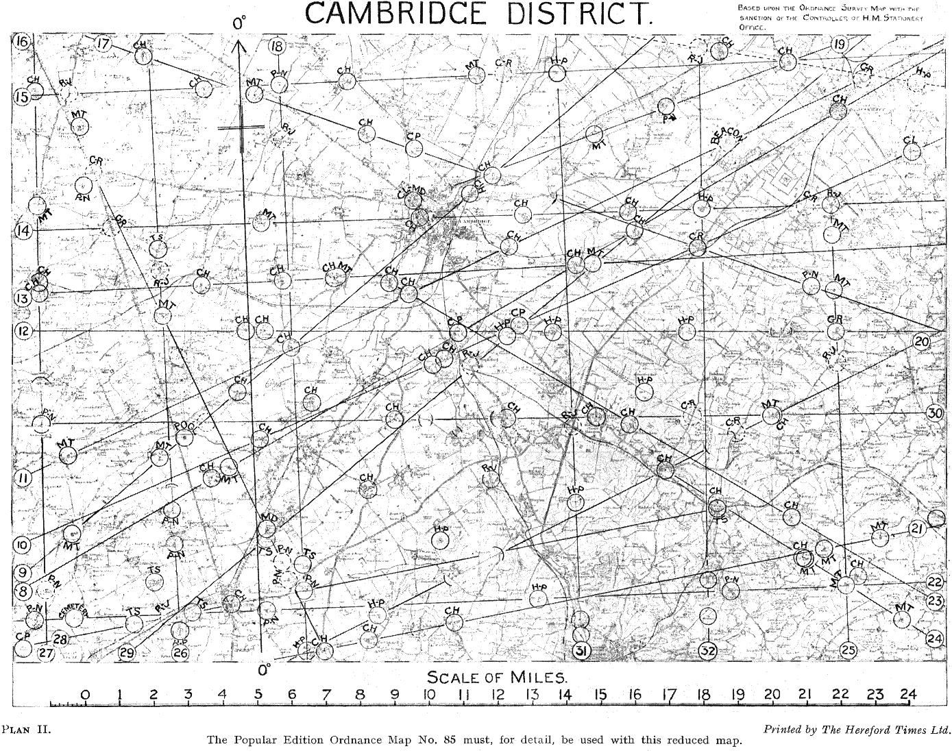
All these cardinal-point alinements are also marked on Plan II. (folding), and details of each one are given in Chapter IV.
{34} The amount by which each line departs from the true cardinal-point is given in figures in Appendix B.
A remarkable feature is that each northern line has a counterpart in one of the eastern lines within half a degree from being at right angles to it, and one pair (26 and 13), has an exact right-angle relation. The table below shows this:
| Nos. 27 and 30 are 17/40ths degree from 90°, and cross at Hatley Gate. |
| Nos. 26 and 13 are exactly at right angles. |
| Nos. 25 and 14 are 9/20ths degree from 90°, and cross at Stetchworth. |
| Nos. 31 and 22 are ¼ degree from 90°. |
| Nos. 18 and 15 are 1/5 degree from 90°, and cross at the Upper Noon’s Folly. |
| Nos. 32 and 30 are ½ degree from 90°. |
The above figures seem to me to indicate that these alinements were made in pairs, probably the Polar one first and the Equinoctial one made to it by some appliance for sighting, giving a right-angle, like the Roman Groma.
It happens that the meridian of Greenwich (0° Longitude), now adopted as the standard for time-keeping throughout the world, passes through this map, and I have imposed in Plans II., III., and V. the north and south indicating-arrow on it, with the east and west bar at right angles.
The striking grid of cardinal-point alinements, which I illustrate separately in Plan V., has some aspects which to me have been unexpected. There is a certain uniformity between the spacing of the N. and S. alinements, but not between the E. and W.
| Nos. 27 | and | 26 | are | 3.6 | miles | apart, | at middle | of map. | ||
| Nos. 26 | ,, | 18 | ,, | 3.65 | ,, | ,, | ,, | ,, | ||
| Nos. 18 | ,, | 31 | ,, | 8 | ,, | ,, | ,, | ,, | ||
| Nos. 31 | ,, | 32 | ,, | 3.95 | ,, | ,, | ,, | ,, | ||
| Nos. 32 | ,, | 25 | ,, | 3.9 | ,, | ,, | ,, | ,, | ||
| ____ | ||||||||||
| 23.1 | miles (checked by the total distance). | |||||||||
| ‾‾‾‾ | ||||||||||
The average of the above total, divided by six spaces, is 3.85 miles; it will be seen that the actual spaces on the map differ but little from this, and it looks as if this was intentional. The space between Nos. 18 and 31 is, of course, a double one, in which I do not happen to have found or marked the missing alinement. To be more precise, I found one which, although true N., had its chief mark-points in the Ely map. To find it, take a line from North Hill (5 miles north of Cottenham) and Cottenham Moat in the Ely map, down through the heart of Cambridge to Stone Hill and a moat at Elmdon. It probably picks up old sites at EmanuelEmmanuel and Jesus Colleges, but here my local knowledge is insufficient.
{35}It seems probable that there are six corresponding east and west alinements in this map in place of the five which I have found.
There is NOT THE SAME UNIFORMITY of spacing in these equinoctial lines.
| Nos. 15 | and | 14 | are | 4.1 | miles | apart, | at middle | of map. | ||
| Nos. 14 | ,, | 13 | ,, | 1.5 | ,, | ,, | ,, | ,, | ||
| Nos. 13 | ,, | 30 | ,, | 4.3 | ,, | ,, | ,, | ,, | ||
| Nos. 30 | ,, | 22 | ,, | 5.3 | ,, | ,, | ,, | ,, | ||
| ____ | ||||||||||
| 15.2 | miles (checked by the total distance). | |||||||||
| ‾‾‾‾ | ||||||||||
The average of above total, divided by four spaces, is 3.8 miles. This is a curiously near figure to the average of the north and south lines. The ACTUAL spacing, however, departs widely from this theoretical average.
As I know that some minds will at once jump at a probability of the Romans having done this as part of a systematic land survey into squares, let me mention that these figures do not fit in with Roman miles, nor with the spacing between pairs of north and south lines I have to quote in Herefordshire and Radnorshire, which are 6.1 and 5.45 miles respectively.
My own general view is that a geometric land-survey system is quite incompatible with an alinement system (such as I illustrate), which takes HIGH PLACES as mark-points; and that, although a rough ideal of a fairly uniform distance between these utility cardinal-point lines (laid down for communal information) was attempted, the older plan of hill-points for terminals prevailed.
I should also mention that the above spacing does not accord with the planning of land into “Quintarial limites forming a Possessa (810 acres)” which Sir MontagueMontagu Sharpe adopts for the plans in his book on Antiquities of Middlesex (G. Bell & Sons, London, 1919), these being 1 1/8 inch square.
Moreover, unless the connection between barrows and camps of dates at least as old as the Iron Age is denied to the whole system, there was no sufficient private property in land at the time to make any such system of land-survey useful or likely.
The strange fact that one of the best authenticated N. and S. alinements I know (that in Radnor Forest), goes through a CUP-MARKED stone, which also seems to have cardinal-point alinements in its cups, precludes, I think, a Roman origin for what I demonstrate.
CARDINAL-POINT TRACKS IN THE WEST.
Although this book deals with Cambridge local tracks, it is not out of place
to strengthen the case newly presented in this chapter with similar
{36}
instances I now find round my own neighbourhood, in places which I have
visited and explored for years past.
One find came through following up the Helions name. Near Much Marcle, Herefordshire, is an ancient manor-house now called Hellens, but Heliun in 1287, and Helyon in 1394. 45 years ago, when making a survey of Herefordshire Dovecotes, I photographed there the fine memorial one, dated 1642. To be brief the following north and south alinement comes down through it. Bishops Frome Church—Kingston Bridge (present River Frome crossing)—Munsley moated mound—Pixley Church—Hellens—Linton Church—Burton Manor. Crossing this is the Ledbury Church Lane alinement, which I photographed for my first trackway-book. It goes through Putley Church—edge of Aylton Churchyard—Putson (homestead)—Church Lane—Tower of Ledbury Church—Deadman’s Thorn—Eastnor Hill (highest point)—Northern vallum of Midsummer Hill Camp.
The reality of this as a trackway is confirmed by the skilled excavations made at Midsummer Hill Camp by Mr. I. I. Hughes, F.R.G.S., who found in the northern ditch an unusual feature, two paved ways of different dates, one a foot below the other. He makes a surmise “That the ditch may have been used at some time or times as a track.” Mr. Hughes did not know of my work, but the paved way he found is exactly at the spot where the above alinement crosses the Malvern Ridge, and in the same direction. He dates the Camp to be about, the Iron Age, and therefore the paved way must be as old or older. Details and plans of this in the Woolhope Club Transactions for 1924.
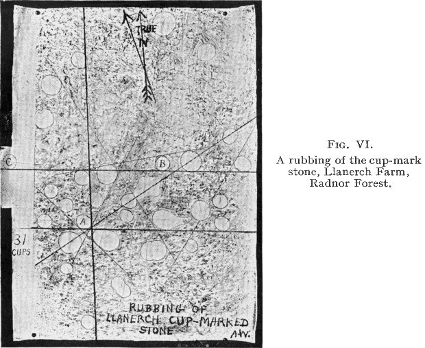
A CUP-HOLLOW STONE AS CARDINAL-POINT RECORD.
(Figs.
VI.,
VII. and
VIII.)
Dr. Graves, Bishop of Limerick, many years ago
called attention
to the frequent cases of alinement which he noted on Irish cup-marked stones.
He ventured the opinion that they were a kind of rough diagram of the
raths or mounds in the district, which he also found to aline in threes.
I have little personal knowledge of such stones, one in the Grimsel Valley, Switzerland, and the one I shall now mention, being the only ones I have seen or photographed. However, I find almost half of those illustrated in books (as Sir Jas. Simpson’s), show evidence of such alinement, and I illustrate and call attention to the fact in the Ley Hunter’s Manual.
I now see a striking connection between a cup-marked stone I know well, and a north and south alinement also well known, visited and photographed. I must give it briefly, but the whole subject requires detailed treatment beyond space available here. It is in the Radnor Forest district.
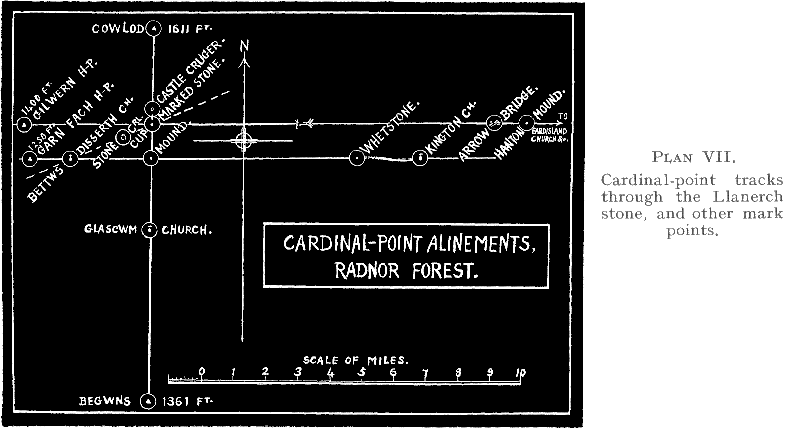
{37}{Plans VI, VII}
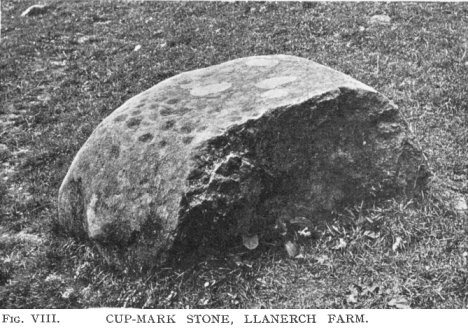
{38} Following a visit by the Woolhope Club in 1928 to that fine mound on Radnor Forest—Cruger Castle—(illustrated in The Old Straight Track), a fellow member (Mr. Walter Pritchard), working on alinements, discovered a fine cup-marked stone, at Llanerch Farm, a little south of the mound. I visited and photographed the stone the same year, and took a rubbing of the cup-marks on it, also taking as careful a bearing as possible, and marking it on the paper while on the stone. I also (as soon as I got home) tested for alinements, and inked in those of four cups which I found, as I considered lines of three to be of no value as proof. I could not at that time see any tangible proof of anything, and put it down to this (broken) stone having probably been moved. The reproduction I give is of this crude rubbing exactly as I finished it (outlining then the rather indefinite edges of the cups) in 1928, the magnetic and true bearings being then marked. I found, soon after, a north and south alinement through Cruger Castle and other good mark-points.
It was not until this present work on Cambridge maps began that I saw that this cardinal-point alinement actually went exactly through the cup-marked stone, that there were two or more east-and-west alinements crossing, just as I found about Cambridge, and, above all, that the lines which three years ago I had marked on this rubbing, DO CRUDELY REPRESENT ONE NORTH AND SOUTH AND TWO EAST AND WEST ALINEMENTS in connection with the cups. It seems to me good evidence of a pre-historic map-record.
In pre-historic times, where three or more circles (whether of earthen banks, stone-circles, or cup-hollows) aline, the basis of alinement is usually to the edge of the circle, that is, when the circles are the same size -they also aline by their centres, but not when they are of uneven size. Striking evidence of this will be found in the diagrams of The Hurlers (Cornwall), and similar circles at Stanton Drew (Somerset), given by the late Hadrian Allcroft in Vol. I., The Circle and the Cross, p. 250. The same fact can be traced in Figs. 41 and 47 in Lockyer’s Stonehenge, and this is why the lines in Fig. VI. are to the edges of the cups.
A Glasgow archæologist, Mr. Ludovic M. Mann, in his book Archaic Sculpturings (W. Hodge and Co., Edinburgh and London, 1915), detects an astronomical purpose in such stones in Scotland. He finds alinements through both the centres and the edges of the cups, and says: “We are apparently now on the verge of obtaining a clear conception of how pre-historic man worked to get his cardinal and solstitial points fixed, and what he understood of the movements of the heavenly bodies.” He goes on: “The apparently isolated cairns, the groups of standing stones far distant from each other, and the detached sets of rock carvings well removed from each other, may all form part of one widely spread design; and the surveyor of pre-historic monuments should endeavour to show this relationship in his charts.”
{39}
THE CARDINAL POINT ALINEMENTS IN RADNOR FOREST.
| a. | N. and S.—½ degree from true. Cowlod Hill, 1,611 feet—Cruger Castle Mound—Cup-marked stone at Llanerch Farm—Mound (locally called the Four Stones)—Glascwm Church—The Begwns (Beacon) hill point, 1,361 feet. |
| b. | W. and E.—½ degree. Circular 1,400 feet contour hill-point on Gilwern Hill—Cup-mark stone—1/3 mile of road near Yardro—Moated Mound near Hanton, Titley—Eardisland Church—Farm called Cornhill Cop—Caswell Moat in Leominster—Eaton Bridge crossing of Lugg. A long-distance line. |
| c. | W. and E. exact. Garn Fach, 1,250 hill-point—Bettws Disserth Church—Mound (Four Stones)—The Whetstone on Hargest Ridge—On 12 miles on mountain road—Kington Church. |
B. is minus one degree from being at right angles to the Begwns—Cowlod line. C. is half a degree short.
These three land alinements comprise a meridian line over good mark-points with two equinoctial lines crossing at two of the mark-points, one being the cup-mark stone.
{Fig. VIII}
{40} Refer to Fig. VI., untouched from when done three years ago, when I had no ideas about archaic cardinal points, and lines apparently representing (if crudely) these three lines will be seen. Is it an archaic diagram? The angle is not an accurate right-angle, but then the stone has a rounded, not a flat, surface. Dr. Wheeler gives only four cup-marked stones in all Wales, this being a fifth, so there is little room for accidental coincidence in these cardinal-point alinements passing through it.
Two other good east and west alinements pass through this northern track. They start from hill-points—Little Hill and Wylfre respectively, and a mark-point on the first is Turret Mound in Hell Wood, and on the other Hell Moat in Sarnsfield Coppice. Compare the “ Helion “ names.
All this ground is very familiar to me. I have visited half of the points named, and photographed many of them.
Note how in the cup-hollow alinements shown on page 20 of the Ley Hunter’s Manual there are again examples of lines at right angles. There three alining cups are accepted, as the total number present is only ten. But with the thirty-one cups present on the Llanerch stone, alinement of four cups is the minimum accepted.
I find another well-proved north and south line 5.45 miles east of this one, coming down through that “Four Stones” near Walton, illustrated in the Old Straight Track. One is also specified in another part of England, at page 224 of the same book.