{21}
Of the old roads of Britain the four mentioned in the “Laws of Edward the Confessor” are the theme of many who write on the subject. They are: “Watlinge strete, Fosse, Hikenilde strete, and Erminge strete.” To these may be added other famous ones, as Stane Street, Akeman Street, Sarn Helen (chiefly in Wales), Via Julia, Via Devana, Peddar’s Way, and The Pilgrim’s Way.
My investigation into such roads is not to decide what clan of men made them or when, but to investigate their evolution, and whether the usual assumption that each one was a distinct separately made organisation has any foundation, for there is no doubt that some of these names (as Stane or Stone), are generic ones applied to several roads.
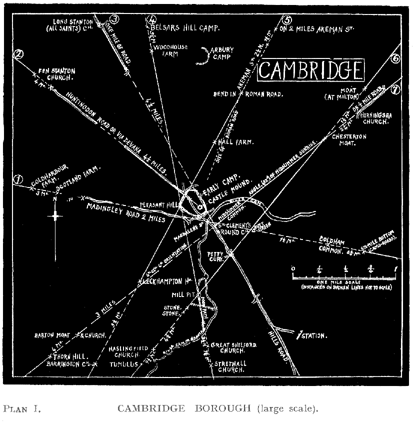
There happen to be in this map stretches of four of the above roads, namely, Ermine Street, Icknield Way, Akeman Street, and Via Devana, and also a local one named Ashwell Street.
It must not be assumed that the marking of these names on the map indicates the real course of the historic “Way,” and an open mind should be kept as to whether their origin was not that of a selected route over a great number of pre-existing tracks, which route being stoned and made efficient for more and more traffic, outlived the lighter trails from which it was formed and has in parts survived for us to see, when all the rest has gone underground.
The feature common to all, is that they run in straight courses, seldom of great length, but in sections at slight angles to each other, and lengths varying (in this map), from less than a mile to the 13½ miles of Ermine street. Obviously these straight sections were originally laid down by a sighting method, for no rule or stretched cord can be laid down on uneven land for such lengths.
To sight such lines across country, a terminal elevated point, either natural or artificial is required. By a study of such mark-points in alinements we can judge whether each section was made as part of one continuous whole—in which case you would expect to find one only sighting knoll in {22}{Plan III} {23}{Plan IV} line, and that one near the nodal point or angle—or whether each section was not part of an older track now vanished—in which case you would expect to find a line of mark-points beyond the nodal or angle of the named road being investigated, with occasionally fragments of surviving track.
This is what I investigate, and here give a digest of such branch extensions of the four named roads. I found it necessary to do this on two plates to avoid confusion with the close proximity of crossing tracks. Note {24} that the Street names are used as labels only, for bits so marked on the map, not as endorsing the map-maker’s guess that these bits were actually part of an original great road.
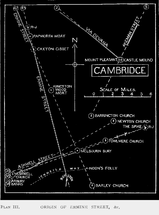
ASHWELL STREET (Plan III.)
| 33 | Ashwell Church—One mile of Ashwell Street past High Town Farm—A mile of field-track west of Melbourn—“The Spike” road-junction. |
| 34 | North edge of Arbury Banks—1¼ miles of Ashwell Street—Newton Church. This track is sighted on one of the three low hills, West Hill, Cockle Hill, or Clunch Pitt Hill, all on the line. |
| 35 | Site of “Cemetery” south of Littleton—Two miles of Ashwell Street—Foulmere Church—Three-quarter mile of straight field-road beyond ThirplowThriplow—“The Spike” road-junction. |
VIA DEVANA. (Plan III.)
| 2 | (This on Cambridge Borough Map). Fen Stanton Church—4½ miles of Via Devana—Cambridge Castle Mound; no track beyond here. |
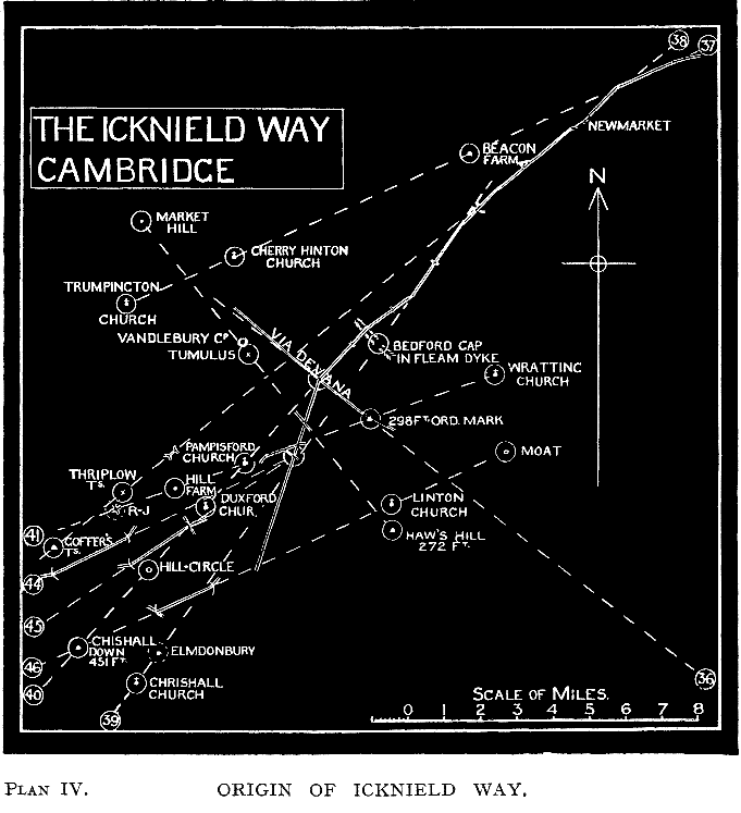
(Plan IV.)
| 36 | Boxworth Church—Half-a-mile of straight road at Dry Drayton—Wrangling Corner—One-and-a-half miles of Via Devana past Worsted Lodge—298ft. Ord. Triangulation Point. (A present road goes on as far as Marks Grave, but does not seem to be sighted). |
AKEMAN STREET. (Plan III.)
| 5 | Roman Camp S. of Ely—Two miles of Akeman Street (foregoing on the adjoining Ely map)—(Gap of 1½ miles)—Two-and-a-half miles of Akeman Street—Bordering Cambridge Castle Camp—Pleasant Hill Mound—Barrington Church. |
ICKNIELD STREET. (Plan IV.)
| 37 | Two miles of Icknield Way to Thetford Road junction north of Newmarket—Beacon Farm—Cherry Hinton Church—Trumpington Church—Tadlow Moat. |
| 38 | Two miles of Icknield Way (past Heath Stud Farm)—Short field-road—Road-junction—Road through Whittlesford—ThirplowThriplow tumulus —Goffer’s Knoll. |
| 39 | Three miles of Icknield Way past Six-Mile-Bottom—Through Fleam Dyke at Bedford Gap—Elmdonbury (ancient site)—Chrishall Church. |
| 40 | Two miles of Icknield Way north of Worsted Lodge—Road-junction {25} at Duxford—Circular Enclosure Hill-point—Chishall Down, a Hill-point of 451 feet, 10 miles from Icknield Way, but evidently the sighting point for this section. |
| 41 | West Wratting Church—298ft. Triangulation-point (same as No. 34 is sighted on)—One mile of a present-day road—Pampisford Church—(Hill Farm)—Road-junction, ThirplowThriplow—Tumulus at Melbourn—Limlow Hill with tumulus, 220 feet. |
ERMINE STREET. (Plan III.)
| 42 | Four Miles straight of Ermine Street down to Caxton Gibbet—Kingston Wood Moat—(Field Barn)—Melbourn Bury (earthwork)—(Munsey Farm)—Half-a-mile of road—Barley Church. |
| 43 | Road-junction east of Papworth St. Agnes—Moat east of Papworth Everard—Thirteen and a half miles of Ermine Street from Caxton Gibbet through Royston. |
Here follow some apparent connections with Icknield Way.
(Plan IV.)
| 44 | Road-junction near Pampisford Station—2¼ miles of straight road—Cross-road at Coach and Horses—Heath Farm Moat—420ft. point on Pen Hills. |
| 45 | Road-junction near Pampisford Station—Duxford Church—Two miles of straight road. |
| 46 | West Wickham Moat—Mark’s Grave Cross-roads—Linton Church—(crosses Icknield Way)—One-and-a-half miles of straight road—Chishall Down, 451ft. |
I present these two sketch maps for local investigation, and leave exact deductions to others. Sighting methods are certainly used, for almost all the roads are in lengths of straight lines. Note what a hotch-potch of eratic course, not necessitated by uneven ground, is for instance the Icknield Way from Newmarket downwards. How can such a route be explained unless parts of many previously planned roads had to be made use of?—an expediency method we adopt now, and have done for centuries.
Note the abundant evidence of road-alinements having once run far beyond their present use in these supposed trunk roads. And in some cases (33, 35, 38, 41, 42) fragments of remaining tracks confirm this.
The way in which the track-alinements (indicated first by other mark points), fall precisely on well-known hill-points with altitudes marked on the Ord. map, is most convincing as to the use of long-distance sighting methods. Goffer’s Knoll, Chishall Down, 420 point on Pen Hills, and {26} Limlow Hill are instances, all but the last-named actually having two different tracks in my maps sighted on them.
The complicated question how the Icknield Way (if correctly marked as coming through Royston), is joined up to the well-marked course coming through Newmarket, is perhaps answered by one or other of the three straight bits in alinements Nos. 44, 45, 46. Of these, two, Nos. 44, 45, radiate from a point on the Way itself, and it looks as if they might have been sighted in connection with it, and therefore not (in this case) older. The other is sighted on a distant hill.
I think (from the evidence) that a certain proportion of the straight pieces of roads which from their surface structure are known to be Roman, were really planned and sighted on then new sites by the Romans. These, I surmise, links necessary to join up the ancient straight tracks which they were adopting and reconstructing.
There is room for exhaustive study as to which of the mounds are Roman in their origin, and whether these also aline on straight tracks. Despite the official maps of Roman Roads, our knowledge on these points is—chaos.