{No pages 1–6}{7}
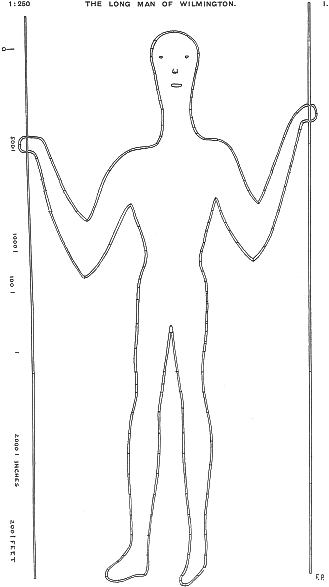
This figure is outlined by a narrow trench cut through the turf, on the north side of the South Down ridge, half a mile south of the church of Wilmington, Sussex; Lat. 50° 48′ 35″ N., long 11′ 22″ E. The hill rises about 500 feet above the plain, and the figure is at about 250 to 400 feet up. The general slope faces north, but the figure faces about 7° E. of N. In 1874 the figure was renovated by the Rev. W. Le St. Croix (Sussex Archaeological Collections, xxvi, 1875), at the expense of the Duke of Devonshire. The outline was cleared, and filled in with pale yellow bricks and cement, to preserve it from being overgrown or decayed. It is stated by the Rev. T. Bunston that the feet were then turned toward the east, but had previously been straight down, fore-shortened in view. (The Long Man of Wilmington, p. 3.) This seems unlikely, there is no trace of alteration about the feet, and farmer Dumbrell, who remembered all about the bricking, stated in 1918 that he did not know of any alteration having been made. The site was presented to the National Trust in 1926.
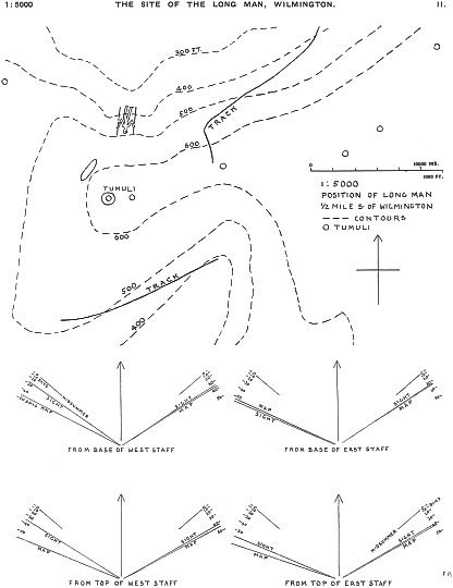
Looking at the plan (Plate II), it will be seen that the figure has been placed in the hollow of a natural bay; it is perceptible that the ground was flattened over the area, and heaps of this clearance seem to have been thrown into a gully at the side. The eyes are marked by plain hollows; the nose is a boss, possibly with recesses for the nostrils; the lips are a long boss of turf.
The steepest slope near the top of the hill is 38°; from the top to the head 33°; from the top to the feet 29½°; the slope on the Long Man itself is 28° 10′. The plan of the figure (Plate I) is as measured on the ground slope; if reduced to a horizontal plane on a map, it would be 11∙8 per cent. shorter. Each point measured is indicated by a line across the outline groove, the curvature between the measurements being drawn on the spot. The plan was made by stretching a line down the whole figure, and setting another line at right angles across the shoulders, and a parallel line across the legs. Standing at any required point, I held two tape measures; the zero of one was held on the long line by my wife, the zero of the other on a cross line {8} by my son, keeping the tapes square with the lines. I then read off the two distances to the spot on the ground, and plotted it at once on squared paper. Each of the 160 points was thus fixed. The field plotting was then reduced by photolithography from 1 : 200 to 1 : 250 on this plate. The errors here are probably less than a hundredth of an inch.
On the plan of position (Plate II) only the ancient details are entered. The contour lines of the Ordnance Survey have been slightly amended on the spot. The tumuli do not seem to have any connection with the figure, nor are any of them visible from it. An ancient track was noted coming up from the north-east, and then turning at a gentler slope to cross the hill. It does not seem connected with the figure, neither do the paths in modern use about the hillside. Some of these may be old but they are omitted here. On the south-west corner of the area included, there are banks of a pre-historic settlement, from which a long track slopes down the hill to the head of a steep valley, and doubtless led to a water hole.
The two staves held by the figure are of a length equal to double the distance between them, thus:—
| Distance apart at base | 1,370 | inches | |
| Length of east staff 2,768 | 2 × | 1,384 | „ |
| Distance apart at top | 1,402 | „ | |
| Length of west staff, 2,828 | 2 × | 1,414 | „ |
| 1,392 | |||
| Mean difference 15 inches | ± | 8 | „ |
The only ancient measure that is related to this is 120 feet of 11·60 ± ·06 inches, identical with the Etrusco-Roman foot of 11·61 ± ·01 inches. This foot is already known in England, the great circle of Stonehenge being 100 feet in diameter, though, it is slightly larger in that instance, 11·68 inches, 120 of which is 1,401 inches, or well within the above variations.
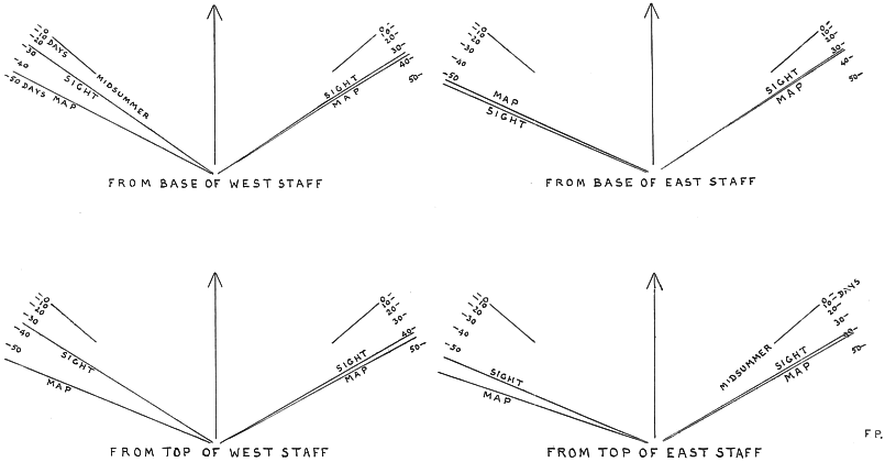
Suggestions have been made that the figure is represented as opening the gates of the underworld, or of heaven, and that there is some relation between the position of the sun and the staves. The supposition that the staves are not completely lighted till the equinox is far from true. The dip from the edge of the hill to the feet of the figure is 29½°, which is the altitude of the sun twenty-six days before the spring equinox. Even the top of the figure would be within sunshine by 16 days before the equinox. {9} Another supposition is that the sun lights the staves at rising and setting. In order to test this, observations were taken of the direction of the horizon to each side, from the top and the base of each staff; the north was identified by the bearing of a distant point marked on the map. The results are stated at the lower part of Plate II. The “sight” directions are those observed on the spot; the “map” directions are as read off by marking the same altitude between the map contours; to the western horizon they differ from the “sight” owing to the hill profile being so near, and the slopes between contours being irregular. Besides these, there is added here the point of midsummer sunrise, defined by the sun’s centre, allowing for refraction; the scale of the place of rising is added for every ten days before and after the solstice. There are various limits thus indicated, of 28, 33, 35, 35, 40, 42, 56, 56 days. Some of these might be thought to mark one of the May festivals of 37 and 51 days before midsummer, or the August festival of 41 days after that. The fixed conditions of the locality, however, make it impossible to suppose any adjustment to a given date, and all we can say is that the figure is placed in a selected position, so that some of the observations that might be chosen would serve to mark a festival date. Of course, the ancient observations would not necessarily have been made on the spot, as the hill shadow at sunrise or sunset would be seen from the plain, day after day reaching nearer or farther from the staves.
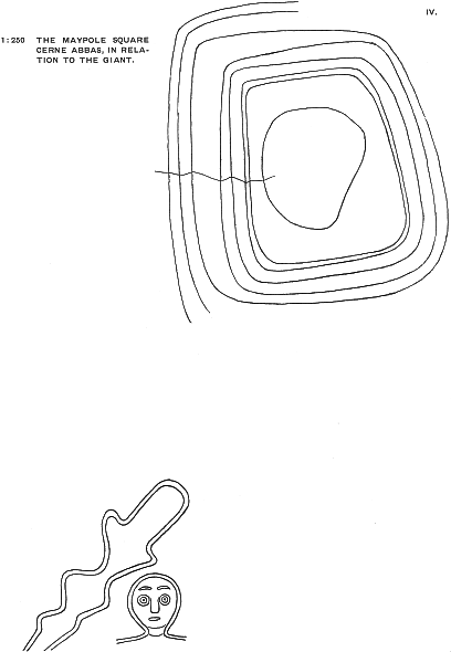
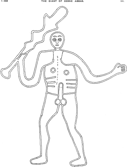
This figure is outlined by trenches cut through the turf, which are worn in the chalk by denudation to two feet in depth; part of this hollowing may be due to the custom of scouring the trenches, to remove any grass that springs in them. The position is one quarter of a mile north of the church of Cerne Abbas; lat. 50° 48′ 48″ N., long. 2° 28′ 24″ W. The base of the figure is about fifty feet over the plain, and it slopes up about two hundred feet, or one hundred feet vertical. A small earth bank enclosure is on the top of the spur of the hill above it (see Plate IV). The site of the figure was enclosed with iron hurdles by the late General Pitt-Rivers, and his son has presented it to the National Trust.
The plan (Plate III) was made in the same way as that of the Long Man, and each point measured is marked here by a spot on the outline, in all about 220, with the width of the trench also noted. The eyebrows are hollows; the eyes are circular {10} trenches, with a small pit in the middle of the tump; the nose is slightly outlined; the mouth is a hollow. There are slight grooves across the neck, and from the shoulders down to the continuance of the armpits. A row of slight pits down the axis suggests the place of the spine, rather than anything on the front. The work is very different from that of the Long Man; the details of the body are marked; the head is of natural proportion, the elbows are vaguely curved instead of being pointed; the feet are definitely placed sideways; and there is a suggestion of motion in the knees. From this figure having been repeatedly cleaned, it is likely that some minor details of slight grooves may have been added. About seventy feet above the Giant, on the top of the ridge, is a double enclosure, with a ditch outside and inside of the two banks (see Plate IV). The ground is higher on the north, and sharply cut down in order to level the site; this drops into a ditch outside of the broad bank, an inner bank succeeds, and then a shallow ditch around the area. In the area of about 70 × 50 feet, lies a low irregular mound. The eastern side is banked up, to level it. Dr. Colley March recorded (Dorset Natural History Society, xxii, 1901, p. 101) that Robert Childs, the present sexton, well remembered a maypole. “It was made,” he says, “every year from a fir bole and was raised in the night. It was erected in the ring, just above the Giant. It was decorated, and the villagers went up the hill and danced round the pole on the 1st May.”
It thus appears that this enclosure was of a religious character, by the primitive pole worship being maintained there, and this throws light on the purpose of the figure of the Giant, with which the enclosure is obviously connected. Possibly a further light may be gained from Walter of Coventry, who wrote, in the thirteenth century, that Cerne was “in Dorsetensi pago”, “in quo pago olim colebantur deus Helith.” This may preserve the early mediaeval name of the Giant.
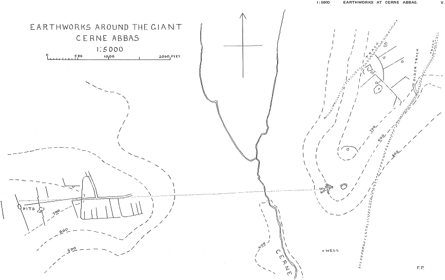
Turning now to Plate V, a general view of the region can be taken. The river Cerne runs down the middle of the plan, and the town is at the lower part of the plan. The well on the east is obviously the early centre of attraction; it is said that it was visited by Augustine, and that it cured many diseases. It was one of the sacred springs round which primitive religion centred. Though now its water flows through the town, a large graveyard lies all over the higher sides of the ground, and must contaminate the water. Directly north of the well is the Giant, with the enclosure of the maypole above his head. Further back along the ridge is a tumulus, and a bank with curved ends, cutting across the ridge, perhaps to isolate the religious enclosure. {11} Further to the north is a group of banks and ditches. The main bank seems intended to cut off direct access to the end of the ridge. On the western side of the river valley is a ridge with another group of banks. There is an axial road, and a road branching from that to the north. Further west are large banks running across the hill at 700 feet, and two of these have deep pits, or shafts, in the line of the bank. As no one would lay out a bank thus, it appears that these pits were for flint mines, sunk jointly by two adjoining field-holders. This gives a probable age for this group of banks, when flint-work was still so important that pits were sunk to get a good supply.
The westernmost banks have an axis line, roughly at right angles; from this part, the Giant is not conspicuous, but on coming to the roadway descending a slope, a bend was made, and the axis points exactly to the Giant. The dotted line is put in the plan here to show the bearing, in relation to the banks. Lower down, the slope becomes much steeper, and it needs care in descending; here the road loses the direction, and turns askew from the line to the Giant. Thus, just where the gentle slope gave a natural sighting far ahead, the Giant was used as a fore-sight in laying out the road.
Now we have seen that the age of this group is within the period of flint mining, probably not after the early Bronze Age. The Giant must in that case be at least as old as the beginning of the Bronze Age.
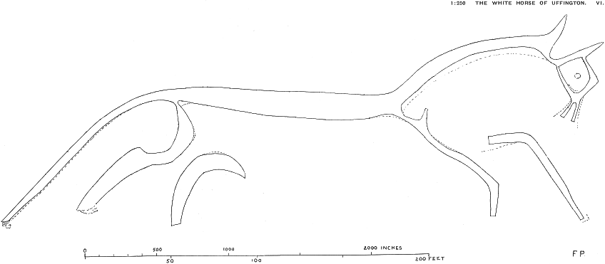
The figure of the horse, in Plate VI, differs from the human figures, as the whole area of it is cleared of turf, so that it appears entirely in solid white chalk. It is placed high up on the face of the chalk escarpment, three-quarters of a mile south-south-east of Woolstone Church, or 12/3 miles south of Uffington Church; lat. 51° 34′ 39″, long. 1° 33′ 55″ west. The figure is at 500 feet over the plain, slightly sloping up toward the head. The cliff faces to the west-north-west. General attention to the figure has always been kept up, and it was said to have been cleaned every seven years; thirteen scourings at least are recorded in 102 years down to 1857. Since then, the festival has decayed, and it has only been cleaned in 1884. This frequent scraping has probably led to some trimming, and the severed forms of two of the legs are probably due to changes of turf growth. In Plate VI there are broken lines, marking ancient hollows in the turf, which suggest a rather different outline. In former times, the neck was much thicker, the jaws much wider, the foremost leg came nearer to the {12} other, the hind legs and tail were slightly different. These changes suggest that others may have occurred, and the present state points to the space between the ears having been extended into the head, the eye greatly enlarged, and the haunch of one hind leg entirely obliterated. The projection on the foreleg marks where the neck originally started.
In our survey of this figure, the outline was measured at 178 points, by the same method as the other plans. After it was done, I compared it with a copy of a plan in the Ashmolean Museum, lent by the kindness of Mr. Thurlow Leeds, and in a few details of the head, where differences occurred, I verified on the spot that the present plan is the more correct.
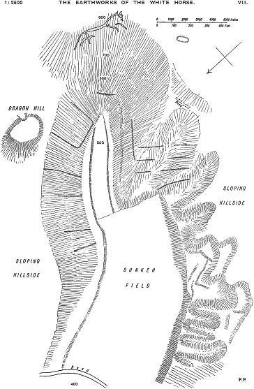
The earthworks subsidiary to the White Horse are here planned (Plate VII) for the first time. The Horse is placed at the top of a very steep gulch in the face of the down, which heads a valley running through the sloping plateau at the foot of the down. This remarkable form of the chalk was probably due to a water-fall and ravine caused by drainage of the chalk plateau in its early denudation. The slope below the Horse is in part 35½° or 100 feet fall in 140 horizontal, and from the Horse to the foot of the gulch is 300 feet in 660, or over 24°. All of these slopes are of course uncultivated, and not even grazed. Points at 400 to 800 feet are marked here. The bottom of the ravine below is ploughed in the wider part, and has formerly been ploughed in the narrow tongue leading to the foot of the slope. Along the western side of the wider field, the flank of the rising ground has been much cut up, artificially. Seven trenches have been cut back, but whether the ridges between them are natural, or piled earth, cannot be settled without excavation. Nearer to the Horse, the very steep spur above the tongue of field has four narrow banks across the west side, and two banks on the north side. The slope is such that it is difficult to hold on, and any cultivation would be out of the question. The purpose of such banks must be ceremonial rather than agricultural. Opposite to these, on the other side of the tongue of field, the steep slope down from the northern field has six slight banks running from top to bottom. Here, again, the slope is far too steep for cultivation. North of all the other works, there is the so-called Dragon Hill. This is a natural hillock, which has been cut flat on the top, and perhaps trimmed around the sides; a modern chalk-pit cuts into it on the east. The Ordnance Map states “Roman coins found” there. The whole of these earthworks need careful excavation, to clear up their character and meaning.
{13} In The White Horses, by the Rev. W. C. Plenderleath, is mentioned a cartulary of Abingdon Abbey naming White Horse Hill in 1084 or earlier, and again another cartulary of about 1190, naming the “ascent to the White Horse”. These are the earliest of several references to the name. The continuance of a festival here, and the rolling of a cheese down the steep into the field below—commonly called the Manger—seem clearly the remains of a religious veneration, and the fine springs that rise just below may also have been regarded, like the spring below the hill of the Cerne Giant. In connection with the Horse and the Giant, the account sent to me by a correspondent is applicable. “At Cooper’s Hill near Cranham, Gloucestershire, there is a maypole on a hill-top. The festival is held on Whit-Monday. The leader of the games wears a white loose garment and a tall hat decked with floating ribbons. The special race is for a cheese rolled down the steep and rugged side of the hill. It is such a hill as one would call a ‘pen’.” Cranham is five miles south-east of Gloucester; Cooper’s Hill is a large camp.
This cross, on a sloping pedestal, is entirely cleared of turf, exposing white chalk all over. It is on a very steep escarpment, facing west, one mile east-north-east of Prince’s Risborough Church, lat. 51° 43′ 42″, long. 0° 48′ 40″ west. The slope at the base does not attract attention as it is accommodated to the line of contour and road below. The stem width is rendered uncertain by a double edge of turf.
Above the cross, on the crest of the hill, is a barrow with a ditch around it. Excavation in it has left a large gap on the east side. It is clearly not in the axis of the cross. The relative position to the cross was paced, correct to one or two per cent.
This cross is high up on the escarpment, moderately sloping to the north-west. It is three-quarters of a mile east of Chinnor Church, and 3¾ miles west-south-west of the Whiteleaf Cross, lat. 51° 42′ 1″, long. 0° 53′ 12″ W. It is much more regular than the Whiteleaf Cross, and the drawings here are correct to 1/200th of an inch, or about the uncertainty of definition of the turf-edge, a couple of inches on the ground.
The regularity of this cross suggests that some definite measurement was used in setting it out. On comparing the dimensions, it is plain that the arms are twice as {14} long as their breadth. Hence the total width is five breadths. The outgrowing of the turf-edge, and the cutting back of it, tend to vary the widths; but the lengths of the arms should be similarly affected at each end of the measure, and therefore less variable. It is best, therefore, to keep lengths and widths separate in discussing the measurements. The mean value of the width unit is 170·5, mean difference 4·9; probable error 1·4; the length unit is 180·0, m.d. 5·7, ± 2·2. The stem is so much shorter than the other three branches that it is not included.
As the Whiteleaf Cross much resembles it, the measures of that were next compared. The lengths and widths of the arms are all similar to the Bledlow Cross. The stem is wider, but proves to be 5/3 of the other arms. This gives further information, that the 170 inch length is of 3 units. The means, by widths, average 174·0, m.d. 7·5, ± 2·3; by lengths 170·0, m.d. 4·6, ± 1·4. For a general mean, we may take that
| by the widths 172·2 ± 2·0, ÷ 3 | 57·4; |
| by the lengths, 175·0 ± 4·0, | 58·3. |
We have already noted that the Wilmington Long Man is based on a length of 1,392 inches; and this is 24 × 58·0, which is a reasonable link between the two figures. Taking this length of 58 inches as the unit, the Bledlow Cross arms are 3 wide, 6 long, total width 15 units; the Whiteleaf Cross arms are 3 wide, 6 long, stem 5 wide, total width 17; stem 9 long, total height 18 units. The total length of the base is 80 units, being 4 × 1,158 inches. This last is the diameter of the main circle of Stonehenge. It seems, thus, that there is a probability of a common measure in the Crosses, the Long Man, and Stonehenge.
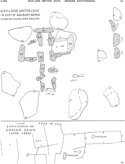
Though not connected with any of the previous works, two plans of early remains are here selected Plate IX, from among various plans done at the same time. Wayland Smith’s Cave is the well-known structure of a long barrow, and though it has often been planned, the plate here is perhaps more accurate than some others as the measures were all taken from cross lines to the nearest inch. The inclination of stones is shown by the levels on the tops, the upright stones are shaded, the buried parts are dotted. In detail, A is measured at the base, but leans with apex over south-west corner. B lies against A, resting on small stones. C capstone is over the slope of B. D measured at base, leans much inwards, probably 8 inches further out originally. E is tipped inward, probably 8 inches to north originally. F is tipped toward the north, the buried base is dotted.
{15} The earthworks at Smacam Down are unusual, as giving banks in connection with a long tumulus and a round tumulus. Some dimensions are so closely connected that measurement seems likely in the planning. A, E, are 1,880 inches, and half of D 3,560; B C 6,050, 6,090 are double of G 3,040; H and J are 2,750 and 2,690. These may all be connected in the proportion A 12, B C 40, D 24, E 12, F 15, G 20, H J 18, of an average unit of 151·7 inches, with a mean difference of 1·9 inches.
After reviewing these plans, we may try to see if any conclusions can be drawn from them. The differences in style prevent our assuming that the figures were all made by the same people at the same period, yet they might be related.
It seems impossible that nude figures should have been cut in the mediaeval age; nor is it more likely in Danish or Saxon times, as the immigrants were from cold countries and were always well clad. Certainly there is no sign of Romano-British influence. When we look to pre-Roman peoples, there are no parallels to these figures among the Gaulish or Celtic deities, or on British coinage. The horse is sometimes compared with that on the coins, but the latter is always a short, tubby beast, and not attenuated at long gallop like the Uffington monster.
It has naturally been supposed that the Crosses are of Christian origin. This is not at all certain, for the Greek cross is not used in Western Christianity. Further, the pyramidal base seems unknown; Byzantine coins from the sixth to the thirteenth century often bear the cross on steps, but never above a slope. If the Whiteleaf Cross had been of such origin, it would have been as easy to cut steps as to cut a slope on the hill. The Greek cross is known to have been a sacred object during the Bronze Age in Crete; so its presence here is quite as likely to be pre-Christian as not.
The evidence of the unit of measure of the Crosses being also applicable to the Long Man, is likewise open to two explanations. The unit of 58·0 inches in the hill figures is 5 feet of 11·60; this was an old Etruscan measure kept up by the Romans as 11·61; the provincial Roman form was 11·64 and 11·68; the diameter of Stonehenge is 11·68 inchesRead 1168 inches, i.e. 100 times this foot.. This foot is 16 of the widely spread digit measure, which was the basis of Egyptian and Greek measures; the foot is found both in early Greece and Etruria. It might, then, be equally used in the Bronze Age or under Roman influence.
There remains the evidence drawn from the prehistoric field settlement west of Cerne, that a road there was as old as the early Bronze Age, and was laid out pointing to the Giant. As there is no parallel to such human figures in Celtic mythology which {16} arrived here in the sixth century b.c., the figures are presumably of the Bronze Age; so the way is open for accepting the evidence of the Cerne road. The unit of measure, though not decisive, is also consonant with the early Bronze Age.
If, then, the figures may be deities of the Bronze Age, to what source can we look? The idea of the maypole, associated with the Cerne Giant, is widely spread through Germany and eastward. To grant a pole to a community in Egypt (sixth dynasty) was to establish an independent religious centre not assessable to any other temple. In India “All kings plant a pole for the celebration of Indra’s worship” (Mahabharata, Chandra Roi, p. 173). That the Bronze workers came from the Rhine district seems accepted, and all along the line of the Rhine and Danube to the Euxine the worship of Mithra is found. On the other side of the Euxine, the worship of Mithra, Varuna, Indra, and the Nasatya twins was already known by 1200 b.c. If these had come westward with the Bronze migration, Varuna might be the origin of the Wilmington figure, which has already been supposed to be opening the gates of heaven; it looks to the north, the region of Varuna; the figure was in shadow at sunrise and setting during ten months of the year, and Varuna was the god of the ten months of gestation. Lehman strongly holds the pre-Roman introduction of Eastern deities along the Rhine.
A modern Indian parallel to such large earth-figures I owe to Mr. Krishniengar. He states that a figure about sixty feet high is drawn on the ground, with white outline, and filled in with red; the attitude is like that of the Cerne Giant, but it bears sword and shield. This represents a demon of darkness, Andhaka, who is destroyed by Siva in a moonlight festival. As the Indian demons are the Persian gods, and vice versa, this would accord with Western Aryans representing deities on a large scale in this manner.
All that we can say at present is that the way lies open historically to a connection between the Aryan gods and the West during the Bronze Age, and there would be no impossibility in such gods being the origin of the hill figures. The importance of the horse in the Aryan worships would also accord with such a possibility. This view may help in the recognition of other pieces of evidence, which may substantiate it or refute it. Half the difficulty of research is to know what to recognize, and how it can be applied.