CELTIC BRITAIN FROM THE AIR.
GHOSTS OF ANCIENT FIELDS.
TRACING THE MAP OF 2,000 YEARS AGO.
NEW LIGHT ON ARCHÆOLOGY.
(By O. G .S. Crawford, F.S.A.)
(Archæology Officer, Ordnance Survey.)
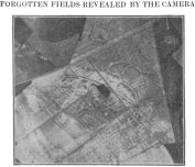
Sensational revelations do not often appeal to archæologists. But when an Air Force friend showed me some photographs taken for practice near Winchester I realised instantly that they marked the beginning of a new epoch in archæology. My friend had noticed upon them certain strange markings. On ploughed land they appeared as bands of lighter coloured soil, forming a pattern of irregular squares and rectangles.
These, to cut a long story short, proved to be ancient British “lynchets,” or field boundaries, which were formed during the Roman occupation and perhaps for some centuries before. The system of agriculture was entirely different from that which obtains today, which is directly descended, with modifications, from the early Saxon system. The Celtic system revealed by the air photos was a network of small patches, rarely more than two or three acres in size. Between some of them ran roads and boundary ditches, clearly visible as dark streaks on the air photos (dark, because of the deeper soil which has accumulated in the almost silted-up ditch). In many cases there could be seen close by, upon the same downland, the mounds and hollows of the village where lived the cultivators. Several of these villages have been scientifically excavated and their age thus determined. Many of them were certainly in existence two or three centuries before the Romans came; but as the people went on living in them throughout the Roman occupation, only the slightest traces of their first occupants have survived. The Roman conquest did not alter the peaceful current of their lives.
THE SAXON INVASION.
The Saxon invasions were far different. The savage hordes burnt and pillaged. They destroyed the upland Celtic villages. And when at last the Saxons settled down they founded new villages along the fertile river valleys. They brought with them from Germany a system of strip-cultivation radically different from the older Celtic system. This is well seen on air photographs, for it has only quite recently gone out of use, and the larger boundaries survive in many places as banks and hedges. Further, they harnessed the streams and made water-mills to grind their corn. They were the first to utilise our now neglected water-power resources. The clearance of valley forests (to which Dr. Evans refers in your issue of June 15) was begun by the first settlers in them—the Saxons. There is no evidence for any earlier system of valley settlements. We know where the Celtic villages were; they were on the downs, where they can still be seen. Occasional Roman “villas” may have been built in the lowlands; but of extensive or systematic forest clearing there is no evidence. Nor, seeing that the villages were on the uplands, should we expect it to be otherwise.
NEOLITHIC WORKS?
The air-photos depicted the pre-Roman hill-top camps literally in a new light, their grassy ramparts thrown into relief by sunlight and shadow. (One such picture is better than the most carefully-drawn hachured plan, for it is almost the thing itself.) But they revealed something much more exciting than this, for one could detect a faint inner ring within the outer ramparts of two of the camps. This inner ring appears to be unconnected with the rest and to be older than it. The ring inside Scratchbury (imperfect, but perhaps once complete) had been noticed but not commented on before; that inside Yarnbury had never been noticed until it was seen on the air photo, so faint is it. Are these small inner banks the vestiges of older—perhaps Neolithic—works, already ancient when the big outer camps were made?
We know that most of these bigger camps were constructed in the Prehistoric Iron Age, before the Romans came. But we know little or nothing of the settlements of the people in the preceding Bronze Age, or of the still earlier Neolithic Age. We know something about their tools and pottery from the remains found in barrows and burial places of the dead; but of the living there is hardly a trace. Most of these earlier habitation-sites were probably obliterated by the Celtic villagers who cultivated the uplands so extensively. The earliest earthworks—except the barrows—have nearly all been obliterated, and, in any case, so very few of the period have been properly excavated that we can only date a few with any certainty. No one can date a camp by merely looking at it; only scientific excavation can do this. Such excavation has revealed a most remarkable unique Neolithic earthwork; but it is premature to describe this yet. It is going to be photographed on the next cloudless day.
POSSIBILITIES OF AIR PHOTOGRAPHY.
Air photography for archæological purposes is still very much in its infancy. We hardly know the best conditions for getting good results. One surprising feature—and a very satisfactory one—is the way in which earthworks show up on ploughed land. It is just there that we find field-work on the ground so perplexing. The bank, or ditch, or barrow, or Roman road which has been ploughed nearly flat is often visible from a great height as a broad band of darker or lighter soil. Mere proximity makes this broad band invisible from the ground, just as rocks below the sea can be seen only from a cliff or a seaplane. At first—even in the days before aeroplanes—we thought that photos taken from above would show up the faint earthworks on the grass downs by means of the faint shadows cast at sunrise or sunset. That may yet be under favourable conditions. But they must be photographed very early or very late to get the full effect of shadow, and it is just there that the weaker light makes photography most difficult. Unlimited experiments are naturally impossible; but a good deal can be done by comparison of such photos as have already been taken under different conditions. One thing is now clear—over arable fields the late spring or early summer is best, if it be dry. When wet, chalk becomes grey instead of white; so the earthworks which are being ploughed over do not show up nearly so well. The fact of their showing at all is due to the presence of minute grains or small lumps of chalk in the darker soil. This makes visible the characteristic white band on the air-photo. The height is not so important; 6,000 feet gives good average results.
I must correct a small error in Major Turner’s very kind notice which appeared in your issue of June 10. I have not taken any of these photographs myself. They were made in the ordinary routine of practice by members of the Royal Air Force, whose keen interest in the results has made these archæological applications possible.
In connection with the article in the preceding column, we publish two photographs taken from the air. Of these, the first shows, in the fainter lines, the outlines of ancient British fields as divided during, or before, the Roman occupation. These markings are quite invisible from the ground, but in photographs taken from the air the boundaries are clearly indicated.
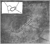
In the case of the second illustration, which is of Quarley Camp, Hants, both camp and ditch are visible on the ground, but the relationship between the two is made clear by the air photograph, which shows that the ditch was there when the camp was made. The camp, as a matter of fact, cuts through the ditch.

