{Inside front cover}
Adventure lies lurking in these lines where I point the way for younger feet than mine.
Detective work of sorts. Unnoticed mark-stones buried in the banks of cross-roads, in the field, or on a town pavement; the edges of an unrecorded camp; a faint mound almost levelled; or, again on the lay of the land, as the eye looks straight on, the point of a distant beacon-hill as a mark on the sky-line.
Who will strike the trail?
A. W.
{Inside back cover}
BOOKS
by
ALFRED WATKINS, F.R.P.S.
All fully illustrated with photographs, maps or diagrams.
| EARLY BRITISH TRACKWAYS. | |
| Simpkin Marshall. | 4/6 |
| THE OLD STRAIGHT TRACK. | |
| Methuen. | 18/- |
| THE LEY HUNTER’S MANUAL. | |
| Simpkin Marshall. | 2/- |
| PHOTOGRAPHY. THE WATKINS MANUAL. Eleventh edition. | |
| Simpkin Marshall. | 1/3 |
| PHOTOGRAPHY, ITS PRINCIPLES AND APPLICATIONS. Third edition. | |
| Constable. | 12/6 |
| THE OLD STANDING CROSSES OF HEREFORDSHIRE. | |
| Simpkin Marshall. | 10/- |
{1}
ARCHAIC TRACKS
ROUND CAMBRIDGE.
{2}{Blank}
{3}
Archaic
Tracks
Round
Cambridge
Trade Agents:
SIMPKIN MARSHALL, Ltd.,
Stationers’ Hall Court, E.C.4.
{4}
hereford:
printed by the hereford times limited, hereford
1932.
{5}
| Page | ||
| INTRODUCTION | 9 | |
| CHAPTER I. | A BASIS FOR INVESTIGATION | 11 |
| CHAPTER II. | ACCIDENTAL COINCIDENCE | 15 |
| CHAPTER III. | CAMBRIDGE BOROUGH MAP | 16 |
| CHAPTER IV. | CAMBRIDGE DISTRICT MAP | 18 |
| CHAPTER V. | PRE-HISTORIC ORIGIN OF GREAT ROADS | 21 |
| CHAPTER VI. | SEASONAL ALINEMENTS | 27 |
| CHAPTER VII. | CARDINAL-POINT ALINEMENTS | 31 |
| CHAPTER VIII. | PLACE-NAMES | 41 |
| CHAPTER IX. | CONFIRMATION AND MORE TRACKS | 43 |
| CHAPTER X. | NOTES | 47 |
| APPENDIX A. | TABLE OF AZIMUTHS FOR CAMBRIDGE | 51 |
| APPENDIX B. | AZIMUTHS OF ALINEMENTS ON MAPS | 52 |
| INDEX | 55 |
{6}{Blank}
{7}
| Page | ||
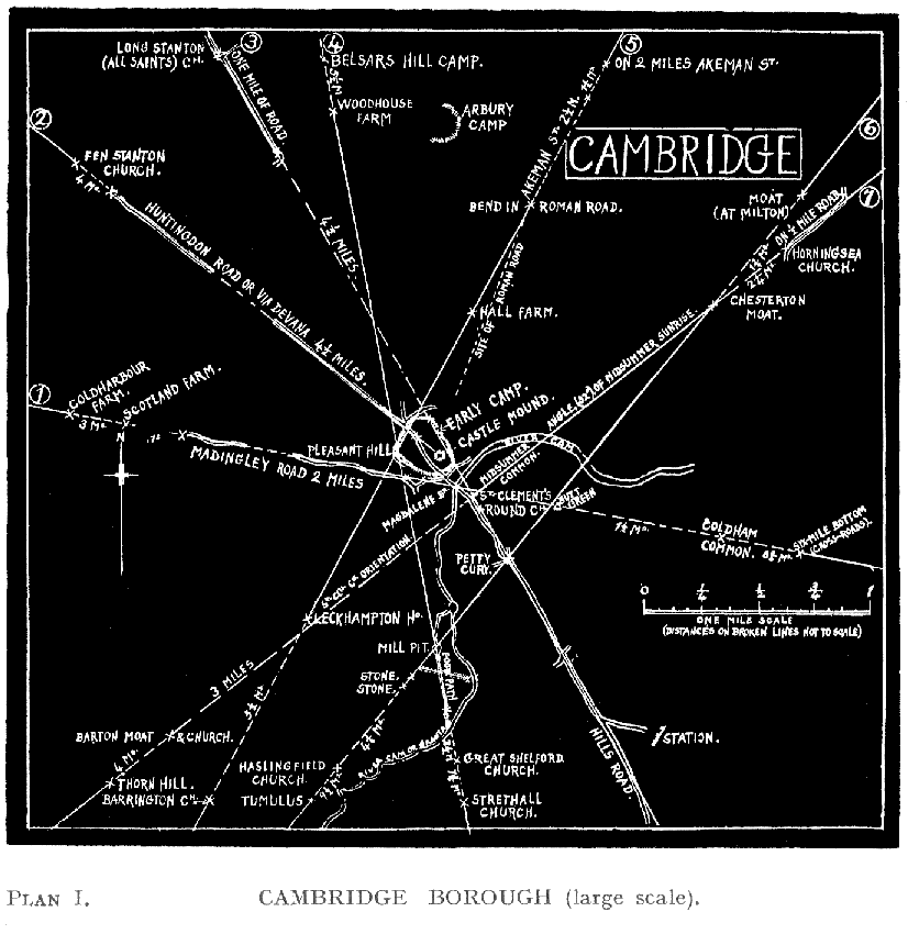
| PLAN I. | CAMBRIDGE BOROUGH MAP | 17 |
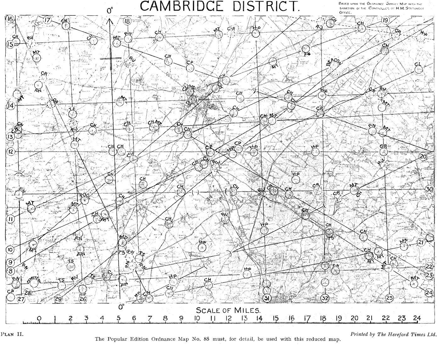
| PLAN II. | CAMBRIDGE DISTRICT MAP (Folding) facing | 18 |
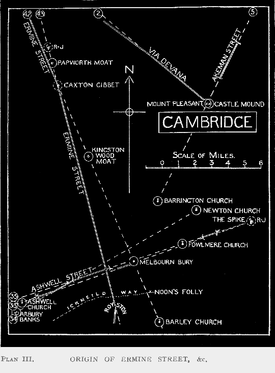
| PLAN III. | ORIGIN OF ERMINE, AKEMAN AND OTHER STREETS | 22 |
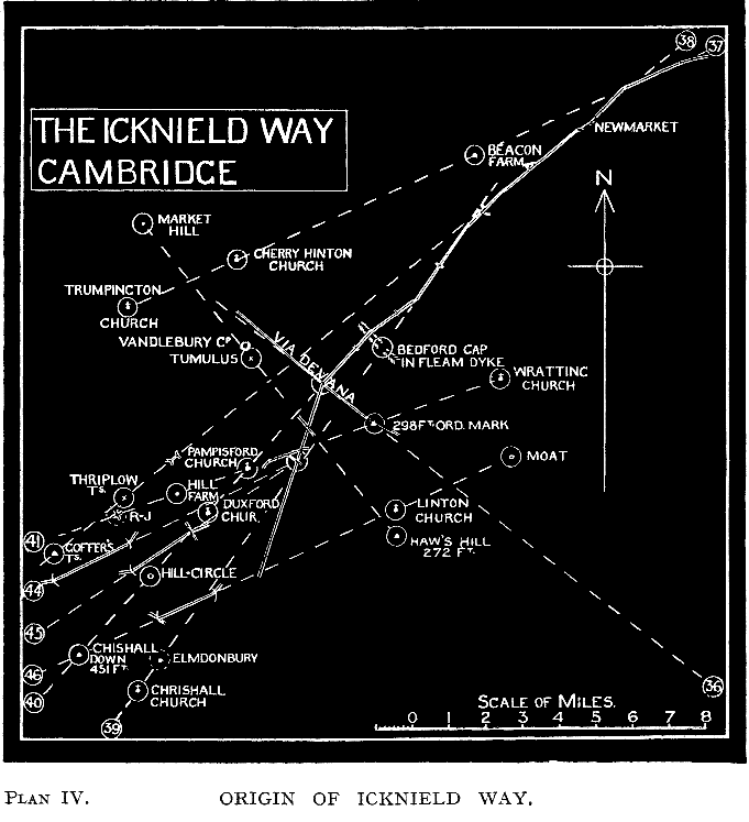
| PLAN IV. | ORIGIN OF ICKNIELD WAY | 23 |
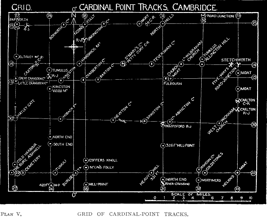
| PLAN V. | GRID OF CARDINAL-POINT ALINEMENTS | 32 |
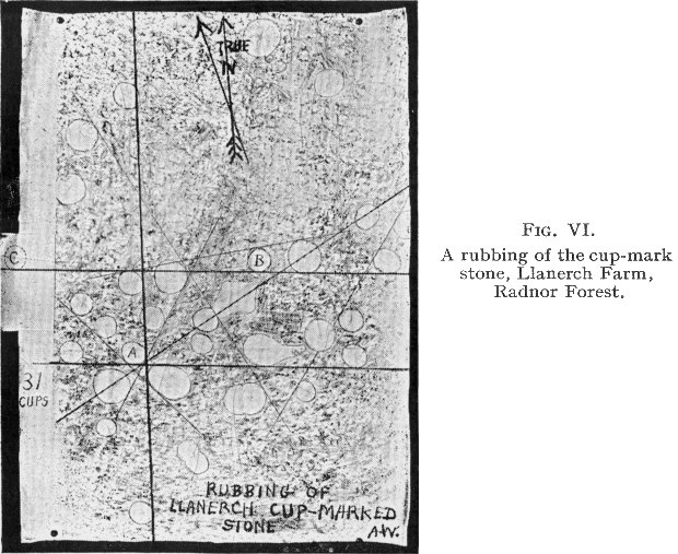
| FIG. VI. | RUBBING OF CUP-HOLLOWS, LLANERCH FARM, RADNOR | 37 |
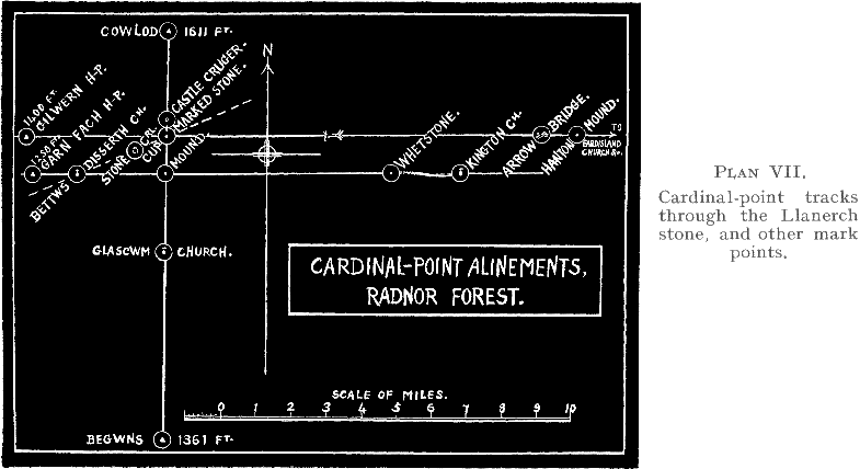
| PLAN VII. | CARDINAL-POINT ALINEMENTS, RADNOR FOREST | 31 |
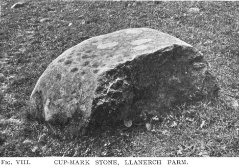
| FIG. VIII. | CUP-MARKED STONE, LLANERCH FARM | 39 |
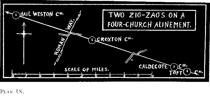
| PLAN IX. | TWO ZIG-ZAGS ON A FOUR-CHURCH ALINEMENT, CAMBRIDGE | 44 |
| TAIL-PIECE. | THE “LONG MAN OF WILMINGTON,” A PRE-HISTORIC SURVEYOR | 50 |
{8}
“To guide my course aright,
What mound or steady mere is offered to my sight.”
. . . . . . . . . . . . . . . . . . . . . . . . . . .
(Mountains and hills are declaiming)
“Besides, we are the marks, which looking from on high,
The traveller beholds; and with a cheerful eye
Doth thereby shape his course, and freshly doth pursue
The way which long before lay tedious in his view.”
Michael Drayton
(Polyolbion, Songs First and Seventh).
{9}
Herein is a framework for local and field investigation, a prima facie case, for of the two equally important branches of enquiry—map and field work—I offer the first only. I leave the field work to those who by health-giving tramps along the lines indicated, will, I feel sure, find new corroboration.
A flying visit to Cambridge, and a glance at local maps showed the district to be unusually rich in mark-point evidence, and two mornings scouting round Cambridge Castle gave the probable limits of the pre-Roman camp there.
I keep to evidence more than conclusions. Two questions naturally arise : “When was this done ?” and “What race of men did this skilled work?” I make no attempt to answer here.
The multiplicity of crossing tracks will clash with the preconceptions of most readers. But why not? In primitive days, when no property rights stood in the way, a path was easily started by the instinctive way of walking for a mark on the sky-line. “The number of the people is countless, and their dwellings exceedingly numerous,” testifies Cæsar. It is natural that tracks should be thicker on the ground than to-day.
With baited breath I suggest that the official attitude which allows the planning of a sighted track and its mounds, but limits the knowledge to one nation only—the Romans—is weak, in face of the records in the Old Testament. For there, five hundred years before Rome was a nation, it is clear that prophets and chroniclers were perfectly familiar with “Straight paths for your feet,” with all their attributes of “waymarks,” “high heaps,” “standards,” “beacons,” and “high places.” “Let your {10} eyes look straight on” was the instruction, and the tracks were even then “ancient paths” in danger of degenerating into “crooked ways.” The Romans learnt it all from earlier races, and so might well the Celtic races in Britain.
John Bunyan, too, who, as a tinker, travelled this very country, was quite sure about the “narrow way,” “as straight as a rule can make it, cast up by the patriarchs, the prophets, Christ and his apostles.” This from his beloved Bible, but the stone causeway through the morass he did not find there, but in his own native and watery land, with just such straight causeways as he pictures.
If the reader finds me packing too much detail in these covers, can he not just dip into it—as he would into a dictionary, for only that place, district or “lay of the land” in which he is interested ?
Lacking local knowledge, I shall make blunders, as accepting for mark-point a site not ancient. But if several examples are spoilt by such weakness, I must remind logical readers that half-a-dozen fully proved sighted tracks of pre-Roman date across country are sufficient for proof that such a system was here before the Romans came.
Before condemning any connection between archaic tracks and sun observation, consider the pertinent evidence I give in Chapter VI. of a Welsh word indicating that “a slight track or path” was habitually made by astronomers with the aid of light observation.
A. W.
5, Harley Court,
Hereford.