
Destruction of Germanic cult places • Lines in cardinal directions • Origin of cult places • Ritual fires later used as signals • Churches etc. on old sacred sites
A chance happening, constantly repeated, negates itself.
Adolf Bastian
In Mediterranean countries there was in antiquity an orientation of plots of land and sacred buildings. The survival of such buildings or their ruins has made scientific researches possible, such as Prof. Nissen of Bonn undertook at the beginning of this century on 350 temples, with a positive result [201.1].
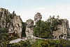 Externsteine
In Germania all sacred buildings of the pre-Christian era, insofar as they existed at all,
have vanished from the face of the earth, the sacellum of the Externsteine perhaps forming the sole exception.
Dr. Löschke in Trier [Treves] is now excavating the deeply buried remains of sacred buildings,
whose significance we have yet to assess.
Externsteine
In Germania all sacred buildings of the pre-Christian era, insofar as they existed at all,
have vanished from the face of the earth, the sacellum of the Externsteine perhaps forming the sole exception.
Dr. Löschke in Trier [Treves] is now excavating the deeply buried remains of sacred buildings,
whose significance we have yet to assess.
Splendid temples in the classical sense, people would scarcely have had; for they preferred to worship the deity in the grove or on mountain heights. Such roofed areas as were nevertheless felt necessary for religious purposes were generally wooden buildings which, even if they had not been destroyed on the introduction of Christianity, could only have lasted for a few hundred years.
But strewn across the country there were numerous other marks and towers, built from stone and dedicated to the service of the deity, which have also disappeared. Not only their existence, but also their total destruction, appears with shocking clarity from a little-known decision of a church council at Nantes, which the capitulary of Charlemagne at Aachen in 789 confirmed and made even more severe. I quote this decision from a work of Consistory Councillor Prof. Franz Widlak of Znaim [201.2], surely an innocuous source, and I place it verbatim here at the start, because it needs to be kept in mind from beginning to end of my discussion. It is the 20th canon of this obviously very fruitful church council, for which the already executed destruction of the marks was still not enough. It runs:
“Lapides quoque, quos in ruinosis locis et silvestribus daemonum ludificationibus decepti venerantur, ubi et vota vovent et deferunt, funditus effodiantur atque in tali loco proiciantur, ubi nunquam a cultoribus suis inveniri possint. Omnibusque interdicatur, ut nullus votum faciat aut candelam vel aliquod munus pro salute sua rogaturus alibi deferat, nisi ad ecclesiam Domino Deo suo.”
In English:
And let the stones, which people deluded by the trickery of demons worship in ruined and wooded places, where also they make and fulfil vows, be completely uprooted and thrown into such a place that they can never be bound by their devotees. And let it be forbidden to everyone to make a vow, or bring a candle or any kind of gift asking for his [soul’s] health, at any place other than the church and to the Lord his God.
Who can doubt, in view of the power of Rome and the fanaticism of those times, into which the people themselves were drawn more and more, that this decision was carried out to the letter?
An exception seems to have been made for the stone crosses
(“murder crosses”, “atonement crosses”,
Fig. 69),
which still exist in large numbers on Germanic territory.
 Fig. 69
They were preserved if only because of their cross-shape,
which was thought suitable for turning the Germanic custom into a Christian one.
This happened through Pope Leo III as early as 779, when he ordered that at crossroads where people
were accustomed to meet, wayside crosses should be set up [202.1].
This, however, because of their sinister original meaning and probably also because their shape was
not quite suitable, was not entirely a success. Again, the later attempt to make them into
memorial crosses,
and then set up new memorial crosses to match, did not take effect, so that Dr. Kuhfahl in his valuable work
Die alten Steinkreuze in Sachsen [the old stone crosses in Saxony] reaches the overall verdict:
“As regards the widespread finds of stone crosses, which I was able to count by the thousand
in central European territory between the Vosges and the western Caucasus,
between the plains of upper Italy and the northern shores,
we are still faced even today with a riddle.”
We shall have to regard it as an undeniable fact that the majority of old stone crosses
are of Germanic origin and are connected with the ancient belief.
The symbols that frequently occur on them could probably shed much more light. In our
lastRather, the next to last, No. 47
example
of orientation we shall encounter a stone cross which strengthens our hypothesis that moot-places
had such crosses as markers.
Fig. 69
They were preserved if only because of their cross-shape,
which was thought suitable for turning the Germanic custom into a Christian one.
This happened through Pope Leo III as early as 779, when he ordered that at crossroads where people
were accustomed to meet, wayside crosses should be set up [202.1].
This, however, because of their sinister original meaning and probably also because their shape was
not quite suitable, was not entirely a success. Again, the later attempt to make them into
memorial crosses,
and then set up new memorial crosses to match, did not take effect, so that Dr. Kuhfahl in his valuable work
Die alten Steinkreuze in Sachsen [the old stone crosses in Saxony] reaches the overall verdict:
“As regards the widespread finds of stone crosses, which I was able to count by the thousand
in central European territory between the Vosges and the western Caucasus,
between the plains of upper Italy and the northern shores,
we are still faced even today with a riddle.”
We shall have to regard it as an undeniable fact that the majority of old stone crosses
are of Germanic origin and are connected with the ancient belief.
The symbols that frequently occur on them could probably shed much more light. In our
lastRather, the next to last, No. 47
example
of orientation we shall encounter a stone cross which strengthens our hypothesis that moot-places
had such crosses as markers.
If it was considered necessary at Nantes to take the above-quoted decision about sacred stone buildings set up in woods, how much more are we forced to assume that in towns and villages any temples and other sacred buildings were one and all destroyed with the utmost thoroughness. A similar church decree affecting the Mediterranean countries is not known, and if it was issued it was at all events not carried out, as shown by the temple ruins that still exist; probably because the weak religious commitment of the Mediterranean peoples made such a measure seem unnecessary. But in Germania things did not stop at the physical destruction of the temples, but went so far that at every opportunity – and moreover with success – the veil of oblivion was drawn over such happenings. Thus from the biographies of Charlemagne, for example, one has to seek out for oneself, with some difficulty, the brief references to acts of destruction, just as indeed his massacre of the Saxons at Verden is also dismissed in a few lines.
From ignorance or disregard of this momentous event, namely the destruction of buildings during the conversion period, there might arise among the German people the disastrous fallacy that, from a complete absence of notable buildings or their remains, one can and must infer the low state of Germanic architecture and thus also of the whole culture at that time.
As regards the existence of an astronomical orientation in pre-Christian Germania, I have not been able to find any
kind of discussion in our literature,
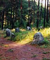 Odry circles
except that Engineer Stephan of Halle-an-der-Saale discusses the fixing of the sun’s position
at the summer solstice in Stonehenge and the fixing of star positions in the
stone layout in the Tuchola Forest [203.a].
Here I should particularly like to draw attention to Stephan’s work in the volumes of Mannus.
Recently there have been added the discussions by Werner Timm et al.
on the “Steintanz” [stone dance] in Mecklenburg [203.b].
General Schradin of Ulm, in a manuscript study,
draws attention to the orientation observed by him in Lothringen and southern Germany.
In the periodical Das Weltall [203.1] Prof. Dittrich brings together a rich
collection of reports and ideas on astronomical tendencies in general, and on orientation and its probability
in particular.
Odry circles
except that Engineer Stephan of Halle-an-der-Saale discusses the fixing of the sun’s position
at the summer solstice in Stonehenge and the fixing of star positions in the
stone layout in the Tuchola Forest [203.a].
Here I should particularly like to draw attention to Stephan’s work in the volumes of Mannus.
Recently there have been added the discussions by Werner Timm et al.
on the “Steintanz” [stone dance] in Mecklenburg [203.b].
General Schradin of Ulm, in a manuscript study,
draws attention to the orientation observed by him in Lothringen and southern Germany.
In the periodical Das Weltall [203.1] Prof. Dittrich brings together a rich
collection of reports and ideas on astronomical tendencies in general, and on orientation and its probability
in particular.
Further, the orientation of the long axis of Christian buildings on the west–east line, practised from ancient times, had rightly led some people to ask whether this, like countless other Christian customs, was not to be referred back to a usage common in Germania; for obviously alignment on the holy places in Palestine would in Germanic countries have resulted in a south-eastern and not an eastern direction. The true eastward placing could well have a foundation in Germanic star-worship, but not in the Christian religion.
My search, stimulated by observations at the Externsteine and at Oesterholz, for any surviving vestiges and indications of an orientation in Germania has had a positive result. They led to the proposition:
Over wide areas of Germania there was practised the custom, based on astronomical observations, of a northward and eastward siting of sacred buildings and other public places in relation to one another. Also, alignments on the direction of the solstice and other orientations can be proved.
The last surviving trace of the custom will enable us to find out the sites of former sanctuaries, after which, with the methods available to archaeology, it will be possible to undertake further researches.
The Externsteine and Oesterholz had already shown that the ancients provided themselves with sighting points for their astronomical lines in their natural surroundings. But my further investigations at first came across only isolated, and thus inconclusive, orientations on the extreme positions of the sun and moon.
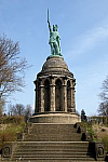 Hermann
Memorial
Even the striking fact that the meridian-indicating
boundary line of the estate at Oesterholz, after crossing a mountain ridge, intersected the ruins
of the Teutoburg near the Hermann Memorial, and further to the north hit firstly an enigmatic
stump of a tower on the Hiddeser Berg and then the chapel site in Heidenoldendorf,
was not enough, but kept interest alive.
The incentive for further painstaking research, rewarded this time with surprising success, came from visit to the old Germanic camp “Dehmerburg” (still not marked on our maps) on the southern slope of the Wittekindberg in the neighbourhood of Porta Westfalica. At the “Wilder Schmied” inn, I observed that the lookout tower, which rises above the camp, and on whose site the watchtower of the camp will have been, stands north of the Hermann Memorial with a deviation from the astronomical north line of some 0.8 to 1.0 degrees, according to which point on the Grotenburg is taken. The distance between the Teutoburg Forest and the Weser Hills is here 37 km.
Then I also became aware of (2) the west–east (equinoctial) line passing through the Teutoburg, sharply defined in the east by another lookout tower, Kalenberg, which rises above the well-known old Schiederburg castle (Altschieder). This time the deviation from the astronomical direction was so small as to be scarcely measurable, even with a large protractor 30 cm in diameter. Near the middle of the 23-km stretch, a suitable site for an intermediate station, I was astonished to encounter once again the Meinberg lookout tower, which is already known to us as a sighting point for the lunar line at the Externsteine. And west of the Teutoburg on this line rises the church of Stukenbrok. Thus I was faced with the remarkable fact that at the Teutoburg both the north line and the east line, directions that were already conspicuous at Oesterholz, had on the skyline of the mountains an endpoint very strongly marked by a lookout tower, and that under the lookout tower in both cases there was an old camp!
Now phenomena such as these two Teutoburg lines, if they occur in isolation, can indeed be put down to a remarkable coincidence. For of course every fairly long line drawn across a map hits all kinds of points, among them probably one or even several that are of some archaeological significance. But belief in a coincidence, or the possibility of a coincidence, must eventually come to an end, if the same phenomena mount up with our system of north and east lines, yet seldom occur with another system chosen at random and applied in the same way.
Then, as investigation of a larger number of the remaining old camps and castles in Lower Saxony had a more or less impressive result, there grew up gradually before my eyes and those of my co-workers the picture of an orientation of ancient sites, which whilst naturally defective throughout and obscured in many details, yet even now is still enough to convince, although for the last 1150 years only destructive forces have been at work on it.
Along with the considerable number of lines similar to the two mentioned above, there then appeared a very large number of shorter, easily overlooked, and therefore to many people even more impressive orientations, with their local importance for the religious life and for the calendar of those living nearby.
According to everything that we know of the religious life and the customs of the ancient civilizations, the cardinal directions played an important role. In the German Museum in Munich can be seen a picture of the Egyptian king and the goddess of wisdom setting up ranging poles for the north–south axis at the founding of the temple of Amada in 1475 B.C.
Because of the presence of northward orientation, which was deeply rooted in the old Germanic religion, whereas in the field of Christian thought and feeling it is quite out of the question, the ground is cut away from any notion that the orientation phenomena could still have arisen in the Christian era. “Towards the north lay the Devil’s dwelling, and recent converts had to renounce the old religion with scowling brow and scornful gestures directed northwards [205.1].” With this the relation of the Christian church on the one hand, and the Germanic religion on the other hand, to northward orientation may be sufficiently characterized. Thus it comes about that our observations often display, as chief points of the orientation, just those points that have nothing to do with church and Christendom.
The northward direction has furthermore had an influence reaching deeply into people’s way of life throughout the world. To this day the habit is kept up among the Indians of placing the body in a northward position to sleep; in the Wupper valley, if someone cannot sleep he is likely to be given the good advice to turn himself towards the north.
The tendency to orientation is probably to be traced back to the earliest awakening of religion and culture. In practice people will have begun by using markpoints of the natural surroundings, as seen from certain places, to memorize and fix more and more carefully the directions on the horizon in which the sun rose or set at defined important times. In this way an aid was acquired for the division of the year, which with the beginning of agriculture had become one of the most important practical questions in life. In coastal areas there was added the pressing need of navigation. Again, cattle-breeding, hunting, and fishing required observation of the calendar.
Intimately linked to orientation from the first, and indeed to be seen as the basis of the whole tendency, was the need of religious feeling to turn oneself toward the direction where the deity to be worshipped was imagined to dwell. The more a set of customs was developed for sacrifice and prayer, for vows, oaths, and other solemn acts, the more important the cardinal directions must have become. And the more godfearing somebody was, the more attention they must have given to orientation.
It is in this religious diligence, linked with concern for the calendar, that the origin of “scientific” astronomy is to be discovered. It must be called scientific for this reason, that with the least possible competition from emotions or wishes it was seriously concerned with ascertaining the actual relations of the heavenly bodies, and had to think out its own way to reach this goal.
And indeed the result was an altogether creditable one. The polar axis was identified so precisely that it cannot be distinguished from the polar axis of modern astronomy. Astronomers judge that a lay person of our own time, though equipped with watch and compass, would be hard pressed to carry out this non-trivial task as accurately as the ancients, to our admiration, have done. Observational errors too, which must naturally be reckoned with in all practical cases, and on account of which expert opinion allows a tolerance of one degree or more, were seemingly with the ancients very slight. A leeway of one degree is therefore only to be allowed in very rare cases, and when supported by other reasons, – always with the present polar axis taken as a basis. Of course, it is still possible, indeed probable, that the ancients very often measured less accurately. In the oldest Christian period, when Germanic astronomy was suppressed and forgotten, the orientation of churches was mismeasured by up to 14 degrees.
As regards the difficulty of determining the polar axis, let us also remark that a few thousand years ago the present pole star was a long way from the pole, and another usable pole star was not available.
The next obvious, psychologically inevitable stage of development was the raising of orientation places marked by natural features into sanctuaries, for spirit of the deity hovered round them. As a result their furnishings were related to what people needed when they assembled at this consecrated spot on festival days of its deity. What these furnishings consisted of, we can only guess: perhaps a marker of wood or stone (menhir), a raised platform, a cairn, or a raised holder for fuel, so that the fire might blaze up high.
Yes, fire, this truly supreme and favoured means of worshipping the gods! There was a ritual arousing of the flame by rubbing wood, for which the name needfire (notfeuer, nodfyr) is known from early times. The Indiculus forbids “illos sacrileges ignes quos niedfyr vocant” – those sacrilegious fires that they call niedfyr. We have abundant knowledge of the Easter and St. John’s fires.
That in orientation points we are in fact dealing with the sites of hill and woodland sanctuaries, of whose existence we were already aware but whose locations we did not know, with places at which people came together, is clear from the busy access routes that have frequently been preserved until our own time; for the nature and use of the places in later times often provides no good reason for the star of roads that already meet there.
Sometimes, namely where the nature of the ground was suitable for agriculture and settlement, these enclosed sanctuaries and the dwelling-places of their first inhabitants – fire-wardens and, from the metal age onwards, also smiths – became the nuclei for subsequent villages. In such cases the sanctuary on the orientation system became the village moot-place. The further we take our hypothesis about the origin of orientation back into the earliest settlement times, the more intelligible the whole phenomenon becomes.
Not a few of the villages that arose in this way show by their street plan – as of course do other villages with a moot-place or church – that the roads meeting at this spot had to skirt round an enclosure. To the modern motorist hurrying through such villages, the church sites seem to be traffic blocks placed across the road.
As regards these oldest church-villages, one of the most certain facts of our Germanic history is that churches in the conversion period, in accordance with an edict of the contemporary popes, were sited if possible on the moot-places “where the people are accustomed to assemble”. It was an edict for abolishing the old religion that was as cruel as it was effective, the more so as desecration of the church was made a capital offence.
Nevertheless, because of the frequent occurrence of churches in some regions, we shall not be justified in submitting them as evidence unless a line seems to be already established by other means, or its orientation over a short distance is a very impressive one.
Once the orientation points had come into use as places of assembly for festivals, there existed for them in turn a need for orientation, and this in the same direction in which they themselves had been fixed on the line. This is a simple explanation for the development of the longer lines, which sometimes pass for a considerable distance over hill and valley, and on which – for us, of course, with gaps – the stations appear like pearls on a thread (see Example 31). It is noticeable and understandable that on most of these longer lines the errors of observation from one measured point to the next have almost cancelled out, so that the beginning and end points usually show only a slight difference from true east or north. For the errors would obviously not occur all on the same side.
The far-shining fires were now a ready-made means for the national leaders to communicate with people living at a distance. With the progressing needs of the community, a signalling system will have developed for peaceful and warlike purposes, which must have surpassed the signalling system found among the savages of Africa to the same extent that the Nordic peoples tower in intellect and other endowments over the coloured races of our own time.
The Germanic peoples in Roman times were startled out of a way of life that knew indeed of quarrels fought out as duels among the leading men and their followers [208.1], and bloody tribal brawls, and on the borders resistance to invading foreign peoples with their wives and children. But nothing was known of battle against a well-trained, foreign, hostile armed force. When this became necessary, around the turn of our era, the Germans braced themselves – in the years 15 and 16 even more than in 9 A.D. [208.a] – for military actions on such a scale and with such skilful management of large forces that these actions, brought before expert military judgement, must appear quite unanimously as evidence for an outstandingly efficient communication system. It was similar later on, in the 32 years during which Saxony fought against Charlemagne, who approached as a foreign conqueror and oppressor with his well-trained and already fully romanized Western Franks.
Such military achievements strongly suggest that the existing religious-calendric light stations were also exploited for the public communication system. Moreover, the thought is not to be dismissed that, in the midst of this confusion of countless fires shining in the land on every possible occasion, it was precisely the lines already determined astronomically, as they had developed though orientation, that allowed messages to be transmitted reliably as far as the national border. That this thought is correct, one can convince oneself by looking round at the Easter fires, e.g. in the region of the Meinberg lookout tower. It was only through astronomically-defined straight lines that disruptions and misunderstandings in the transmission of messages could be avoided.
At those places on mountain heights where the fires of the ancient people shone far and wide, we now find a striking number of our lookout towers. Moreover, these are not the ones whose sites were first sought out, cleared, and built on to satisfy the modern craving for delight in Nature, but the ones that since early times have had a special status, created or at least protected by human hands, as open spots visible from afar. The sites were then often used in the Middle Ages for military watchtowers, before being chosen in recent times for lookout towers or belvederes. The reason why their special status has (fortunately for us today) persisted in woodland is probably that the nature of the soil in these places, kept free of tree growth for thousands of years and prevented from forming humus, has resisted both natural plant growth and afforestation. If they have also retained their access routes, it means they offer every advantage for the construction of lookout towers.
For similar reasons, many a medieval lookout in town or country will have been built on the same spot where once the Germanic sanctuary stood. Rather than prepare a new site or even buy a privately owned one, it was natural to take one already available, which was in public possession and well suited to the purpose.
Apart from the above-mentioned churches on moot-places, which in many cases can be distinguished from the great number of other churches by mapwork alone, and apart from lookout towers and watchtowers, we have to take into consideration, as evidence of former orientation points, isolated woodland chapels, hermitages and small monasteries. We may assume their predecessors were erected almost invariably as early as the conversion period for expiation and purification on sites of the Germanic religion.
In Evangelical regions and those Catholic regions where wayside shrines and crosses seldom occur, these should also be counted in, especially if they are in out-of-the-way places. The oldest Calvaries arouse the greatest suspicion that they were built on the sites of important Germanic sanctuaries. Both these instances were strongly influenced by the attitude that the evil spirits of the old gods had to be driven away from such places: those gods who of course, according to the belief of early Christendom, were alive and continued their misdeeds at the accustomed places of their worship. The Way of the Cross leading to the Calvary north of Brakel is laid out on 130° and thus on the midsummer sun.
If sites could not be purified in this way, then the path of satanization was followed. They were called Devil’s and witches’ places, or given scornful names and brought into a bad repute that has frequently lasted to the present day.
We have further to consider the sites, mostly in outstandingly favourable positions, of supposedly medieval castle ruins and residential castles. There are strong reasons why we may consider many castles – pending a proof to the contrary, which would be difficult – as the successors and heirs of what the ancestors in the Germanic era made out of the sites. Similarly our oldest farmhouses naturally still lie exactly on the sites where the Germanic ancestors – back to the earliest times of agriculture – in the sweat of their brow won living space and useful land from the barren conditions of the Ice Age, and where they reared their dwellings, broad and stately as befitted the advancing culture [209.1]. The few castles and circular earthworks that were not built over later, which we still have available for investigation, still give us satisfactory teaching as to which places the ancients sought out for their purposes. And among these purposes the religious sanctuaries stand in the first rank.
Finally we must, with due caution, pay attention to all other kinds of buildings and structures placed on old public ground, and often lying at crossroads: such as schools, graveyards, even knackers’ yards, mills, and many others, when they turn up at places where for other reasons we have had occasion to look for orientation markers.
In the present state of research I can only give the orientation examples provisionally, without the improvement that is, in many respects at least, becoming necessary. But once orientation in Germania had become for me and my co-workers an indubitable fact, which is finding more and more confirmation and has already proved itself as a heuristic principle (method of discovery) [210.1], it became necessary to lay the case before the public, for only in this way are further clarification, exploitation, and progress made possible.
My proviso is necessary because of the difficulties we face at present. We have to deal with not only the assessment of the observational errors made by the ancient peoples in each individual case, which is left to our subjective judgement, and the inexactness of our maps, which however small it may be is inevitable because of the curvature of the earth, but also the constant difficulty that we obviously do not know the exact survey-point that the ancients used at a site. Because of this, discrepancies could already arise with smaller sites such as castles, and these would matter in measurements over short distances. This is the more true for larger encampments. Even moot-places, on which the tips of church spires now provide wonderful reference points for surveyors, were larger than is desirable for our measurements. It is with lookout towers, watchplaces, isolated woodland chapels, etc. that we are most confident we have the right place before us. Only expensive excavation projects, accompanied by luck, could help us to greater certainty. In any case, within narrow limits we are forced to make hypotheses as best we can from our knowledge, and start from an assumption.
One thing more. If any headway was to be made in this kind of research, it seemed out of the question to go into the character of each of the many markpoints involved before taking it into consideration, or even – insofar as this could be done – simply accept a previous opinion. When I asked a farmer if there was perhaps any ghost story or other tradition attached to an artificially raised hill (10 metres high!) that I had visited at the edge of his field, he was obviously upset at the disgrace that threatened his farm and asserted that his grandfather had had the hill built in order to provide work for the unemployed. One has to know a Westphalian farmer in order to appreciate such a reply, even though there may be some truth in it.
It is notorious that, apart from the tumuli, the remains of human endeavour (even including roads) that survive in our countryside from a time forgotten are by preference ascribed to the French, Swedes, Hussites, Franks and Romans, or even the Poles, but on no account to the inhabitants who have been settled in this countryside for thousands of years, and in it have not only died but also lived, worked, created. And this happens not only among the common people, as is natural, but also among a great number of scholars, who only acquiesce in another interpretation after solid proofs to the contrary, and then with an ill grace. It would be more realistic and more reasonable if it were the other way round, so that in all questions of remains and traces of old human work in our countryside people thought first, and until the contrary was proved, of the labours of those who have lived and created here, and to whose hard work we have mainly to be grateful that from the inhospitable land, as it must originally have been, there was won the livable land that the Middle Ages took over. For the medieval period, with its incessant wars, with its nearly always frightful, unstable, and leaderless political conditions, with its rule of might, with its mind detached from the world and its activities mainly directed towards the welfare of the lords and the church – exceptions, especially in city life, always being allowed for – could contribute but little to the actual cultivation of the land. In order to recognize and appreciate the culture of the ancient people, as it is now our business to do, and to rescue it from the darkness of oblivion, it is essential that we give this and similar trains of thought a place in the first rank. Otherwise we shall remain sunk deep in the errors that have been inculcated into our nation with the greatest success for the last 1150 years.
In the nature of things, mistakes are almost unavoidable about the origin, purpose and age of single points when first taken into consideration. Yet that the orientation submitted in evidence here is scarcely affected as a whole by all these restrictions and reservations, that on the contrary it stands before our eyes with greater cogency as well-founded – of this everyone can convince themselves who examines the proffered examples seriously and calmly, takes up if possible maps, compasses, ruler and protractor, and – exercising every caution – finds new ones. Caution, very great caution, is admittedly necessary: for without question there is a field here for rampant self-delusion. Dr. Herbert Röhrig was stimulated by our orientation theory to undertake a study, which I most warmly recommend for its scientific accuracy, on instances of orientation in East Frisia [211.1]. This work is particularly instructive in that there are no mountains in East Frisia. There is also an investigation by Herr Fritz Fricke [211.2] of several instances of orientation between the Thuringian Forest and the Harz Mountains, while a large number of instances communicated by letter from almost all regions of the German fatherland is held for the time being in the already swollen archives of the Friends of Germanic Prehistory in Detmold, and awaits examination and evaluation.
One must marvel at the skill with which the ancient people were able to take into account their idealistic purposes – religious rites, ritual orientations, aesthetic feeling for Nature – and at the same time the practical requirements as to water and soil conditions and military considerations.
To satisfy the needs of orientation, they could not move mountains; but they could hit on a favourable selection of the possibilities that were offered to them. They sited their camps in accordance with military requirements, but within the scope left to them they listened to the instructions given by the skilful priest as to where the place was to be cleared for the lookout and signal station. Altschieder camp could have fulfilled its military purpose at various other places where the Emmer valley narrows, but the purpose of serving the eastern deity on the holy Teutoburg line was allowed to have its say, and the site under the Kalenberg was chosen. Anyone who, endowed with a certain amount of religious faculty, has occupied themselves in detail with the study of religious feeling of the ancient peoples will have learned not to doubt or deride such influences of religion on what people in antiquity did or allowed to be done in practical affairs. What we have said about Altschieder applies also to the other orientations from one military camp to another. But in the nature of the case their number can only be small. In general, the erection of an orientation marker at a military camp must have conformed to its layout.
Another example of the less common cases is
Line 3
from Hünenburg Castle west of Bielefeld to
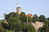 Sparrenburg
SparenburgNow usually spelt Sparrenburg
Castle in Bielefeld.
At Hünenburg we are dealing with a camp that is unanimously considered prehistoric;
at Sparenburg there was no reason until now to assume any high antiquity.
But since the mountain ridge on which Hünenburg lies allowed its builders a choice of site
and a view back along the orientation line, whilst the cone-shaped hill practically forced the site of Sparenburg,
the orientation of Hünenburg must have been directed towards Sparenburg, and thus the prehistoric use of the
Sparenberg would have to be judged the older.
The mutual dependence of the sites of these two castles is,
because of the exactness of their orientation on the east line,
exceedingly striking.
One must choose any one of the corners of the present Sparenburg building,
if one wants to have any noticeable deviation from the astronomical line.
The distance apart is short – only 4 km across a valley and a ridge –
and in judging it one is not misled by rival points of any kind.
I count it (as far as Brake) among those which one should first come to terms with,
if one wishes to form an opinion on the subject.
For the same purpose I also recommend Examples
4,
5,
11,
29,
41,
42,
47.
Sparrenburg
SparenburgNow usually spelt Sparrenburg
Castle in Bielefeld.
At Hünenburg we are dealing with a camp that is unanimously considered prehistoric;
at Sparenburg there was no reason until now to assume any high antiquity.
But since the mountain ridge on which Hünenburg lies allowed its builders a choice of site
and a view back along the orientation line, whilst the cone-shaped hill practically forced the site of Sparenburg,
the orientation of Hünenburg must have been directed towards Sparenburg, and thus the prehistoric use of the
Sparenberg would have to be judged the older.
The mutual dependence of the sites of these two castles is,
because of the exactness of their orientation on the east line,
exceedingly striking.
One must choose any one of the corners of the present Sparenburg building,
if one wants to have any noticeable deviation from the astronomical line.
The distance apart is short – only 4 km across a valley and a ridge –
and in judging it one is not misled by rival points of any kind.
I count it (as far as Brake) among those which one should first come to terms with,
if one wishes to form an opinion on the subject.
For the same purpose I also recommend Examples
4,
5,
11,
29,
41,
42,
47.