{193}
Read 3rd May 1923.
The occurrence of orientation in prehistoric structures has long been noticed. It has not, however, received from investigators much more than a passing comment, such as ‘the barrow is directed to the eastward’, or ‘the entrance to the chamber faces the north-west’. If a definite bearing is given, it is rarely stated whether it is ‘Magnetic’ (such as is obtained from a prismatic compass), or a True Bearing, i.e. an azimuth.
The vagueness, and the variability in direction thus indicated, have brought about indifference to the subject of orientation, doubt, or even complete disbelief in its occurrence in any megalithic structures.
Discredit and even derision have, moreover, been brought on the whole subject through the visionary ideas of some enthusiasts, who have tried to import into the subject far more than the cold facts of science can sustain; so that, with them, we become confronted by numbers of (neolithic) ‘astronomer-priests’, sacrificing to the Sun, singing psalms to the Moon, and saluting the Stars. Even the numbers of stones composing a Circle, and the ‘cubits’ that are comprised in its dimensions, have been called upon to provide mystical figures and proportions—an entire prehistoric arithmetic and astrology. It is no wonder, then, that the unmathematical, but otherwise scientific, archaeologist has repelled any suggestion of orientation in these ancient structures.
The truth of its existence has, however, to be faced. Whenever, as in the examples to be presented in this paper, exact methods of land-survey and of practical astronomy are brought to bear on the problem, all vagueness of direction is found to disappear, and the very remarkable fact emerges of definite and exact orientation in these monuments to certain points of the horizon, limited in number, at which sunrise or sunset takes place on days of the year still remembered and acknowledged in our calendars, and (to some degree) in our daily life, as dates of religious or other significance.
Before proceeding further, some explanation is needed, so that the reader may clearly understand in what ‘orientation’ consists, as applied to the monuments to be described later in this paper.
{194} There are two kinds of orientation, namely, terrestrial and celestial orientation. With the first of these two we are not here concerned. It is that orientation, or ‘lay-out’, of a structure which is made with reference to some local object; so that the outlook shall be, perhaps, towards some special mountain, or river, or scene of natural beauty; or, perhaps, for convenience, in order that a building may take up the line of a road or a street. To these should be added orientation towards some holy place or city, such as towards Mecca, as practised by Mahommedans.
Celestial orientation, on the other hand, is the lay-out of a structure with reference to the point of the horizon at which the Sun, the Moon, or some Star may be seen rising or setting, on some particular day of the year. It refers also to a lay-out towards the North point or the South point of the horizon, or of the heavens—the indication, namely, of the Meridian.
Celestial orientation may be conveyed by three different methods, as follows:
First, through being introduced into the lay-out of the actual megalithic structure. It becomes apparent to the eye chiefly when the ground-plan of a monument has been plotted, and the angle that its axial line makes with the True Meridian of the position is correctly laid down. This form of orientation should always be present, but can be supplemented by either or both of the two other following methods.
Secondly, by means of sight-lines taken from some point within the monument to an artificial object, such as a pillar stone, cairn, or boulder placed at some distance outside it, on the required azimuth, either on the sky-line or elsewhere.
Thirdly, by means of sight-lines to some conspicuous natural object, such as a sharp hill-top, a ‘tor’, or sometimes a marked dip in the hill-horizon seen against the sky.
The chief difference between the second and third forms lies in the fact that in the third the monument itself has to be built in such a position that the natural object shall be on the proper azimuth from it; while in the second the geographical position is of no particular concern; for the cairn or standing stone, etc., can be placed by the builder in any desired position as regards the monument, on the sky-line or otherwise. Though this last form is, naturally, the most certain and satisfactory to the investigator, the other must by no means be discarded.
As regards celestial orientation generally, the instances of its occurrence which form the subject of this paper are those which refer to Sun orientation only.
In the opinion of the writer, it will be possible eventually to establish the {195} existence of Star orientation, and perhaps also of Moon orientation. It seems but logical that both should occur, if orientation can be accepted as regards the Sun. There is, however, as yet not enough definite scientific evidence available to prove either that of the Stars or of the Moon. In the remarks that follow a passing reference will, however, be made to Star orientation.
Nor will the question be entered into of dating the construction of any monument through the change in obliquity of the Ecliptic (and consequent change in azimuth of sunrise, etc.), which has taken place since its erection, though this is one of the important sequels to the proof of the existence of orientation in megalithic structures. It is a whole large subject of its own, and one of which the physics and mathematics on which it is based are more suitably discussed elsewhere; though it embraces several archaeological considerations also. It may be said, however, that the dating of monuments in this manner is possible only in the case of Star orientation.
With Sun orientation the change in azimuth of the point of sunrise at the two solstices (which are the only points of the Sun’s annual movement concerned) is very small; and, at the latitude of London, has amounted to less than 1° of bearing in the past four thousand years. An error in the estimated azimuth of the axial line of a megalithic structure of only 1 1/3 minutes of bearing (1′ 20″) would suffice to throw the resulting date out by a hundred years. No one who has made an accurate ground-plan of these ancient ruins, and who has thus been able to realize the irregularity of their lay-out, would allow that so close an accuracy was possible. The probability of error is certainly ±20′ of bearing, if not more. Besides this, there are other important objections, into which we need not enter here.
In the case of the Stars, however, the change in azimuth of any star-rise is very much greater; so that, as regards dating, an error of determination of the axial line of a monument becomes less important. The group known as the Pleiades, for example, during the period 2000 to 1000 b.c., changed the azimuth of its rising point by 9° 2′, or at the rate of 54′ 10″ of bearing per hundred years. An error, consequently, in the bearing of an axial line of ±20′ would not, in this case, greatly affect the resultant date.
Following this general statement on orientation in its various forms, it is now necessary to give further particulars respecting Solar orientation, with which this paper is specially concerned.
It must be realized, first of all, that there are practically no traditions or written statements extant referring to the orientation of megalithic structures. We are almost wholly in the dark: nothing adheres to the memory of these monuments of antiquity in the countryside in which they are found, beyond, {196} occasionally, some strange or fanciful name; some ancient custom; some connexion of the stones with ‘the Druids’, with magic, or with fairies.
In any attempt to recover their history and meaning we are thrown, therefore—
(1) on the results of scientific observation, above ground;
(2) on whatever relics, such as grave-furniture, may be found on each site, at measured distances below the present land-surface; and
(3) on any analogies which may be made with similar structures in other lands.
With regard to orientation, which comes under the first and last of these categories, the lines of direction, or azimuths thus disclosed, and now to be described, are found to be those of certain specific sunrises or sunsets. It is necessary to say here that these azimuths were not, as it were, ‘forced’ on the subject by any preconception of the surveyors as to what ought to be found in it. The contrary is the case. It was the monuments themselves that, first of all, instructed us in the special azimuths on which they were laid out. Orientation was not suspected by the earliest investigators; and the idea has gradually evolved from being first a mere suspicion, next into a possibility, expressed in wide terms of bearing, and now into some approach to certainty, as surveys of existing monuments have become more accurate and their azimuths more correctly calculated. When the plans of various megalithic structures thus surveyed are brought together for comparison, with their azimuthal lines accurately laid down, it is seen at once that there are certain identities of bearing between them. The fruit of these comparisons (so far as orientation is concerned), namely, the actual sunrise and sunset bearings that have been discovered, are those shown in the following diagram (fig. 1), the actual bearings there shown being those observable at a position, chosen for convenience, in latitude 51° 30′ N.
The plans of a few of the actual monuments in which these azimuths are found (a representative selection from surveys made by . the writer) will be given further on, with short descriptions in each case.
At any fixed position on the Earth, during the course of a year, the point of sunrise moves northward from a point on the south-eastern horizon of an observer, reached on (about) 22nd December, and named the Winter Solstice, to another extreme point on the north-eastern horizon, reached on (about) 21st June, and named the Summer Solstice. The Sun then moves back again southward to the extreme point reached in December, and so on.
The azimuth of these two extremes of the Sun’s path—the points of Solstitial sunrise—are frequently found in megalithic structures. We may conjecture that these were probably the first two facts of solar astronomy to be noticed; and, as the observation of these events denotes residence at a single spot for at least a whole year, we may infer that the race of mankind who first acquired {197} this knowledge had reached a fairly settled stage of civilization, and that they probably practised agriculture.
From a calendar point of view these two sunrise events divide time into equal portions, as reckoned by days, into what we should term half-years. We find from the monuments that a further subdivision of time became necessary, either from agricultural motives, from religious motives, or from motives connecting the gift of food with prayers for that gift, required to be made at auspicious moments to the Giver.
{Fig. 1}
Accordingly, the position of sunrise on the middle day between the two Solstice extremes was noted; producing the dates known to us as the Equinoxes, namely 21st March and 21st September of our calendars.
The period between one Winter Solstice and the next—one year—was thus divided into four equal portions of days.
The conjecture may here be hazarded that these divisions would probably suffice, from an agricultural point of view, for peoples inhabiting tropical or semi-tropical countries; but in temperate regions a different arrangement of, times for sowing, reaping, etc., would become necessary, while not abandoning the original dividing points of time.
However this may be elsewhere, in Scotland and in Ireland azimuths are {198} found to the sunrises of the days that halve the periods between the Solstices and the Equinox, thus dividing the year into eight equal parts. In our present calendar these dates are 4th February, 6th May, 8th August, and 8th November.1
1The actual dates of the present calendar on which the Solstices, Equinoxes, and ‘Half Quarter-Days’ fall are liable to alteration, owing to the operation of the Gregorian Calendar, through the fact that the Tropical year is not an integral number of days. The Summer Solstice, for example, may fall on 20th, 21st, or 22nd June. For an explanation, the reader is referred to the notes on the ‘Longest Day’, given, under the astronomical events for June, in Whitaker’s Almanack.
Some recollection of these ancient divisions of time remain to-day. In England, for example, payment of rent is made on ‘quarter-days’—namely, at the Solstices and Equinoxes. In Scotland rents are paid on the ‘half-quarterdays’—which now, through changes in the calendar, presumably, are reckoned each of them three days later than those given above in February, May, etc. A lingering taste of Pagan days may also be discerned in the recognition of ‘May Day’ and of ‘All Hallows’, with their fairies, witches, and divinations for ‘luck’. These are common to all the British Isles, though the dates have now become transferred to 1st May and and November respectively.
In the prehistoric monuments both of Scotland and Ireland orientations to the sunrises of the (astronomical) half-quarter-days are fairly common.
In the latter island, the tradition is that the May Day Festival, which is named ‘Bealltaine’ in Gaelic, was established by King Tuathal, the Acceptable, who reigned in the first century of the Christian era. If this is true, it would appear that the construction of Stone Circles, or of other megalithic remains containing this orientation, persisted to what may almost be called recent times.
There are thus five sunrise-points of the Eastern horizon, and five sunset-points of the Western, to which orientations have been found. Besides these, there is also found the line of the Meridian, true North and South. How these two points of the sky or of the horizon were decided on by the builders of megalithic monuments it is not yet possible to say; but their occurrence is undoubted.
It is necessary to state here that these twelve azimuths are the only ones ever found among solar orientations in these islands; and also that, so far as it is possible to recover them, they are exact for the dates whose sunrises and sunsets are indicated. There is sometimes an error up to 3° or 4° in the Meridian line, which is perhaps intelligible, since it could not have been indicated by sunrise or sunset; but usually this orientation, too, is exact.
The angular space given on the diagram (fig. 1) at each sunrise-point now needs explanation. In these latitudes the Sun, at no time of the year, either rises or sets perpendicularly; but always at an angle with the horizon. That is {199} to say, as it rises or sets, it is also constantly changing its azimuth (or ‘bearing’). If, for example, from some inland position, the first appearance of the Sun were over a mountain crest, elevated 5° 00′ above the level of the observer’s eye, its azimuth would be considerably different from that seen from the same position, if the mountains were removed, and the sunrise took place above the level horizon—elevated 0° 00′, as it would be described mathematically.
In these investigations for orientation we have to put ourselves in the position of the original builders of the monuments, and see sunrise or sunset as they saw it. Then, by mathematical methods, to deduce from the azimuth and altitude at which they saw it, the date of the particular sunrise or sunset in question. The radial lines, accordingly, shown in the diagram, indicate the difference in azimuth on each particular orientation between a sunrise or sunset seen on an horizon elevated 0°, and one elevated 5°, all at the latitude 51° 30′ N.
The azimuths given include the necessary corrections for atmospheric refraction, and horizontal parallax of the Sun. In the absence of knowledge as to whether the point of first emergence of the Sun above the horizon was that looked for by the builders of these monuments, or whether the moment of complete emergence was taken, when the whole disc of the Sun was seen standing on the horizon, the azimuths given are calculated for the mean point—the Sun’s centre.
This may seem to be an unnecessary refinement; but in southern England, for example, the Sun changes its bearing while rising from about 20′ to 40′, according to time of year, between the moment of first emergence and of that of the complete disc being visible. In northern Scotland the change is considerably greater.
Some definite point within the sun’s perimeter must therefore be chosen, if only for the purposes of mathematical calculation; and the central one is obviously the best.
We may now proceed to demonstration of actual examples of the various kinds of orientation shown in fig. 1, as discovered in several different types of megalithic structures.
It is not possible to identify any particular orientation with any single class of monument: indeed, in many cases, two or more different orientations are discoverable in the same monument; but the demonstration will be made as widespread as possible, in order to show that orientation exists in all of them, of whatever description.
{200}
It will, perhaps, be best to begin with that type of monument which is probably the most ancient, is certainly the simplest, and seems to have no other signification than to indicate a line of direction—an ‘orientation’. The reference is to Stone alignments of two or more megaliths.
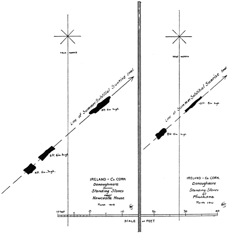
Groups of two, three, five, or more Standing Stones placed in a single alignment are fairly common in the south of Ireland; and, on first seeing them in the field as they stand, we might, at a cursory glance, consider them as almost {Fig. 2} devoid of interest. When, however, a survey is made showing the plan of the stones at the point of emergence above the (present) land-surface, and when they are plotted, as above, with the respective Meridian lines properly laid down, with the north end upwards in each case (as in every modern geographical map), a considerable point of interest arises; for then the orientations become at once apparent. In the instances shown, it happens that both groups are directed to Midsummer (Solstitial) sunrise; but this is not invariable with this type of monument, though it is frequent.
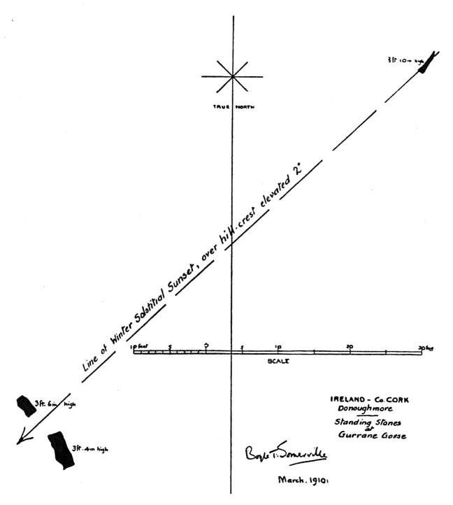
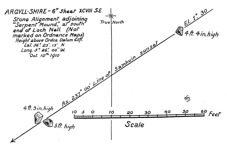
Another form of alignment, perhaps a later development, is that shown in fig. 3. Two examples are given: one in county Cork, and the other in Argyllshire, near Oban, at the southern end of Loch Nell.
{201} {Fig. 3}
{202} The desired orientation is obtained by an alignment taken from a single Standing Stone, through the gap or notch formed by two others standing close together. In the Irish example the stones are untrimmed slabs of moderate height, and the alignment indicates the Winter Solstitial sunset.
In the Scottish group, three large rough pyramids of stone have been chosen and placed in the required position to produce one of the ‘half-quarter-day’ orientations, namely that of 8th November. This date (or rather that of 2nd November, to which, as explained above, it has been transferred) is specially named ‘Samhuin’ (pronounced almost as ‘Sow-wen’) in Gaelic, both in Ireland and in Scotland.
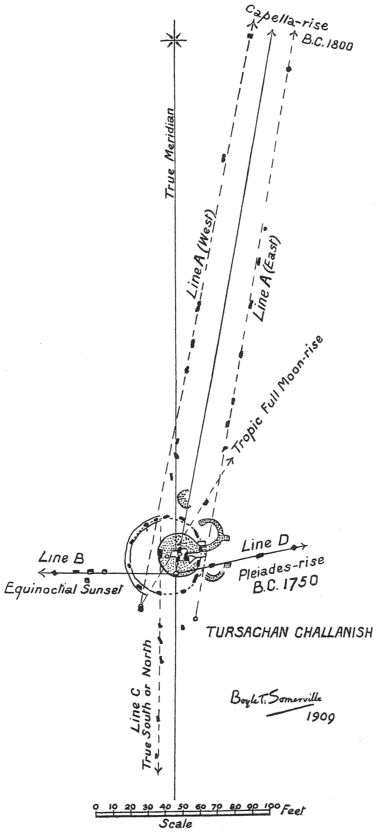
A very conspicuous instance of alignments is exhibited in the plan (fig. 4) of the great monument of Tursachan Challanish, standing on a bleak moorland peninsula on the west coast of Lewis, in the Hebrides, fourteen miles across the island from Stornoway. The positions of all the stones standing in 1909 is shown, and their relation to the True Meridian.
The main scheme of the monument consists of four alignments of Standing Stones, of differing lengths, all radiating from a common centre: the whole structure being roughly cruciform. There is one alignment running. due South (true); a second, shorter one, directed West (true) to the point of sunset at the Equinoxes.
These are both of them (probably) Sun orientations. A third alignment, a short one, like the western arm, is directed a little to the northward of true East; and a fourth alignment, by far the longest of them all, and presumably the most important since it is doubled so as to form an ‘avenue’, is directed a little to the eastward of North (true). As the builders (if so they may be termed) of this monument had evidently no difficulty in laying out with exactitude either the line of the Meridian—or South (true)—or of the Equinoctial sunset—West—we must suppose that the deflexions of the two other alignments from true East and true North respectively were made with fixed purpose.
As the azimuths on which they are laid out do not refer to the Sun on any of the usual days of orientation—and that to the northward not to the Sun on any day whatever—we are probably justified in considering these lines of stones as having been directed to certain star-risings.
The subjects of Star orientation, and of the dating of monuments through orientation, have been purposely excluded from this paper; but it may at least be remarked that along either line of stones forming the long northward avenue the star Capella (α Aurigae) was seen rising above the hill-horizon in that direction just before sunrise on the day of the Winter Solstice in 1800 b.c.; and that along the Eastern line the conspicuous star-cluster known as the Pleiades was seen rising, also just before sunrise, on the day of the Spring Equinox {203} {Fig. 4} {204} (21st March) in 1750 b.c. Both stars thus rose ‘heliacally’, as it is termed, and each of them warned, by its rising in the dawn, one of the regular sunrises of {Fig. 5} solar orientations. The closeness of the two dates thus arrived at, and the connexion of the star-risings with the solar events above noticed, is at least interesting; for it is of just such ‘warnings’ by certain stars (amongst which {205} are named Capella and the Pleiades) that mention is made by Virgil, when singing of the affairs of agriculture.
With the remaining structures at Challanish, shown on the plan, namely the so-called ‘Circle’ (which is an oval), the great Standing Stone, and the small cist-burial, lying within its perimeter, we are not here concerned. A full {Fig. 6} description will be found in a paper by the present writer which appeared in the Journal of the Royal Anthropological Institute in 1912, vol. xlii, p. 23 et seq.
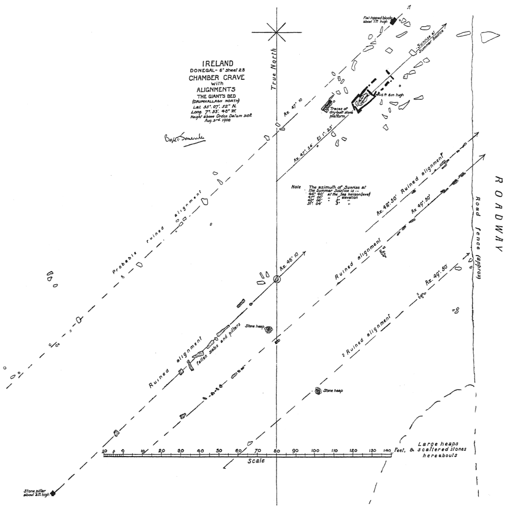
The association of stone alignments with other monuments is occasionally found among the megalithic remains of these islands; and the Chambered Grave shown above, in fig. 5 with its accompanying alignments, may serve as a notable instance. Though both grave and alignments are grievously ruined, the orientation is quite undoubted, and is to the Summer Solstitial sunrise.
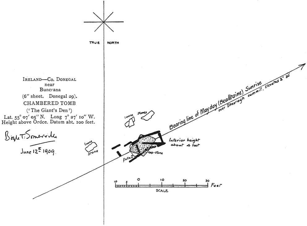
{206} Fig. 6 shows the ground-plan of a less-ruined Chambered Grave; in this example, without associated alignments. One of the great capstones, though {Fig. 7} not quite in its original position, still remains on its supporting slabs. The orientation, it will be noticed, is to a different point of the horizon from that shown in fig. 5, namely, to the sunrise of Bealltaine (6th May), one of the ‘half-quarter-days’ to which reference has already been made.
{207}
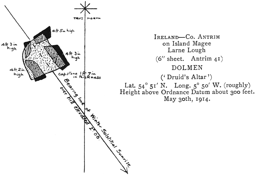
The structure illustrated in fig. 7 shows a transitional form between a true Dolmen and a Chamber Grave. Whether these two forms of monument were contemporaneous, or which preceded the other, need not now be discussed. The Chamber type, such as is here shown, was probably covered over, in all {Fig. 8} cases, by a tumulus; while the true Dolmen (at least in some cases) was not so concealed. There is, however, no vestige remaining of the tumulus in the present instance.
The monument is in a good state of preservation as regards its four massive supporting slabs, and even more massive capstone; but the closing ‘door’ (if {208} there ever were one, as we must suppose) and the contained burial have disappeared.
There is no uncertainty as to the orientation, which is to Winter Solstitial sunrise.
The accompanying view shows the appearance and present surroundings of this Chamber-dolmen. Civilization of the modern kind has overwhelmed it; and the monument, no doubt, of a hero, has become an ornamental rockery, facing the approach to a stucco-faced villa of the baser sort.
Another object of the same description as that in fig. 7 is shown in fig. 8. It is situated near Oban, at the south end of Loch Nell; and is named (probably for the sake of tourists) ‘Cuchullain’s Grave’. Traces of the original tumulus which covered it may be seen in the slightly elevated bank of earth which surrounds the Chamber-dolmen and an associated cist-burial distant from it a few feet. The orientations of these two burial-places are both definite and interesting, since two different sunrises are involved.
‘Cuchullain’s Grave’ is directed to the sunrise of Bealltaine (6th May); and the small cist-grave to that of the Winter Solstice.
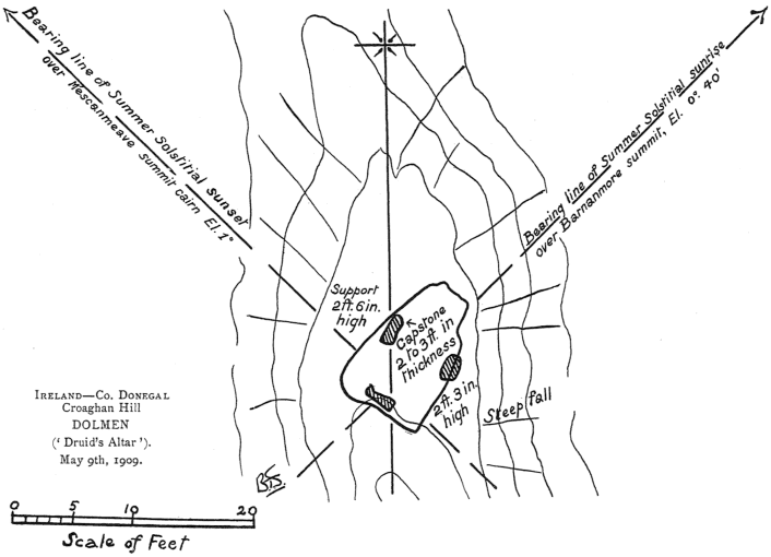
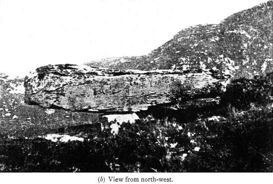
The object shown in fig. 9, plan and view, is of a true Dolmen; that is, it consists of a great single stone resting on supports, but not enclosing a Chamber. In this case the supporting stones are three in number, and are of no great height. Though possibly (and even probably) this monument was in the first place intended to be a place of burial, there is only just room beneath the capstone for a body to have been laid out flat on the rock floor on which the Dolmen stands. There is no grave-cavity or depression to be seen. The monument is placed in the midst of wild mountain scenery on the crest of a narrow rocky spur of Croaghan, county Donegal, at a point about 450 ft. above sea-level. It can never have been covered by a tumulus, for which there is neither ground space on the ridge crest nor material at hand, either of earth or stones, with which to make it.
We can only wonder by what means the great slab, which must weigh about four tons, was transported to this spot; or, if it was found near by in a natural condition, how it was lifted, even so little as 30 in., on to its three supports. There is no space for the necessary leverage—if levers were used—nor for men to manipulate them, for the ground falls away steeply on both sides We must also wonder how, besides being lifted, the great stone was directed, as is the case, towards the Summer Solstitial sunrise.
There is another orientation comprised, which, though not included in the actual structure, seems clearly to be intentional. This is an alignment towards Summer Solstitial sunset over the summit of a hill about two miles distant, named Mescan Meave. The meaning of this name is ‘Meave’s dish’— {209} {Fig. 9} {210} Meave (spelt Medb in Gaelic) was a certain renowned Irish queen of antiquity: the name is connected also with the ‘Queen Mab’ of fairy literature. The hill-summit bearing her name is crowned with a large circular group of stones, undoubtedly ‘prehistoric’ in character, possibly suggesting the idea of a ‘dish’. The fact that the bearing of this (marked) hill-summit lies upon an exact Sun orientation from the Dolmen seems to prove the connexion of the two objects.
We may now pass to the consideration of another type of monument, namely, that striking form of megalithic structures known as Stone Circles.
In this case orientation lines are usually indicated by specially prominent stones of the Circle, one at each end of the particular diameter which forms the desired alignment. The alignment is often, but not always, extended by means of a Standing Stone placed at some distance outside the Circle, and by this method the eye is directed either to an unmarked but prominent hill-summit, to a pronounced dip in the horizon, or (more satisfactorily) to some megalithic structure such as a Standing Stone, or cairn, or boulder.
Examples of some of these will now be given.
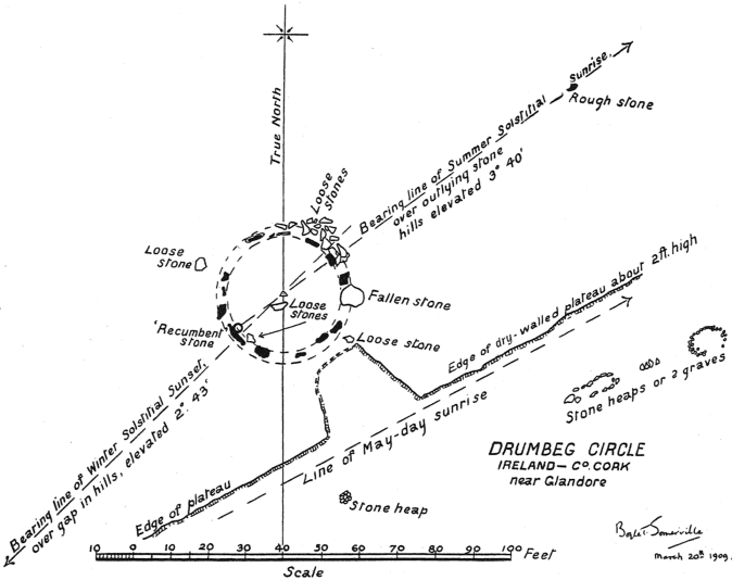
The Stone Circle of which fig. 10, a, shows the plan is situated in an open grass field, amidst very picturesque surroundings in the south-west part of county Cork. The sea is in sight from it, to the southward, distant a couple of miles.
This Circle has a peculiar interest, for it is, so far as the writer is aware, the only instance that has hitherto been recorded outside the Aberdeenshire area, of a Stone Circle which contains a ‘recumbent stone’ (so called) in its western segment. This fact is all the more remarkable when it is remembered that the south-west of Ireland is about as remote from the north-east of Scotland as any two parts of these islands well can be.
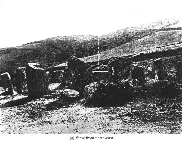
Connected with the recumbent stone there are two different lines of orientation. One, taken from the stone itself to the north-eastward, over the highest pillar stone of the Circle to an outlying rough block of stone (probably the foundation support of a pillar stone now disappeared), to a hill-crest beyond; indicating Summer Solstitial sunrise. The other, found in the opposite direction across the diameter of the Circle, looking southward over the recumbent stone to a remarkable gap in the hills, which is the line of Winter Solstitial sunset. The photograph (fig. 10, b) shows this line of orientation; but does not give the true effect on the eye of the gap in the hills. This is much more remarkable and abrupt than it appears here. A telephoto lens would be required to give the correct effect.
The land surrounding the Circle slopes to the southward; and there is {211} {Fig. 10} {212} well-marked evidence of a plateau having been constructed on which to build the Circle. The edge of this plateau is defined along its southern side by dry-walling about 2 ft. in height, in which there is a sort of ‘cove’ directed towards the Circle. It is probably intentional that this plateau-edge is directed towards sunrise of Bealltaine (6th May). The remains of what may possibly be cairn-burials, laid out in the same direction, are to be found in the near vicinity.
Another leading instance of orientation in a Stone Circle is shown in fig. 11. This is the plan of the great Circle crowning Beltany Hill, 1½ miles due south from the small but ancient town of Raphoe, county Donegal, in Ireland.
The somewhat rounded summit of the hill is made up (artificially) into a flat circular space, 145 ft. in diameter. The platform thus constructed is edged and defined by a circle of megaliths, of which sixty-four remain out of, possibly, an original number of eighty. The greater number are about 4 ft. high, as measured down their outer sides to the natural ground-level; while on the inner side, the tops of the stones are about level with the platform surface in the south-western part of the Circle, but stand up 1 ft. or 2 ft. clear of the platform elsewhere. There are, however, at certain points of the Circle, marked exceptions to this general height of the stones. The most noticeable of these is to the WSW., where there is a great slab, 2 ft. to 3 ft. in thickness, standing 9 ft. high, and about 8 ft. in width, in conjunction with a second considerable megalith, 6 ft. high.
Standing with one’s back to the greater of these two (which is by far the greatest stone in the Circle), and looking across the diameter on which it stands, to the ENE., one sees a large and prominent stone of the Circle, triangular in shape, with its sharp apex 4 ft. 6 in. above the Circle platform. Besides its conspicuous shape, this stone is individualized by having its whole inner surface (that facing the observer) covered with cup-markings. Continuing the line of the diameter on which it stands, there is seen beyond it against the sky, at a distance of about four hundred yards, a small but conspicuous hill-summit. This is now the site of an old windmill tower; but probably had in ancient times some sufficient indication of its purpose as a point of sight—a cairn, perhaps, or a pillar stone. The azimuth of this line, in any case, is precisely that of sunrise on Bealltaine (6th May); and it is important to note that the present name, ‘Beltany Hill’, gives the almost exact pronunciation of the Gaelic name of this ‘May Day’ celebration. This seems a very convincing proof of the connexion of the Circle with the date found by orientation.
Another orientation discoverable in this Circle is as follows. In the northwestern part of its perimeter there is another stone conspicuously greater and higher than its neighbours, though not so great as the Bealltaine-observing stone just described. It is 5 ft. 10 in. high, and about 8 ft. in width. Looking across the diameter on which it stands, the eye passes over a stone at the other {213} {Fig. 11} end (close, to which there is growing an ancient thorn-tree) to an outlying slab, or pillar stone, 6 ft. 3 in. high, which is ‘planted’ in the ground with its longer {214} sides parallel to the line of sight, at a distance of 67 ft. outside the boundary of the Circle. Beyond this pillar-stone, on the same line, there is a hill-summit seen against the sky, at some little distance. The azimuth of this line is (exactly) that of sunrise on the day of the Winter Solstice.
There is also an orientation across the centre of Beltany Circle to a conspicuous hill-summit named Croaghan, 3½ miles distant, crowned with an ancient earthwork, clearly seen against the sky. This line is that of sunrise at Samhuin (’All Hallows’), marking the November ‘half-quarter-day’; at six months’ distance in time, therefore, from that of Bealltaine, in May. It is unfortunate that the stones at both ends of the diameter of the Circle on this line have disappeared. The orientation should not, however, for that reason be rejected. It is not only inherently probable, but is exact in azimuth.
Yet another orientation is found in this interesting, and no doubt important, Circle by looking across a diameter from the westward over a great slab 7 ft. 3 in. high, flanked on either side by tall pillars, each about 6 ft. high, standing on the eastern edge—the three stones standing out conspicuously among their lesser neighbours. This line directs to the sharp summit of Argery Hill, two miles distant, and marks sunrise on the day of the Equinoxes (21st March and 21st September).
We may now pass to another type of structure, namely, to Round Barrows. These may perhaps be considered as cognate with Circles, in that there is generally included with them a peristalith, circular in shape, composed of either small or large Standing Stones.
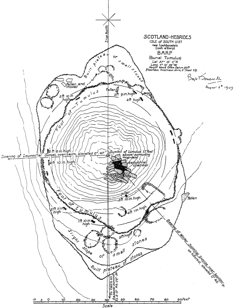
Near the village of Lochboisdale, on the eastern coast of the island of South Uist, in the Hebrides, there are three Round Barrows of similar construction and size, standing in different positions on the flat moorland, which extends widely to the westward of the main hill-system of the island. The local name for these objects is ‘Barp’, which, pronounced ‘Barr’p’, is, presumably, the word rendered in English as ‘Barrow’.
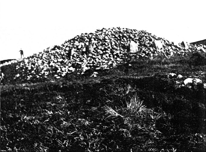
The three Barps are invisible from one another, and are separated by four or five miles in each case. Fig. 12 is a view of one of these barrows: the other two are almost precisely similar in appearance. They are each composed of small boulders or large stones, are from 75 ft. to 110 ft. in diameter, and stand up from 15 ft. to 20 ft. above the moor. Each is surrounded by a circular peristalith of smallish slabs, placed at intervals, of which a few remain, in each case, in situ. Each contains a Sepulchral Chamber megalithic in construction; but all of them are now ruined, and despoiled of their original contents. In view of the great similarity in construction of these barrows, it will suffice, in order to illustrate the remarks on orientation, to give the plan of only one of them.
{215} Fig. 13 is the plan of that one which is placed nearest to Lochboisdale village, near the head of a small arm of the harbour, named from the barrow ‘Loch a’ bharp’. There are traces of an original plateau, or foundation, on which the barrow itself was built. The plateau runs in a north and south direction, and probably was necessary on account of the marshy state of the soil at this place. The small circular and oval constructions of loose stones to be seen around the foot of the barrow are stated merely to be shelters for sheep, made by modern shepherds. The position of the Sepulchral Chamber is clearly indicated.
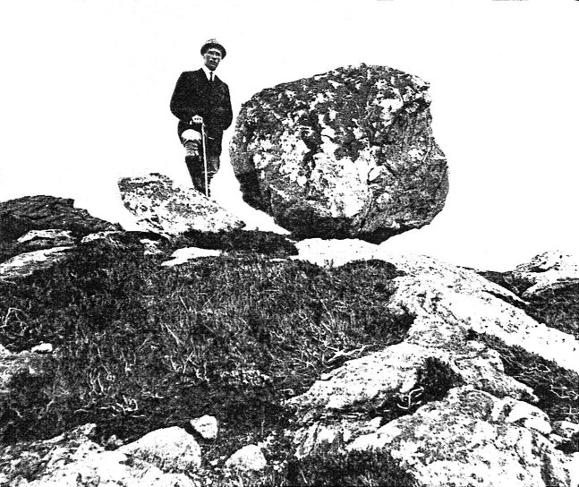
From the summit of the barrow there is a line of orientation to sunset on the day of Equinox over a small summit marked by a cairn, distant about half {Fig. 12} a mile. There are also probable orientations to the summit of Ben Shuravat, distant about 1½ miles, due North, and to Easaval, distant 3½ miles, nearly due South; but there is no cairn or other mark on these hills to render the orientations truly certain. There is, however, an interesting orientation to the sunrise of the day of Winter Solstice, about which there can be little doubt. This is provided by means of a large spherical boulder (fig. 14) which is seen from the Barp clearly against the sky, resting on the flat crest of a ridge of hills two miles distant—quite by itself, unmistakable, and on the exact azimuth.
It must be supposed either that the boulder was moved to this spot, or else that the barrow itself was constructed at such a point that this orientation might be fulfilled, as well as the others noticed above. This may account for the otherwise unsuitable, marshy spot at which it is erected.
{216} Barp Frobost (see view, fig. 12), which is distant five miles from that just described, lies on the exact Meridian line (North and South, true) which passes through the conspicuous (and cairned) summits of two hills, {Fig. 13} Reineval to the North, Askervein to the South, each distant from the Barp about a mile; while the sharp peak of Stulaval, 3½ miles away, lies precisely on the Equinoctial sunrise azimuth.
{217} The third barrow, North Frobost Barp, has Reineval bearing due South from its central point (the same summit, namely, that bears due North from Barp Frobost), and another orientation to the cairn on the summit of Arnaval, distant about 1½ miles, marking Equinoctial sunrise.
It is noticeable that all three of these barrows have orientations from them to the Equinoxes; and in two of them (possibly in all three) also to the Meridian line, North and South.
These instances of orientation may be concluded with those contained in the well-known ‘Clava Circles’.
{Fig. 14}
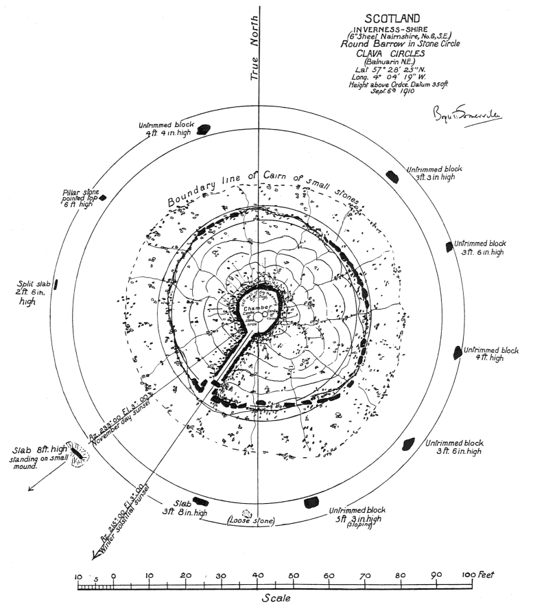
The small stream of the Clava runs in a valley immediately southward of Culloden Muir—the site of the famous battle of 1745—near Inverness. There is a strip of flat land along the southern bank of the stream, along which there is a series of prehistoric burial sites known as the ‘Clava Circles’. Relics of at least eight of them remain; and of these, the three best preserved are those in the vicinity of a farm-house named Balnuarin. It will thus be convenient to refer to them as ‘Balnuarin NE.’, ‘Middle’, and ‘SW.’ respectively. They do not lie on an exact line, and though separated from each other by only a few hundred yards, are not intervisible, owing to a shrubby growth of trees. They are close to the road, which indeed passes through the SE. part of the Circle pertaining to the southernmost of these three monuments.
{218} Their construction is somewhat unusual. It consists in each case of a Circle of megaliths, eleven or twelve in number, having a diameter of about 110 ft. Surrounding the centre of each Circle there is a tumulus, 55 ft. in diameter (namely, half that of the Circle), composed of smallish, rough stones. The tumulus, which is concentric with the Circle, is definitely outlined by a circular edging of (perhaps) trimmed stones, not very large, and mostly oblong in shape. A space of about 27 ft. in width thus exists all round between the foot of the tumulus and the surrounding megalithic Circle.
In the centre of each tumulus there is a Chamber, roughly circular in plan, shaped somewhat like a well, and 5 ft. or 6 ft. deep—a measurement which marks the present height of the best-preserved tumulus. No doubt there was originally a covering capstone to the ‘well’, with the stones of the tumulus heaped high over it; but this has, in each case, disappeared. The Chambers are faced internally with ‘dry-walling’, and each has an alley leading into it, through the thickness of the tumulus, from the south-westward. The Ordnance map of the locality has a reference that ‘Urns and burnt bones’ were found, but without giving a date, or more precise evidence as to any particular site.
Fig. 15 is a plan of the NE. Circle. It is in most respects the best preserved, and may serve as representative of all three. In the case of the Middle Circle, the tumulus is much ruined, and the central Chamber with its alley has disappeared; but no doubt they were of the same character as those of the companion barrows.
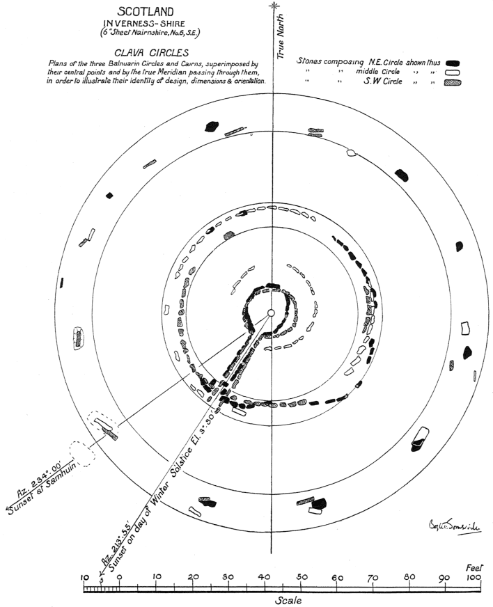
In order to exhibit more clearly the remarkable similarity of the character, of the dimensions, and particularly of the orientation of these three monuments, they are shown on fig. 16, all plotted together, overlying one another; the connexion between them being made by causing the three central points, and the True Meridian running through them, to coincide.
The stones composing each barrow are distinguished from those of the other barrows through those of the NE. being shown in solid black; those of the Middle, in outline only; and those of the SW. shaded with diagonal lines.
Examination of this ‘composite’ presentation of the three plans reveals that the only constructional differences to be noted lie (i) in the actual numbers of megaliths originally forming the Circles (but this must be to some extent conjectural, since some are missing), and (2) in the characters of the stones themselves.
With regard to the numbers of which each Circle was composed, if the distances between individual stones should be the same all round, then the NE. Circle and the SW. Circle probably contained twelve stones each (of which two stones and three stones respectively have disappeared), while the Middle had eleven stones (of which four are now missing). In spite of this disparity in numbers, it is observable that, in the southern segments, the positions of the {219} {Fig. 15} {220} stones of all three Circles have been made identical, or nearly so; the (inevitable) differences being confined to the northern segments.
With regard to the characters of the stones, the strange fact to be noted is that, in the NE. Circle, if a line N. 20° W. – S. 20° E. be drawn, the stones to the eastward of that line are all rough, more or less rounded, untrimmed lumps—possibly boulders from the river bed; while those to the westward are either well-trimmed, flat-sided slabs, or else are pillar-stones.
In the Middle Circle, one untrimmed lump remains at the NNE. point; and of those that remain, all are trimmed slabs.
In the SW. Circle, there are no untrimmed lumps; and the NNE. point is marked by two separate slabs, with a space between them of about 1 ft., the faces being parallel.
What these differences may signify—and certainly they seem intentional—it is not possible to say. Another point that requires noticing, as it has a decided bearing on orientation, is as follows. In each Circle there is one stone slab, larger and better trimmed than the remainder, which is given special importance over the remaining stones of the Circle. In each case it is placed in the SW. portion of the perimeter. In two cases (NE. and Middle Circles) the stone is rendered conspicuous through being surrounded by a small mound; and in the case of the NE. Circle, the slab is rendered, literally, hors concours, by being placed a little outside the Circle of the remaining stones. It is obvious that the stones in question are intended to mark some special point. The lines of azimuth passing through these stones from the centre of each Circle are absolutely identical; and on investigation it is seen that their direction is to sunset on Samhuin—‘All Hallows’—the ‘half-quarter-day’ of November.
In the case of the SW. Circle, a second stone, additional to that referred to above, is made prominent by being placed on a small mound. This stone lies on the azimuth (taken from the centre of the Circle) of sunset on the day of the Equinoxes.
The last point to notice is the exact identity of bearing of the alley leading from the central burial-chambers in the tumuli of the NE. and SW. Circles, and probably also from that of the ruinous Middle Circle, if we may judge from the one stone of it remaining in situ.
The azimuth on which these alleys lie is precisely that of sunset on the day of the Winter Solstice.
There could scarcely be a more convincing proof of the existence of orientation than is contained in these facts and coincidences. These Circles and tumuli were all probably constructed at about the same time—possibly they are the silent witnesses and monuments of prominent persons killed in the same battle, and contained their (cremated) remains.
This would account for the precise correspondence in design and in {221} {Fig. 16} {222} actual ground measurement found in these monuments. There is also precise correspondence in their orientation; and we can only infer that this, too, was intentional, and could not possibly be the result of mere chance. The fact that the azimuths involved direct to definite points of the horizon—to the lines of sunset at certain dates found in the orientation of many other prehistoric monuments—cannot be mere chance either. The real reason why these particular dates should have been chosen, however, eludes us. We do not yet know their purpose and origin, except by conjecture.
In the preceding paragraphs there have been brought before the reader five different types of megalithic monuments, and several examples of each type, in which there is undoubted evidence of exact orientation to certain definite points of the horizon (those, namely, set forth under fig. 1 at the beginning of this paper); such orientation being conveyed either in the ground-plan of each monument, in its geographical surroundings, whether artificially marked or not, or by both methods.
This is an initial contribution to the study of the subject, and contains merely leading and obvious examples from the collection of about ninety surveys of separate megalithic monuments made by the writer. The time has not yet arrived to state definitely that orientation of some kind, solar, stellar, or lunar, is to be found in all such structures; but in every instance in the above-mentioned small collection, where the ruined remains have been sufficiently extensive to justify a deduction of any sort, orientation of one kind or another has been found.
Only the fringe of the subject has as yet been touched, but the results seem sufficiently promising to continue the experiment, and to justify the plea that, when surveys of megalithic remains are made, they shall be scientifically exact in their ground-plan, and that this shall include the projection of the True Meridian on the plotted result.
A further plea is urgently advanced that in all published results of such surveys, the plans shall be presented under the same convention as that adopted by the whole modern world for maps and charts; that to which every one is accustomed from his youth up—namely, with the north end uppermost on the paper, and with the Meridian line parallel to the edge of the book, etc., in which it appears.
Only when the north and south line (true) lies in the same attitude on all plans is it possible to see at a glance the correspondence or otherwise of orientation between any two of them. What should we say if, in order to fit the coast-line neatly into the page of an atlas, and so save paper, the map of the British Isles were inserted either with Scotland thrust down into the lower left-hand corner of the sheet; or with the south coast of England laid closely {223} parallel with the right-hand border of the paper—with a small and unobtrusive arrow inserted to indicate the actual direction of the North Pole, true or magnetic? Yet this is what we are accustomed to in most scientific journals, in the matter of structural plans, and have borne with it hitherto without complaint.
It is not contended that the discovery of orientation will unlock all the secrets of these ancient ruins, concerning whose origin we know so little at present, but it will at least be one more fact to add to our scanty stock of knowledge regarding them; and perhaps may prove to be a more potent factor towards their elucidation than appears at first sight.
Quite large questions lie behind what, seemingly, is a small matter. Where did this world-wide custom of orientation originate? What was its purpose? Who introduced it into these islands? How was it carried out in practice?
If by direct observation of the rising or setting of the heavenly bodies, as in view of the exactitude of the azimuths seems to be certain, how was this possible, unless the British climate of those times was greatly different from that of to-day?
This consideration brings us into the large question of glaciation, and of the weather conditions that must surround regions covered with an ice-cap. All of these questions, borne in the lap of archaeology, arise out of the closer study of orientation in prehistoric structures, and all require answers.
Mr. Reginald Smith favoured the theory that the orientation of megalithic monuments depended on Sun-worship, as the solar year was more important than the lunar month to those who had learnt agriculture from the people who introduced the dolmen idea into Europe. The orientation of the stone chamber of a long barrow, parallel to an adjoining avenue or group of standing stones, was less easily explained, as the chamber was at once covered by the mound, even if the largest capstone remained visible. The stock objection to Sir Norman Lockyer’s theories was that if the orientation had no relation to the solstitial or equinoctial positions of the sun on the horizon, some prominent star was called in to explain the direction of a monument, and the choice seemed somewhat arbitrary. It had been mentioned in the paper that one enormous slab on low supports had never been covered with earth; and it seemed likely that the stone was in situ, also that it had been hollowed out underneath for the supports, as the transport of such a weight up a mountain seemed unnecessarily laborious. Whatever the quality of the British climate in the late Neolithic period—and more than one of the classical historians gave it a bad character—it would only have been necessary to fix the critical solar positions on the horizon on one or two occasions, and those occasions could be waited for. Mention had been made of the late Mr. A. L. Lewis’s researches on the same lines, and his independent calculations led to the same conclusions as those reached by Admiral Somerville, who had evidently made good use of his shore-leave when stationed at Lough Swilly and Berehaven.
Mr. R. C. Fowler asked if the author had ever observed a good enough line for stellar orientation. The solstitial points could be easily determined, but how were the equinoctial points found by such primitive methods?
{224} Mr. Leland Duncan inquired whether the solstitial lines shown on the screen were valid at the present day, or only for the period in which the megalithic monuments were erected. He had no doubt that some of them were connected with fire or Sun-worship; and the practice of lighting a fire on St. John’s Eve and All Hallows Eve was still kept up in the west of Ireland. In Leitrim people used to light a small fire on the hill-top at Midsummer to assist the sun to continue on its path, instead of turning back from the solstitial point.
Rev. G. H. Engleheart said it was difficult, and sometimes invidious, to adopt a negative attitude when an elaborate paper had been read to the Society; but sincere criticism was one of the functions and privileges of the Fellows, and he thought it was allowing too much latitude to choose any one of five points of sunrise or sunset on either side of the monument to suit the lines still furnished by the standing stones. If stars or adjacent eminences were admitted as objectives, it would be easy to explain any line so given, but such a method did not carry conviction. It was a suspicious circumstance in Sir Norman Lockyer’s system that when the sun did not explain the orientation of a stone circle, one star or another was adopted in its place. The explanation he preferred was that offered by Sir Arthur Evans in his last presidential address (Proceedings, xxxi, 192). He himself saw in the three Clava monuments a connexion with the primitive chamber and the primitive house of the living. It was a habit ingrained in the northern nations to turn their houses towards the sun, and the Laplanders had a buried avenue leading into their dwelling-room. That to his mind was the origin of megalithic orientation. To explain the alignment by astronomy seemed to him imputing to primitive man a vast amount of scientific knowledge. He felt sure the British climate was then much worse, and pictured the builders waiting year after year for a clear observation of the horizon on the critical day.
Mr. Lyon Thomson was stationed at Lark Hill, two miles from Stonehenge, during the war, and noticed that one hut in a row was missing, though the foundations were laid. Inquiry showed that a hut had originally been built there for forty men, but had been demolished as it would have prevented the midsummer sunrise being seen from Stonehenge.
Admiral Somerville agreed in reply that Sir Norman Lockyer had made too free use of the stars to explain various orientations; and such use was only justified in the case of heliacal risings, that is when a star rose just before the sun on one of the critical days and gave warning to the observers: thus the Pleiades heralded sunrise on May morning. The stars or star-groups suited for that purpose could be reduced to three or four, and only those had been used in his own calculations. The burial of an orientated chamber in a long barrow was as logical as the east-and-west position of many Anglo-Saxon burials that had left no traces on the surface above them. The great slab on the mountain side of Croaghan, co. Donegal, might have been of local origin, but its transport to the spot was not out of the question. As to the early British climate, Mr. C. E. P. Brooks in his Evolution of Climate had contended that there was an optimum between 4000 and 3000 b.c., with a continuous decline since that date. He had found Mr. A. L. Lewis a rich source of information with regard to megalithic monuments, and considered him one of the pioneers in the subject. To find the solstitial points was an easy matter, and the equinoctials were probably fixed by counting the days between the solstices and dividing by two. The difference in sun-rise bearing at Stonehenge due to precession was negligible, as it only amounted to 13′ 49″ in a thousand years. He did not accept terrestrial bearings such as hill-tops in his own observations.