Journal of the Anthropological Institute of Great Britain and Ireland, 25 (1896), 2–16 + Plates I, II
The second part of this paper (West Cornwall) was not published until 10 years later.
{2}
Prehistoric Remains in Cornwall.
By A. L. Lewis, F.C.A.
[plates i, ii.]
Part I.—East Cornwall.
The prehistoric remains of Cornwall have been the theme of so many archæological books and papers that it might well be thought that nothing remained to be said about them, especially since the publication by the Society of Antiquaries of the elaborate plans prepared by the Rev. W. C. Lukis and Mr. W. C. Borlase; but even this work, exhaustive as it appears to be, omits all mention of two large and important circles, and of another large and almost unique monument which I shall describe in the course of the present paper. Warned by the shortcomings of my predecessors, I shall not venture to suppose that I have to-day said the last word upon this apparently inexhaustible subject, but I shall be quite prepared to hear at any time that some more fortunate person has discovered something that has escaped my own notice as well as that of the more celebrated antiquaries who have preceded me.
The first monuments I propose to draw your attention to are the three circles called the “Hurlers,” which are 4 or 5 miles north from Liskeard and half a mile south from the curious natural pile of granite called the “Cheesewring.” They were most accurately surveyed by Mr. C. W. Dymond in {3} 1877, and his description and plan are in the “Journal of the British Archæological Association” for 1879, and they were also measured in 1879 by Messrs. Lukis and Borlase, whose plans and description will be found in the work published by the Society of Antiquaries. These three circles are in a line extending over about 530 feet and averaging about 15 degrees east of north, but the direction of the line from the centre of the south circle to that of the middle circle is 12 degrees east of north, while the line from the centre of the middle circle to that of the north circle is 181/2 degrees east of north. The three circles at Stanton Drew, near Bristol, are arranged in a similar manner, though the bearings are not quite the same. Mr. Dymond gives the diameters as 114, 140, and 108 feet for the north, middle, and south circles respectively: Mr. Lukis states them at 110, 135, and 105 feet only, but this difference may be attributed to the condition of the circles, which is very ruinous, there being only eighteen stones standing and nineteen fallen out of a total of seventy-five in the three circles, as estimated by Mr. Dymond. Their destruction has continued to quite recent times, for I found a stone in the northern circle in 1869 which Mr. Dymond also found there in 1870, but did not find in 1877, when he completed his plan, but which he has inserted therein with a note reporting its disappearance. Messrs. Lukis and Borlase who followed him in 1879 of course did not find the stone, and it does not appear in their plan. Mr. Tregelles who visited these circles in 1894 reports the disappearance of one if not two stones which Mr. Dymond found in the southern circle. About 400 feet from the middle circle, in a direction 21 degrees south of west from its centre, but in a line with its southern edge, are two stones about 5 feet high. The stones composing these circles are from 3 to 6 feet high and 1 to 3 feet broad and thick. The most remarkable object seen from the circles is the “Cheesewring” hill, which is 4 degrees west from north, and stands up on the sky-line in a manner which occurs so frequently in connection with the Cornish circles and the most prominent hills around them, as to cause an impression that the position of the circles was selected with a view to the effect to be produced by the hills.
Between the Hurlers and Liskeard is the Trethevy Stone, a dolmen forming a complete chamber, but standing not in but on a mound, from 2 to 3 feet high, which makes it difficult to believe that the dolmen was ever either covered or intended to be covered. There are seven upright stones supporting a capstone, 15 feet by 10 feet, at a maximum height of 10 feet from the floor of the interior; the capstone has a small hole at the upper end, which was probably cut to receive a cross at a {4} period long after the erection of the dolmen. This monument was first described by Norden in or about 1584 a.d., and is figured by Mr. Dymond in the “Journal of the British Archæological Association” in 1879–80, and by Messrs. Lukis and Borlase in the work published by the Society of Antiquaries.
Dozmare Pool, round which large numbers of flint flakes have been dug up, is about 5 miles west from the “Hurlers.” The flint appears to have been brought from Devonshire and made into implements, etc., at this place. There are also some single stones and other remains about the district.
At Duloe, 4 miles south from Liskeard, there is a small circle, consisting of eight large stones, the largest of which has been thrown down and broken. They vary from 3 to 11 feet high, 21/2 to 61/2 feet broad, and from 11/2 to 4 feet thick. I have not seen this circle myself, but it has been described and planned by Mr. Dymond in the “Journal of the British Archæological Association” and by Messrs. Lukis and Borlase in the work published by the Society of Antiquaries. Mr. Dymond says the diameters are from 34 to 39 feet, Mr. Lukis says the diameter is 361/2 feet, so perhaps he took the average. A small urn and other appearances of interment, which, however, may very well have been post Roman, have been found in the circle, and Mr. Lukis accordingly thought the circle was “probably the enclosing ring of a cairn which has been entirely removed.” This is an ordinary formula, but why so many cairns should have been entirely carted out from their enclosing rings as some archæologists would have us believe is by no means clear. Mr. Dymond says “Mr. Borlase now (1882) thinks it improbable that there was a tumulus within or near to the Duloe circle.”
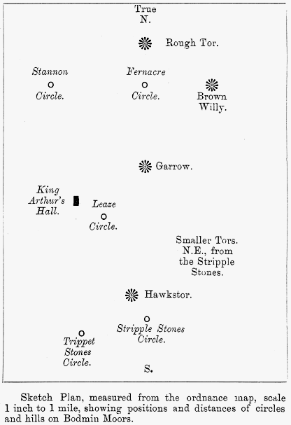
The most important and the least visited collection of monuments in Cornwall is situated on Bodmin Moors, clustering round Brown Willy, Rough Tor, Garrow, and Hawk’s Tor. The two former are the highest points in the county, and on their slopes are great numbers of ruined huts and enclosures constructed of unshaped blocks of stone without mortar, and also some small sepulchral circles, cists, etc. Amongst them is one perfect hut which was described by the Rev. S. Baring-Gould in the “Daily Graphic” of 4th September, 1891. Although there is no absolute proof that these huts and circular enclosures were the dwellings of the people who constructed the circles of separate upright stones which stand in their vicinity it seems most probable that they were, and that all belong to the same period, and, if we may judge of the Cornish huts from the results of the recent excavations in the huts at Grimspound and elsewhere on Dartmoor, that period must be a very early one. {5} No one who sees the hut circles and enclosures side by side with the open stone circles, as they are on these moors, can doubt for a moment which class any one of them belongs to, and it is important to note this at a time when attempts are being made to induce people to believe that Stonehenge has been roofed, and is only the skeleton of a dwelling of the Mediterranean type, and that the inner circles at Abury, though over 200 feet in diameter, were something of the same kind.
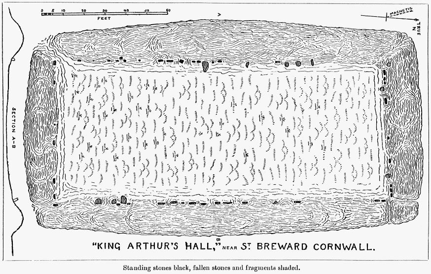
A very peculiar, I might say unique structure on Bodmin Moors is known as “King Arthur’s Hall.” It consists of a bank of earth, the present breadth of which varies from 12 to 20 feet at the base, its height varying from 5 to 7 feet; this bank encloses an oblong space, 159 feet long from north to south (within 5 degrees to west of north), 64 feet wide at the north, and 681/2 feet wide at the south. Twelve stones stand or lie in line inside the north end of the bank, eighteen inside the east side, six inside the south end, and nineteen inside the west side, They seem to have formed a kind of retaining wall to the inner side of the bank, but are mostly pressed inward by its weight, and some are nearly buried by its gradual wearing away. These facts, coupled with the probability that the lines, if not absolutely continuous, were originally much more complete than they are now, lead me to suppose that several stones may be quite covered, but this can only be ascertained by digging or boring. The largest stones remaining in position are about 5 feet high. The middle of the enclosure is a foot or two lower than the ground outside, and is full of water, which finds a vent at the south-west corner. All the corners of he embankment are more or less broken and rounded, and it is lower at the north and south ends than at the east and west sides, but there is no appearance of any special entrance, the angles of the lines of stones being well defined, except, perhaps, at the south-west corner. Rough Tor, Brown Willy, and Garrow, form a trinity of hills covering 30 degrees of horizon, 15 on each side of the north-east; Hawkstor is south-east. This extraordinary monument, the purpose of which it is difficult to imagine, is neither planned nor mentioned in the work on Cornish rude stone monuments by Messrs. Lukis and Borlase, published by the Society of Antiquaries; it has a slight resemblance to two enclosures in Brittany described by Admiral Tremlett in the “Journal of the Anthropological Institute” for November, 1885, the entrance to each of which was at a corner. These appeared to have been used as places for cremation, but we have no evidence as to the use of “King Arthur’s Hall.”
{6} There are upon these moors five circles, from each of which Rough Tor is seen as a most conspicuous object, and of the five circles two stand in a line with it, nearly due north and south, and two others in another line with it, 11 to 12 degrees east of north; two of the circles are also in line with Brown Willy nearly due east from them. The distances between the circles taken on the level on the 6-inch ordnance map show remarkable proportions to each other, and these peculiarities of positions and distances seem to make it probable that the circles, though far and mostly hidden from each other, were all erected as part of one great scheme, a subject which I will revert to after briefly describing the circles themselves.
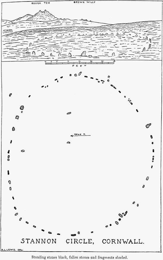
The Fernacre Circle, the most north-easterly of the group, was very probably the first to be erected. It stands on sloping ground, with Brown Willy nearly due east, Rough Tor due north (not west-north-west, as Mr. Lukis has said), and Garrow due south, all standing up boldly around it. As Mr. Lukis had published a fully detailed plan, and as the time at my disposal was short, I did not measure it. He said it consisted in 1879 of ten fallen and forty-five erect stones, some of which were very small, and some between 3 and 4 feet high, and he thought they had sunk or become overgrown. I doubt whether this be the case to any great extent, still Mr. G. F. Tregelles found forty-five stones standing and “nineteen almost disappearing in the peaty soil” in 1893, and the nine which he found and which Mr. Lukis did not find may have become visible by a shrinking of the turf. Mr. Lukis says the diameter of this circle is 140 feet, but his own plan shows it to be 146–7 feet, and, on checking his stated measurements to ascertain the exact diameter, I found that three of them were not correctly laid down on his plan, the effect of which is to misplace one of the stones by about 4 feet. There is a small outlying stone about 160 feet east from the circle, directly in line with the highest peak of Brown Willy, and this fact, together with the position of the circle relatively to the three hills and to the Stannon and Stripple Stones circles, leads me to suppose that, if the distances between the circles were really measured, this was the circle from which the measurements to the others were taken.
The Stannon Circle, the most north-westerly of the group, is the nearest to the Fernacre Circle, and is in a direct line with it and Brown Willy, and also with the small outlying stone to the east of the Fernacre Circle, and was therefore, perhaps, the second in order of construction. It consists of about seventy stones and fragments, of which thirty-three are upright, but none of them exceed 5 feet, and some are not more than 2 feet in height. The diameters of the ring are 138 feet from east to {7} west and 1251/2 feet from north to south, there being a peculiar flattening of the northern side, in which respect it resembles Long Meg Circle in Cumberland. Rough Tor, a little more than a mile distant, and ranging from 20 to 24 degrees north of east, is by far the most conspicuous object seen from it, and its granite carn, showing two peaks with a lower one between, would present a very remarkable appearance if the sun framed itself between there, as it probably does at some time in the year. Brown Willy is almost entirely hidden by a ridge of no great height, which also conceals Garrow and the Fernacre Circle entirely, but, looking due east, three of the peaks of Brown Willy may be seen peeping above the ridge and forming a triple summit, an appearance which I have noticed in connection with several other circles. The Stannon Circle is neither mentioned nor figured by Messrs. Lukis and Borlase in their work published by the Society of Antiquaries.
The Stripple Stones Circle is at the south-east angle of the space marked out, so to speak, by the position of the circles. It is on the south-eastern slope of Hawkstor, and looking due north from it the top of Rough Tor will be seen over Garrow, the Fernacre Circle being in the same line but out of sight in the hollow between them. This circle differs from all the rest in being surrounded by a ditch, 11 feet wide, with a low bank of about the same width outside it; there is but one entrance, which opens exactly in the direction of the Trippet Stones Circle, about 13 degrees south of west, but there are three semi-lunar projections in the vallum (W.N.W., N.N.E., and E.) Mr. Lukis stated the diameter of the circle to be 1481/2 feet, but it is doubtful from his own plans whether it is not 2 feet less, exactly the same as that of the Fernacre Circle. A stone, 12 feet high, stood in the centre, but is now fallen, as are twelve of those left of the circle, there being only four standing, which are from 4 to 6 feet high.1 One of the fallen stones was 12 feet long, but if now in its original position, must have stood outside the circle, but inside the ditch and vallum. The original number of stones composing the circle itself, was, in Mr. Lukis’s opinion, 37, but Mr. Tregelles thinks the number to have been more probably 28, which also seems to me more in accord with Mr. Lukis’s own measurements. At a short distance2 from the eastern side of the circle there is a small barrow with a central cist. Hawkstor is 60 degrees {8} north of west from this circle; Rough Tor and Garrow are in line due north, Brown Willy covers from 15 to 18 degrees east of north, and a trinity of lower hills extends from 35 to 65 degrees east of north.
1 There were five standing when Mr. Lukis made his plan in 1879, but Mr. Tregelles found only four standing in 1893.
2 Mr. Lukis says 232 feet, Mr. Tregelles says 110 feet. I did not measure the distance myself, in 1891, as there is no apparent connection between the barrow and the circle.
The Trippet Stones Circle is at the south-western angle of this group of four circles, and is the smallest of them, its diameter, according to Mr. Lukis, being 104 feet 7 inches. When I visited it in 1891 there were eight stones standing and four fallen, one of which had fallen since Mr. Lukis made his plan in 1879, and, as they were all surrounded by pools of water, the downfall of some of the others may be confidently expected. The height of these stones varied from 4 to 5 feet, an additional foot or so being sunk in the ground. The interval of about 121/2 feet from centre to centre, which seems very regular between the remaining stones, would indicate their original number to have been twenty-six or twenty-seven. There is a small stone inside the circle, but it is a modern boundary stone, and there is another a short distance due east. Two stones are in a north-westerly line from the (outer S.E.) edge of the circle to Carbilly Tor, a very inconsiderable eminence. Rough Tor and Brown Willy form with Hawkstor a trinity of hill-tops extending from 12 to 62 degrees east of north.
The Leaze Circle is situated nearly in the middle of the trapezium of which the other four circles form the corners, but is not visible from any of them, and does not appear to have any relation to any of them except that it is in the same line from Rough Tor as the Trippet Stones Circle. It consists at the present time of ten stones standing and one fallen; they are from 3 to 4 feet high and one to two and a half in width and thickness, there are also four or five fragments, three of which are buried in a fence which cuts the circle in halves. The diameter of the circle appears to have been 831/2 feet, but its south-eastern segment is wanting. Rough Tor is on the whole the most conspicuous hill, and covers the horizon from 10 to 20 degrees east of north; Garrow extends from 30 to 40 degrees east of north, and hides Brown Willy; Butter’s Tor makes a third eminence at about 30 degrees north of east; Catshole Tor is 24 degrees north of east, and Hawkstor 73 degrees south of east. There are some outlying stones about 10 degrees east of north which may however have formed part of a cist, and there are what appear to be the remains of another circle a short distance to the north-west, between the Leaze Circle and King Arthur’s Hall. None of these remains are mentioned or figured in the work by Messrs. Lukis and Borlase published by the Society of Antiquaries.
I have already mentioned that there is a remarkable propor-{9}tion between the distances of four of these circles from each other; the distances are, as nearly as can be ascertained from the 6-inch ordnance map:—
| Fernacre to Stannon | 6,275 | feet | = | 3,000 | cubits of 25·1 inches. |
| Stannon to Trippet Stones | 16,400 | „ | = | 7,840 | „ |
| (for 8,000 cubits.) | |||||
| Trippet Stones to Stripple Stones | 4,180 | „ | = | 1,9981/2 | cubits of 25·1 inches. |
| (practically 2,000.) | |||||
| Stripple Stones to Fernacre | 15,730 | „ | = | 7,520 | cubits of 25·1 inches. |
| (practically 7,500.) | |||||
| Fernacre to Trippet Stones | 16,880 | „ | = | 8,070 | cubits of 25·1 inches. |
| (for 8125.) | |||||
| Stannon to Stripple Stones | 16,850 | „ | = | 8,055 | cubits of 25·1 inches. |
| (for 8125). | |||||
The Leaze Circle may have been intended to be at the crossing of the diagonal lines from Fernacre to Trippet and from Stannon to Stripple, but is about 700 feet north of that point—perhaps the original intention was varied in order to get the Leaze Circle in a particular line with Rough Tor.
The diameters of the circles are:-
| Fernacre | 146–7 | feet | = | 70 | cubits of 25·1 inches. | |
| Stannon | { | 138 | „ | = | 66 | „ |
| 1251/2 | „ | = | 60 | „ | ||
| Trippet Stones | 104 ft. 7 ins. | = | 50 | „ | ||
| Stripple Stones | 146–7 | feet | = | 70 | „ | |
| Leaze | 831/2 | „ | = | 40 | „ | |
The cubit of 25·1 inches, which Professor Flinders Petrie calls an Egyptian or Royal Persian cubit, has been found by him at Abydos in work of the 19th dynasty (say 1300 b.c.), and it is hardly likely that the circles are anterior to that date. If this cubit were not really used as a measure in the construction of these circles it is very remarkable that their diameters should all be divisible by an even number of such cubits, and it is no less surprising that the distances between the four circles should, also be an even number of them within the working error of one per cent. which Professor Flinders Petrie has found to be characteristic of ancient British work.1 The fact that these distances are in the proportion (within one per cent.) of 2, 3, 71/2, 8, and 81/8 seems to indicate that some measure was used in setting them out, but we must remember that the aforesaid distances are measured as on the level, while the ground is particularly irregular. If, however, the constructors of the circles wished to arrange them as they appear on the map, I think they might have done it in this way:—firstly, they might have determined a straight line, by the aid perhaps of the hills and the stars, and have marked it out with wooden {10} pegs; and secondly, they might have measured their distances along the lines marked out by means of two light planks of, say 10 cubits’ or 20 feet 11 inches’ length, which might have been placed end to end, and moved alternately, and kept level by means of plummets when going up or down hill; and in support of this suggestion I may point out that the greatest errors occur, as might be expected under such circumstances, in the longest distances, which are also those which cover the most difficult part of the ground, the shorter distances, namely from Fernacre to Stannon and Trippet Stones to Stripple Stones, being almost exact, as are the diameters of the circles. It may perhaps be said that, although the method of measurement I have suggested would not be beyond the power of the uncivilised people who lived in the stone huts and probably erected the stone circles, it would only be thought of by some one who was accustomed to the works and ways of a higher state of civilisation. But the use of an oriental measure indicates intercourse of some kind with a more civilised people, while the fact that the 25·1 inch cubit does not, so far as I have been able to find at present, appear in connection with any other circles seems to suggest that that intercourse may have been of a casual rather than of a frequent character. It seems therefore not unreasonable to suppose that someone from some country bordering on the Mediterranean may have visited Cornwall, perhaps three thousand years ago, as a merchant, explorer, or refugee, or possibly as a slave kidnapped and carried thither for sale, and that, being there, he was employed by the local chief in the construction of his public works.
1 The distance from the Stannon circle to the Trippet Stones is more than one per cent in error.
If, however, the apparent use of the 25·1 inch cubit and the seemingly proportionate distances between the circles are purely accidental coincidences, and if the circles are to be regarded as having been erected independently and without reference to each other, the fact that two of them—Fernacre and Stannon—were placed (independently) in one line with Brown Willy, nearly due east; that two of them—Fernacre and Stripple Stones—were placed (independently) in one line with Rough Tor and Garrow, nearly due north and south; and that two others—Trippet Stones and Leaze—were placed (independently) in another line with Rough Tor, 12 degrees east of north, seems very difficult to explain, except upon the hypothesis that the builders of the circles did intentionally place them in such a position that the hills should be in those particular directions from them. This hypothesis is also supported by facts observed by me in Wales, Shropshire, and Cumberland and already recorded in the “Journal of the Anthropological Institute.”1
1 Nov. 1877, Nov. 1881, May 1886.
{11} There are, however, some present to-night who are not acquainted with the contents of our Journals of former years, and for their information, I may perhaps be permitted to add a few words upon the apparent connection between the circles and the hills, and upon the probable purpose of that connection.
When I first began the investigation of these subjects, nearly thirty years ago, I was duly impressed with the well known fact that persons standing on the so-called altar at Stonehenge, at sunrise, on the longest day, see the sun rise over the point of the outlying stone called the “Friar’s Heel,” and with the deduction not only from this circumstance, but from the arrangement of the inner part of Stonehenge itself, that that monument was constructed with a special reference to the rising sun at mid-summer; but it appeared to me that, if this were so, some similar arrangement should be found in connection with other large circles, and when inspecting such other circles I looked for and generally found something of the kind. Sometimes it was an outlying stone, sometimes a complete circle or circles, sometimes an inner sanctuary opening in the north-easterly or midsummer sun rising direction, and latterly I found that in hilly countries a hill-top often seemed to take the place of the outlying stone; that is to say a circle was so placed that there was a hill to the north-east of it, over the top of which the sun would probably rise at midsummer. I also found that to the north-east there was often a group of three hills, and to the north-west or south-west a single summit only, and I found recorded various instances in which other temples appeared to have been specially placed in reference to the rising sun, and to hills or mountains which, although not amounting to actual evidence, made it appear still more probable that our own circles had been designed in a similar manner.
There was, however, this difficulty, that, while an outlying stone or hill anywhere between north-east and south, and north-west and south, might be connected with the sun at some period of the year, nothing north of north-east or north-west could be supposed to have any such connection, and that, in some cases, the outlying stone or hill was more to the north of the circle than could readily be explained by the solar theory. For some time I could only suppose that in such cases the first appearance of light was looked to rather than the appearance of the sun itself (for which there is good precedent), or that the placing of the outlying stone or stones had become rather conventional. These explanations I still think may apply in some cases, but not in all.
About three years ago, Professor Norman Lockyer published a series of articles in “Nature” (since reprinted as a separate volume), in which he showed that, while many of the Egyptian temples were constructed as observatories to verify the position {12}{Plan}{13} of the rising sun at a certain period of the year, others were constructed with special reference to the pole-star of the period, and Mr. Penrose has since found similar conditions amongst the early Greek temples. It therefore seems probable that some of our own circles, which have skymarks in the shape of hills or stones to the north rather than to the north-east or east, were designed with reference to the pole-star or some other northern star instead of to the sun; although, unlike the Egyptian temple, which could only be used as an observatory for one point, the circle might serve as a centre for the observation of both sun and stars by the various marks on the skyline in different directions formed by stones or hill-tops. Thus, some of the circles on Bodmin Moors, which I have just described, have hills to the north-east, some to the north and north-east, and some to the east and north or north-east, so that they might have been used in the worship or observation of different heavenly bodies, or at different seasons, as is the case with the various temples of the Chinese state religion around Pekin.
Sir Austen Layard, in his account of his discoveries at Nineveh (1852), describes a visit to the Yezidis or so called Devil-worshippers of Mesopotamia, who are a sun-worshipping or at least sun-reverencing sect; he also mentions the Sabæans of the same country, of whom he says:—“They turn during prayer according to some to the north star, or according to others towards that part of the heavens in which the sun rises,” from which I infer that they turn sometimes to one and sometimes to the other, just as I suppose the builders of the Cornish circles to have done. Sir Austen Layard had not apparently at that time any personal knowledge about the Sabæans, but the “Standard” of 19th October last contained a long account of their rites by some one who, it would seem, had been present at their nocturnal ceremonies. According to this writer the Sabæans erect a temporary oblong tabernacle, open to the sky, and some other structures, near a river, on a certain evening in September, which is the beginning of their year. The chief priest enters at the south end and faces the pole-star, which they consider to be the paradise of the elect and the abode of the pious hereafter. Processions and other ceremonies are begun at midnight and carried on almost until daylight; these ceremonies include the sacrifice of a pigeon and a sheep, and the eating by the worshippers of a cake marked with the blood of the sacrifice; also the letting loose of a live pigeon, I presume on the same principle as the release of the scape-goat by the Israelites.
I have already shown that the position of some of our own circles with regard to the surrounding hills and the pole-star {14} is such as to make it probable that ceremonies of a somewhat similar description may have been performed in them.
Discussion.
Mr. T. V. Holmes hoped Mr. Lewis would, in his reply, give rather more fully the evidence tending to show that the unit of measurement used in the construction of these circles was a cubit; for it seemed to him at that moment that the unit might have been a spear-length or any other conceivable measure. He thought the Institute was to be congratulated on the full and careful way in which Mr. Lewis had studied the topography of the places in which these circles existed—a matter much neglected by the old fashioned antiquary.
Prof. Rupert Jones asked for the author’s opinion as to the studied aspect of bifid and trifid rocks or mountain-tops mentioned as being visible from the circles. He was glad that the intentions of the builders of these very ancient structures were still being subjected to careful research. How far the special opinions by Bryant and others as to the probable religious (Arkite) intention of their construction were to be upheld or not farther research would prove.
Mr. Laurence Gomme said that although as a visitor he did not know Mr. Lewis was going to read a paper on stone circles, he had read all Mr. Lewis’s previous papers, and perhaps therefore one or two matters of criticism might not be out of place. In the first place he noted that Mr. Lewis was anxious to fix the date of the circles and the religion that they indicated before he had attempted to fix upon the people who had built these monuments. Surely this latter was the first stage in the inquiry. Mr. Lewis had most appropriately pointed out the sites of prehistoric dwelling-places on the neighbouring hills and it at once raised the question whether the relationship between these dwelling-places and the circle was not determined by the natural topographical details of the country rather than by abstruse calculations on the solar system. One further question was also raised by this important factor. He, the speaker, well remembered a remarkable study by the late Mr. Topley which appeared in the Journal of the Institute, wherein it was pointed out that the Teutonic settlement always proceeded upon the plan of placing the villages in the valleys and sending the cultivation grounds up the sides of the hills. This was in direct opposition to the evidence now adduced by Mr. Lewis, where the residences were at the top of the hills with cultivation grounds no doubt in the valley. Here then was an indication of a different and more primitive race of people. Now, we know fairly well the territory occupied by the stone circles, the races occupying this territory and examples of races still erecting stone circles. This was the source in the speaker’s judgment from which to ascertain the religious significance of our own stone circles. He demurred altogether to the {15} argument that travellers to Britain from Egypt or elsewhere would have taught the prehistoric races to build stone circles on a solar system. These races were savages and could not have readily taken in a culture so much higher than their own. Lastly, in all these speculative theories we were going back perilously near to the ideas of Bryant and Davies, and he, the speaker, would join with Professor Rupert Jones in asking Mr. Lewis what relationship his conclusions had to those of the older and less informed antiquaries. In these criticisms he did not wish to underrate Mr. Lewis’s services in the gathering of important facts.
Mr. Lewis, in reply, said the only evidence as to the use of a certain cubit was that the diameters of the five circles were even tens of such cubits—namely, 40, 50, 60, and 70, and the chances against such a thing occurring accidentally were enormous. One diameter was 66 cubits, so it would seem that the longest measure that could have been used for all of them would be a spear-shaft (to take Mr. Holmes’ view) exactly 4 feet 21/5 inches long. Such a thing might have existed, and might have been used for the purpose, but it would be a very singular accident if it had. The idea of setting out the circles by measurement and using the same unit for all (whether it were a cubit, or a spear, or anything else) indicated a greater amount of intelligence than Mr. Gomme seemed willing to allow to the men who inhabited the huts by which the circles were surrounded, and by whom the circles were probably, though not certainly, erected. If these men had not the necessary knowledge it made it more likely that some more intelligent outsider had assisted them, perhaps without letting them know quite all that he was doing, or perhaps making a demonstration of his abilities with a view to creating a position for himself amongst the wild people in whose power he was placed. Mr. Lewis thought the construction of circles in this country might have begun two or three thousand years b.c., and have been continued up to, and here and there perhaps during and after, the Roman occupation, but, if these circles were contemporary with the surrounding huts (as he thought most likely), their date would be rather early. The object of the circles could only be judged from a study of the monuments themselves, and of the uses to which circles were put elsewhere; in other countries some circles were sepulchral, while others were known to be used for worship or sacrifice, in this country some small circles were clearly sepulchral, but others, especially the larger ones, were almost certainly not; those he had been describing belonged to the latter class, and, since they were so arranged as to be in particular lines with certain hills, he supposed that arrangement had a meaning—it might be observance or worship of sun, stars, or hills, any or all of them, and the triple summits suggested a phallic element. A difference of two or three hundred feet in the situation of the circles would have thrown the lines and distances quite out, and as the nature of the ground afforded no reason except what he had {16} suggested, but rather the contrary, why the circles should be placed just as they were, he thought his view most likely to be correct. If the approximate date and object of the circles could be fixed it would be a step to the identification of the builders, concerning whom there had been too much baseless speculation. The relation between the artificial hill of Silbury and the circles at Abury had been remarked for two hundred years, but he did not think the older antiquaries, or anyone before himself, had suggested any connection between the circles and the natural hills near them; but his suggestions as to this had been approved by some local archæologists of the present day, who were better acquainted than he himself was with the country and the monuments from which he had drawn his conclusions. He thanked the various speakers and the audience generally for the manner in which they had received his paper.