{240}
By Lt.-Col. J. B. P. Karslake, M.A., F.S.A.
[Read 30th March 1922]
I think I may safely say that there is no place-name in English topography which has given rise to more discussion and controversy than Coldharbour. In the course of a somewhat close and detailed examination of the ordnance survey maps which I had to make while preparing the papers I recently read to the Society on the circumstances and surroundings of Pre-Roman Silchester, I was struck with the frequent occurrence of Coldharbour in that area until I felt convinced that it had some distinct relationship to the subject-matter of my inquiry.
Among the various theories that have been advanced with regard to it, one at least has been generally accepted; that is, that it has some definite connexion with Romano-British civilization in this country. My examination of the maps seemed clearly to confirm this theory. But a study of the works of many writers on the subject of Coldharbours did not help me to account for several circumstances I had noted in connexion with the occurrence of the name. I was forced therefore to approach the subject from a different standpoint from that adopted in previous attempts.
I did so the more readily because I found that many of the premises upon which some writers had based their conclusions did not bear close investigation. For instance, the assertion that the name indicates the use in more recent times of the ruins of Roman buildings for temporary shelter, is negatived by the fact that there is no record of the site of a Coldharbour yielding remains of Roman building. Then again, a very generally accepted explanation that Coldharbours are found on or close to Roman roads, and represent, or perpetuate the memory of, the travellers’ rest-houses cannot be maintained in the face of the fact that, so far as I can find, no Coldharbour is on, or sufficiently close to, any Roman road for the purpose indicated or has any very obvious connexion with such roads. Moreover, whereas the Roman road system can still be traced traversing this country {241} from end to end, Coldharbours can only be found in a comparatively restricted area of south and central England.
I need not refer to more fanciful derivations of the term based on supposed corruptions of words of Latin and even Celtic origin, which pre-suppose circumstances of locality and surroundings that do not appear to exist. It therefore became apparent that a clear conception of what Coldharbour stands for to-day was the first preliminary to any attempt to determine what it stood for in some indefinite period of past history.
Coldharbour, as found on our maps to-day, is occasionally the designation of a mere geographical point or locality, sometimes the name of a house or group of houses, of a road, lane, or wood. But in the great majority of instances it is the name applied to a farm-stead, or group of buildings comprising barns and cattle-shedding usually standing in a small enclosure of about an acre, generally away from any main road and approached by a separate by-lane or field-track; and in almost every instance it is distant from a mile to a mile and a half from a town, village, or other inhabited centre.
It is true that such towns or villages are in several instances the recognized sites of Romano-British settlement; but this is by no means the rule. It is found in very many instances in the neighbourhood of places where hitherto no traces of occupation during that period of our history have been recorded. But I should add there are exceptions to the general rule that Coldharbour is in the vicinity of an inhabited centre. Instances are found of its occurrence far from any habitation, present or past, and this is an important exception. In such cases it is to be found on natural meadows by the side of rivers and especially on the flat marshes of the Thames and Medway estuaries, round the original margin of the Wash, or on and around the great Romney marsh.
But here again its character is the same as on inland sites, a small enclosure containing a farm-stead or cattle sheds. Of this latter class two good examples can be found near London, one on the Purfleet marshes on the Thames opposite Frith, and another on Ham field below Richmond. So that the present-day characteristics of Coldharbour clearly point to a past association with some system of rural economy rather than with any urban or industrial system.
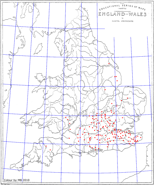
The present occurrence and distribution of the name can be seen on the map (fig. 1). It shows one hundred and fiftyThere seem to be only 146 on the map. instances which I have identified. No doubt other instances can be supplied by those with a more intimate knowledge of local {242}{Fig. 1}{243} unrecorded place-names than I can pretend to. But I venture to think that the occurrences which I am able to record are sufficient to define the area of distribution for my purpose.
The map shows that the greatest number of Coldharbours is found in south and central England. Starting from the south coast in the vicinity of Portsmouth and Chichester Harbours we can trace two distinct lines or routes, one through Sussex roughly on the line of Stane Street, the other to the west of Hampshire following the Test Valley. Thence they spread roughly over the watershed of the Thames, the whole of Kent, and parts of north Sussex. They spread farther into the upper watershed of the Ouse, and a few isolated examples are to be found round the Wash and Humber, in the Wye Valley, and even in north Somerset and Devon.
Having said so much of the present I shall now endeavour to throw some light on what Coldharbour stood for in the past. And first I think we may dismiss the idea that the name has come down to us in any very corrupted form. In the earliest form of which we have any record it is Cold Harbarow, and practically the only variants now are Cold Harbour and Cold Borough, the former almost universal. Were it a corruption of some Latin or Celtic term it is scarcely conceivable that in the numerous instances where it has survived as a local and unimportant place-name, it would have come down to us corrupted into a precisely similar form.
The description intended is what the word denotes, a Cold Harbour. The problem to be solved is: for what purpose or use did it exist. I must again call to my aid Silchester, Calleva Atrebatum, that storehouse of information on our early history which has scarcely yet been sufficiently appreciated, except in the purely Roman features that it records. A Coldharbour exists, or rather did exist till recently, in the parish of Silchester. The name was formerly borne by a cottage and small parcel of ground on the road from Silchester to Little London close to the Scotsman’s Green, at a distance of 11 furlongs from the centre of the city and just within the boundary of the leugata, roughly midway between the roads to Winchester and Salisbury. An examination of the ground in the vicinity reveals that upon it converge three of the banks and ditches which lead from the south gate to Pamber forest. These ‘intrenchments’, as they are described on the ordnance maps, are ditches of varying depth and contour with a spread bank on one or both sides. They follow no very direct course but wander about like the modern lanes; in fact they actually constitute lanes in portions of their length.
{244} Some years ago I cut a section down to the undisturbed soil across one of these so-called intrenchments to see if I could ascertain their object or meaning, but I only found a rounded depression with a bank composed of soil thrown up, or rather {Fig. 2} spread over, the adjoining surface, and I came to the conclusion that there was nothing to suggest a definite ditch or parapet. It was not until I had read the paper of our Fellow Mr. Kitson Clark,1 on similar banks and ditches in Yorkshire that I realized the true meaning of these features at Silchester. ‘When’, he {245} says, ‘men had to drive cattle from pastures of one kind to pastures of another kind … we can imagine that a definite track was quite necessary. The track would be ground into dust in dry weather, in wet it would be trampled into mire, and the mud might be taken up and deposited at the side of the track just as happens in our day … and the banks might even be accentuated purposely to prevent straying.’
1 Proc. Soc. Ant., xxiii, 321.
The intrenchments at Silchester correspond to all these conditions, and there can, I think, be no room for doubt as to their being cattle tracks. And at the intersection of three such cattle tracks is the Coldharbour at Silchester (fig. 2). It follows that we must assume that for a long period, perhaps many centuries, cattle were driven in and out of the Coldharbour whatever it was.
At Lambourn, which has so many features in common with Silchester as to suggest a similar date for its original settlement, we find on the Downs some two miles south-east a Cold Borough Hill, and just below it in a sheltered bottom an extensive meadow called the Winter Down (fig. 3). At one end of this meadow is the Winter Down Barn situate beside a square entrenched enclosure. This entrenchment is obviously very ancient. The old turf has reasserted itself on bank and ditch, giving it the appearance of other prehistoric earthworks on these Downs. From the north, this enclosure is approached by a cattle track some mile in length, and from the south a short length of a similar track remains, but cultivation which here reaches within a short distance of the enclosure has obliterated its further course. The Barn, a very ancient structure, has cattle-shedding adjoining it. Here, then, we have what is obviously a cattle enclosure with covered shelter and a barn for storage of fodder situate on Cold Borough Hill, a winter shelter for cattle, in other words Cold Harbour. This, then, is the meaning of Cold Harbour, the Winter or Cold Season shelter, or Harbouring for cattle.
The clue which is thus supplied to explain the nature and use of Coldharbour will be found, if applied to almost any occurrence of the name, to be quite consistent with local circumstances and position. We have almost universally the same enclosure still in very many instances combined with a farmsteading or shedding, the situation isolated from other buildings, most usually away from any main road, past or present, and as at Silchester well away from the settlement centre, and,beyond the limits of the cultivated common field.
And were further confirmation needed it can, I think, be found in the numerous instances of Coldharbours on the great salt marshes where pasturing of cattle must always have been, as it is {246}{Fig. 3}{247} still to-day, the only use to which they are adapted. What other use could Coldharbours have served in such situations than as cattle shelters?
Among this latter category must be included the Coldharbours which till recently were to be found round London. Thus there was a Coldharbour at Deptford, south of the Surrey Commercial Docks, another on the site of Blackwall docks, one on the rising ground above what is now Battersea Park, and yet another near the Tower, another in modern Thames Street, another at Kingsland, all on or adjoining the marshes on the banks of Thames and Lea. That at Thames Street ad foenum on the ancient hay wharf, perhaps records the stall-fed cattle for milk or meat supply of the City.
The frequent and widespread occurrence of the name in south-central England must bear record of a time when this district was inhabited by a population who were principally concerned with cattle.
Can we say who these people were and when they introduced the use of Coldharbours? To assign a date for the origin of Coldharbours is a task of great difficulty: of direct evidence there is little if any. What there is is purely inferential.
As I have already said, the connexion of Coldharbour with sites known to have been occupied in the Romano-British period has long been recognized, and at Silchester we have the further direct connexion of the cattle tracks with the Coldharbour. All the evidence that can be deduced from their character, situation, and direction points to their being contemporary with the period of occupation of the city, that is, not later than the fifth century. But the evidence, while not conclusive, yet clearly supports a strong presumption of such date for their use, and consequently for the period of the Coldharbour to which they lead; and further presumption of the contemporary use of Coldharbours with the period of occupation of Silchester can be based on the number found in its vicinity. They would scarcely have been established in such numbers round a deserted city, such as Silchester became, and long remained, after the fifth century. In yet another direction we can draw certain very strong inferences as to date, and also as to what people first instituted Coldharbours.
If the area of distribution be studied on the map it will be seen that this area coincides to a very large extent with that in which we have evidence of the Gaulish polygon settlement. The same route inland from the coast as indicated by those settlements is suggested by the line of Coldharbours stretching up the line of {248} Stane Street, and that passing up the valley of the Test to the west of Hampshire. And the absence of Coldharbours in those parts which were occupied by non-Belgic tribes is very significant. It is entirely absent in East Anglia and Essex; the territory of the Iceni and Trinobantes and the region of occupation of the Durotriges in Dorset.
It may be suggested that they belong to the period of early Anglo-Saxon settlement. But all the evidence that can be derived from their situation is against such a theory. They in no way correspond with any of the recognized settlement areas of this period as defined by the position of the cemeteries of the pagan or early Christian periods. They are to be found alike in the Jutish area of Kent, in Wessex, and some even in Mercia, suggesting no special relation to either.
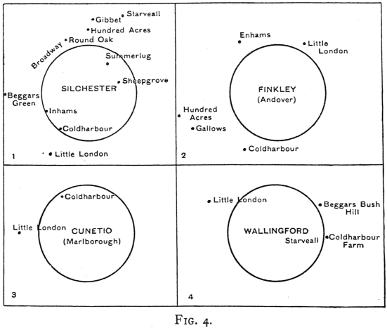
I come now to my last argument in support of the attribution of Coldharbours to the period of the later Belgic or rather Gaulish invasion, to the period to which the foundation of Silchester and similar polygonal settlements belongs. Here my process of reasoning is based on the persistence of a group of place-names found associated and in conjunction with Coldharbour, which I think can be proved to belong to, and survive from, the period of the Belgic settlement. Adequately to illustrate my case I should need to reproduce large-scale maps of a considerable area of England, but limitations, if only of space, render this course impossible. I am therefore obliged to fall back on sketches or diagrams of place-name groups in the vicinity of various places.
The first example I take from Silchester. And as the leuga radius or banlieue, which can still be clearly recognized here, is an important factor in the grouping of the names, I reproduce it as a circle of the leuga radius. A similar circle of the same radius is introduced into all the other groups I shall refer to, as although in many instances no trace of its existence survives I assume for the purpose of my argument that it was in fact always present, because the relative grouping of names still remains governed by its limits. The group here comprises
(1) Names derived from the leuga Boundary—‘Broadway’,
Round Oak’.
(2) Agricultural. ‘Coldharbour’ the winter cattle shelter, and
‘summerlug’ the summer cattle quarters. This last meaning is
warranted by the fact that the ‘summerlug’ has similar cattle tracks
around it as the Coldharbour and ‘sheep-grove’.
(3) ‘Beggars Bridge’ and ‘Gibbet’ which speak for
themselves.
(4) ‘Hundred Acres’, ‘ Inhams’, ‘Starveall’,
‘Little London’, whose meaning is obscure.
{249}{Figs. 4,5}{250} I propose to show that this place-name group is not confined to Silchester, but can be found repeated wholly or in part in very many localities where Coldharbour also is found.
Fig. 4, No. 2 shows a group centred round Finckley the site of the Roman station near Andover, which ceased to be occupied at the same period as Silchester.
No. 3, part of a similar group round Mildenhall near Marl-{Fig. 6}borough (Cunetio), which also ceased to be occupied after the Roman era.
No. 4, a group round Wallingford where remains of the Roman period are clearly established.
Fig. 4 shows the same group of names occupying, relative to the leuga radius, very similar positions, and in three instances at least the grouping can only have reference to a period before the Saxon Conquest, after which the sites ceased to be inhabited.
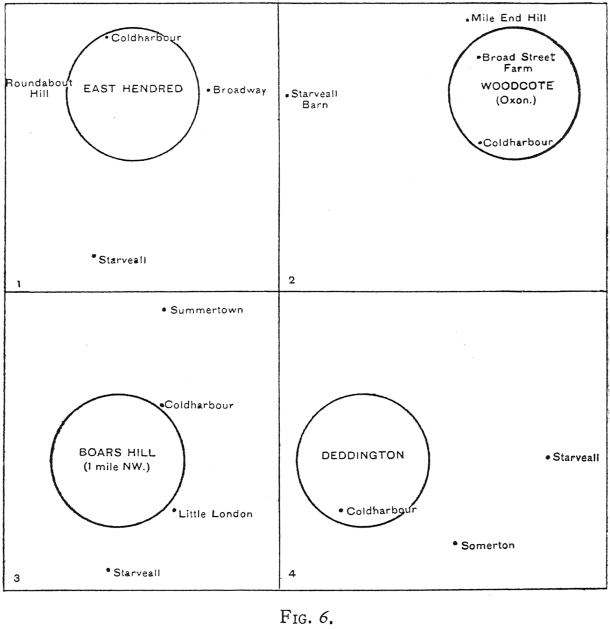
Fig. 5 shows examples which can be also dated to the same period.
{251}
No. 1. Lambourn, whose close similarity to Silchester I have already noted.
No. 2. Brill in Buckinghamshire in the vicinity of the Roman Camp on Muswell Hill.
No. 3. Great Woodcote on Banstead Downs where sufficient remains of Roman buildings existed in Camden’s time for him to identify it as Noviomagus.
{Fig. 7}
No. 4. The British village near Stanton Harcourt in Oxfordshire.
In all these instances we have occupation in Romano-British times, and evidence of the connexion of the place-name group with the Gaulish leugata; from which I think we can safely assume that Coldharbour and its associated names belong both to the Romano-British period and to the Gaulish type of settlements which still survived during that period with their leugata system.
From this it follows that other examples of the same place-name group may safely be attributed, where found, to a similar period.
Fig. 6 gives examples in North Berks. and South Oxfordshire which may be presumed to have been within the political influence of the Atrebatian capital at Silchester.
{252}
No. 1. East Hendred near Wantage, where Broadway and Roundabout Hill record the leugata boundary.
No. 2. Woodcote, just beyond the Thames twelve miles north of Silchester. Here the Mile End and Broadstreet are noticeable.
No. 3. A group centred south of Oxford on the Berks. side of the river.
No. 4. A very similar group at Deddington some fifteen miles {Fig. 8} north of Oxford, in both of which the ‘Summertown’ survives with the Coldharbour.
Fig. 7 shows No. 1, Yeading, four miles east of Uxbridge, a very complete group, and three examples in Kent, Nos. 2, 3, 4. The Mile Oak remains at Brenchley.
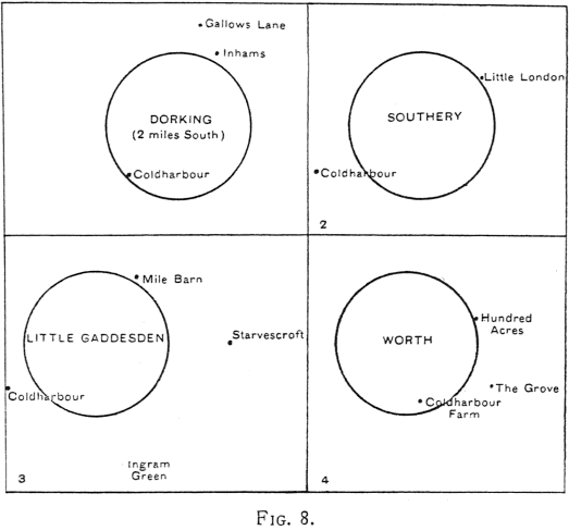
Fig. 8 gives a group, No. 1, two miles south of Dorking.
No. 2. Southery in Norfolk, near Ely.
No. 3. Little Gaddesden in Herts. where Mile Barn marks the leuga boundary.
No. 4. Worth in Sussex.
These examples by no means exhaust the groups I could cite and illustrate throughout the regions where Coldharbour is found , but I think they suffice to establish my case that Coldharbour, and its associated place-names, denote a settlement of Belgic tribes of the Silchester type-form. In other words, that any village or {253} town which has retained its Coldharbour can trace its pedigree back to a Belgic ancestry whose descendants have preserved the peculiarities of their civilization throughout all subsequent vicissitudes of our history, or the intrusion of other races and history.
I may fitly conclude my paper with these words written by Sir Francis Palgrave in 1832: ‘A dialect closely allied to Anglo-Saxon was spoken in Britain long before the arrival of the last invaders. The basis of Anglo-Saxon is Belgic … and without attempting to define the territories occupied by the Belgians in the days of Caesar … it must be admitted so far as the boundaries of these tribes extended the Belgic tongue was spoken.’1
1 The Rise and Progress of the English Commonwealth, p. 21.
Discussion
Mr. C. L. Kingsford was familiar with the City Coldharbour, which was first mentioned in 1319, not as a place but a house. It was south of Thames Street, outside the Wall on the foreshore and therefore not of the class under discussion. The collocation of certain place-names in various parts of the country was certainly remarkable, and could hardly be accidental, but as some at least were agricultural, they could occur anywhere. It was however curious to find so many instances of Little London, though they could not date from the early period suggested. St. Nicholas Cole Abbey had been derived by some from Coldharbour, and one at the Tower was connected with Pepys.
The Director said the Coldharbour at the Tower adjoined the White Tower, and was certainly so called in the fourteenth century: it was difficult to see how it could be connected with agriculture. The whole subject was of absorbing interest, and the Society was indebted to Col. Karslake for bringing it forward; but it was not only natural but useful to bring all possible objections against the theory to test its merits. The names found in groups, whether of ancient or modern date, could hardly represent pre-Roman conditions, even if the polygonal enclosures could be taken as evidence. of Gaulish settlements.
Mr. Baildon entered a caveat against any philological conclusions from Coldharbour, and pointed out that Little London was not uncommon in the North of England where there were no Coldharbours. That the latter were cattle-shelters was a suggestion he could accept, and a dialectical analogue of the name might perhaps be recognized in the Summerseats and Summerscales of Yorkshire; but there was probably no Belgic population so far north, and he was not prepared to endorse Palgrave’s argument. It seemed rather venturesome to equate Ingham, Ightham, Ingram, etc., and the connexion of such name-groups with ancient inhabited sites proved too much, for no special shelter would be required in the neighbourhood of permanent farm-buildings.
{254}
Mr. Bonner welcomed a fresh treatment of an old problem. Ten
years ago he had compiled a list of Coldharbours from the ordnance maps and
found no less than 240 instances in England. In each case he had noted the
distance from any Roman road, and height above the sea, the result being fatal
to the theory that Coldharbour implied a Roman road wherever found. Col.
Karslake had stated there were no instances on Roman roads, but he had himself
found five on Roman roads and six within a short distance of them: about
two-thirds of the total were, however, well away from such lines. The names
Starveall and Hundred Acres were Anglo-Saxon, but Coldharbour had not been found
in our records earlier than the thirteenth century, its medieval spellings,
however, clearly indicated its Teutonic origin—a conclusion accepted by
philologists and confirmed by the Oxford Dictionary. Sir John Pulteney also had
manors in Kent and six or seven of them included Coldharbours; his predecessor
had two manors in Kent, and both had a Coldharbour attached. The distribution of
the name was not quite as stated: it extended to Cornwall in the west and to
Northumberland in the north; Kent had 28 or more, Sussex 21, and Lincolnshire
came third with 17. The Anderida district included more than 20. There were both
Great and Little Coldharbours, the latter being probably used for a house of
later date; but in any form the term could hardly be earlier than the medieval
period, while one instance, in Salop, dated only from the nineteenth century.
The name was common in Germany also, as Kalt(e)herberg, a very significant fact.
In England it was a farm-name, and appeared to be one of a type of such names
(of which he read a selection) which were descriptive of the site or the
characteristics of the place; and its meaning was merely ‘cold
shelter’.
Col. Karslake replied that Little London in the City was behind All Hallows on the Wall, on the site of Broad Street, and probably belonged to the Kingsland group of place-names. Whatever its origin, Great Coldharbour ad Foenum was outside the Roman Wall and a suitable place for cattle-stalls. His critics had overlooked the fact that the Coldharbours were clearly related to early sites not inhabited after the Roman period, and the occurrence of Mile End showed that they were connected with the leugata system of Gaul. Silchester seemed to him decisive in that respect.
The President felt that every one present knew much more of the subject after hearing the paper, and the discussion had served to illuminate many aspects of the question. In his opinion, Col. Karslake had proved the main contention, but the early date suggested for the groups of place-names seemed to lack confirmation, the whole terminology being against a pre-Roman origin.