Journal of Geomancy vol. 1 no. 3, April 1977
{56}
Thanks for recently received IGR Journal No. 2. … I append below some remarks for the IGR letters page, in reply to the Keith Raison letter, and partially to Nigel Pennick’s editorial note:
Intervisibility is too complex a factor to incorporate into the statistical model, which, as I said in my article, considers the map as a plane. What one could do here, though, is, in the case of farm-house pseudo-leys for example, check to see if these possess any intervisibility properties in common with ‘true’ leys.
Obviously statistics cannot ‘describe’ the processes of folklore research connected with ley study. But this does not mean that folklore evidence is free from criticism. It simply means that statistics are not applicable here.
Keith Raison’s third point seems to have got a little muddled. In overall distribution, ancient sites and churches can be compared with a random distribution. Obviously individual sites are not random – they are planned – so that Nigel Pennick’s contention that Stonehenge could be proved to be random using suitable mathematical model misses the point. I repeat, we are talking about overall distribution, not individual sites.
Of course it is true that the more sites in an area, the more and better alignments one can expect by chance. The-more-the-merrier is certainly true of ley hunting. What one can expect by chance depends very much on how many sites there are in your area of study – a fact which seems surprisingly difficult to get across to ley hunters in general. In this Mr Raison is agreeing with me, not disagreeing.
The Warminster leys are explicable statistically insofar as Mr Goddard’s use of crossroads and other types of site increases the ancient site population of the Warminster region to the level where such effects become statistically likely. …
I was careful to point out in my Journal of Geomancy piece that the hexagon and vesica used anything modern on the map. The site population is thus very large. But then so is the Ancient Site population of the whole of Southern Britain, which was the area of study for Michael Behrend’s “Landscape Geometry of Southern Britain”. The question is, could Michael Behrend’s work be a similar series of fortuitous patterns arising from a high ley point population, a population large enough to enable one to play geometrical games of quite extraordinary intricacy? – {57} A great deal of work is required to investigate this matter, and for the present it must remain a matter for personal belief or disbelief.
Finally, on the subject of fieldwork, yes, that is something of a failing from the ley hunter’s point of view. But (a) what could fieldwork uncover OFF a ley as opposed to ON it? (b) What could fieldwork turn up on a pseudo-ley (eg. a farmhouse alignment)? (c) Fieldwork uncovers sites ‘not on the map’. A new statistical model then becomes necessary to compute the alignments not just amongst ‘shown’ (on the map) sites, but amongst the ‘not shown’ ones as well. In other words, fieldwork could be taken into account if we had all the relevant data as to the number of sites missed and left unrecorded on the maps by the Ordnance Survey.
////////////////////////////////////////////////////////////////////////////////////////////////////////////////////////
Editor’s note: My reference in J. Geomancy 1/2 on mathematical
models concerning Stonehenge, was to the effect that if one wants to disprove
something mathematically, a suitable formula can no doubt be advanced in order
to back up the theory. As with the cases of God or ghosts, there are vehement
believers and disbelievers for the ‘existence’ or otherwise of leys.
Those who believe know them to exist as deliberate planning – those who
disbelieve know them to be chance. Objective proof in the scientific sense
cannot be forthcoming. Just as ‘science’ (whatever that is) does not
‘recognize’ dowsers, that does not prevent dowsers from practising
their craft and making a living from the positive results obtained.
........................................................................................................................
Dear Nigel, Thank you for the Journal of Geomancy … and Occasional Paper No. 6. Sorry to learn that a copy of the Journal went astray in the post.
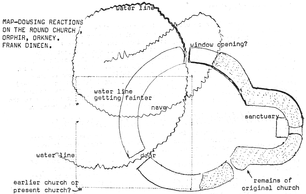
I found the Occasional Paper on Orphir very interesting, especially the plan of the church. I am enclosing a copy of the plan with some of the dowsing reactions obtained. I have included the main water line. … Where the water line entered in the south west was where the door was, and there was an opening similar to the putlog hole in the north wall where it emerged. The same water line curved round and went through the church a second time, but that seems to have been ignored. I think both the putlog hole and sanctuary opening are over water lines.
There is a trace of another structure overlapping the site to the south west. The pendulum indicates that it was an earlier building, but the way the chancel or apse fits into the round church suggests a later structure. I note from the paper that there is a Presbyterian church now on part of the site. The other structure does not seem to take account of the water lines and is oriented almost exactly east.
In the Journal I was fascinated to read about the E. Anglian church towers and find myself particularly interested in Rickinghall (Inferior) ‘sitting at the bottom of a valley’ as I have not come across a church in Essex in that position and cannot recall one anywhere else either. I consider the site therefore highly significant from a geomantic point of view and requiring some special explanation.
The references to the Knights Templar reminds me of an odd experience with Fryerning church which is between Ingatestone and Blackmore. When I first map dowsed the church I got an unusual water line reaction. There were two which crossed in the South East of the nave. Next time I dowsed I got another almost circular reaction, but its position made the previous lines look like an eye. So I went out to the church to check and got a stabbing jab in my chest as I approached the South East corner. I could not find one of the water line exits in the chancel, but found another one instead. The circular iris of the eye was there, but it would be necessary to dowse inside the church to check whether the ‘lids’ were complete. {58}
////////////////////////////////////////////////////////////////////////////////////////////////////////////////////////
Subsequent to the above, Frank wrote the following, after the Round Church
remains had been shown on a television program, the Presbyterian church having
been removed.
________________________________________________________________________________________________________________________
Thinking over the fact that the Presbyterian church no longer overlaps the site of the round church at Orphir, it occurs to me that the uncertainty about the period of the structure dowsed may have arisen from its removal. Because of the information in Ian Worden’s article I had assumed that the Presbyterian church was still there whereas the dowsing reaction indicated the structure to be earlier than the present site. Strictly speaking, since the Round Church still exists, even though a ruin, and the Presbyterian Church does not, the structure was earlier than the present site, though not built before the Round Church. It is a matter of asking the right question.
… Not having been able to dowse a ley line to my satisfaction, I found the article by Major B.W. Haswell particularly fascinating. His description of ley-width clearly shows that he is reacting to some objective type of phenomena and the straightness of the line indicates that it does not relate to the geodetic lines of Guy Underwood, though his reference to the line going through gates sounds familiar and similar to Underwood’s track lines. His remark about being drained of energy near Godborough rings a bell with me. I had a similar experience when working at Lee Chapel early in 1975. There are some unusual dowsing reactions in the area where I believe the chapel used to stand. During the summer of last year, however, I returned to dowse the site in the dry conditions and experienced the exact opposite, an inflow of energy and vitality. I came away feeling ‘high’. The dowsing reactions, however, were exactly the same. I have since come to the conclusion that the natural flow of earth currents in the area is subject to blockage by the new development, with its dense housing, large areas of concrete and tarmac, and disastrous ‘landscaping’. It may be that the drawing away of personal energy had something to do with the disappearance of Lee chapel in the first place.
Continuing Major Haswell’s Ley No. 2 for about 60 miles on a large scale map shows it is closer to Stonehenge than Salisbury Cathedral and seems to pass through Wilsford, on the Avon south of West Amesbury. However, a line which is straight on the earth’s surface must begin to curve on a map after a certain distance, if it is to be accurate.