PREHISTORIC TRACKWAYS.
By Raby Mellas.
EVIDENCE that a sighting-method was practised in prehistoric Britain was given by Mr. Alfred Watkins, F.R.P.S., in a lecture at the Royal Photographic Society, Russell-square.
Mr. Watkins has spent much time and pains in obtaining facts from which such a conclusion could be drawn, and gave many of these, and the deductions he has made from them, in such a manner as to make the lecture, well-illustrated with lantern slides of photographs taken by him, of absorbing interest. In considering the subject, the mind must first be cleared of attempts to confuse these traces of prehistoric road evolution with the Roman system, which followed long afterwards. In fact, these prehistoric trackways were as ancient to the Romans, on their occupation of Britain, as the Roman invasion is to us.
In this connection, an extract from the “Gentleman’s Magazine,” January, 1822, where it is stated that “having introduced a conversation concerning Roman roads in Herefordshire, a gentleman communicated the following account of a fine British trackway, improved by the Romans … for Herefordshire contains British and Roman antiquities hitherto unexplored …” is of interest.
The keynote of the facts on which Mr. Watkins has drawn his conclusions is the presence of tumuli, or artificial mounds. It has been noted, he stated, by many writers, how they command long-distance views from at least two opposite directions, how often they are found on a hill-ridge strongly defined against the skyline, how they seem to occupy the oldest existing trackways, and in many cases tracks or roads are directed straight at them.
One of the earliest examples noted by Mr. Watkins is in the Radnor–Hereford district, where three such earth works, Turret Tump, the camp above Eardisley, and Amely Twt, or mound, were in alignment on the map, and that this straight line, if extended, terminated at lofty points, Glascwm Hill at one end, and Birley Hill at the other. The line also passed through a moat in Sarnesfield Coppice, through Weobley Church, and several homesteads, with ancient place-names. Taking this as a clue, Mr. Watkins soon came upon other examples, a striking fact being the way in which moats and ancient churches fell in alignment with the mounds. The lines also fell upon ancient camps and earth-works in so great a number that the suspicion of coincidence was disposed of. In all these alignments it was found that fragments of existing roads or tracks fell upon the lines extending in some cases to quite a good stretch of road, from half a mile to several miles. In many instances the line passed through small ponds, many such having an island in the middle through which the line passed, and others, when cleaned out in the dry season, showing a road through the bottom. Mr. Watkins deduced from this that a beacon light, which is always found on the sighting line, reflected at night from the level plane surface of the pond, artificially planted there for the purpose, and served to verify the line of the ley.
Taking the mounds and moats which align across miles of country, and noting burial contents found in many of them, dating from the Neolithic or Bronze Ages, the only logical conclusion is that such alignments were actually made by prehistoric man.
In surveying between sighting points, Mr. Watkins found abundant evidence from fragments of track, additional marking stones, sighting cuttings, water-sighting points, etc., that these alignments were made to meet the needs, such as salt, flint-flakes, and later, metals, of a primitive people. Such straight trackways, across hill and dale and up the sides of mountains, filled their requirements for some time, but doubtless with advancing civilisation a desire for easier ways, winding along a mountain ridge instead of going straight over it, must have arisen; and the sighting track was neglected till the Romans came, and probably planted on the remains of such their long-wearing stone surfaces.
These conclusions have been found by Mr. Watkins to be verified in the most remarkable manner by British place-names, earth-sighting points on higher ground bearing the name of tump, mound, twt, castle, bury, cairn, garn, tomen, low, barrow, knoll, knap, moat, and camp. The suffix “ley,” which is not thought by him to indicate a meadow, as is usually supposed, is found in a variety of instances; “ton” indicates a markstone on a ley; “bury” clearly indicates a mound which was a sighting tump; “low” is the universal name for the mound in Derbyshire, towns like Ledbury first grew round one of these mounds. Local dialect supplies countless proofs of the derivation of such place-names.
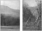
The photographs of earth cuttings shown by Mr. Watkins were, to my mind, most conclusive evidence as to the correctness of his deductions. Whenever a mountain ridge stood in the path of a ley, the Surveyor, it is assumed, cut a trench at the right angle and in the path of a ley. This shows as a notch against the sky-line, and Mr. Watkins counted eight such artificial notches in the mountain ridge when on the road between Llanvihangel Crucorney and Longtown. Each notch can only be seen on the line of sight, and disappears when a quarter of a mile right or left. Such a notch is illustrated in the accompanying plate.
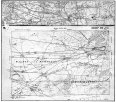
The map reproduced demonstrates the strong nature of the evidence leading to Mr. Watkin’s deductions, and further verification can be obtained in the following manner, suggested by him, with an inch to mile ordnance map and a straight edge:—Taking all the earthworks mentioned, add to them all ancient churches, all moats and ponds, all castles (even castle farms), all wayside crosses, all cross roads or junctions with a place name, all ancient stones bearing a name, all traditional trees (such as gospel oaks) marked on maps, and all legendary wells. Make a small ring round each. Stick a pin on the site of an undoubted sighting point, place a straight edge against it, and move it round until several of the objects named and marked come exactly into line.
It will be found that on that line will be fragments here and there of ancient roads and footpaths, also small bits of modern roads conforming to it. If the line is extended into adjoining maps, new sighting points will be found on it, and it will usually terminate at both ends in a natural hill or mountain peak, or sometimes, in later examples, in a legendary well or other objective.
It may be asked why churches should be taken as evidence of early trackways when they are clearly of a much later date. The answer is found in the fact that when Christianity was introduced, it was a practice to erect churches and sacred objects on old Pagan sites. For instance, a church is often found built on an old mound in which objects have been discovered which prove it to have been a pagan burying place, and therefore probably of Pagan superstitions and rites. Practically all ancient churches are on the site of these sighting points (tumps or stones), and in some cases there is evidence that the churchyard cross is on the exact spot of the ancient marking stone. In Johnson’s “Byways of British Archæology,” a chapter on “Churches on Pagan Sites” goes fully into the subject.
So much of interest, from the point of view of the archæologist, from that of the student of ancient language and its survival, from the modern surveyor interested in roads, and from many others, is to be found in this subject, that it is impossible here to do more than touch on a few points. At any rate, I was sincerely, not politely, sorry when Mr. Watkin’s lecture was over, and was delighted when I found that it was possible to learn more from the vividly-interesting book, written by him, entitled “Early British Trackways.” This book, which I have since read, goes at length, and in a more logical and consecutive manner than I can hope to attain, into this fascinating subject. The photographs contained in the book, as well as clearly illustrating the points made, are an artistic treat, especially to a lover of the West Country, and are also a witness in themselves to the untiring and painstaking nature of Mr. Watkin’s investigations.


A long and favourable account of Watkins’s lecture to the Royal Photographic Society.