![]() Nine Wells
Nine Wells
Can be done on foot or by bike although you'll need to leave your bike outside Nine Wells wood. Just over 3 miles to the starting point and then
a circular walk of 2.5 to 3 miles.
Start at the junction of Red Cross Lane and Hills Road. This is about 200 metres out of Cambridge on the right beyond the Addenbrooke's Hospital roundabout. This excursion can be combined with the Hobson's Conduit walk to make a longer stroll/ride starting in the city centre.
Walk up Red Cross Lane passing the Bell School and Educational Trust, where I worked for some years. Go through the gate which marks the end of the road and continue onto the path, passing over an access road onto a wide concrete track. Turn left onto the poshly tarmaced cycle path. Follow the path through fields, round right and left turns, eventually reaching the railway line to London. Follow the path next to railway line, heading south towards Shelford. Views of hills (good God!) appear ahead of us: Wandlebury leftish and Granham's straightish. Shortly, where the path meets a stream that runs under the railway, we bear left towards the trees of Nine Wells alongside the stream - Hobson's Conduit. However, if desperate for a drink, you could follow the cycle path straight on to Shelford, returning to the Nine Wells turn after libations.
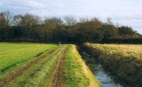 Looking along Hobson's Conduit
back to its starting point in Nine Wells wood beyond.
Looking along Hobson's Conduit
back to its starting point in Nine Wells wood beyond.
Enter Nine Wells via a little bridge - bikes will have to be locked outside. Explore Nine Wells wood at your leisure. At the back of this end of the wood is an obelisk marking the exploitation of the wells, the best part of 400 years ago. They supplied water via Hobson's Conduit to Cambridge - quite a feat of engineering. Deep furrows, sometimes nearly dry in summer, springs and wiggly paths appear at every turn. Emerge from an exit at the far end but same side that you entered from.
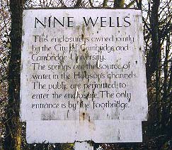 Notice the old, rather tired sign and newer information board
a few metres in from the exit. Turn right onto the path. A
few metres on we bear left and then follow the path right at a strange cage
like structure. Continue on past a smaller wood. Further on
our path meets a T-junction: turn left back in the direction of Addenbrooke's hospital.
After a short distance, just before a thick hedge, you come very close to the cycle
path you came down earlier. Ignore this and turn right down the broader cycle path alongside the hedge,
taking you out onto the Babraham Rd, via the odd kink or two.
Turn left down the cycle path alongside Babraham Rd back to the starting point at Red Cross Lane.
The nearest pub is the Queen Edith on Wulfstan Way, 5 mins away by bike.
A few years ago they knocked the old Queen Edith down and build the new version a bit nearer the road, thus known by some as the QE2.
Notice the old, rather tired sign and newer information board
a few metres in from the exit. Turn right onto the path. A
few metres on we bear left and then follow the path right at a strange cage
like structure. Continue on past a smaller wood. Further on
our path meets a T-junction: turn left back in the direction of Addenbrooke's hospital.
After a short distance, just before a thick hedge, you come very close to the cycle
path you came down earlier. Ignore this and turn right down the broader cycle path alongside the hedge,
taking you out onto the Babraham Rd, via the odd kink or two.
Turn left down the cycle path alongside Babraham Rd back to the starting point at Red Cross Lane.
The nearest pub is the Queen Edith on Wulfstan Way, 5 mins away by bike.
A few years ago they knocked the old Queen Edith down and build the new version a bit nearer the road, thus known by some as the QE2.