![]() Limekiln and Fulbourn Nature Reserves
Limekiln and Fulbourn Nature Reserves
Can be done on foot or by bike: I'd recommend the bike to speed
up the bits on the road and going on foot in the nature reserves. About 3 miles out to the starting
point and then about 9 miles.
Start at the junction of Cherryhinton Road, Queen Edith's Way and Cherryhinton village High Street, to the south east of the city.
If you are using a bike you'll need to lock it up near the junction. Walk into Queen Edith's way: after a few yards you will see an entrance to the Limekiln Close Nature Reserve on the left. Explore this interesting patch of wild undergrowth and steeply banked hollows on foot. Exit the same way turning left and then immediately left again up Limekiln Road, on foot. Turn right into the entrance on the right to the caravan site - you'll see an information board for the Nature Reserve. Turn immediately left up the narrow path through the trees. Follow the path climbing steeply at times, up to the top of the chalk pit. It is a surprisingly wild and remote site, yet so close to the built up area. I have seen Muntjac deer on occasion. There are views down to the grassy caravan site below. From the open green area right at the top you get great views over Cambridge. Loop round back into the wood - keep a look out for the remains of a lime kiln just off the path. Descend back down the same way you came in. Nearly opposite the entrance is yet another nature reserve that was once a large chalk pit. It is much more stark as there is little mature vegetation in the main part of the pit and it is surrounded by sheer chalk cliffs. Peregrine falcons have nested for some years on the cliff face near the far end on the right.
Return to your bike and head straight across Cherryhinton Road into the High Street of Cherryhinton village. Duck pond to your left at the junction. Keep going for about half a mile. Turn right down a narrow path as soon as you've crossed the railway line - it's quite easy to miss. When you come to a road turn right over the railway crossing and then immediately left along the cyle path: the railway line will be on your left and Tesco's on your right. The cycle path ends at a small road - continue straight onto this, following it up the hill. Continue on down the hill following a larger road straight ahead into Fulbourn village - don't take the right turn. This road takes you into the middle of Fulbourn past the Baker's Arms and several sharpish bends. Turn right at the T-junction and on past some shops and the Six Bells. Turn left at the next T-junction, following the road around to the left of the attractive church. Just past the end of the churchyard wall the road turns sharp left: bear right off the road onto a path that takes you straight on in effect. Lock your bike up at the end, where a much broader track comes in on your right.
 Head into Fulbourn Nature
Reserve in front of you, having a look at the map on
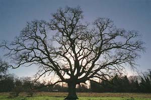
the board by the entrance. The large Ox Meadow in front of
you with the mature tree in the middle is full of cowslips
and wild flowers in spring. If you work your way round to the
left over a stile you will find what used to be called Zouches Castle,
the site of an ancient manor house. Only the
moat remains. There is an information board showing (when not
vandalized) how it might have looked. Follow your nose in a
wide clockwise sweep through woods (initially over a stile
and bridge beyond the far side of the moated area) and then
bearing right into more open meadows. If you head out of the
Reserve opposite where you came in you will see a well worn
path to the raised Fleam Dyke, an
Anglo-Saxon defensive earthwork, a few hundred metres south
east. You can walk on the Dyke to Balsham. Have a look at
this if the fancy takes you. Otherwise continue on clockwise
through the Reserve.
Head into Fulbourn Nature
Reserve in front of you, having a look at the map on
the board by the entrance. The large Ox Meadow in front of
you with the mature tree in the middle is full of cowslips
and wild flowers in spring. If you work your way round to the
left over a stile you will find what used to be called Zouches Castle,
the site of an ancient manor house. Only the
moat remains. There is an information board showing (when not
vandalized) how it might have looked. Follow your nose in a
wide clockwise sweep through woods (initially over a stile
and bridge beyond the far side of the moated area) and then
bearing right into more open meadows. If you head out of the
Reserve opposite where you came in you will see a well worn
path to the raised Fleam Dyke, an
Anglo-Saxon defensive earthwork, a few hundred metres south
east. You can walk on the Dyke to Balsham. Have a look at
this if the fancy takes you. Otherwise continue on clockwise
through the Reserve. 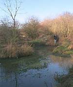 Further round there used to be
a small pond with an island in the middle and lots of frogs and
newts.
However, in recent years the water level got lower and lower: now it is an ex-pond sadly. As you continue on your circuit you come again into
woodland before returning across the meadow to the entrance.
Pick up your bike and head down the wide track that runs
south between woods. This brings you to Stonebridge Lane
where you could park if you're too lazy to walk or bike out
from Cambridge. Turn right at the road past a pleasant
triangle of grass bordered by fine houses. Notice the war
memorial with the sad addition of a Gulf War victim. On past Fulbourn
Manor to the junction by the church.
Further round there used to be
a small pond with an island in the middle and lots of frogs and
newts.
However, in recent years the water level got lower and lower: now it is an ex-pond sadly. As you continue on your circuit you come again into
woodland before returning across the meadow to the entrance.
Pick up your bike and head down the wide track that runs
south between woods. This brings you to Stonebridge Lane
where you could park if you're too lazy to walk or bike out
from Cambridge. Turn right at the road past a pleasant
triangle of grass bordered by fine houses. Notice the war
memorial with the sad addition of a Gulf War victim. On past Fulbourn
Manor to the junction by the church.
Cross over and round the corner past shops to the Six Bells pub for recuperation and a drink. There is a large garden at the back. Suitably refreshed, turn right out of the Six Bells and then right again at the junction, following the road south - the only one here you haven't been on. Turn right at the T-junction back up the hill to Cambridge. At the top on the left is a windmill with its full quota of sails. From here follow the road all the way back to our starting point.